

-
摘要:
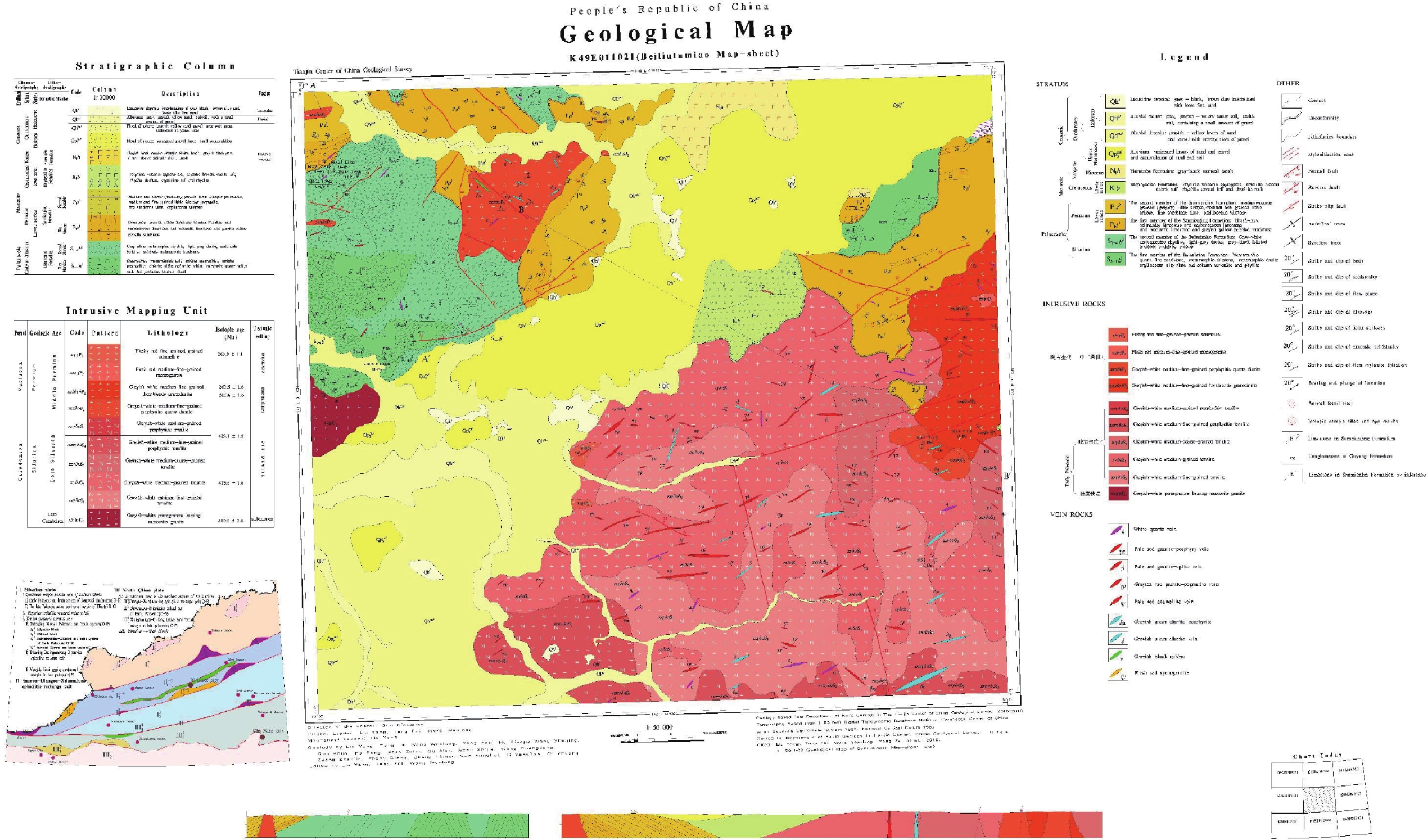
内蒙古北柳图庙幅(K49E011021)1∶50 000地质图根据《区域地质调查技术要求(1∶50 000)》(DD 2019–01)和行业的其他统一标准及要求, 充分利用1∶200 000区域地质、1∶50 000矿产调查工作资料, 采用数字地质调查系统(DGSS), 结合Spot、ETM、Aster等多种遥感影像对构造及岩性边界不断验证和完善, 最终绘制成图, 是内蒙古温都尔庙—白乃庙地区具有重要参考意义的成果图件之一。图件详细填绘了白乃庙岛弧带的物质组成和构造组合特点, 对志留系、二叠系、白垩系等沉积建造类型进行了重新划分, 把区内侵入岩划分为4个期次, 并构建了相对完善的构造演化序列。图幅数据库的数据内容包含有3个非正式填图单位、10个正式地层单位、4期岩浆事件和2期构造变形, 以及176个样品的岩石全分析数据, 10个样品的锆石U–Pb年龄数据,数据量为28.9 MB。该图幅细化了北侧温都尔庙构造带向南侧俯冲过程形成的白乃庙岛弧带的构造、岩浆演化过程, 反映了1∶50 000区域地质调查最新示范性成果, 对温都尔庙造山带古生代构造演化具有重要的科学研究价值, 对后续该区域的地质调查工作也具有参考和借鉴意义。该图幅为中国地质调查局第一幅开展智能化区域地质调查填图的试点图幅, 首次实现了中国区域地质调查工作的全流程智能化野外调查。
Abstract:According to the ‘Technical Requirement for Regional Geological Survey (1∶50 000)’ (DD 2019–01) and other uniform standards and requirements, and making full use of the data for 1∶200 000 regional geological and 1∶50 000 mineral survey, the 1∶50 000 Geological Map of Beiliutumiao Map-sheet (K49E011021), Inner Mongolia was compiled by adopting the Digital Geological Survey System (DGSS) in combination with Spot, ETM, Aster and other remote sensing images to continuously verify and modify tectonic and lithologic boundaries. As an achievement with important value of reference in the Wenduermiao-Bainaimiao area of Inner Mongolia, the map provides detailed information on the rock composition and tectonic association of the Bainaimiao island-arc belt. We re-divide sedimentary formation into different types, i.e., Silurian, Permian, Cretaceous, and classify intrusive rocks in the region into four phases, establishing a relatively complete tectonic evolutionary series. The map database includes three informal mapping units, 10 formal stratigraphic units, four periods of magmatic events and two tectonic deformations, as well as the whole rock analysis of 176 samples, and zircon U–Pb ages of 10 samples, with a data size of 28.9 MB. The map details the tectonic and magmatic evolution process of the Bainaimiao subduction belt formed in the southward subduction of the Wenduermiao tectonic belt in the north. Reflecting the latest results of the 1∶50 000 regional geological survey, the database holds important scientific value regarding the Paleozoic tectonic evolution of the Wenduermiao orogenic belt. It may also serve as an important reference for subsequent geological surveys in the region. As the first pilot map of China Geological Survey to apply comprehensive regional geological survey mapping, the present project represents the first time to realize whole-process field investigation in China’s regional geological surveys.
-

-
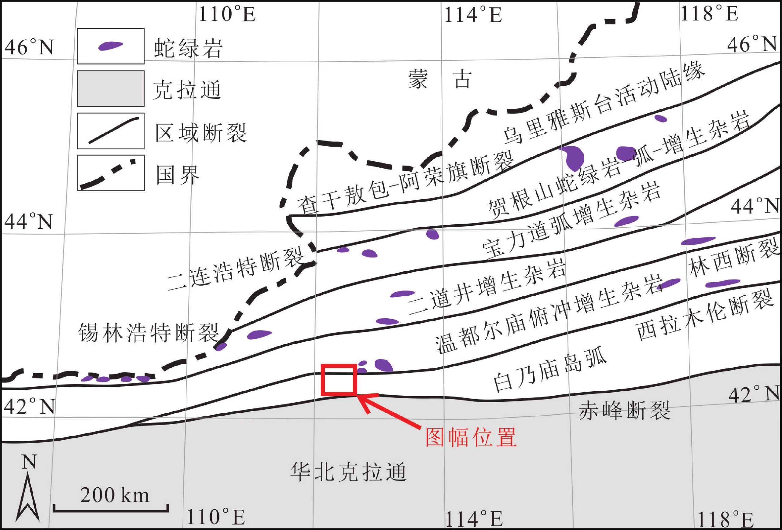
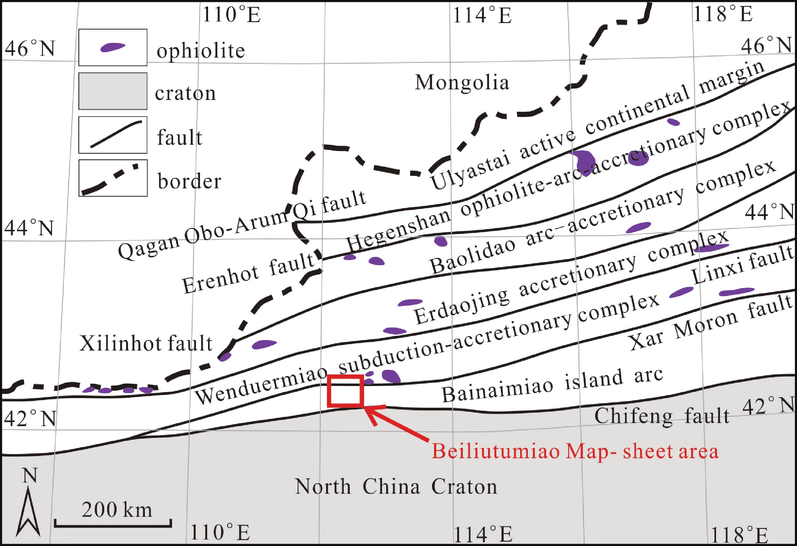
图 1 内蒙古北柳图庙幅(K49E011021)大地构造位置图(据Xiao WJ et al., 2003修改)
表 1 数据库(集)元数据简介
条目 描述 数据库(集)名称 内蒙北柳图庙幅1∶50 000地质图数据库 数据库(集)作者 沉积岩类: 刘 洋, 中国地质调查局天津地质调查中心
火山岩类: 滕 飞, 中国地质调查局天津地质调查中心
岩浆岩类: 王文龙, 中国地质调查局天津地质调查中心
变质岩类: 杨泽黎, 中国地质调查局天津地质调查中心数据时间范围 2016—2018年 地理区域 经纬度: 东经113°00′~113°30′; 北纬42°00′~42°20′ 数据格式 MapGIS 数据量 28.9 MB 数据服务系统网址 http://dcc.cgs.gov.cn 基金项目 中国地质调查局地质调查项目“内蒙古温都尔庙-镶黄旗地区区域地质调查” (项目编号: DD20190038) 语种 中文 数据库(集)组成 北柳图庙幅1∶50 000地质图数据库包括: 1∶50 000地质图库、角图和图饰。地质图库包括沉积岩、火山岩、侵入岩、第四系、构造形迹、地质界线、产状、矿化(点)、蚀变、岩性花纹、各类代号等。角图包括综合柱状图、侵入岩填图单位、图切剖面、大地构造位置图。图饰包括接图表、图例、责任表等  下载: 导出CSV
表 2 地质图空间数据库数据属性表
数据类型 名称 标准编码 数据项属性 基本要素类 地质体面实体 _GeoPolygon 地质体面实体标识号, 地质体面实体类型代码, 地质体面实体名称, 地质体面实体时代, 地质体面实体下限年龄值, 地质体面实体上限年龄值, 子类型标识 地质(界)线 _GeoLine 要素标识号, 地质界线代码, 地质界线类型, 界线左侧地质体代号, 界线右侧地质体代号, 界面走向, 界面倾向, 界面倾角, 子类型标识 产状 _Attitude 要素标识号, 产状类型名称代码, 产状类型名称, 走向, 倾向, 倾角, 子类型标识 样品 _Sample 要素标识号, 样品编号, 样品类型代码, 样品类型名称, 样品岩石名称, 子类型标识 照片 _Photograph 要素标识号, 照片编号, 照片题目, 照片说明, 子类型标识 素描 _Sketch 要素标识号, 素描编号, 素描题目, 素描说明, 子类型标识 化石 _Fossil 要素标识号, 化石样品编号, 化石所属生物门类, 化石属或种名, 化石产出层位, 含化石地层单位代号, 化石时代, 子类型标识 同位素测年 _Isotope 要素标识号, 样品编号, 样品名称, 年龄测定方法, 测定年龄, 被测定出地质体单位及代号, 测定分析单位, 测定分析日期, 子类型标识 火山口 _Crater 要素标识号, 火山口类型, 火山口名称, 火山口大小, 火山口产出的地质体单位及代号, 火山口岩石类型, 火山口形成时代, 子类型标识 泉 _Spring 要素标识号, 泉类型代码, 泉类型名称, 泉水流量, 泉水温度, 泉的地质体单位及代号, 子类型标识 河、湖、海、水库岸线 _Line_Geography 要素标识号, 图元类型, 图元名称, 子类型标识 综合要素类 构造变形带 _Tectzone 要素标识号, 变形带代码, 变形带类型名称, 变形带岩石名称, 变形带组构特征, 变形带力学特征, 形成时代, 活动期次, 含矿性, 子类型标 蚀变带(面) _Alteration_Polygon 要素标识号, 蚀变类型名称代码, 蚀变类型名称, 蚀变矿物组合及含量, 含矿性, 被蚀变的地质体代号, 子类型标 火山岩相带 _Volca_Facies 要素标识号, 火山岩岩相类型及代码, 产出的地层单位及代号, 火山岩相岩石类型, 岩石结构, 岩石构造, 流面产状, 流线产状, 形成时代, 含矿性, 子类型标识 标准图框(内图框) _Map_Frame 图名, 图幅代号, 比例尺, 坐标系统, 高程系统, 左经度, 下纬度, 图形单位 对象类 沉积(火山)岩岩石地层单位 _Strata 要素分类, 地层单位名称, 地层单位符号, 地层单位时代, 岩石组合名称, 岩石组合主体颜色, 岩层主要沉积构造, 生物化石带或生物组合, 地层厚度, 含矿性, 子类型标识 侵入岩岩石年代单位 _Intru_Litho_Chrono 要素分类, 岩体填图单位名称, 岩体填图单位符号, 岩石名称(岩性), 岩石颜色, 岩石结构, 岩石构造, 岩相, 主要矿物及含量, 次要矿物及含量, 与围岩接触关系, 围岩时代, 与围岩接触面走向, 与围岩接触面倾向, 与围岩接触面倾角, 流面产状, 流线产状, 形成时代, 含矿性, 子类型标识 断层 _Fault 要素分类代码, 断层类型, 断层名称, 断层编号, 断层性质, 断层上盘地质体代号, 断层下盘地质体代号, 断层破碎带宽度, 断层走向, 断层倾向, 断层面倾角, 估计断距, 断层形成时代, 活动期次, 子类型标识 脉岩(面) _Dike_Object 脉岩分类代码, 脉岩名称, 脉岩符号, 岩性, 颜色, 结构, 构造, 主要矿物及含量, 次要矿物及含量, 与围岩接触面走向, 与围岩接触面倾向, 与围岩接触面倾角, 形成时代, 含矿性, 子类型标识 非正式地层单位 _INF_STRATA 要素分类代码, 非正式地层单位代码, 岩性, 岩石结构构造, 所含生物化石带或生物组合, 出露宽度或厚度, 含矿性, 所在地层单位符号, 子类型标识 面状水域 _Water_Region 要素分类代码, 图元类型, 图元名称, 图元特征, 子类型标识 图幅基本信息 _Sheet_Mapinfo 地形图编号, 图名, 比例尺, 坐标系统, 高程系统, 左经度, 右经度, 上纬度, 下纬度, 成图方法, 调查单位, 图幅验收单位, 评分等级, 完成时间, 出版时间, 资料来源, 数据采集日期
下载: 导出CSV
表 3 岩石地层填图单位划分表
年代地层 岩石地层单位划分 地层代号 岩性描述 界 系 统 新生界 第四系 全新统 湖积物 Qhl 由灰黑、灰绿、砂质淤泥、黏土、砂土、砂砾组成 冲积物 Qhal 位于现代河床中, 由杂色松散堆积的砂砾层、中砂、砂黏土
等组成洪冲积物 Qhpal 多形成低缓台地, 堆积物主要为黄褐色砂砾、砂及黏土, 砾
石分选差, 成分复杂上更新统 洪冲积物 Qp3pal 堆积物主要为黄褐色砂砾、砂及黏土, 分选磨圆差, 成分复
杂新近系 中新统 汉诺坝组 N1h 灰、灰黑色致密状、气孔状伊丁玄武岩、橄榄玄武岩 中生界 白垩系 下统 固阳组 K1g 灰色砾岩、砂砾岩夹泥岩、黑色泥岩夹煤层, 含大量植物化
石白音高老组 K1b 流纹质火山集块岩、流纹质角砾岩屑凝灰岩、流纹质岩屑晶
屑凝灰岩、流纹岩侏罗系 上统 玛尼图组 J3mn 安山质-粗安质集块岩和集块角砾岩、辉石安山岩、角闪安山
岩、安山岩、粗安岩、含火山角砾的安山质角砾熔岩、安山质-
粗安质火山角砾岩古生界 二叠系 下统 三面井组 P1s2 中粗粒(含砾)岩屑长石杂砂岩、中细粒岩屑长石杂砂岩、细
砂岩质板岩、泥质粉砂岩P1s1 青灰色、灰黄色䗴灰岩、炭质板岩、炭质灰岩和生物碎屑灰岩
夹青灰色、灰褐色泥质板岩、粉砂质板岩、中细粒岩屑长石砂
岩志留系 上统 白乃庙组 二段 S3-4b2 安山质-英安质凝灰岩、火山角砾岩、凝灰质细-粉砂岩、绿片
岩、变质安山质凝灰岩、绿帘绿泥片岩、绢云绿泥片岩、绿泥
钠长阳起石片岩、白云母石英片岩、灰黑色变质安山岩、变质
安山质集块岩一段 S3-4b1 浅灰色英安岩、灰白色流纹岩及红柱石绢云片岩、片理化变
质砂岩、绿泥黑云母石英砂岩、二云绿帘石英片岩、斜长变粒
岩、绿泥阳起片岩
下载: 导出CSV
表 4 古生代侵入岩演化序列一览表
时代 填图单位 主体岩性 主要分布位置 形状与产状 主要接触关系 LA–ICP–MS锆石U–Pb年龄/Ma 中二叠世晚期 xηγP2 肉红色细粒
二长花岗岩温都尔呼特勒—
脑干尚达一带岩基 侵入zxβηγP2、
zxψβγδP2、P1s1263.9±1.1 zxηγP2 肉红色中细粒二长
花岗岩温都尔呼特勒-
脑干尚达一带岩基 侵入zxβηγP2、
P1s2中二叠世早期 zxψβγδP2 灰白色中细粒角闪
黑云花岗闪长岩古日班额博勒
者—阿日音乌苏一带岩基 侵入zcγδοS3、
zγδοS3、P1s1268.4±1.6 zxπδoP2 灰白色中细粒斑状
石英闪长岩包哈音沃博勒
者、阿日音乌苏附近岩基 侵入zxγδοS3、
zγδοS3、P1s1晚志留世 zπγδοS3 灰白色中粒斑状英
云闪长岩苏吉—乌泥脑包
一带岩基 侵入zxγδοS3,
被xηγP2、侵入423.1±1.5 zxπγδοS3 灰白色中细粒斑状
英云闪长岩苏吉—乌泥脑包
一带岩基 侵入zxγδοS3,
被xηγP2侵入zcγδοS3 灰白色中粗粒英云
闪长岩哈日敖包—乌日
舍勒图一带岩基 被zπγδοS3、
zxπγδοS3侵入,
侵入zxβγδS1425.8±1.6 zγδοS3 灰白色中粒英云闪
长岩哈日敖包—乌日
舍勒图一带岩基 被zπγδοS3、
zxπγδοS3侵入,
侵入zxβγδS1434.2±2.2 zxγδοS3 灰白色中细粒英云
闪长岩哈日敖包—乌日
舍勒图一带岩基 被zπγδοS3、
zxπγδοS3侵入,
侵入zxβγδS1晚寒武世 xγgnЄ3 灰白色细粒含石榴
白云母花岗岩毕鲁图庙西北
角出山口西侧岩枝 被zγδοS3侵入,
与白乃庙群为
断层接触500.8±2.4 注:x表示细粒; z表示中粒; zc表示中粗粒; zx表示中细粒。
下载: 导出CSV
表 5 内蒙古北柳图庙幅(K49E011021)地质图空间数据库测试分析数据表
数据类型 数据量 数据基本特征 岩石化学分析数据 176件 火山岩、侵入岩的11种主量元素 微量元素分析数据 176件 火山岩、侵入岩的31种微量元素 同位素年龄数据 10件 火山岩、侵入岩、碎屑岩的LA–ICP–MS锆石U-Pb同位素年龄
下载: 导出CSV
Table 1. Metadata Table of Database (Dataset)
Items Description Database (dataset) name 1∶50 000 Geological Map Database of Beiliutumiao Map-sheet, Inner Mongolia Database (dataset) authors Sedimentary rocks: Liu Yang, Tianjin Center, China Geological Survey
Volcanic rocks: Teng Fei, Tianjin Center, China Geological Survey
Igneous rocks: Wang Wenlong, Tianjin Center, China Geological Survey
Metamorphic Rocks: Yang Zeli, Tianjin Center, China Geological SurveyData acquisition time 2016—2018 Geographic area 113°00′–113°30′ E, 42°00′–42°20′ N Data format MapGIS Data size 28.9 MB Data service system URL http://dcc.cgs.gov.cn Fund project China Geological Survey project named “Regional Geological Survey in Wenduermiao-Xianghuang Banner Area, Inner Mongolia” (DD20190038) Language Chinese Database (dataset) composition The 1∶50 000 Geological Map Database of Beiliutumiao Map-sheet includes: 1∶50 000 geological map, mosaic maps and map decorations. The geological map includes sedimentary rocks, volcanic rocks, intrusive rocks, Quaternary, structural feature, geological boundary, attitude, mineralized spot, alteration, lithological pattern and various codes. The mosaic maps include comprehensive stratigraphic columns, intrusive rock mapping units, map cross sections and geotectonic locations. Map decorations include map sheet indices, legends of master maps, an author information table
下载: 导出CSV
Table 2. Data attribute of the geological map spatial database
Data type Name Standard code Attribute of data item Basic elemen Geobody surface _GeoPolygon Geobody surface identification number, geobody surface type code, geobody surface name, geobody surface era, lower age limit of geobody surface, upper age limit of geobody surface, sub-type identification Geological boundary line _GeoLine Element identification number, geological boundary code, geological boundary type, code of geobody on the left side of the boundary, code of geobody on the right side of the boundary, interface strike, interface dip, interface dip angle, sub-type identification Attitude _Attitud Element identification number, attitude type code, attitude type name, strike, dip, dip angle, sub-type identification Sample _Sample Element identification number, sample number, sample type code, sample type name, sample rock name, sub-type identification Photo _Photograph Element identification number, photo number, photo title, photo caption, sub-type identification Sketch _Sketch Element identification number, sketch number, sketch title, sketch description, sub-type identification Fossil _Fossil Element identification number, fossil sample number, biological category of fossil, genus or species of fossil, fossil horizon, code number of fossil-bearing stratigraphic unit, fossil era, sub-type identification Isotopic dating _Isotope Element identification number, sample number, sample name, age determination method, measured age, unit and code of measured geobody, unit conducting measurement and analysis, date of measurement and analysis, sub-type identification Crater _Crater Element identification number, crater type, crater name, crater size, unit and code of geobody with crater, crater rock type, crater formation era, sub-type identification Spring _Spring Element identification number, spring type code, spring type name, spring flow rate, spring temperature, unit and code of geobody with spring, sub-type identification River, lake, sea and reservoir coastline _Line_Geograph Element identification number, map element type, map element name, sub-type identification Comprehensive element Tectonic deformation zone _Tectzone Element identification number, code of deformation zone, type of deformation zone, deformation zone rock name, structural characteristics of deformation zone, mechanical characteristics of deformation zone, formative era, active period, ore-bearing, sub-type identification Altered zone _Alteration_Polygon Element identification number, alteration type code, alteration type name, mineral association and content of alteration, ore-bearing, altered geobody code, sub-type identification Volcanic facies belt _Volca_Facies Element identification number, volcanic lithofacies type and code, stratigraphic unit and code, lithofacies type of volcanic rock, rock structure, rock fabric, flow surface attitude, flowline attitude, formative era, ore-bearing, sub-type identification Standard frame (inner frame) _Map_Frame Map name, map-sheet code, scale, coordinate system, elevation system, left longitude, lower latitude, graphic unit Object Lithostratigraphic unit of sedimentary (volcanic) rock _Strat Element category, stratigraphic unit name, stratigraphic unit symbol, stratigraphic unit era, rock association name, main color of rock association, main sedimentary structure of rock formation, biological fossil zone or biological assemblage, stratigraphic thickness, ore-bearing, sub-type identification Geochronological unit of intrusive rock _Intru_Litho_Chrono Element category, name of rock mass mapping unit, rock mass mapping unit symbol, rock name (lithology), rock color, rock structure, rock fabric, lithofacies, primary minerals and content, secondary minerals and content, contact relation with surrounding rock, surrounding rock era, strike of contact surface with surrounding rock, dip direction of contact surface with surrounding rock, dip angle of contact surface with surrounding rock, attitude of flow surface, attitude of flowline, formative era, ore-bearing, sub-type identification Fault _Fault Element category code, fault type, fault name, fault number, fault nature, code of hanging wall of fault, code of heading wall of fault, fault fracture zone width, fault strike, fault dip, fault plane dip angle, estimated fault distance, fault formative era, active period and sub-type identification Dike rock (face) _Dike_Object Dike rock classification code, dike rock name, dike rock symbol, lithology, color, structure, tectonics, main minerals and content, secondary minerals and content, strike of contact surface with surrounding rock, dip direction of contact surface with surrounding rock, dip angle of contact surface with surrounding rock, formative era, ore-bearing property and sub-type identification Informal stratigraphic unit _INF_STRATA Element category code, informal stratigraphic unit code, lithology, rock structure, biological fossil zone or biological assemblage, outcrop width or thickness, ore-bearing, symbol of stratigraphic unit, sub-type identification Planar water area _Water_Region Element category code, map element type, map element name, map element feature, sub-type identification Basic information of map-sheet _Sheet_Mapinfo Topographic map number, map name, scale, coordinate system, elevation system, left longitude, right longitude, upper latitude, lower latitude, mapping method, investigation unit, map acceptance unit, scoring grade, completion time, publication time, data source, data collection date
下载: 导出CSV
Table 3. Division of lithostratigraphic mapping units
Chronostratigraphy Division of lithostratigraphic
unitsStratumcode name Lithologic description Boundary System Series Cenozoic Quaternar System Holocene Lacustrine sediment Qhl Composed of grey-black, grey-green, sandy silt, clay sand, and gravel. Alluvium Qhal Located in the modern riverbed, composed of mottled and loosely piled sand and gravel layers, medium sand, and sandy clay. Flood alluvium Qhpa Mostly forming low and gentle platforms, with deposits being mainly yellow-brown gravel, sand and clay. The gravel is poorly sorted and has complex composition. Upper Pleistocene Flood alluvium Qp3pal The deposits are mainly yellow-brown gravel, sand and clay, poorly sorted and rounded, with complex composition. Neogene Miocene Hannuoba Formation N1h Grey and grey-black compact, vesicular iddingsite basalt and olivine basalt Mesozoic Cretaceous Lower Series Guyang Formation K1g Grey conglomerate, sandy conglomerate mixed with mudstone, black mudstone mixed with coal seam, rich in plant fossils Baiyingaolao Formation K1b Rhyolitic volcanic agglomerate, rhyolitic breccia tuff, rhyolitic crystal tuff, rhyolite Jurassic Upper Series Manitu Formation J3mn Anesite-trachytic agglomerate and agglomerate breccia, pyroxene andesite, hornblende andesite, andesite, trachyandesite, volcanic breccia-bearing andesitic breccia lava, andesite-trachyandesitic volcanic breccia Paleozoic Permian Lower Series Sanmianjing Formation P1s2 Medium-coarse-grained (gravelly) lithic feldspar greywacke, medium-fine-grained lithic feldspar greywacke, fine sandstone slate, argillaceous siltstone P1s1 Blue-grey, grey-yellow fusulinid limestone, carbonaceous slate, carbonaceous limestone and bioclastic limestone mixed with blue-grey, grey-brown argillaceous slate, silty slate, medium-fine-grained lithic feldspathic sandstone Silurian System Upper Series Bainaimiao Formation Second Member S3-4b2 Andesite-dacite tuff, volcanic breccia, tuff fine-siltstone, chlorite schist, metamorphic andesitic tuff, epidote-chlorite schist, sericite chlorite schist, chlorite-albitite actinolite schist, muscovite quartz-schist, grey-black metamorphic andesite, metamorphic andesitic agglomerate First Member S3-4b1 Light-grey dacite, grey-white rhyolite and andalusite-sericite schist, schistositized metamorphic sandstone, chloritized biotite quartz-sandstone, two-mica epidote quartz schist, plagioclase granulite, chlorite actinolite schist
下载: 导出CSV
Table 4. List of evolutionary sequences of Paleozoic intrusive rock
Era Mapping unit Main
lithologyMain
distributionShape and attitude Main contact relation LA-ICP-MS zircon U–Pb age/Ma Late stage of Middle Permian xηγP2 Meat-red fine-grained monzonitic granite Wenduerhutele-Naoganshangda area Rock foundation Intrusion into zxβηγP2, zxψβγδP2, P1s1 263.9±1.1 zxηγP2 Meat-red medium-fine-grained monzonitic granite Wenduerhutele-Naoganshangda area Rock foundation Intrusion into zxβηγP2, P1s2 Early stage of Middle Permian zxψβγδP2 Grey-white medium-fine-grained hornblende biotite granodiorite Guribanebolezhe-Ariyinwusu area Rock foundation Intrusion into zcγδοS3, zγδοS3, P1s1 268.4±1.6 zxπδoP2 Grey-white medium-fine-grained porphyry tonalite Vicinity of Baohayinwobolezhe, Ariyinwusu Rock foundation 侵入zxγδοS3、zγδοS3、P1s1Intrusion into zxγδοS3, zγδοS3, P1s1 Late Silurian zπγδοS3 Grey-white medium-grained porphyry tonalite Suji-Wuninaobao area Rock foundation Intrusion into zxγδοS3, intruded by xηγP2 423.1±1.5 zxπγδοS3 Grey-white medium-fine-grained porphyry tonalite Suji-Wuninaobao area Rock foundation Intrusion into zxγδοS3, intruded by xηγP2 zcγδοS3 Grey-white medium-coarse-grained porphyry tonalite Hariaobao-Wurisheletu area Rock foundation Intruded by zπγδοS3, zxπγδοS3, Intrusion into zxβγδS1 425.8±1.6 zγδοS3 Grey-white medium-grained tonalite Hariaobao-Wurisheletu area Rock foundation Intruded by zπγδοS3, zxπγδοS3,intrusion into zxβγδS1 434.2±2.2 zxγδοS3 Grey-white medium-fine-grained tonalite Hariaobao-Wurisheletu area Rock foundation Intruded by zπγδοS3, zxπγδοS3, Intrusion into zxβγδS1 Late Cambrian xγgnЄ3 Grey-white fine-grained garnet-bearing muscovite granite West side of the northwest corner exit of Bilutumiao Apophysis Intruded by zγδοS3; forms fault contact with Bainaimiao Group 500.8±2.4 Note: x denotes fine-grained; z represents medium-grained; zc: medium-coarse grained; zx: medium-fine grained.
下载: 导出CSV
Table 5. Test and analysis data of the geological map spatial database of Beiliutumiao map-sheet, Inner Mongolia (K49E011021)
Data type Data volume Basic characteristics of data Petrochemical analysis 176 pieces 11 major elements of volcanic and intrusive rocks Trace element analysis 176 pieces 31 trace elements of volcanic and intrusive rocks Isotopic age 10 pieces LA-ICP-MS zircon U–Pb isotopic ages of volcanic, intrusive and clastic rocks
下载: 导出CSV
-
[1] Allen M B, Windley B F, Zhang C. 1993. Palaeozoic collisional tectonics and magmatism of the Chinese Tien Shan, Central Asia[J]. Tectonophysics, 220(1–4): 89−115.
[2] Allen M B, Engor A M C, Natalin B A. 1995. Junggar, Turfan and Alakol basins as Late Permian to Early Triassic extensional structures in a sinistral shear zone in the Altaid orogenic collage. Central Asia[J]. Journal of the Geological Society (London), 152(2): 32−338. http://www.wanfangdata.com.cn/details/detail.do?_type=perio&id=d93ec7e7a85de5d3e1296212feefd909
[3] Coleman R G. 1989. Continental growth of Northwest China[J]. Tectonics, 8(3): 621−635. doi: 10.1029/TC008i003p00621
[4] Gao J, Li M S, Xiao X C, Tang Y Q, He G Q. 1998. Paleozoic tectonic evolution of the Tianshan orogen, northwestern China[J]. Tectonophysics, 287(1–4): 213−231.
[5] Han B F, He G Q, Wang X C, Guo Z J. 2011. Late Carboniferous collision between the Tarim and Kazakhstan-Yili terranes in the western segment of the South Tian Shan Orogen, Central Asia, and implications for the Northern Xinjiang, western China[J]. Earth Science Reviews, 109: 74−93. doi: 10.1016/j.earscirev.2011.09.001
[6] Jahn B M, Griffin W L, Windley B F. 2000. Continental growth in the Phanerozoic: Evidence from Central Asia[J]. Tectonophysics, 328(1): vii−x.
[7] Jian P, Liu D Y, KrNer A, Windley B F, Shi Y, Zhang F Q, Shi G H, Miao L C, Zhang W, Zhang Q, Zhang L Q, Ren J S. 2008. Time scale of an early to mid-Paleozoic orogenic cycle of the longlived Central Asian Orogenic Belt, Inner Mongolia of China: implications for continental growth[J]. Lithos, 101(3–4): 233−259.
[8] Li Y L, Zhou H, Brouwer F M, Xiao W, Wijbrans J R, Zhong Z. 2014. Early paleozoic to middle triassic bivergent accretion in the Central Asian Orogenic Belt: insights from zircon U-Pb dating of ductile shear zones in central Inner Mongolia, China[J]. Lithos, 205(9): 84−111.
[9] Li Y J, Wang G H, Santosh M, Wang J F, Dong P P, Li H Y. 2018. Supra-subduction zone ophiolites from Inner Mongolia, North China: Implications for the tectonic history of the southeastern Central Asian Orogenic Belt[J]. Gondwana Research, 59: 126−143. doi: 10.1016/j.gr.2018.02.018
[10] Li Y J, Wang G H, Santosh M, Wang J F, Dong P P, Li H Y. 2020. Subduction initiation of the SE Paleo-Asian Ocean: Evidence from a well preserved intra-oceanic forearc ophiolite fragment in central Inner Mongolia, North China[J]. Earth and Planetary Science Letters, 535: 116087. doi: 10.1016/j.jpgl.2020.116087
[11] Liu M, Zhang D, Xiong G Q, Zhao H T, Di Y J, Wang Z, Zhou Z G. 2016. Zircon U–Pb age Hf isotope and geochemistry of Carboniferous intrusions from the Langshan area, Inner Mongolia: Petrogenesis and tectonic implications[J]. Journal of Asian Earth Sciences, 120: 139−158. doi: 10.1016/j.jseaes.2016.01.005
[12] Liu Y J, Li W M, Feng Z Q, Wen Q B, Franz Neubauer, Liang C Y. 2017. A review of the Paleozoic tectonics in the eastern part of Central Asian Orogenic Belt[J]. Gondwana Research, 43: 123−148. doi: 10.1016/j.gr.2016.03.013
[13] Sengor A M C, Natalin B A, Burtman V S. 1993. Evolution of the Altaid tectonic collage and Palaeozoic crustal growth in the Eurasia[J]. Nature, 364: 299−304. doi: 10.1038/364299a0
[14] Windley B F, Allen M B, Zhang C, Zhao Z Y, Wang G R. 1990. Paleozoic accretion and Cenozoic redeformation of the Chinese Tien Shan range, Central Asia[J]. Geology, 18(2): 128−131. doi: 10.1130/0091-7613(1990)018<0128:PAACRO>2.3.CO;2
[15] Windley B F, Alexeiev D, Xiao W J, Kröner A. 2007. Badarch G. Tectonics models for accretion of the Central Asian Orogenic Belt[J]. Journal of Geological Society, 164: 31−47. doi: 10.1144/0016-76492006-022
[16] Xiao W J, Windley B F, Hao J, Zhai M. 2003. Accretion Leading to Collision and the Permian Solonker Suture, Inner Mongolia, China: Termination of the Central Asian Orogenic Belt[J]. Tectonics, 22(6): 1069−1090.
[17] Xiao W J, Windley B F, Badarch G, Sun S, Li J L, Qin K Z, Wang Z H. 2004. Palaeozoic accretionary and convergent tectonics of the southern Altaids: Implications for the growth of Central Asia[J]. Journal of the Geological Society, 161(3): 339−342. doi: 10.1144/0016-764903-165
[18] Xiao W J, Mao Q G, Windley B F, Han C M, Qu J F, Zhang J E, Ao S J, Guo Q Q, Cleven N R, Lin S F, Shan Y H, Li J L. 2010. Paleozoic multiple accretionary and collisional processes of the Beishan orogenic collage[J]. American Journal of Science, 310: 1553−1594. doi: 10.2475/10.2010.12
[19] Xu B, Charvet J, Chen Y, Zhao P, Shi G Z. 2013. Middle Paleozoic convergent orogenic belts in western Inner Mongolia (China): framework, kinematics, geochronology and implications for tectonic evolution of the Central Asian Orogenic Belt[J]. Gondwana Research, 23(4): 1342−1364. doi: 10.1016/j.gr.2012.05.015
[20] Xu B, Zhao P, Wang Y Y, Liao W, Luo Z W, Bao Q Z, Zhou Y H. 2015. The pre-Devonian Tectonic Framework of Xing’an–Mongolia Orogenic Belt (XMOB) in North China[J]. Journal of Asian Earth Sciences, 97(Part B): 183−196.
[21] Xu Z, Han B F, Ren R, Zhou Y Z, Zhang L, Chen J F, Su L, Li X H, Liu D Y. 2012. Ultramafic-mafic mélange, island arc and post-collisional intrusions in the Mayile Mountain, West Junggar, China: implications for Paleozoic intraoceanic subduction-accretion process[J]. Lithos, 132–133: 141−161.
[22] Yuan Y, Zong K Q, He Z Y, Klemd R, Jiang H Y, Zhang W, Liu Y S, Hu Z C, Zhang Z M. 2018. Geochemical evidence for Paleozoic crustal growth and tectonic conversion in the Northern Beishan Orogenic Belt, southern Central Asian Orogenic Belt[J]. Lithos, 302–303: 189−202. http://www.wanfangdata.com.cn/details/detail.do?_type=perio&id=65d3127ae450b6fb3fbcbe83e1cb9f19
[23] Zhang W, Jian P, Kröner A, S hi, Y R. 2013. Magmatic and metamorphic development of an early to mid-Paleozoic continental margin arc in the southernmost Central Asian Orogenic Belt, Inner Mongolia, China[J]. Journal of Asian Earth Sciences, 72: 63−74. doi: 10.1016/j.jseaes.2012.05.025
[24] Zhang X H, Gao Y L, Wang Z J, Liu H, Ma Y G. 2012. Carboniferous appinitic intrusions from the northern North China craton: geochemistry, petrogenesis and tectonic implications[J]. Journal of the Geological Society, 169: 337−351. doi: 10.1144/0016-76492011-062
[25] 白瑾. 2003. 造山带构造样式的恢复及其构造环境意义[J]. 地质调查与研究, 26(1): 38−44. doi: 10.3969/j.issn.1672-4135.2003.01.007
[26] 柳长峰, 刘文灿, 王慧平, 周志广, 张华锋, 唐永举. 2014. 华北克拉通北缘白乃庙组变质火山岩锆石定年与岩石地球化学特征[J]. 地质学报, 88(7): 1273−1287. http://www.wanfangdata.com.cn/details/detail.do?_type=perio&id=dizhixb201407005
[27] 刘洋, 滕飞, 王文龙, 杨泽黎. 2020. 内蒙古北柳图庙幅 1∶50 000 地质图数据库[DB/OL]. 地质科学数据出版系统. (2020-06-30). DOI:10.35080/data.A.2020.P7.
[28] 李俊建, 党智财, 赵泽霖, 石玉若, 刘敦一, 李超, 屈文俊, 王存贤, 付超, 唐文龙, 张彤, 王守光, 周红英, 赵丽君, 刘晓雪. 2015. 内蒙古白乃庙铜矿床成矿时代的研究[J]. 地质学报, 89(8): 1448−1457. doi: 10.3969/j.issn.0001-5717.2015.08.008
[29] 钱筱嫣, 张志诚, 陈彦, 于海飞, 罗志文, 杨金福. 2017. 内蒙古朱日和地区早古生代岩浆岩年代学、地球化学特征及其构造意义[J]. 地球科学, 42(9): 1472−1494. http://www.wanfangdata.com.cn/details/detail.do?_type=perio&id=dqkx201709003
[30] 王树庆, 胡晓佳, 赵华雷. 2019. 内蒙古苏左旗洪格尔地区新发现晚石炭世碱性花岗岩[J]. 地质调查与研究, 42(2): 81−85. doi: 10.3969/j.issn.1672-4135.2019.02.001
[31] 吴飞, 张拴宏, 赵越, 叶浩. 2014. 华北地块北缘内蒙古固阳地区早二叠世岩体的侵位深度及其构造意义[J]. 中国地质, 41(3): 824−837. doi: 10.3969/j.issn.1000-3657.2014.03.011
[32] 张维, 简平. 2012. 华北北缘固阳二叠纪闪长岩–石英闪长岩–英云闪长岩套 HSRIMP 年代学[J]. 中国地质, 39(6): 1593−1603. doi: 10.3969/j.issn.1000-3657.2012.06.009
[33] 赵闯, 苏旭亮, 薛斌, 程东江, 史兴俊, 宋涛涛, 张阔. 2020. 内蒙古西部苦楚乌拉–英巴地区花岗岩锆石U–Pb定年及地球化学特征[J/OL]. 中国地质, 1-22[2020-07-07]. http://kns.cnki.net/kcms/detail/11.1167.P.20200210.2231.004.html.
[34] 赵磊, 牛宝贵, 徐芹芹, 杨亚琦. 2019. 新疆东准噶尔卡拉麦里蛇绿岩带两侧志留—石炭系沉积和构造特征分析及其意义[J]. 中国地质, 46(3): 615−628. doi: 10.12029/gc20190312
[35] 赵越, 陈斌, 张拴宏, 刘建民, 胡健民, 刘健, 裴军令. 2010. 华北克拉通北缘及邻区前燕山期主要地质事件[J]. 中国地质, 37(4): 900−915. doi: 10.3969/j.issn.1000-3657.2010.04.007
[1] Allen M B, Windley B F, Zhang C. 1993. Palaeozoic collisional tectonics and magmatism of the Chinese Tien Shan, Central Asia[J]. Tectonophysics, 220(1–4): 89−115.
[2] Allen M B, Engor A M C, Natalin B A. 1995. Junggar, Turfan and Alakol basins as Late Permian to Early Triassic extensional structures in a sinistral shear zone in the Altaid orogenic collage. Central Asia[J]. Journal of the Geological Society (London), 152(2): 32−338. http://www.wanfangdata.com.cn/details/detail.do?_type=perio&id=d93ec7e7a85de5d3e1296212feefd909
[3] Bai J. 2003. Recovery of structural styles of orogenic belt and its tectonic environmental significance[J]. Geological Survey and Research, 26(1): 38−44, 51 (in Chinese with English abstract).
[4] Coleman R G. 1989. Continental growth of Northwest China[J]. Tectonics, 8(3): 621−635. doi: 10.1029/TC008i003p00621
[5] Gao J, Li M S, Xiao X C, Tang Y Q, He G Q. 1998. Paleozoic tectonic evolution of the Tianshan orogen, northwestern China[J]. Tectonophysics, 287(1–4): 213−231.
[6] Han B F, He G Q, Wang X C, Guo Z J. 2011. Late Carboniferous collision between the Tarim and Kazakhstan-Yili terranes in the western segment of the South Tian Shan Orogen, Central Asia, and implications for the Northern Xinjiang, western China[J]. Earth Science Reviews, 109: 74−93. doi: 10.1016/j.earscirev.2011.09.001
[7] Jahn B M, Griffin W L, Windley B F. 2000. Continental growth in the Phanerozoic: Evidence from Central Asia[J]. Tectonophysics, 328(1): vii-x.
[8] Jian P, Liu D Y, KrNer A, Windley B F, Shi Y, Zhang F Q, Shi G H, Miao L C, Zhang W, Zhang Q, Zhang L Q, Ren J S. 2008. Time scale of an early to mid-Paleozoic orogenic cycle of the longlived Central Asian Orogenic Belt, Inner Mongolia of China: implications for continental growth[J]. Lithos, 101(3–4): 233−259.
[9] Li J J, Dang Z C, Zhao Z L, Shi Y R, Liu D Y, Li C, Qu W J, Wang C X, Fu C, Tang W L, Zhang T, Wang S G, Zhou H Y, Zhao L J, Liu X X. 2015. The Metallogenic Epochs of Bainaimiao Copper Deposit in Inner Mongolia[J]. Acta Geologica Sinica, 89(8): 1448−1457 (in Chinese with English abstract). http://www.wanfangdata.com.cn/details/detail.do?_type=perio&id=dizhixb201508008
[10] Li Y L, Zhou H, Brouwer F M, Xiao W, Wijbrans J R, Zhong Z. 2014. Early paleozoic to middle triassic bivergent accretion in the Central Asian Orogenic Belt: insights from zircon U-Pb dating of ductile shear zones in central Inner Mongolia, China[J]. Lithos, 205(9): 84−111.
[11] Li Y J, Wang G H, Santosh M, Wang J F, Dong P P, Li H Y. 2018. Supra-subduction zone ophiolites from Inner Mongolia, North China: Implications for the tectonic history of the southeastern Central Asian Orogenic Belt[J]. Gondwana Research, 59: 126−143. doi: 10.1016/j.gr.2018.02.018
[12] Li Y J, Wang G H, Santosh M, Wang J F, Dong P P, Li H Y. 2020. Subduction initiation of the SE Paleo-Asian Ocean: Evidence from a well preserved intra-oceanic forearc ophiolite fragment in central Inner Mongolia, North China[J]. Earth and Planetary Science Letters, 535: 116087. doi: 10.1016/j.jpgl.2020.116087
[13] Liu C F, Liu W C, Wang H P, Zhou Z G, Zhang H F, Tang Y J. 2014. Geochronology and Geochemistry of the Bainaimiao Metavolcanic Rocks in the Northern Margin of North China Craton[J]. Acta Geologica Sinica, 88(7): 1273−1287 (in Chinese with English abstract). http://www.wanfangdata.com.cn/details/detail.do?_type=perio&id=dizhixb201407005
[14] Liu M, Zhang D, Xiong G Q, Zhao H T, Di Y J, Wang Z, Zhou Z G. 2016. Zircon U–Pb age Hf isotope and geochemistry of Carboniferous intrusions from the Langshan area, Inner Mongolia: Petrogenesis and tectonic implications[J]. Journal of Asian Earth Sciences, 120: 139−158. doi: 10.1016/j.jseaes.2016.01.005
[15] Liu Y, Teng F, Wang WL, Yang ZL. 2020. 1∶50 000 Geological Map Database of Beiliutumiao Map-sheet, Inner Mongolia[DB/OL]. Geoscientific Data & Discovery Publishing System. (2020-06-30). DOI: 10.35080/data.A.2020.P7.
[16] Liu Y J, Li W M, Feng Z Q, Wen Q B, Franz Neubauer, Liang C Y. 2017. A review of the Paleozoic tectonics in the eastern part of Central Asian Orogenic Belt[J]. Gondwana Research, 43: 123−148. doi: 10.1016/j.gr.2016.03.013
[17] Sengor A M C, Natalin B A, Burtman V S. 1993. Evolution of the Altaid tectonic collage and Palaeozoic crustal growth in the Eurasia[J]. Nature, 364: 299−304. doi: 10.1038/364299a0
[18] Qian X Y, Zhang Z C, Chen Y, Yu H F, Luo Z W, Yang J F. 2017. Geochronology and geochemistry of early paleozoic igneous rocks in Zhurihe Area, Inner Mongolia and their tectonic significance[J]. Earth Science, 42(9): 1472−1494 (in Chinese with English abstract). http://www.wanfangdata.com.cn/details/detail.do?_type=perio&id=dqkx201709003
[19] Wang S Q, Hu X J, Zhao H L. 2019. New discovery of Late Carboniferous alkaline granite in the Honggeer area, Sonid Zuoqi, Inner Mongolia[J]. Geological Survey and Research, 42(2): 81−85 (in Chinese with English abstract).
[20] Windley B F, Allen M B, Zhang C, Zhao Z Y, Wang G R. 1990. Paleozoic accretion and Cenozoic redeformation of the Chinese Tien Shan range, Central Asia[J]. Geology, 18(2): 128−131. doi: 10.1130/0091-7613(1990)018<0128:PAACRO>2.3.CO;2
[21] Windley B F, Alexeiev D, Xiao W J, Kröner A. 2007. Badarch G. Tectonics models for accretion of the Central Asian Orogenic Belt[J]. Journal of the Geological Society, 164: 31−47. doi: 10.1144/0016-76492006-022
[22] Wu F, Zhang S H, Zhao Y, Ye H. 2014. Emplacement depth and tectonic significance of Early Permian pluton in Inner Mongolia Guyang area, northern margin of North China block[J]. Geology in China, 41(3): 824−837 (in Chinese with English abstract).
[23] Xiao W J, Windley B F, Hao J, Zhai M. 2003. Accretion Leading to Collision and the Permian Solonker Suture, Inner Mongolia, China: Termination of the Central Asian Orogenic Belt[J]. Tectonics, 22(6): 1069−1090.
[24] Xiao W J, Windley B F, Badarch G, Sun S, Li J L, Qin K Z, Wang Z H. 2004. Palaeozoic accretionary and convergent tectonics of the southern Altaids: Implications for the growth of Central Asia[J]. Journal of the Geological Society, 161(3): 339−342. doi: 10.1144/0016-764903-165
[25] Xiao W J, Mao Q G, Windley B F, Han C M, Qu J F, Zhang J E, Ao S J, Guo Q Q, Cleven N R, Lin S F, Shan Y H, Li J L. 2010. Paleozoic multiple accretionary and collisional processes of the Beishan orogenic collage[J]. American Journal of Science, 310: 1553−1594. doi: 10.2475/10.2010.12
[26] Xu B, Charvet J, Chen Y, Zhao P, Shi G Z. 2013. Middle Paleozoic convergent orogenic belts in western Inner Mongolia (China): framework, kinematics, geochronology and implications for tectonic evolution of the Central Asian Orogenic Belt[J]. Gondwana Research, 23(4): 1342−1364. doi: 10.1016/j.gr.2012.05.015
[27] Xu B, Zhao P, Wang Y Y, Liao W, Luo Z W, Bao Q Z, Zhou Y H. 2015. The pre-Devonian Tectonic Framework of Xing’an–Mongolia Orogenic Belt (XMOB) in North China[J]. Journal of Asian Earth Sciences, 97(Part B): 183−196.
[28] Xu Z, Han B F, Ren R, Zhou Y Z, Zhang L, Chen J F, Su L, Li X H, Liu D Y. 2012. Ultramafic-mafic mélange, island arc and post-collisional intrusions in the Mayile Mountain, West Junggar, China: implications for Paleozoic intraoceanic subduction-accretion process[J]. Lithos, 132–133: 141−161.
[29] Yuan Y, Zong K Q, He Z Y, Klemd R, Jiang H Y, Zhang W, Liu Y S, Hu Z C, Zhang Z M. 2018. Geochemical evidence for Paleozoic crustal growth and tectonic conversion in the Northern Beishan Orogenic Belt, southern Central Asian Orogenic Belt[J]. Lithos, 302–303: 189−202. http://www.wanfangdata.com.cn/details/detail.do?_type=perio&id=65d3127ae450b6fb3fbcbe83e1cb9f19
[30] Zhang W, Jian P. 2012. SHRIMP dating of the Permian Guyang diorite-granodiorite-tonalite suite in the northern margin of the North China Craton[J]. Geology in China, 39(6): 1593−1603 (in Chinese with English abstract).
[31] Zhang W, Jian P, Kröner A, S hi, Y R. 2013. Magmatic and metamorphic development of an early to mid-Paleozoic continental margin arc in the southernmost Central Asian Orogenic Belt, Inner Mongolia, China[J]. Journal of Asian Earth Sciences, 72: 63−74. doi: 10.1016/j.jseaes.2012.05.025
[32] Zhang X H, Gao Y L, Wang Z J, Liu H, Ma Y G. 2012. Carboniferous appinitic intrusions from the northern North China craton: geochemistry, petrogenesis and tectonic implications[J]. Journal of the Geological Society, 169: 337−351. doi: 10.1144/0016-76492011-062
[33] Zhao C, Su X L, Xue B, Cheng D J, Shi X J, Song T T, Zhang K. 2020. Zircon U-Pb dating and geochemical characteristics of granites in the area of Wula-Yingba, Kuchu, western Inner Mongolia[J/OL]. Geology in China, 1–22 [2020-07-07] (in Chinese with English abstract).
[34] Zhao L, Niu B G, Xu Q Q, Yang Y Q. 2019. An analysis of Silurian- Carboniferous sedimentary and structural characteristics on both sides of Karamaili ophiolitic belt of Xinjiang and its significance[J]. Geology in China, 46(3): 615−628 (in Chinese with English abstract). http://www.wanfangdata.com.cn/details/detail.do?_type=perio&id=zgdizhi201903014
[35] Zhao Y, Chen B, Zhang S H, Liu J M, Hu J M, Liu J, Pei J L. 2010. Pre-Yanshanian geological events in the northern margin of the North China Craton and its adjacent areas[J]. Geology in China, 37(4): 900−915 (in Chinese with English abstract). http://www.wanfangdata.com.cn/details/detail.do?_type=perio&id=zgdizhi201004007
-

图(4)
表(10)
计量
- 文章访问数: 3715
- PDF下载数: 198
- 施引文献: 0