

Spatial Database of 1∶50 000 Digital Geological Maps of Wanjia Town (J50E021024), Nancun Town (J51E021001), Gaomi City (J50E022024) and Lancun Town (J51E022001) Map-sheets, Shandong Province
-
摘要:
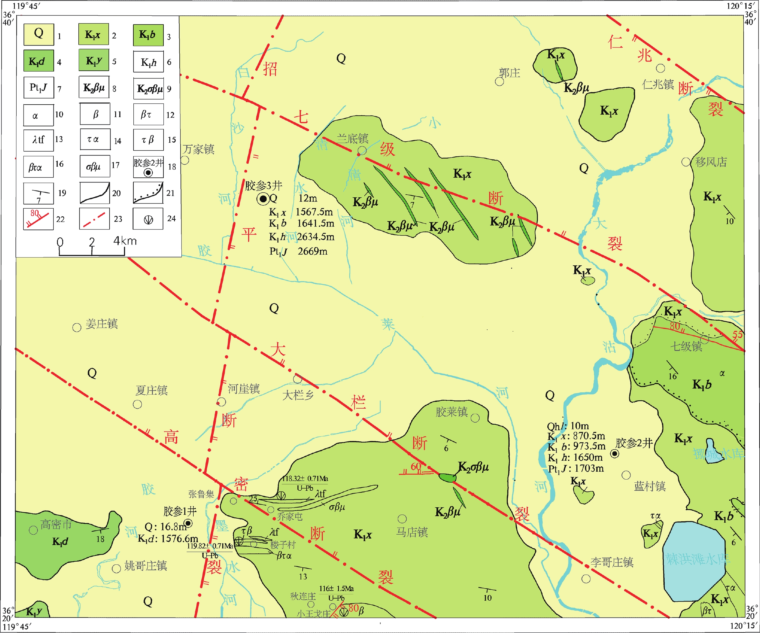
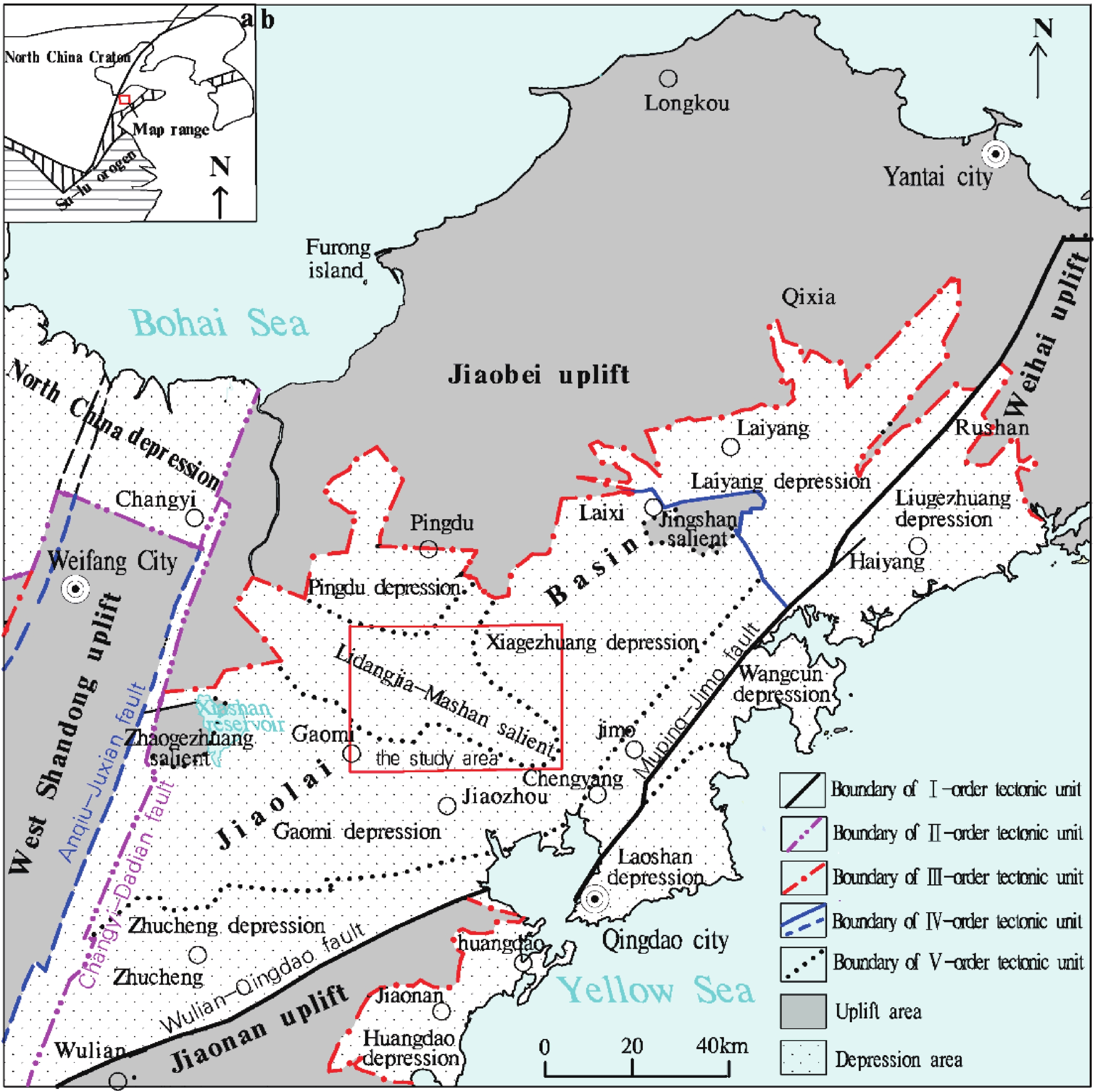
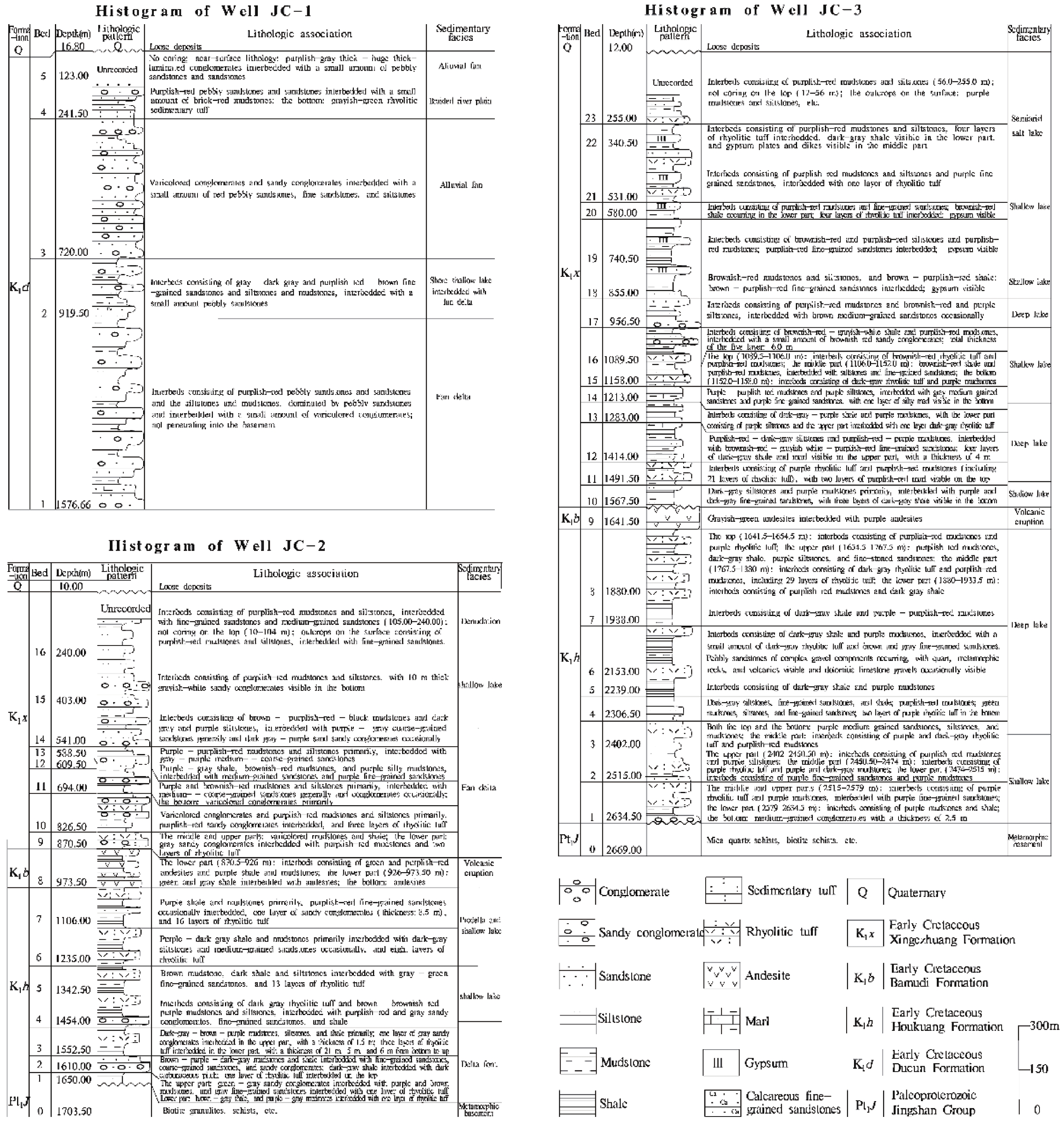
山东省万家—蓝村地区位于胶莱盆地, 夹于莱阳凹陷和诸城凹陷之间。依托2016年中国地质调查局“山东1∶50 000万家、南村、高密、蓝村幅区域地质调查” 项目, 根据《1∶50 000覆盖区区域地质调查工作指南(试行)》、《1∶50 000区域地质调查工作指南(试行)》的统一标准及要求, 在充分利用以往地质资料的基础上, 采用数字填图系统进行野外地质填图, 并应用室内与室外填编图相结合的方法, 完成标准的1∶50 000地质图及说明书编制, 建立了山东省万家镇幅(J50E021024)、南村镇幅(J51E021001)、高密市幅(J50E022024)、蓝村镇幅(J51E022001)1∶50 000数字地质图空间数据库。本数据库针对早白垩世莱阳群杨家庄组、杜村组, 青山群八亩地组、王氏群辛格庄组岩性填图, 首次在王氏群辛格庄组发现火山机构,并确定辛格庄组内火山岩夹层锆石U-Pb年龄为早白垩世。利用前人胶参1井、2井和3井钻孔资料, 恢复了李党家—马山凸起白垩纪岩相古地理, 建立了山东省万家—蓝村地区沉积构造格架。本数据库包含上述4个标准1∶50 000图幅地质图, 数据量约为22.3 MB, 于胶莱盆地火山岩中取得LA-ICP-MS锆石U-Pb同位素年龄值3个,第四系中取得光释光年龄值3个,14C同位素年龄值4个。坐标系为CGCS2000国家大地坐标系, 投影方式为高斯—克吕格投影。本数据库充分反映了1∶50 000区域地质调查成果, 为区域资源环境研究、能源勘探提供基础地质图件, 具有重要的参考意义。
Abstract:Wanjia—Lancun area in Shandong Province is located between Laiyang depression and Zhucheng depression in Jiaolai Basin. The spatial database of 1∶50 000 digital geological maps of Wanjia Town (J50E021024), Nancun Town (J51E021001), Gaomi City (J50E022024), and Lancun Town (J51E022001) map sheets, Shandong Province (also referred to as the Database) was established according to the unified standards and requirements of the ‘Guidelines for 1∶50 000-Scale Regional Geological Survey in Quaternary Coverage Area (Trial)’ and the ‘Guidelines for 1∶50 000-Scale Regional Geological Survey (Trial)’ by relying on the project titled ‘1∶50 000-Scale Regional Geological Survey of Wanjia Town, Nancun Town, Gaomi City, and Lancun Town Map Sheets, Shandong Province’ initiated by the China Geological Survey in 2016. During development of the Database, previous geological data were fully utilized, a digital mapping system was adopted for field geological mapping, and standard 1∶50 000 geological maps and work instructions were developed by means of indoor map preparation combined with field geological mapping. The aim of the Database is to complete the lithologic mapping of early Cretaceous strata, including Yangjiazhuang Formation and Ducun Formation of Laiyang Group, Bamudi Formation of Qingshan Group, and Xingezhuang Formation of Wangshi Group. A volcanic edifice was discovered for the first time in Xingezhuang Formation of Wangshi Group, and the zircon U–Pb ages of volcanic intercalations in Xingezhuang Formation were determined to be early Cretaceous. The paleogeographic characteristics of Cretaceous lithofacies of Lidangjia—Mashan dome was restored according to the previous drilling data of Well JC–1, Well JC–2 and Well JC–3. Furthermore, the sedimentary tectonic framework of Wanjia—Lancun area was established. The database contains four standard 1∶50 000 geological maps, with a data size of about 22.3 MB. LA-ICP-MS zircon U–Pb isotopic ages of three volcanic rocks, and three optically stimulated luminescence (OSL) datings and four 14C isotopic ages of Quaternary were obtained in Jiaolai Basin The maps were prepared under the CGCS2000 national geodetic coordinate system and Gauss-Kruger projection. The Database fully reflects the results of 1∶50 000-scale regional geological survey and will provide basic geological maps for research, environment and energy exploration in Wanjia—Lancun area, and therefore, is of great significance.
-

-

图 1 山东胶莱盆地万家—蓝村地区大地构造位置图(修改自张增奇等, 2014)
表 1 数据库(集)元数据简表
条目 描述 数据库(集)名称 山东省万家镇幅(J50E021024)、南村镇幅(J51E021001)、高密市幅(J50E022024)、蓝村镇幅(J51E02 2001)1∶50 000数字地质图空间数据库 数据库(集)作者 徐伟祥, 山东省第四地质矿产勘查院
高美霞, 山东省第四地质矿产勘查院
张德明, 山东省第四地质矿产勘查院
胡 冰, 山东省第四地质矿产勘查院
张 恺, 山东省潍坊基础工程公司数据时间范围 2016.07—2018.12 地理区域 地理坐标: 东经 119°45′~120°15′, 北纬 36°20′~36°40′ 数据格式 MapGIS 6.7矢量格式(*.wt, *.wl, *.wp), *.msi 数据量 22.3 MB 数据服务系统网址 http: //dcc.cgs.gov.cn 基金项目 中国地质调查局地质调查项目“山东1∶50 000万家、南村、高密、蓝村幅区域地质调查”(项目编号: DD20160044-4)资助 语种 中文 数据库(集)组成 本数据库由MapGIS格式的万家镇幅、南村镇幅、高密市幅和蓝村镇幅等4幅区域地质图库组成。每幅地质图库均包括主图、镶图和图饰图例组成。主图主要包括地质体面实体、地质(界)线、产状、火山口、同位素测年、河湖海水库岸线、火山岩相带、标准图框(内图框)、地质代号、产状注记、地质引线、同位素注记等。镶图包括综合地层柱状剖面图、主图地质剖面图、大地构造图、李党家-马山古凸起沉积断面图、重要钻孔柱状图、大地电磁测深断面图、岩相古地理图、第四系等厚度线图及古河道分布图、构造纲要图、地层格架图、火山机构示意图等。图饰图例包括主图图例、各镶图图例、接图表、责任表及中国地质调查局局徽及图幅索引  下载: 导出CSV
表 2 山东省万家镇幅、南村镇幅、高密市幅、蓝村镇幅 1∶50 000地质图空间数据库测试分析数据表
数据类型 数据量/个 数据基本特征 锆石U–Pb同位素年龄数据 3 火山岩LA–ICP–MS锆石U–Pb同位素年龄 光释光年龄数据 3 更新世黄土光释光(OSL)年龄 14C同位素年龄数据 4 全新世炭质粘土14C同位素年龄
下载: 导出CSV
Table 1. Metadata Table of Database (Dataset)
Items Description Database (dataset) name Spatial Database of 1∶50 000 Digital Geological Maps of Wanjia Town (J50E021024), Nancun Town (J51E021001), Gaomi City (J50E02 2024) and Lancun Town (J51E02 2001) Map-sheets, Shandong Province Database (dataset) authors Xu Weixiang, Shandong Provincial No.4 Institute of Geological and Mineral Survey
Gao Meixia, Shandong Provincial No.4 Institute of Geological and Mineral Survey
Zhang Deming, Shandong Provincial No.4 Institute of Geological and Mineral Survey
Hu Bing, Shandong Provincial No.4 Institute of Geological and Mineral Survey
Zhang Kai, Weifang Foundation Engineering Corporation, ShandongData acquisition time 2016.07–2018.12 Geographic area 119°45′–120°15′ E, 36°20′–36°40′ N Data format MapGIS 6.7; vector formats (*.wt, *.wl, *.wp), *.msi Data size 299 MB Data service system URL http://dcc.cgs.gov.cn Fund project The project titled 1∶50 000-Scale Regional Geological Survey of Wanjia Town, Nancun Town, Gaomi City, and Lancun Town Map-sheets, Shandong Province initiated by the China Geological Survey (No.: DD20160044-4) Language Chinese Database (dataset) composition The Database consists of four regional geological map libraries in MapGIS format of Wanjia Town, Nancun Town, Gaomi City and Lancun Town map-sheets. Each of these maps consists of a master map, mosaic maps, and map decorations and legends. The contents in a master map mainly include geological polygon entities; geological (boundaries) lines; attitude; craters; isotopic dates; shorelines of rivers, lakes, seas, and reservoirs; volcanic facies zones; standard map frames (inner map frame); geological labels; attitude annotation; geological leader lines; and isotope annotation. The mosaic maps include synthetic histograms, geological profiles of master maps, geotectonic maps, sedimentary cross sections of Lidangjia—Mashan dome, histograms of key boreholes, CSAMT profiles, lithofacies paleogeographic maps, the Quaternary isopach maps, paleochannel distribution map, geological structure outline maps, stratigraphic sedimentary framework maps, and volcanic edifice diagrams. The map decorations and legends include legends of master maps, legends of mosaic maps, index map, duty table, the emblem of the China Geological Survey, and map-sheet index
下载: 导出CSV
Table 2. Test and analysis data of the spatial database of 1∶50 000 geological maps of Wanjia town, Nancun town, Gaomi city and Lancun town map-sheets, Shandong province
Data type Data volumn Basic characteristics of data Zircon U–Pb isotopic dating data 3 samples LA–ICP–MS zircon U–Pb isotopic ages of volcanic rocks Optically stimulated luminescence (OSL) dating data 3 samples OSL ages of Pleistocene loess 14C isotopic dating data 4 samples 14C isotopic ages of Holocene carbonaceous clay
下载: 导出CSV
-
[1] 安伟, 旷红伟, 柳永清, 彭楠, 许克民, 许欢, 章朋, 王克柏, 陈树清, 张艳霞. 2016. 山东诸城晚白垩世王氏群恐龙化石层碎屑锆石定年和物源示踪[J]. 地质论评, 62(2): 453−496. http://www.wanfangdata.com.cn/details/detail.do?_type=perio&id=dzlp201602019
[2] 曹珂. 2010. 中国陆相白垩系沉积特征与古地理面貌[D]. 北京: 中国地质大学.
[3] 陈清华, 宋若微, 戴俊生, 陆克政, 熊继辉. 1994. 胶莱盆地重磁资料解释与构造特征分析[J]. 地球物理学进展, 9(3): 70−79. http://www.cnki.com.cn/Article/CJFDTotal-DQWJ403.009.htm
[4] 杜圣贤, 陈军, 陈诚, 高黎明, 刘凤臣, 宋香锁, 田京祥, 张尚坤, 刘书才. 2020. 胶莱盆地胶州组生物地层及白垩系/古近系界线[J]. 地层学杂志, 44(1): 22−34. http://www.wanfangdata.com.cn/details/detail.do?_type=perio&id=dcxzz202001003
[5] 黄太岭. 2000. 胶莱盆地区域地球物理场特征及构造单元划分[J]. 山东国土资源, 16(3): 41−47. http://www.cqvip.com/Main/Detail.aspx?id=4743098
[6] 季燕南. 2010. 山东省诸城地区晚白垩世沉积环境与山东龙集群埋藏研究[D]. 北京: 中国地质大学(北京).
[7] 旷红伟, 柳永清, 董超, 彭楠, 许欢, 王宝红, 章朋, 王克柏, 陈树清, 张艳霞. 2014. 山东诸城晚白垩世恐龙化石埋藏学研究[J]. 地质学报, 88(8): 1353−1371. http://www.wanfangdata.com.cn/details/detail.do?_type=perio&id=dizhixb201408001
[8] 李桂群, 范德江. 1994. 胶莱盆地构造单元划分及其特征[J]. 青岛海洋大学学报, 24(2): 239−246. http://qikan.cqvip.com/Qikan/Article/Detail?id=1447767
[9] 李金良, 张岳桥, 柳宗泉, 任凤楼, 袁嘉音. 2007. 胶莱盆地沉积-沉降史分析与构造演化[J]. 中国地质, 34(2): 240−250. doi: 10.3969/j.issn.1000-3657.2007.02.005
[10] 李日辉, 张光威. 2001. 山东莱阳盆地早白垩世莱阳群的遗迹化石[J]. 古生物学报, 40(2): 252−261. doi: 10.3969/j.issn.0001-6616.2001.02.011
[11] 刘明渭, 张庆玉, 宋万千. 2003. 山东省白垩纪岩石地层序列与火山岩系地层划分[J]. 地层学杂志, 27(3): 247−253. doi: 10.3969/j.issn.0253-4959.2003.03.014
[12] 刘玉强. 2001. 再论胶莱盆地金矿等找矿方向—隐伏基底综合信心金成矿预测[J]. 中国地质, 28(11): 13−19. doi: 10.3969/j.issn.1000-3657.2001.11.004
[13] 吕琳, 李伟, 刘元晴, 王新峰, 马雪梅, 邓启军. 2018. 山东省莱芜市1∶50 000水文地质图数据集[J]. 中国地质, 45(S2): 39−46. doi: 10.12029/gc2018Z205
[14] 庞健峰, 丁孝忠, 韩坤英, 韩坤英, 曾勇, 陈安蜀, 张燕玲, 张庆和, 姚东升. 2017. 1∶100万中华人民共和国数字地质图空间数据库[J]. 中国地质, 44(S1): 96−104. http://www.cqvip.com/QK/90050X/2017A01/68739073504849558349484851.html
[15] 彭楠, 柳永清, 旷红伟, 许欢, 章朋, 陈军, 安伟, 王能盛. 2015. 胶莱盆地早白垩世莱阳群沉积物源及地质意义[J]. 中国地质, 42(6): 1793−1810. http://www.wanfangdata.com.cn/details/detail.do?_type=perio&id=zgdizhi201506010
[16] 彭文泉, 蒋波, 王云燕, 梁云汉, 肖广玲. 2014. 莱阳凹陷页岩气资源潜力前景分析[J]. 山东国土资源, 30(8): 7−11. doi: 10.3969/j.issn.1672-6979.2014.08.002
[17] 宋明春. 2008. 山东省大地构造单元组成、背景和演化[J]. 地质调查与研究, 30(3): 165−175. doi: 10.3969/j.issn.1672-4135.2008.03.003
[18] 宋明春, 王沛成. 2003. 山东省区域地质[M]. 济南: 山东省地图出版社, 1−970.
[19] 孙伟清, 彭文泉, 高兵艳, 张文, 王英鹏, 郝兴中. 2019. 胶莱坳陷页岩气资源潜力评价[J]. 山东国土资源, 35(3): 1−7. http://www.wanfangdata.com.cn/details/detail.do?_type=perio&id=sddz201903001
[20] 唐风华, 程日辉, 白云风, 孔庆莹. 2003. 胶莱盆地构造演化规律[J]. 世界地质, 22(3): 246−251. doi: 10.3969/j.issn.1004-5589.2003.03.006
[21] 佟彦明. 2007胶莱盆地构造演化研究[D]. 北京: 中国地质大学.
[22] 许克民, 旷红伟, 秦杰, 汪又平, 彭楠, 宁振国, 张富中, 柳永清. 2017. 山东胶莱盆地K-Pg界线新发现[J]. 中国地质, 44(1): 194−195. http://www.wanfangdata.com.cn/details/detail.do?_type=perio&id=zgdizhi201701016
[23] 徐伟祥. 2019. 胶莱盆地万家至蓝村一带白垩纪陆相“红层”火山岩锆石U-Pb年代学、地球化学特征及其地质意义[J]. 地质学报, 93(S1): 29−36. http://www.geojournals.cn/dzxbe/ch/reader/view_abstract.aspx?file_no=2019s1004&flag=1
[24] 徐伟祥, 高美霞, 张德明, 胡冰, 张恺. 2020. 山东省万家镇幅 (J50E021024)、南村镇幅 (J51E021001)、高密市幅 (J50E022024)、蓝村镇幅 (J51E022001)1∶50 000数字地质图空间数据库[DB/OL]. 地质科学数据出版系统. (2020-06-30). DOI:10.35080/data.A.2020.P15.
[25] 翟慎德. 2003. 胶莱盆地莱阳凹陷构造特征及演化[J]. 石油实验地质, 25(2): 137−142. doi: 10.3969/j.issn.1001-6112.2003.02.006
[26] 张嘉良, 王强, 蒋顺兴, 程心, 李宁, 张鑫俊, 裘锐, 汪筱林. 2017. 山东莱阳晚白垩世鸭嘴龙动物群化石特异埋藏初步研究[J]. 古生物学报, 56(2): 214−224. http://www.wanfangdata.com.cn/details/detail.do?_type=perio&id=gswxb201702008
[27] 张艳霞, 陈军, 范燕云. 2018. 山东诸城地区恐龙足迹化石研究综述[J]. 山东国土资源, 34(6): 33−40. doi: 10.3969/j.issn.1672-6979.2018.06.005
[28] 张岳桥, 李金良, 张田, 董树文, 袁嘉音. 2008. 胶莱盆地及其邻区白垩纪—古新世沉积构造演化历史及其区域动力学意义[J]. 地质学报, 82(9): 1229−1257. doi: 10.3321/j.issn:0001-5717.2008.09.007
[29] 张增奇, 张自恒, 胡树庭, 张尚坤, 王从祥, 杜圣贤, 杨斌. 2000. 山东诸城凹陷早白垩世莱阳期古地理与沉积演化[J]. 中国地质学会“九五”全国地质科技重要成果论文集, 7.
[30] 张增奇, 张成基, 王世进, 刘书才, 王来明, 杜圣贤, 宋志勇, 张尚坤, 杨恩秀, 程光锁, 刘凤臣, 陈军, 陈诚. 2014. 山东省地层侵入岩构造单元划分对比意见[J]. 山东国土资源, 30(3): 1−23. doi: 10.3969/j.issn.1672-6979.2014.03.001
[31] 周红智, 徐崇文, 张松涛, 张里斌, 张新铭. 2019. 青海都兰沟里金矿整装勘查区1∶100 000地质矿产数据集[J]. 中国地质, 46(S1): 93−104. doi: 10.12029/gc2019Z111
[32] 周建波, 韩伟, 宋明春. 2016. 苏鲁地体折返与郯庐断裂活动: 莱阳盆地中生界碎屑锆石年代学的制约[J]. 岩石学报, 32(4): 1171−1181. http://d.wanfangdata.com.cn/Periodical/ysxb98201604016
[1] An Wei, Kuang Hongwei, Liu Yongqing, Peng Nan, Xu Kemin, Xu Huan, Zhang Peng, Wang Kebai, Chen Shuqing, Zhang Yanxia. 2016. Detrital Zircon Dating and Tracing the Provenances of Dinosaur Bone Beds from the Late Cretaceous Wangshi Group in Zhucheng, Shandong[J]. Geological Review, 62(2): 453−496 (in Chinese with English abstract). http://www.wanfangdata.com.cn/details/detail.do?_type=perio&id=dzlp201602019
[2] Cao Ke. 2010. Cretaceous continental sedimentology and paleogeography in China[D].Beijing: China Uniersity of Geosciences (in Chinese with English abstract).
[3] Chen Qinghua, Song Ruowei, Dai Junsheng, Lu Kezheng, Xiong Jihui. 1994. Jiaolai basin gravitic and magnetic data interpretation and structure analysis[J]. Progress in Geophysics, 9(3): 70−79 (in Chinese with English abstract). http://en.cnki.com.cn/Article_en/CJFDTotal-DQWJ403.009.htm
[4] Du Shengxian, Chen Jun, Chen Cheng, Gao Liming, Liu Fengchen, Song Xiangsuo, Tian Jingxiang, Zhang Shangkun, Liu Shucai. 2020. Biostratigraphy of the Jiaozhou Formation in the Jiaolai Basin, Shandong, Eastern China, With Discussion of the Cretaceous-Paleogene boundary[J]. Journal of Stratigraphy, 44(1): 22−34 (in Chinese with English abstract). http://www.wanfangdata.com.cn/details/detail.do?_type=perio&id=dcxzz202001003
[5] Hang Tailing. 2000. Characteristic of regional geophysical field in Jiaolai basin and its tectonic unit division[J]. Shandong Land and Resources, 16(3): 41−47 (in Chinese with English abstract). http://en.cnki.com.cn/Article_en/CJFDTOTAL-SDDI200003008.htm
[6] Ji Yannan. 2010. Late creaaceous sedimentary environments and mass burying of Shantungosaurus (Hadrosauridae) in Zhucheng region, Shandong province (Master thesis)[D]. Beijing: China University of Geosciences (in Chinese with English abstract)
[7] Kuang Hongwei, Liu Yongqing, Dong Chao, Peng Nan, Xu Huan, Wang Baohong, Zheng Peng, Wang Kebai, Chen Shuqing, Zhang Yanxia. 2014. Research on Taphonomy of Late Cretaceous Dinosaurs in Zhucheng, Eastern Shandong, China[J]. Acta Geologica Sinica, 88(8): 1353−137 (in Chinese with English abstract). http://www.wanfangdata.com.cn/details/detail.do?_type=perio&id=dizhixb201408001
[8] Li Guiqun, Fan Dejiang. 1994. Tectonic units division and their characteristics in the Jiaolai basin[J]. Journal of Ocean University of Qingdao, 24(2): 239−246 (in Chinese with English abstract). http://europepmc.org/abstract/CBA/271087
[9] Li Jinliang, Zhang Yueqiao, Liu Zongquan, Ren Fenglou, Yuan Jiayin. 2007. Sedimentary- subsidence history and tectonic evolution of the Jiaolai basin, eastern China[J]. Geology in China, 34(2): 240−250 (in Chinese with English abstract). http://www.wanfangdata.com.cn/details/detail.do?_type=perio&id=zgdizhi200702005
[10] Li Rihui, Zhang Guangwei. 2001. A Preliminary study of nonmarine trace fossils from the Laiyang group(early Cretaceous), Laiyang basin,eastern China[J]. Acta Paleontologica Sinica, 40(02): 252−261 (in Chinese with English abstract). http://www.wanfangdata.com.cn/details/detail.do?_type=perio&id=gswxb200102011
[11] Liu Mingwei, Zhang Qingyu, Song Wanqian. 2003. Division of the cretaceous lithostratigraphic and volcanic sequences of Shandong[J]. Journal of Stratigraphy, 27(3): 247−253 (in Chinese with English abstract). http://www.wanfangdata.com.cn/details/detail.do?_type=perio&id=dcxzz200303014
[12] Liu Yuqiang. 2001. Further discussion of the direction in gold prospecting in the Jiao-Lai basin[J]. Geology in China, 28(11): 13−19 (in Chinese with English abstract). http://www.wanfangdata.com.cn/details/detail.do?_type=perio&id=zgdizhi200111004
[13] Lyu Lin, Li Wei, Liu Yuanqing, Wang Xinfeng, Ma Xuemei, Deng Qijun. 2018. Dataset of the 1:50 000 Hydrogeological Map of Laiwu City, Shandong Province[J]. Geology in China, 45(S2): 39−46. http://en.cnki.com.cn/Article_en/CJFDTotal-DIZI2018S2005.htm
[14] Pang Jianfeng, Ding Xiaozhong, Han Kunying, Zeng Yong, Chen Anshu, Zhang Yanling, Zhang Qinghe, Yao Dongsheng. 2017. The national 1∶1 000 000 geological map spatial database[J]. Geology in China, 44(S1): 8−18. http://www.wanfangdata.com.cn/details/detail.do?_type=perio&id=9002545
[15] Peng Nan, Liu Yongqing, Kuang Hongwei, Xu Huan, Zhang Peng, Chen Jun, An Wei, Wang Nengsheng. 2015. Provenance of Early Cretaceous Laiyang Group in Jiaolai Basin and its significance[J]. Geology in China, 42(6): 1793−1810 (in Chinese with English abstract). http://www.wanfangdata.com.cn/details/detail.do?_type=perio&id=zgdizhi201506010
[16] Peng Wenquan, Jiang Bo, Wang Yunyan, Liang Yunhan, Xiao Guangling. 2014. Prospects analysis on potentiality of shale gas resource in Laiyang Depression[J]. Shandong Land and Resources, 30(08): 7−11 (in Chinese with English abstract) http://www.wanfangdata.com.cn/details/detail.do?_type=perio&id=sddz201408002
[17] Song Mingchun. 2008. The Composing, Setting and Evolution of Tectonic Unitsin Shandong Province[J]. Geological Survey and Research, 30(3): 165−175 (in Chinese with English abstract). http://en.cnki.com.cn/Article_en/CJFDTOTAL-QHWJ200803004.htm
[18] Song Mingchun, Wang Peicheng. 2003. Regional Geology of Shandong Province[M].Jinan: Shandong Map Publishing Press: 1−970(in Chinese).
[19] Sun Weiqing, Peng Wenquan, Gao Bingyan, Zhang Wen, Wang Yingpeng, Hao Xingzhong. 2019. Petential Evaluation of Shale Gas Resource in Jiaolai Depression[J]. Shandong Land and Resources, 35(3): 1−7 (in Chinese with English abstract).
[20] Tang Fenghua, Cheng Rihui, Bai Yunfeng, Kong Qingying. 2003. Tectonic Evolution of the Jiaolai Basin[J]. Global Geology, 22(3): 246−251 (in Chinese with English abstract). http://en.cnki.com.cn/Article_en/CJFDTOTAL-SJDZ200303005.htm
[21] Tong Yanming. 2007. Tectonic Evolution of Jiaolai Basin[D]. Beijing: China University of Geosciences(in Chinese with English abstract)
[22] Xu Kemin, Kuang Hongwei, Qin Jie, Wang Youping, Peng Nan, Ning Zhenguo, Zhang Fuzhong, Liu Yongqing. 2017. New discovery of terrestrial K-Pg boundary from Jiaolai Basin of Shandong Province[J]. Geology in China, 44(1): 194−195 (in Chinese with English abstract). http://www.wanfangdata.com.cn/details/detail.do?_type=perio&id=zgdizhi201701016
[23] Xu Weixiang. 2019. LA-ICP-MS zircon U−Pb ages of Cretaceous continental “red layer” volcanic rocks in Wanjia—Lancun area of Jiaolai basin and their geological significance[J]. Acta Geologica Sinica, 93(sl): 29−36 (in Chinese with English abstract).
[24] Xu Weixiang, Gao Meixia, Zhang Deming, Hu Bing, Zhang Kai. 2020. Spatial Database of 1∶50 000 Digital Geological Maps of Wanjia Town (J50E021024), Nancun Town (J51E021001), Gaomi City (J50E022024), and Lancun Town (J51E022001) Map-sheets, Shandong Province [DB/OL]. Geological Science Data Press, (2020-06-30). DOI: 10.35080/data.A.2020.P15(inChinesewithEnglishabstract).
[25] Zhai Shende. 2003. Structural characteristics and evolution in the Laiyang depression of the Jiaolai basin[J]. Petroleum Geology and Experiment, 25(02): 137−142 (in Chinese with English abstract). http://www.wanfangdata.com.cn/details/detail.do?_type=perio&id=sysydz200302006
[26] Zhang Jialiang, Wang Qiang, Jiang Shunxing, Cheng Xin, Li Ning, Zhang Xinjun, Qiu Rui, Wang Xiaolin. 2017. Preliminary research on the peculiar taphonomy of the late cretaceous laiyang hadrosauroid fauna in Shandong[J]. Acta Paleontologica Sinica, 56(2): 214−224 (in Chinese with English abstract). http://www.wanfangdata.com.cn/details/detail.do?_type=perio&id=gswxb201702008
[27] Zhang Yanxia, Chen Jun, Fan Yanyun. 2018. A Review of Footprints Fossils Research in Zhucheng Area in Shandong Province[J]. Shandong Land and Resources, 34(6): 33−40 (in Chinese with English abstract). http://www.wanfangdata.com.cn/details/detail.do?_type=perio&id=sddz201806005
[28] Zhang Yueqiao, Li Jinliang, Zhangtiao, Dong Shuwen, Yuan Jiayini. 2008. Discussion on tie evidences of mesozoic lithosphere thinning and its dynamic mechanism in jiaodong area[J]. Acta Geologica Sinica, 82(09): 1229−1257 (in Chinese with English abstract). http://www.wanfangdata.com.cn/details/detail.do?_type=perio&id=ddgzyckx200104003
[29] Zhang Zengqi, Zhang Ziheng, Hu Shuting, Zhang Shangkun, Wang Congxiang, Du Shengxian, Yang Bin. 2000. Paleogeography and sedimentary evolution of early Cretaceous Laiyang period in Zhucheng Sag, Shandong Province[J]. Proceedings of important achievements of National Geological science and Technology in the ninth five-year Plan of Chinese Geological Society, 2000: 574−580(in Chinese) (in Chinese).
[30] Zhang Zengqi, Zhang Chengji, Wang Shijin, Liu Shucai, Wang Laiming, Du Shengxian, Song Zhiyong, Zhang Shangkun, Yang Enxiu, Cheng Guangsuo, Liu Fengchen, Chen Jun, Chen Cheng. 2014. Views on Classification and Contrast of Tectonic Units in Strata in Shandong Province[J]. Shandong Land and Resources, 30(3): 1−23 (in Chinese with English abstract). http://www.wanfangdata.com.cn/details/detail.do?_type=perio&id=sddz201403001
[31] Zhou Hongzhi, Xu Chongwen, Zhang Songtao, Zhang Libin, Zhang Xinming. 2019. The 1∶100 000 geological and mineral data set for the integrated exploration area of The Dulan Guli Gold Deposit, Qinghai province[J]. Geology in China, 46(S1): 93−104 (in Chinese).
[32] Zhou Jianbo, Han Wei, Song Mingchun. 2016. The exhumation of the Sulu Terrane and the forming of the Tancheng-Lujiang Fault: Evidence from detrital zircon U−Pb dating of the Mesozoic sediments of the Laiyang Basin, Central China[J]. Acta Petrologica Sinica, 32(4): 1171−1181 (in Chinese with English abstract). http://en.cnki.com.cn/Article_en/CJFDTOTAL-YSXB201604016.htm
-


图(8)
表(4)
计量
- 文章访问数: 3169
- PDF下载数: 146
- 施引文献: 0