

Dataset of Boreholes Drilled in the Coalfield of Wucaiwan Area in Eastern Margin of Junggar Basin, Xinjiang
-
摘要:
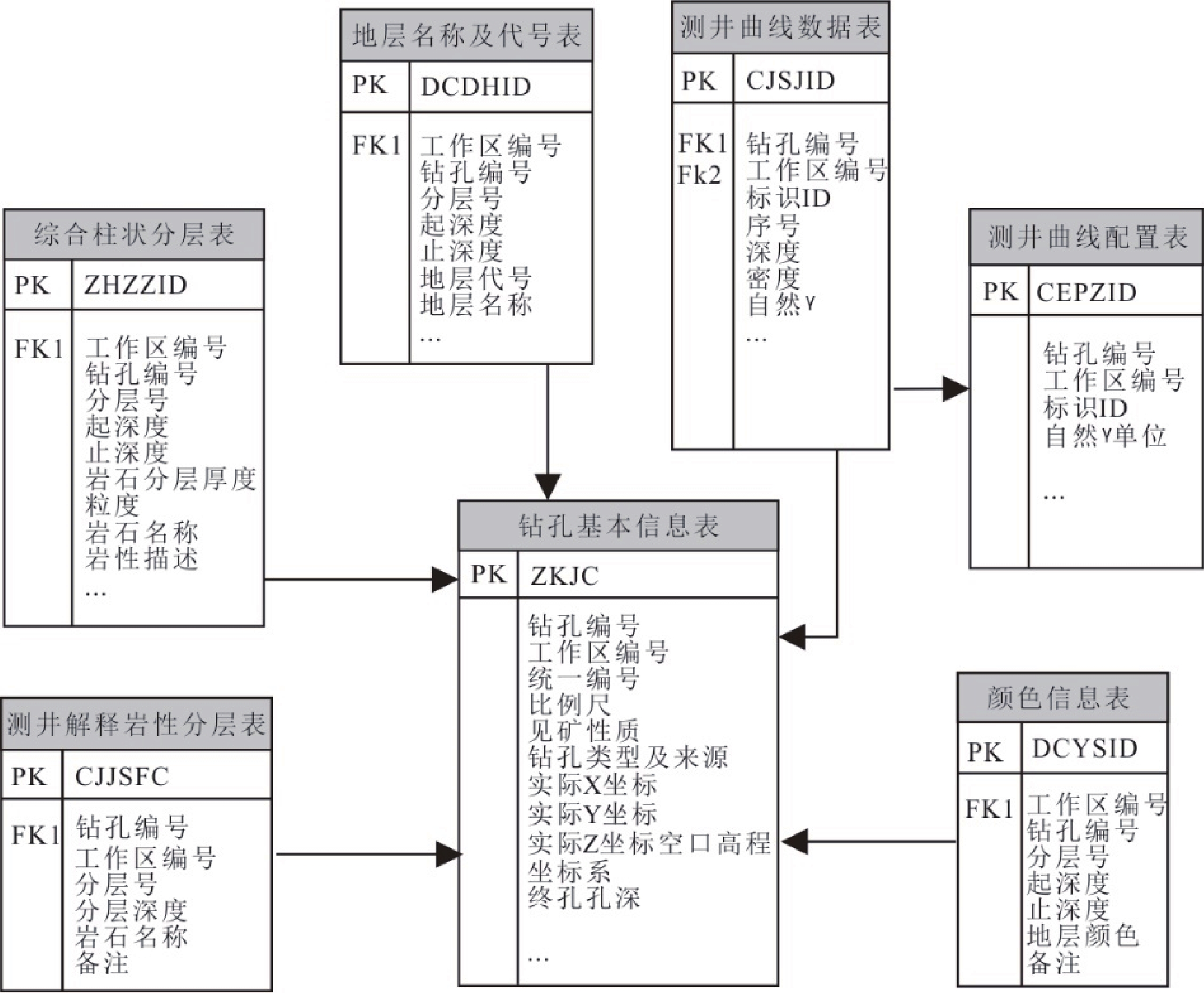
新疆准噶尔盆地是中国油气、煤炭等能源矿产的重要储集场所。本次研究对搜集到的准噶尔盆地东缘五彩湾地区20个煤田钻孔资料进行二次开发利用,通过提取钻孔坐标、高程、地层分层厚度、颜色、测井曲线解译数据等重要信息,重新建立了钻孔数据集。数据集共包含20个钻孔资料的Excel数据库型数据,每个Excel数据库由“钻孔基本信息”、“测井解释岩性分层”、“地质编录柱状分层”、“综合柱状信息”、“钻孔岩性分层”、“地层名称及代号表”、“地层颜色”、“测井曲线配置”、“测井曲线数据”、“数据字典”等10个工作表组成。利用石文软件可读取数据集信息,绘制地层沉积三维立体图,该成果能够对准噶尔盆地东缘五彩湾地区砂体的空间展布、三维地质结构等提供更加直观的认识,对研究准噶尔盆地东缘五彩湾地区的沉积环境具有重要意义。
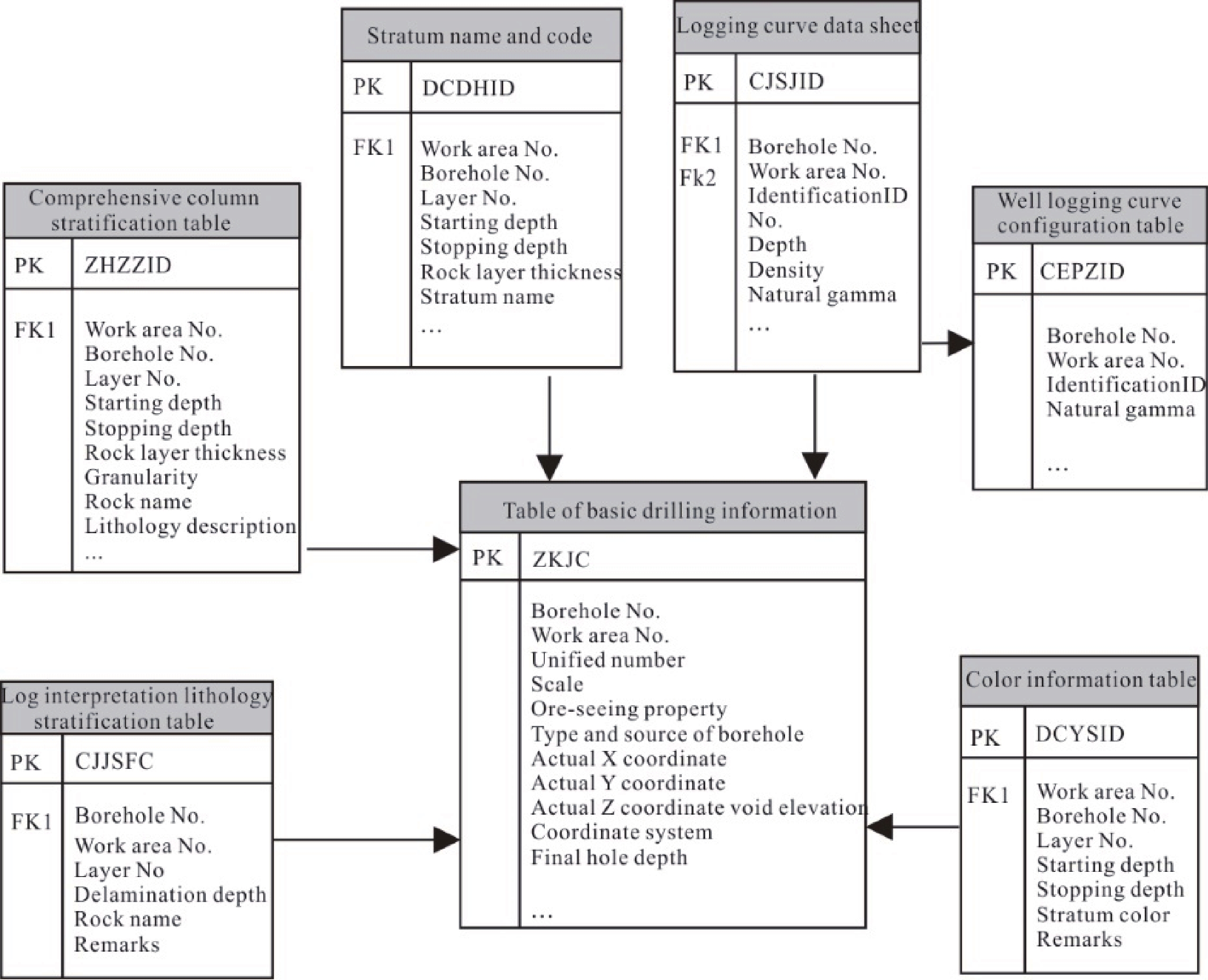
Abstract:Junggar Basin in Xinjiang is an important home to reservoirs of energy and mineral resources such as oil, gas, and coal in China. In this paper, a dataset of 20 boreholes drilled in the coalfield of Wucaiwan area that lies in the eastern margin of Junggar Basin (also referred to as the Dataset) was established based on secondary development and exploitation of existing borehole materials. In other words, the Dataset was established by extracting important information from existing materials of the boreholes such as coordinates and elevation of boreholes, thickness and color of strata discovered, and data from interpretation of logging curves. It consists of Excel database files of 20 boreholes. Each database file is comprised of 10 worksheets, namely Basic information of boreholes, Lithological beds based on logging interpretation, Beds based on geological record histogram, Beds based on comprehensive histogram, Lithological beds of boreholes, Names and codes of strata, Colors of beds, Configuration oflogging curves, Data from logging curves, and Data dictionary. The data in the Dataset can be read using software developed by Xi'an Shiwen Software Co., Ltd. (also referred to as Shiwen software) to plot 3D stereograms of stratigraphic sedimentary. This will help achieve a more intuitive understanding of the spatial distribution and 3D geological structures of sandstone bodies in Wucaiwan area and thus is significant for the research of the sedimentary environment in this area.
-
Key words:
- Junggar Basin /
- Wucaiwan area /
- boreholes drilled in coalfield /
- sedimentary strata /
- Dataset
-

-
表 1 数据库(集)元数据简介
条目 描述 数据库(集)名称 新疆准噶尔盆地东缘五彩湾地区煤田钻孔数据集 数据库(集)作者 程先钰,中国地质调查局天津地质调查中心
张天福,中国地质调查局天津地质调查中心数据时间范围 2019年 地理区域 新疆维吾尔自治区昌吉回族自治州吉木萨尔县五彩湾 数据格式 .xls 数据量 8.94 MB 数据服务系统网址 http://dcc.cgs.gov.cn 基金项目 天山—华北陆块铀钍等矿产资源调查项目(项目编号:DD20190813) 语种 中文 数据库(集)组成 本数据集共包含ZK001、ZK002、ZK003、ZK0101、ZK0107、ZK0108、ZK0109、ZK0201、ZK0202、ZK0203、ZK0204、ZK0205、ZK0206、ZK0207、ZK0208、ZK0209、ZK0210、ZK0301、ZK0306、ZK0307等20个钻孔资料的Excel数据库型数据,每个Excel数据库内包含有10个工作表,分别为“钻孔基本信息”、“测井解释岩性分层”、“地质编录柱状分层”、“综合柱状信息”、“钻孔岩性分层”、“地层名称及代号表”、“地层颜色”、“测井曲线配置”、“测井曲线数据”、“数据字典”  下载: 导出CSV
表 2 钻孔基本信息表(TABLE_ZKJC)
工作区编号GQBH 钻孔编号TKALA 统一编号PKIAA 比例尺BLC 见矿性质JKXZ 钻孔类型及来源ZKLX 实际X坐标TKCAF 实际Y坐标TKCAG 实际Z坐标/孔口高程TKCAI 坐标系ZBX 终孔孔深/m
TKACCADD20190813-3 ZK001 DD20190813-3ZK001 1∶500 2 1 4958552.446 30420439.933 484.755 西安1980 420.42
下载: 导出CSV
表 3 测井解释岩性分层表(TABLE_CJJSFC)
工作区编号
GQBH钻孔编号
TKALA分层号
GGON分层深度/m
MDBFND岩石名称
YSEBDD20190813-3 ZK001 1 37.16 砾岩 DD20190813-3 ZK001 2 52.64 泥岩 DD20190813-3 ZK001 3 184.05 粉砂岩 DD20190813-3 ZK001 4 232.21 细砂岩 DD20190813-3 ZK001 5 276.47 粉砂岩 DD20190813-3 ZK001 6 277.10 砾岩 DD20190813-3 ZK001 7 283.01 泥岩 DD20190813-3 ZK001 8 293.76 泥质粉砂岩 DD20190813-3 ZK001 9 298.05 中砂岩 DD20190813-3 ZK001 10 307.29 粉砂质泥岩
下载: 导出CSV
表 4 综合柱状分层表(TABLE_ZHZZFC)
工作区编号
GQBH钻孔编号TKALA 分层号GGON 起深度/m
TKYXQ止深度/m
TKYXZ岩石分层厚度/m
YSFCHD粒度YXLD 岩石名称
YSEB岩性描述YXMS DD20190813-3 ZK001 1 0.00 37.16 37.16 砾 砾岩 砾岩 DD20190813-3 ZK001 2 37.16 52.64 15.48 泥 泥岩 泥岩 DD20190813-3 ZK001 3 52.64 184.05 131.41 粉砂 粉砂岩 粉砂岩 DD20190813-3 ZK001 4 184.05 232.21 48.16 细砂 细砂岩 细砂岩 DD20190813-3 ZK001 5 232.21 276.47 44.26 粉砂 粉砂岩 粉砂岩 DD20190813-3 ZK001 6 276.47 277.10 0.63 砾 砾岩 砾岩 DD20190813-3 ZK001 7 277.10 283.01 5.91 泥 泥岩 泥岩 DD20190813-3 ZK001 8 283.01 293.76 10.75 粉砂 泥质粉砂岩 泥质粉砂岩 DD20190813-3 ZK001 9 293.76 298.05 4.29 中砂 中砂岩 中砂岩 DD20190813-3 ZK001 10 298.05 307.29 9.24 泥 粉砂质泥岩 粉砂质泥岩
下载: 导出CSV
表 5 地层名称及代号表(TABLE_DCDH)
工作区编号GQBH 钻孔编号TKALA 分层号GGON 起深度/m
TKDCQ止深度/m
TKDCZ地层代号DCDHDSBF 岩石地层单位名称
DSBFDD20190813-3 ZK001 1 0.00 37.16 Q 第四系 DD20190813-3 ZK001 2 37.16 52.64 N#-2#=d 独山子组 DD20190813-3 ZK001 3 52.64 277.10 K#-1#=tg 吐谷鲁群 DD20190813-3 ZK001 4 227.10 333.27 J#-2-3#=sh 石树沟群
下载: 导出CSV
表 6 地层颜色表(TABLE_DCYS)
工作区编号
GQBH钻孔编号
TKALA分层号
GGON起深度/m
TKYSQ止深度/m
TKYSZ地层颜色
YSHBDD20190813-3 ZK001 1 0.00 37.16 灰黄 DD20190813-3 ZK001 2 37.16 52.64 砖红 DD20190813-3 ZK001 3 52.64 184.05 红褐 DD20190813-3 ZK001 4 184.05 232.21 灰绿 DD20190813-3 ZK001 5 232.21 276.47 红褐 DD20190813-3 ZK001 6 276.47 277.10 褐 DD20190813-3 ZK001 7 277.10 283.01 紫红 DD20190813-3 ZK001 8 283.01 293.76 紫红 DD20190813-3 ZK001 9 293.76 298.05 灰绿 DD20190813-3 ZK001 10 298.05 307.29 紫红
下载: 导出CSV
表 7 测井曲线配置表(TABLE_CJQXPZ)
工作区编号/GQBH 钻孔编号/TKALA 标示ID/PRECID 自然γ单位/ZRGMDW DD20190813-3 ZK001 1 API
下载: 导出CSV
表 8 测井曲线数据表(TABLE_CJQXSJ)
工作区编号/GQBH 钻孔编号/TKALA 标示ID/PRECID 序号/GGON 深度/DMZKSD 自然γ/ZRGM DD20190813-3 ZK001 1 1 0.3500 18.67 DD20190813-3 ZK001 1 2 0.4000 19.05 DD20190813-3 ZK001 1 3 0.4500 19.94 DD20190813-3 ZK001 1 4 0.5000 20.25 DD20190813-3 ZK001 1 5 0.5500 20.25 DD20190813-3 ZK001 1 6 0.6000 20.13 DD20190813-3 ZK001 1 7 0.6500 19.56 DD20190813-3 ZK001 1 8 0.7000 18.67 DD20190813-3 ZK001 1 9 0.7500 18.10 DD20190813-3 ZK001 1 10 0.8000 17.27
下载: 导出CSV
Table 1. Metadata Table of Database (Dataset)
Items Description Database (dataset) name Dataset of Boreholes Drilled in the Coalfield of Wucaiwan Area in Eastern Margin of Junggar Basin, Xinjiang Database (dataset) authors Cheng Xianyu, Tianjin Center, China Geological Survey
Zhang Tianfu, Tianjin Center, China Geological SurveyData acquisition time 2019 Geographical area Wucaiwan Town, Jimsar County, Changji Hui Autonomous Prefecture, Xinjiang Uygur Autonomous Region Data format *.xls Data size 8.94 MB Data service system URL http://dcc.cgs.gov.cn Fund projects Project to Survey Mineral Resources Such as Uranium and Thorium in Tianshan-North China Continental Block (No.: DD20190813) Language Chinese Database (dataset) composition The Dataset consists of Excel database files of 20 boreholes with numbers of ZK001, ZK002, ZK003, ZK0101, ZK0107, ZK0108, ZK0109, ZK0201, ZK0202, ZK0203, ZK0204, ZK0205, ZK0206, ZK0207, ZK0208, ZK0209, ZK0210, ZK0301, ZK0306, and ZK0307. Each of these files is comprised of 10 worksheets, namely Basic information of boreholes, Lithological beds based on logging interpretation, Beds based on geological record histogram, Beds based on comprehensive histogram, Lithological beds of boreholes, Names and codes of strata, Colors of beds, Configuration of logging curves, Data from logging curves, and Data dictionary.
下载: 导出CSV
Table 2. Basic information of boreholes (TABLE_ZKJC)
Work area
No.Borehole
No.Uniform
No.Scale Ore-discovery
propertyBorehole type
and sourceActual X
coordinateActual Y
coordinateActual Z
coordinate/
borehole head
elevationCoordinate
systemFinal hole
depth/mGQBH TKALA PKIAA BLC JKXZ ZKLX TKCAF TKCAG TKCAI ZBX TKACCA DD20190813-3 ZK001 DD20190813-3ZK001 1∶500 2 1 4958552.446 30420439.933 484.755 Xi’an 1980 420.42
下载: 导出CSV
Table 3. Lithological beds based on logging interpretation (TABLE_CJJSFC)
Work area No. Borehole No. Bed No. Bed depth/m Rock name GQBH TKALA GGON MDBFND YSEB DD20190813-3 ZK001 1 37.16 Conglomerate DD20190813-3 ZK001 2 52.64 Mudstone DD20190813-3 ZK001 3 184.05 Siltstone DD20190813-3 ZK001 4 232.21 Fine sandstone DD20190813-3 ZK001 5 276.47 Siltstone DD20190813-3 ZK001 6 277.10 Conglomerate DD20190813-3 ZK001 7 283.01 Mudstone DD20190813-3 ZK001 8 293.76 Argillaceous siltstone DD20190813-3 ZK001 9 298.05 Medium sandstone DD20190813-3 ZK001 10 307.29 Silty mudstone
下载: 导出CSV
Table 4. Beds based on comprehensive histogram (TABLE_ZHZZFC)
Work area No. Borehole No. Bed No. Start depth/m End depth/m Bed thickness/m Constituent particle Rock name Lithological description GQBH TKALA GGON TKYXQ TKYXZ YSFCHD YXLD YSEB YXMS DD20190813-3 ZK001 1 0.00 37.16 37.16 Gravel Conglomerate Conglomerate DD20190813-3 ZK001 2 37.16 52.64 15.48 Mud Mudstone Mudstone DD20190813-3 ZK001 3 52.64 184.05 131.41 Silty sand Siltstone Siltstone DD20190813-3 ZK001 4 184.05 232.21 48.16 Fine sand Fine sandstone Fine sandstone DD20190813-3 ZK001 5 232.21 276.47 44.26 Silty sand siltstone siltstone DD20190813-3 ZK001 6 276.47 277.10 0.63 Gravel Conglomerate Conglomerate DD20190813-3 ZK001 7 277.10 283.01 5.91 Mud mudstone mudstone DD20190813-3 ZK001 8 283.01 293.76 10.75 Silty sand argillaceous siltstone argillaceous siltstone DD20190813-3 ZK001 9 293.76 298.05 4.29 Medium sand Medium sandstone Medium sandstone DD20190813-3 ZK001 10 298.05 307.29 9.24 Mud Silty mudstone Silty mudstone
下载: 导出CSV
Table 5. Names and codes of strata (TABLE_DCDH)
Work area
No.Borehole No. Stratum No. Start depth/m End depth/m Stratum code Name of lithostratigraphic unit GQBH TKALA GGON TKDCQ TKDCZ DCDH DSBF DD20190813-3 ZK001 1 0.00 37.16 Q Quaternary DD20190813-3 ZK001 2 37.16 52.64 N#-2#=d Dushanzi Formation DD20190813-3 ZK001 3 52.64 277.10 K#-1#=tg Tugulu Group DD20190813-3 ZK001 4 227.10 333.27 J#-2-3#=sh Shishugou Group
下载: 导出CSV
Table 6. Colors of beds (TABLE_DCYS)
Work area No. Borehole No. Bed No. Start depth/m End depth/m Bed color GQBH TKALA GGON TKYSQ TKYSZ YSHB DD20190813-3 ZK001 1 0.00 37.16 Grayish yellow DD20190813-3 ZK001 2 37.16 52.64 Brick red DD20190813-3 ZK001 3 52.64 184.05 Rufous DD20190813-3 ZK001 4 184.05 232.21 Grayish green DD20190813-3 ZK001 5 232.21 276.47 Rufous DD20190813-3 ZK001 6 276.47 277.10 Brown DD20190813-3 ZK001 7 277.10 283.01 Amaranthine DD20190813-3 ZK001 8 283.01 293.76 Amaranthine DD20190813-3 ZK001 9 293.76 298.05 Grayish green DD20190813-3 ZK001 10 298.05 307.29 Amaranthine
下载: 导出CSV
Table 7. Configuration of logging curves (TABLE_CJQXPZ)
Work area No./GQBH Borehole No./TKALA ID/PRECID Gamma ray unit/ZRGMDW DD20190813-3 ZK001 1 API
下载: 导出CSV
Table 8. Data from logging curves (TABLE_CJQXSJ)
Work area
No./GQBHBorehole
No./TKALAID/
PRECIDCode/
GGONDepth/
DMZKSDGamma ray
intensity/ZRGMDD20190813-3 ZK001 1 1 0.3500 18.67 DD20190813-3 ZK001 1 2 0.4000 19.05 DD20190813-3 ZK001 1 3 0.4500 19.94 DD20190813-3 ZK001 1 4 0.5000 20.25 DD20190813-3 ZK001 1 5 0.5500 20.25 DD20190813-3 ZK001 1 6 0.6000 20.13 DD20190813-3 ZK001 1 7 0.6500 19.56 DD20190813-3 ZK001 1 8 0.7000 18.67 DD20190813-3 ZK001 1 9 0.7500 18.10 DD20190813-3 ZK001 1 10 0.8000 17.27
下载: 导出CSV
-
[1] Li M, Shao LY, Lu J, Spiro B, Wen HJ, Li YH. 2014. Sequence stratigraphy and paleogeography of the Middle Jurassic coal measures in the Yuqia coalfield, northern Qaidam basin, northwestern China[J]. Aapg Bulletin, 98(12): 2531−2550. doi: 10.1306/06041413129
[2] Wang T, Shao LY, Tian Y, Lu J, Wang WL. 2012. Sequence stratigraphy of the Jurassic coal measures in northwestern China[J]. Acta Geologica Sinica (English Edition), 86(3): 769−778. doi: 10.1111/j.1755-6724.2012.00702.x
[3] 鲍志东, 赵艳军, 祁利祺, 司敏娜, 吴博然, 罗小玉, 赵华, 伍星. 2011. 构造转换带储集体发育的主控因素——以准噶尔盆地腹部侏罗系为例[J]. 岩石学报, 27(3): 867−877. http://www.wanfangdata.com.cn/details/detail.do?_type=perio&id=ysxb98201103023
[4] 陈发景, 汪新文, 汪新伟. 2005. 准噶尔盆地的原型和构造演化[J]. 地学前缘, 12(3): 77−89. doi: 10.3321/j.issn:1005-2321.2005.03.010
[5] 程先钰, 张天福. 2020. 新疆准噶尔盆地东缘五彩湾地区煤田钻孔数据集[DB/OL]. 地质科学数据出版系统. (2020-06-30). DOI: 10.35080/data.H.2020.P19.
[6] 冯晓曦, 滕雪明, 何友宇. 2019. 初步探讨鄂尔多斯盆地东胜铀矿田成矿作用研究若干问题[J]. 地质调查与研究, 42(2): 96−108. doi: 10.3969/j.issn.1672-4135.2019.02.003
[7] 韩守华, 李娴静, 陈能贵, 沈金龙, 徐洋. 2012. 准噶尔盆地南缘中段下组合储层特征及控制因素分析[J]. 沉积与特提斯地质, 32(4): 52−58. doi: 10.3969/j.issn.1009-3850.2012.04.008
[8] 阮传明, 刘丽, 张军, 等. 2008. 新疆准东煤田吉木萨尔县五彩湾(天隆)露天矿勘探报告[R]. 新疆地矿局第九地质大队.
[9] 孙巧银, 方磊, 王化齐. 2018. 银川盆地1∶50 000芦花台幅工程地质钻孔及取样土工试验数据集[J]. 中国地质, 46(S2): 56−61. doi: 10.12029/gc2018Z207
[10] 孙巧银, 李成柱, 方磊. 2019. 2017年银川盆地1∶50 000平罗站幅工程地质钻孔及取样土工试验数据集[J]. 中国地质, 46(S1): 32−38. doi: 10.12029/gc2019Z104
[11] 汤超, 金若时, 谷社峰, 李建国, 钟延秋, 苗培森, 司马献章, 魏佳林. 2018. 松辽盆地北部四方台组工业铀矿体的发现及其意义[J]. 地质调查与研究, 41(1): 1−32. doi: 10.3969/j.issn.1672-4135.2018.01.001
[12] 魏佳林, 汤超, 徐增连, 肖鹏, 刘华健, 曾辉, 陈路路, 赵丽君, 郭虎, 张超, 朱强, 李艳锋. 2018. 大庆长垣南部四方台组砂岩型铀矿化特征研究[J]. 地质调查与研究, 41(1): 9−17. doi: 10.3969/j.issn.1672-4135.2018.01.002
[13] 杨有星, 金振奎, 时晓章. 2010. 准噶尔盆地西北缘检188井区下侏罗统八道湾组沉积特征及主控因素分析[J]. 沉积与特提斯地质, 30(4): 38−49. doi: 10.3969/j.issn.1009-3850.2010.04.006
[14] 张天福, 孙立新, 张云, 程银行, 李艳峰, 马海林, 鲁超, 杨才, 郭根万. 2016. 鄂尔多斯盆地北缘侏罗纪延安组、直罗组泥岩微量元素、稀土元素地球化学特征及其古沉积环境意义[J]. 地质学报, 90(12): 3454−3472. doi: 10.3969/j.issn.0001-5717.2016.12.013
[15] 张天福, 张云, 苗培森, 俞礽安, 李建国, 金若时, 孙立新. 2018. 鄂尔多斯盆地西缘中晚侏罗世地层化学蚀变指数(CIA)研究及其意义[J]. 地质调查与研究, 41(4): 258−262. doi: 10.3969/j.issn.1672-4135.2018.04.002
[16] 张天福, 张云, 程银行, 苗培森, 奥琮, 金若时, 段连峰, 段宵龙. 2019. 利用露头、井震及地球化学综合厘定层序界面—以鄂尔多斯盆地东北缘侏罗系为例[J]. 煤田地质与勘探, 47(1): 40−48. doi: 10.3969/j.issn.1001-1986.2019.01.006
[17] 周小希, 陈安蜀, 邓凡, 杨君, 王心华. 2016. 北方重要盆地铀矿钻孔数据库设计及实现[J]. 地质调查与研究, 39(3): 231−236. doi: 10.3969/j.issn.1672-4135.2016.03.012
[1] Bao Zhidong, Zhao Yanjun, Qi Liqi, Si Minna, Wu Boran, Luo Xiaoyu, Zhao Hua and Wu Xin. 2011. Controlling factors of reservoir development in structural transfer zones: A case study of the Inner Junggar basin in Jurassic[J]. Acta Petrologica Sinica, 27(3): 867−877 (in Chinese with English abstract). http://en.cnki.com.cn/Article_en/CJFDTOTAL-YSXB201103024.htm
[2] Chen Fajing, Wang Xinwen, Wang Xinwei. 2005. Prototype and tectonic evolution of the Junggar basin. northwestern China[J]. Earth Science Frontiers, 12(3): 77−89 (in Chinese with English abstract). http://www.researchgate.net/publication/303918747_Prototype_and_tectonic_evolution_of_the_Junggar_Basin_Northwestern_China
[3] Cheng Xianyu, Zhang Tianfu. 2020. Dataset of boreholes drilled in the coalfield of Wucaiwan area in eastern margin of Junggar Basin, Xinjiang[DB/OL]. Geoscientific Data & Discovery Publishing System. (2020–06–30). DOI: 10.35080/data.H.2020.P19.
[4] Feng Xiaoxi, Teng Xueming, He Youyu. 2019. Preliminary discussions on the metallogenesis of the Dongshenguranium orefields in the Ordos basin[J]. Geological Survey and Research, 42(2): 96−108 (in Chinese with English abstract). http://en.cnki.com.cn/Article_en/CJFDTotal-QHWJ201902003.htm
[5] Han Shouhua, LiI Xianjing, Chen Nenggui, Shen Jinlong, Xu Yang. 2012. Hydrocarbon reservoirs and their controlling factors in the lower associations of the middle part of southern Junggar Basin, Xinjiang[J]. Sedimentary Geology and Tethyan Geology, 32(4): 52−58 (in Chinese with English abstract). http://www.wanfangdata.com.cn/details/detail.do?_type=perio&id=yxgdl201204008
[6] Li Meng, Shao Longyi, Lu Jing, Spiro Baruch, Wen Huaijun, Li Yonghong. 2014. Sequence stratigraphy and paleogeography of the Middle Jurassic coal measures in the Yuqia coalfield, northern Qaidam basin, northwestern China[J]. APG Bulletin, 98(12): 2531−2550. doi: 10.1306/06041413129
[7] Ruan Chuanming, Liu Li, Zhang Jun, et al.2008. Exploration report of Wucaiwan (Tianlong) open pit mine, Jimusaer County, Zhundong coalfield, Xinjiang[R]. The ninth Geological Brigade of Xinjiang Bureau of Geology and mineral resources (in Chinese).
[8] Sun Qiaoyin, Fang Lei, Wang Huapu. 2018. Luhuatai in the Yinchuan Basin for the 1∶50 000 map: dataset from engineering geology boreholes, samples and geotechnical tests[J]. Geology in China, 45(S2): 75−82.
[9] Sun Qiaoyin, Li Chengzhu, Fang Lei. 2019. Dataset of the 1∶50 000 Pingluo Station map sheet area in the Yinchuan Basin in 2017- obtained from geological engineering drilling, borehole sampling and geotechnical tests[J]. Geology in China, 46(S1): 42−50.
[10] Tang Chao, Jin Ruoshi, Gu Shefeng, Li Jianguo, Zhong Yanqiu, Miao Peisen, SIMA Xianzhang WeiI Jialin. 2018. Discovery and significance of industrial uranium ore in SifangtaiFormation, north Songliao basin[J]. Geological Survey and Research, 41(1): 1−32 (in Chinese with English abstract). http://en.cnki.com.cn/Article_en/CJFDTotal-QHWJ201801001.htm
[11] Wang Tong, Shao Longyi, Tian Ye, Lu Jing, Wang Wenlong. 2012. Sequence stratigraphy of the Jurassic coal measures in northwestern China[J]. Acta Geologica Sinica (English Edition), 86(3): 769−778. doi: 10.1111/j.1755-6724.2012.00702.x
[12] Wei Jialin, Tang Chao, Xu Zenglian, Xiao Peng, Liu Huajian, Zeng Hui, Chen Lulu, Zhao Lijun, Guo Hu, Zhang Chao, Zhu Qiang, LI Yanfeng. 2018. Research on sandstone-hosted uranium mineralization of the SifangtaiFormation in southern Daqing placanticline[J]. Geological Survey and Research, 41(1): 9−17 (in Chinese with English abstract). http://en.cnki.com.cn/Article_en/CJFDTotal-QHWJ201801002.htm
[13] Yang Youxing, Jin Zhenkui, Shi Xiaozhang. 2010. Sedimentary facies and controlling factors of the Lower Jurassic Badaowan Formation in the Junggar Basin[J]. Sedimentary Geology and Tethyan Geology, 30(4): 38−49 (in Chinese with English abstract). http://www.wanfangdata.com.cn/details/detail.do?_type=perio&id=yxgdl201004006
[14] Zhang Tianfu, Sun Lixin, Zhang Yun, Cheng Yinhang, Li Yanfeng, MA Hailin, Lu Chao, Yang Cai, Guo Genwan. 2016. Geochemical Characteristics of the Jurassic Yan’an and Zhiluo Formations in the Northern Margin of Ordos Basin and Their Paleoenvironmental Implications[J]. Acta Geologica Sinica, 90(12): 3454−3472 (in Chinese with English abstract).
[15] Zhang Tianfu, Zhang Yun, Miao Peisen, Yu Rengan, Li Jianguo, Jin Ruoshi, Sun Lixin. 2018. Study on the chemical index of alteration of the Middle and Late Jurassic Strata in the western margin of Ordos basin and its implications[J]. Geological Survey and Research, 41(4): 258−262 (in Chinese with English abstract). http://www.wanfangdata.com.cn/details/detail.do?_type=perio&id=qhwjyjjz201804002
[16] Zhang Tianfu, Zhang Yun, Cheng Yinhang, Miao Peisen, Ao Cong, Jin Ruoshi, Duan Lianfeng, Duan Xiaolong. 2019. Integrated identification of sequence boundary through outcrop, seismic with logging and geochemistry: A case of Jurassic in northeastern margin of Ordos basin[J]. Coal Geology &Exploration, 47(1): 40−48 (in Chinese with English abstract).
[17] Zhou Xiaoxi, Chen Anshu, Deng Fan, Yang Jun, Wang Xinhua. 2016. Design and realization of uranium mine drilling database of the important basins in North China[J]. Geological Survey and Research, 39(3): 231−236 (in Chinese with English abstract). http://www.wanfangdata.com.cn/details/detail.do?_type=perio&id=qhwjyjjz201603012
-


图(8)
表(16)
计量
- 文章访问数: 1810
- PDF下载数: 271
- 施引文献: 0