

-
摘要:
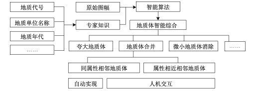
地质体综合是地质图编制工作的重中之重,因其处理涉及内容多、业务逻辑复杂、重复工作量大,是影响编图工作推进的主要因素。为了能够实现地质体的高效综合,文章提出了一种以地质约束条件(专家知识)为核心、以制图综合为空间图形合并手段的新型地质体智能综合方法,设计并实现了围绕地质专家知识(如地质年代、地层名称等)规则映射开展的三种地质体综合方法(同属性合并、交互式选择合并、绘图合并)。使用北山地区地质图数据对地质体综合模块进行测试,经反复对比实验,证实了该方法不仅能够快速实现地质体空间图形的"一键式"合并,还可以自动完成地质知识的映射与赋值,综合结果符合地质规律。该方法为反映地质空间分布前提下对图件中地质体或其他面图元的精简提供了一种有效的自动化工具。
Abstract:Due to its massive content, complex processing logic and heavy repeated workload, geologic body synthesis, as the key task in the geological map compilation, is the primary factor affecting the process. Therefore, our study aims to realize the high-efficiency synthesis of geologic bodies. This paper presents a new intelligence method of synthesizing geologic bodies, which takes geological constraints (expert knowledge) as the core and cartographic generalization as the means to merge spatial graphs. Also three ways of synthesizing geologic bodies were designed (merging geologic bodies with the same properties, merging interactively selected geologic bodies, merging geologic bodies into drawn bigger polygons) based on regular mapping of geological expert knowledge such as geological age, stratigraphic name. By using the geological map data in the Beishan area to test the geologic body merging module, and through repeated comparative experiments, it is proved that this intelligence method can not only rapidly realize the "one-click" synthesis of the spatial graphs of geologic bodies, but also complete the automatic mapping and assignment of geological knowledge. The comprehensive results accord with the geological rule. This method provides an effective automatic tool for simplifying geologic bodies or other surface elements to reflect the spatial distribution in a geological map.
-

-
AI T H, 2016. Development of cartography driven by big data[J]. Journal of Geomatics, 41(2): 1-7. (in Chinese with English abstract) http://www.researchgate.net/publication/305444281_Development_of_cartography_driven_by_big_data
CHEN Y Y, HOU D H, PAN Z L, et al., 2021. Practice of intelligent mapping of basic geological maps in typical areas: an example of 1: 250000 Tianshuijin Mapping in Beishan area[J/OL]. Geological Bulletinof China: 1-16. (2021-01-21)[2021-02-22]. http://kns.cnki.net/kcms/detail/11.4648.P.20210121.1054.004.html. (in Chinese with English abstract)
DONG P P, Li Y J, Wang G H, et al, 2021. Geological and chronological characteristics of the Baiyin' gaolao Formation in Gaoyaowula, Inner Mongolia[J]. Journal of Geomechanics, 27(1): 135-152. (in Chinese with English abstract)
HE W N, ZHU C Q, WANG Y Z, et al., 2019. iMapower: an intelligent system for geological mapping based on MapGIS[J]. Progress in Geophysics, 34(5): 2030-2036. (in Chinese with English abstract) http://en.cnki.com.cn/Article_en/CJFDTotal-DQWJ201905041.htm
HE W N, ZHU C Q, LI Y C, et al., 2020a. Intelligent geological map generalization based on ArcGIS[J]. Progress in Geophysics, 35(2): 728-734. (in Chinese with English abstract)
HE W N, ZHU C Q, LI Y C, et al., 2020b. An intelligent generalization method of geological body for MapGIS geological map downsizing[J]. Geological Bulletin of China, 39(6): 871-879. (in Chinese with English abstract)
HUANG H, LU Y M, LI Y C, et al., 2021. Technology and its Applications of geological map intelligent generalization based on the multivariate geological knowledge and model of geological mapping[J/OL]. Geological Bulletin: 1-12. (2021-01-20)[2021-02-22]. http://kns.cnki.net/kcms/detail/11.4648.P.20210120.1056.004. html. (in Chinese with English abstract)
HUANG X W, XUE Y T, ZHANG Z L, 2020. Research on BIM Technical Method of Railway Engineering Geology[J]. Railway Investigation and Surveying, 46(1): 141-143, 149. (in Chinese with English abstract)
KE X, DING X Z, HAN K Y, et al., 2008. Method for the construction of the geological map database based on MapGIS: example from the 1: 1 M geological map database of China[J]. Journal of Geomechanics, 14(2): 186-196. (in Chinese with English abstract) http://en.cnki.com.cn/Article_en/CJFDTOTAL-DZLX200802010.htm
LI L, 2018. The application and improvement of iMapower in compilating a geologic map of the scale 1: 250, 000[D]. Beijing: China University of Geosciences(Beijing). (in Chinese with English abstract)
LI T D, 2011. Status and characteristics of international geological mapping[C]//Proceedings of the National Symposium on Geological Mapping and GIS. Kunming: Geological Society of China, Geological Society of Yunnan Province: 1-11. (in Chinese with English abstract)
LI T G, 2004. The practice of book editing[M]. Beijing: Geology Press. (in Chinese)
LI Y C, 2020. Integrated intelligent mapping system for Geological Survey and its application[R]. Beijing: Development Research Center, China Geological Survey Bureau. (in Chinese with English abstract)
LI Y C, WANG Y Z, CHEN Y Y, et al., 2020. Intelligent geological mapping: A novel pattern for smart geological compilation[J]. Geological Bulletin of China, 39(6): 861-870. (in Chinese with English abstract)
LIU L G, XUE H L, YAO X C, 2011. A method to downsize land use map by using ArcGIS software[J]. Bulletin of Surveying and Mapping(9): 62-65. (in Chinese with English abstract) http://en.cnki.com.cn/Article_en/CJFDTOTAL-CHTB201109020.htm
LIU S N, LI T G, 2014. Digital geological mapping[M]. Beijing: Geology Press. (in Chinese with English abstract)
MENG X H, HU Y R, WANG Y Z, et al., 2020. A method for merging geological bodies with same attribute based on ArcGIS and geological expert knowledge[J]. Journal of Inner Mongolia University of Technology, 39(4): 273-278. (in Chinese with English abstract)
WANG J Y, 2005. Research on cartography and geographic information engineering[M]. Beijing: Science Press. (in Chinese with English abstract)
WANG J Y, QIAN H Z, 2006. Cartographic-generalization-knowledge and its application[J]. Geomatics and Information Science of Wuhan University, 31(5): 382-386, 439. (in Chinese with English abstract) http://en.cnki.com.cn/Article_en/CJFDTOTAL-WHCH200605002.htm
WANG J Y, LI Z L, WU F, 2011. Advances in digital map generalization[M]. Beijing: Science Press. (in Chinese with English abstract)
WANG J Y, SUN Q, WANG G X, et al., 2014. Principles and methods of cartography[M]. 2nd ed. Beijing: Science Press. (in Chinese with English abstract)
WANG Y G, HAO L R, HUANG H, et al., 2019. Research on geological map compilation technology based on spatial data and geological knowledge[J]. Geological Bulletin of China, 38(12): 2067-2076. (in Chinese with English abstract)
WANG Z L, ZHANG X H, WEN Z H, et al., 2012. Current status and future trend of geological map compilation[J]. Marine Geology Frontiers, 28(1): 21-29. (in Chinese with English abstract)
WENG Z P, 2013. Fast building and refreshing three-dimensional models of geological entity[D]. Wuhan: China University of Geosciences (Wuhan). (in Chinese with English abstract)
WINCHESTER S, 2002. The map that changed the world: William Smith and the birth of modern geology[M]. New York, NY: Perennial.
WU F, GONG X Y, DU J W, 2017. Overview of the research progress in automated map generalization[J]. Acta Geodaetica et Cartographica Sinica, 46(10): 1645-1664. (in Chinese with English abstract) http://www.ingentaconnect.com/content/doaj/10011595/2017/00000046/00000010/art00045
WU H H, 2012. Basic Model and Algorithm for GIS and map information synthesis[M]. Wuhan: Wuhan University Press. (in Chinese with English abstract)
XU Z G, WANG Y, CHEN Z H, et al., 2020, Mapping ideas and methods for the provincial "Mineral Geological Map" and "Minerogenic Map" in the "Geology of Mineral Resources of China"[J]. Acta Geologica Sinica, 94(1): 303-325. (in Chinese with English abstract)
YANG X C, WU Z H, ZHANG S M, et al., 2020a. Current status of geological map database and future perspectives of geological mapping[J]. Geological Journal of China Universities, 26(1): 100-110. (in Chinese with English abstract)
YANG X C, YE M N, YE P S, et al., 2020b. Information construction method of geological survey projects based on digital mapping technology[J]. Journal of Geomechanics, 26(2): 263-270. (in Chinese with English abstract)
YING S, LI L, 2003. Knowledge Representation of cartographic generalization[J]. Journal of Geomatics, 28(6): 26-28. (in Chinese with English abstract) http://en.cnki.com.cn/Article_en/CJFDTOTAL-CHXG200306010.htm
YOU J Q, LI D J, ZOU S W, 2015. Studies of small map delineation integration in map generalization[J]. Journal of Anhui Agricultural Sciences, 43(6): 354-356, 376. (in Chinese with English abstract) http://en.cnki.com.cn/Article_en/CJFDTotal-AHNY201506130.htm
ZHANG S K, NI J Y, GAO W L, et al., 2009. Study on the technology and method of 3D geological modeling: a case study ofthe east Kunlun Orogenic belt[J]. Journal of Geomechanics, 15(2): 201-208. (in Chinese with English abstract) http://www.researchgate.net/publication/285768440_Study_on_the_technology_and_method_of_3d_geological_modeling_A_case_study_of_the_east_kunlun_orogenic_belt
ZOU S W, ZOU S L, LI D J, et al., 2013. Methods improvement of small figure spot comprehensive in land use map downsizing[J]. Geospatial Information, 11(1): 138-140. (in Chinese with English abstract) http://www.zhangqiaokeyan.com/academic-journal-cn_geospatial-information_thesis/0201252807644.html
艾廷华, 2016. 大数据驱动下的地图学发展[J]. 测绘地理信息, 41(2): 1-7. https://www.cnki.com.cn/Article/CJFDTOTAL-CHXG201602002.htm
陈圆圆, 侯德华, 潘志龙, 等, 2021. 典型地区基础地质图智能编图实践: 以北山地区1: 25万甜水井幅为例[J/OL]. 地质通报: 1-16. (2021-01-21)[2021-02-22]. http://kns.cnki.net/kcms/detail/11.4648.P.20210121.1054.004.html.
董培培, 李英杰, 王根厚, 等, 2021. 内蒙古高尧乌拉白音高老组地质及年代学特征[J]. 地质力学学报, 27(1): 135-152.
何文娜, 朱长青, 王永志, 等, 2019. 智绘地质: 一种基于MapGIS的地质编图智能化系统[J]. 地球物理学进展, 34(5): 2030-2036. https://www.cnki.com.cn/Article/CJFDTOTAL-DQWJ201905041.htm
何文娜, 朱长青, 李仰春, 等, 2020a. 基于ArcGIS的智能地质图综合[J]. 地球物理学进展, 35(2): 728-734. https://www.cnki.com.cn/Article/CJFDTOTAL-DQWJ202002042.htm
何文娜, 朱长青, 李仰春, 等, 2020b. 智能地质体综合技术在地质图缩编中的应用[J]. 地质通报, 39(6): 871-879. https://www.cnki.com.cn/Article/CJFDTOTAL-ZQYD202006008.htm
黄辉, 路彦明, 李仰春, 等, 2021. 基于多元知识和编图模型的智能地质编图技术及其应用[J/OL]. 地质通报: 1-12. (2021-01-20)[2021-02-22]. http://kns.cnki.net/kcms/detail/11.4648.P.20210120.1056.004.html.
黄新文, 薛宇腾, 张忠良, 2020. 铁路工程地质BIM技术方法研究[J]. 铁道勘察, 46(1): 141-143, 149. https://www.cnki.com.cn/Article/CJFDTOTAL-TLHC202001030.htm
柯学, 丁孝忠, 韩坤英, 等, 2008. 基于MAPGIS建立地质图数据库的方法: 以全国1: 100万地质图数据库为例[J]. 地质力学学报, 14(2): 186-196. doi: 10.3969/j.issn.1006-6616.2008.02.010
李丽, 2018. iMapower在1: 25万地质编图中的应用及其改进[D]. 北京: 中国地质大学(北京).
李廷栋, 2011. 国际地质编图现状和特点[C]//全国地质制图与GIS学术论坛论文集. 昆明: 中国地质学会, 云南省地质学会: 1-11.
李铁钢, 2004. 图书编辑工作实务[M]. 北京: 地质出版社.
李仰春, 王永志, 陈圆圆, 等, 2020. 智绘地质: 新一代智能化地质编图模式及应用[J]. 地质通报, 39(6): 861-870. https://www.cnki.com.cn/Article/CJFDTOTAL-ZQYD202006007.htm
刘立国, 薛红琳, 姚新春, 2011. 浅谈借助ArcGIS软件进行土地利用现状图缩编的方法[J]. 测绘通报(9): 62-65. https://www.cnki.com.cn/Article/CJFDTOTAL-CHTB201109020.htm
刘素楠, 李通国, 2014. 数字化地质制图[M]. 北京: 地质出版社.
孟祥卉, 胡越然, 王永志, 等, 2020. 基于ArcGIS和地质专家知识的同属性合并方法[J]. 内蒙古工业大学学报, 39(4): 273-278. doi: 10.3969/j.issn.1001-5167.2020.04.005
王家耀, 2005. 地图学与地理信息工程研究[M]. 北京: 科学出版社.
王家耀, 钱海忠, 2006. 制图综合知识及其应用[J]. 武汉大学学报·信息科学版, 31(5): 382-386, 439. https://www.cnki.com.cn/Article/CJFDTOTAL-WHCH200605002.htm
王家耀, 李志林, 武芳, 2011. 数字地图综合进展[M]. 北京: 科学出版社.
王家耀, 孙群, 王光霞, 等, 2014. 地图学原理与方法[M]. 2版. 北京: 科学出版社.
王杨刚, 郝丽荣, 黄辉, 等, 2019. 基于空间数据和专家知识驱动的地质编图技术研究与应用[J]. 地质通报, 38(12): 2067-2076. https://www.cnki.com.cn/Article/CJFDTOTAL-ZQYD201912016.htm
王忠蕾, 张训华, 温珍河, 等, 2012. 地质编图研究现状及发展方向[J]. 海洋地质前沿, 28(1): 21-29. https://www.cnki.com.cn/Article/CJFDTOTAL-HYDT201201005.htm
翁正平, 2013. 复杂地质体三维模型快速构建及更新技术研究[D]. 武汉: 中国地质大学(武汉).
武芳, 巩现勇, 杜佳威, 2017. 地图制图综合回顾与前望[J]. 测绘学报, 46(10): 1645-1664. doi: 10.11947/j.AGCS.2017.20170287
毋河海, 2012. GIS与地图信息综合基本模型与算法[M]. 武汉: 武汉大学出版社.
徐志刚, 王岩, 陈郑辉, 等, 2020. 中国矿产地质志省级"矿产地质图"和"成矿规律图"的编图思路和编图方法[J]. 地质学报, 94(1): 303-325. https://www.cnki.com.cn/Article/CJFDTOTAL-DZXE202001022.htm
杨星辰, 吴珍汉, 张素梅, 等, 2020a. 地质图数据库现状与地质制图发展趋势[J]. 高校地质学报, 26(1): 100-110. https://www.cnki.com.cn/Article/CJFDTOTAL-GXDX202001009.htm
杨星辰, 叶梦旎, 叶培盛, 等, 2020b. 地质调查成果信息化建设方法探索: 基于数字填图技术[J]. 地质力学学报, 26(2): 263-270. https://www.cnki.com.cn/Article/CJFDTOTAL-DZLX202002011.htm
应申, 李霖, 2003. 制图综合的知识表示[J]. 测绘信息与工程, 28(6): 26-28. doi: 10.3969/j.issn.1007-3817.2003.06.011
游晋卿, 李大军, 邹胜武, 2015. 地图缩编中小图斑综合问题研究[J]. 安徽农业科学, 43(6): 354-356, 376. doi: 10.3969/j.issn.0517-6611.2015.06.130
张思科, 倪晋宇, 高万里, 等, 2009. 三维地质建模技术方法研究: 以东昆仑造山带为例[J]. 地质力学学报, 15(2): 201-208. doi: 10.3969/j.issn.1006-6616.2009.02.009
邹胜武, 邹时林, 李大军, 等, 2013. 土地利用图缩编中小图斑综合方法的改进[J]. 地理空间信息, 11(1): 138-140. doi: 10.3969/j.issn.1672-4623.2013.01.047
-
 下载:
下载:
图(9)
计量
- 文章访问数: 1726
- PDF下载数: 54
- 施引文献: 0