Characteristics of geological hazard development and disaster-inducing environment of the MS6.2 earthquake in Jishishan, Gansu Province
-
摘要:
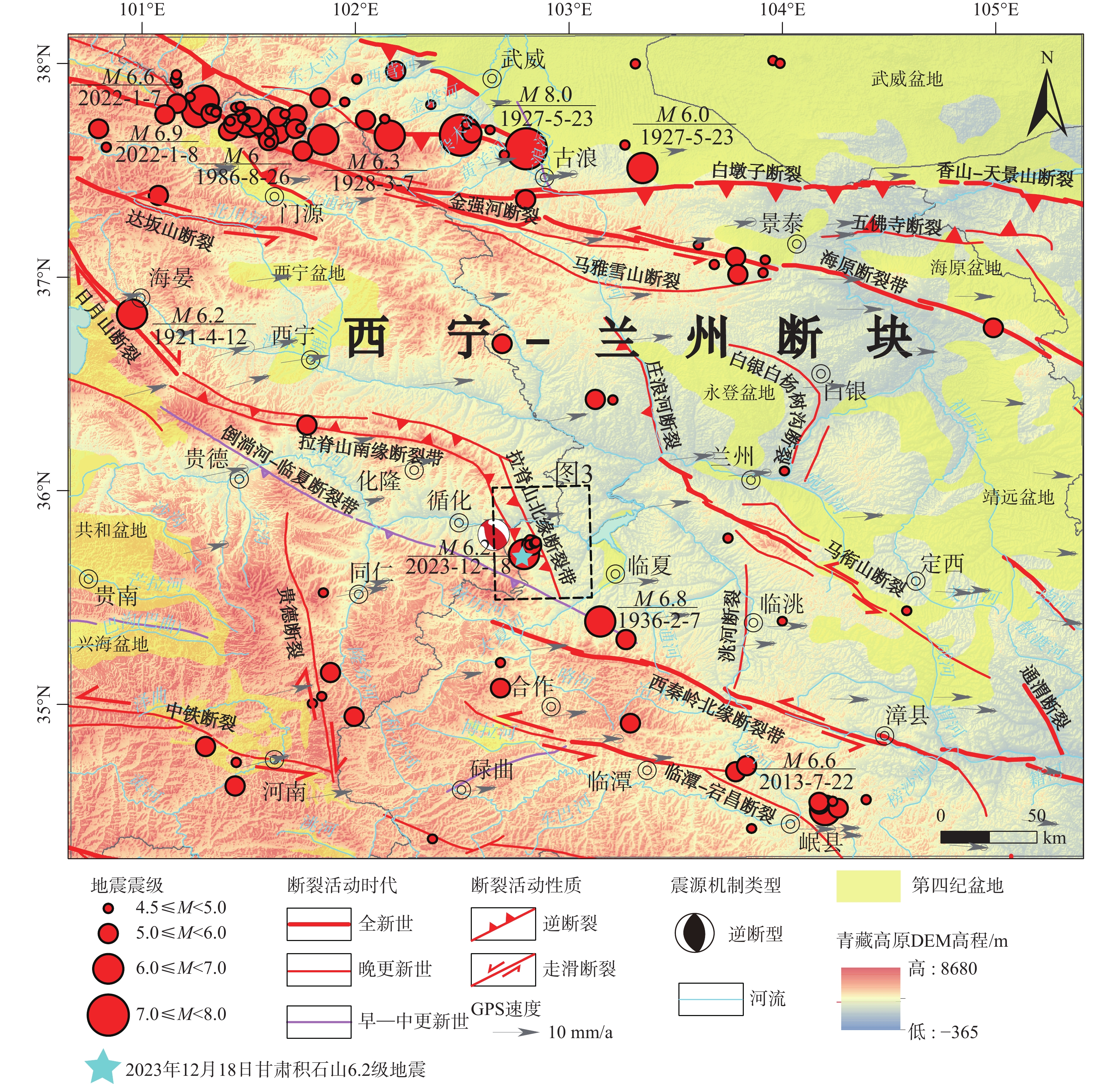
2023年12月18日甘肃省临夏州积石山县发生MS 6.2地震,此次地震诱发了崩塌、滑坡和泥流等一系列地质次生灾害,是近年来中国6级以上地震损失极其严重的一次。综合分析区域孕灾环境及地质次生灾害发育特征发现,拉脊山地区海拔高、地形复杂、活断裂作用显著以及第四纪松散堆积物覆盖广且厚度大等因素,使得该地区在地震作用下极易产生蠕滑−拉裂破坏并诱发滑坡等地质次生灾害。利用层次分析法综合考虑断裂、地层岩性、植被覆盖、坡度及降水5个关键因子对积石山区域地质灾害发育的影响。研究结果显示,地层岩性是区域地质次生灾害的主导因素,其权重可达42%;其次是断层,权重约占26%;而降水的影响权重虽然只占6%,但也不可忽视。积石山及其邻区地质次生灾害危险区主要集中在震中周围的拉脊山前缘一带,呈条状分布,与VIII度地震烈度区域大体一致。地质次生灾害点受软弱地质环境影响为主,集中在拉脊山断裂带下盘,尤其是积石山县、大家河镇和白藏镇等地,灾害分布密集且受地震影响显著,需要重点监测及预防,同时对第四系黄土层防护工程也应予以足够重视。另一方面,在余震分布密集区,未发现显著的地质次生灾害点,推测是因为主震释放了较大应力,诱发了主要地质次生灾害。在多次余震之后,岩体应力状态逐渐趋于平衡,地质构造在震后重组并趋向稳定,从而降低了进一步发生地质次生灾害的风险。
Abstract:Objective The MS6.2 earthquake that struck Jishishan County, Gansu Province, on December 18, 2023, triggered a series of secondary geological disasters, including landslides, collapses, and debris flows. This earthquake is considered one of the most devastating seismic events in China in recent years. The study aims to analyze the characteristics of seismicity-induced disasters in the region and identify the underlying geological factors contributing to these secondary geological hazards. Specifically, the research focuses on how the geological environment influences the development of these disasters, particularly landslides, collapses, and debris flows. This understanding will help to develop better disaster prevention and mitigation strategies for similar seismic regions.
Methods To investigate these issues, the study uses a combination of field investigations, remote sensing image interpretation, and the analytic hierarchy process (AHP). The AHP was employed to evaluate the relative importance of five key factors—faults, lithology, vegetation cover, slope, and precipitation—in the formation of secondary geological hazards. The analysis also includes a detailed spatial distribution study of these factors and how they interact under seismic conditions. This multi-method approach provides a comprehensive understanding of the complex geological environment in Jishishan.
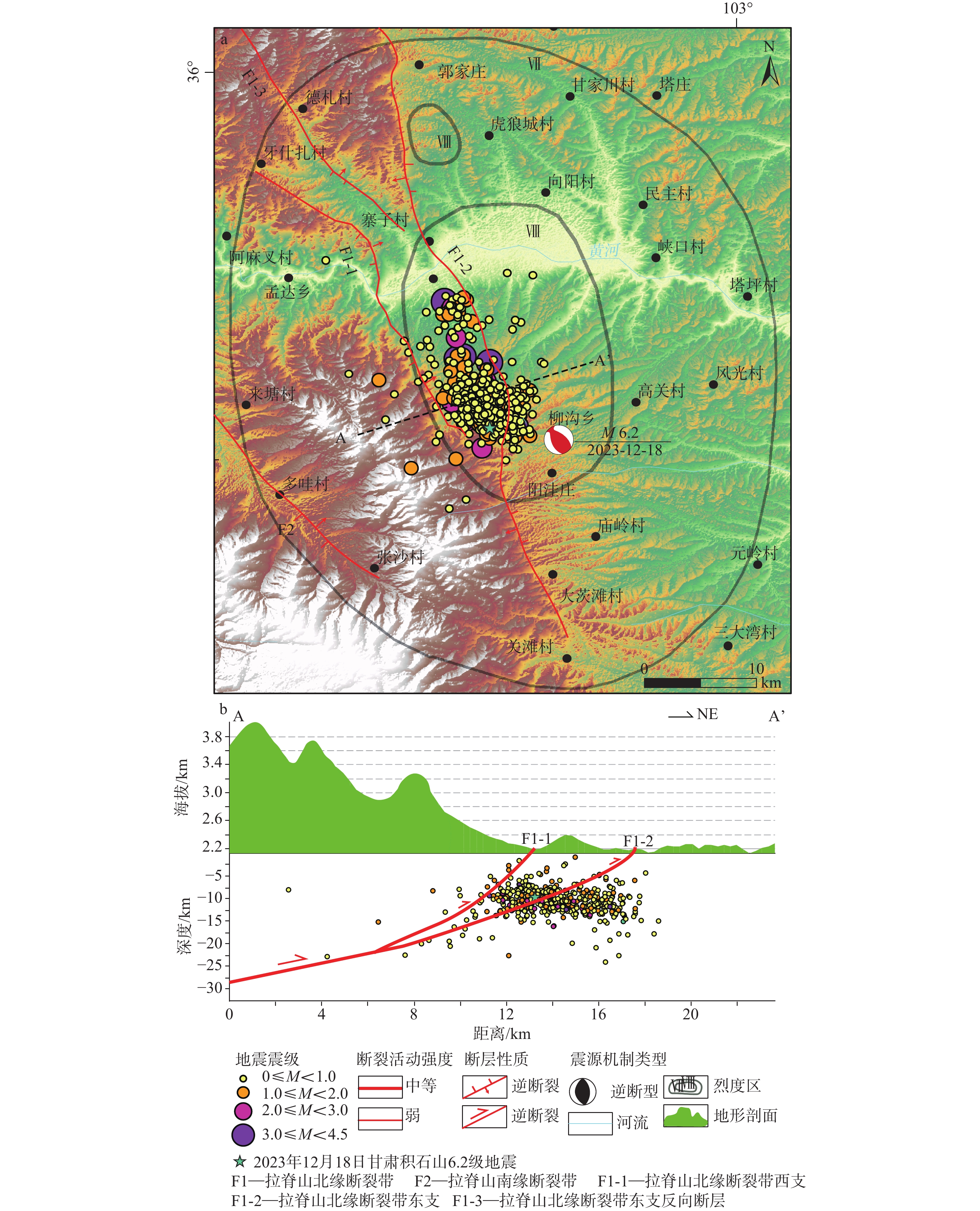
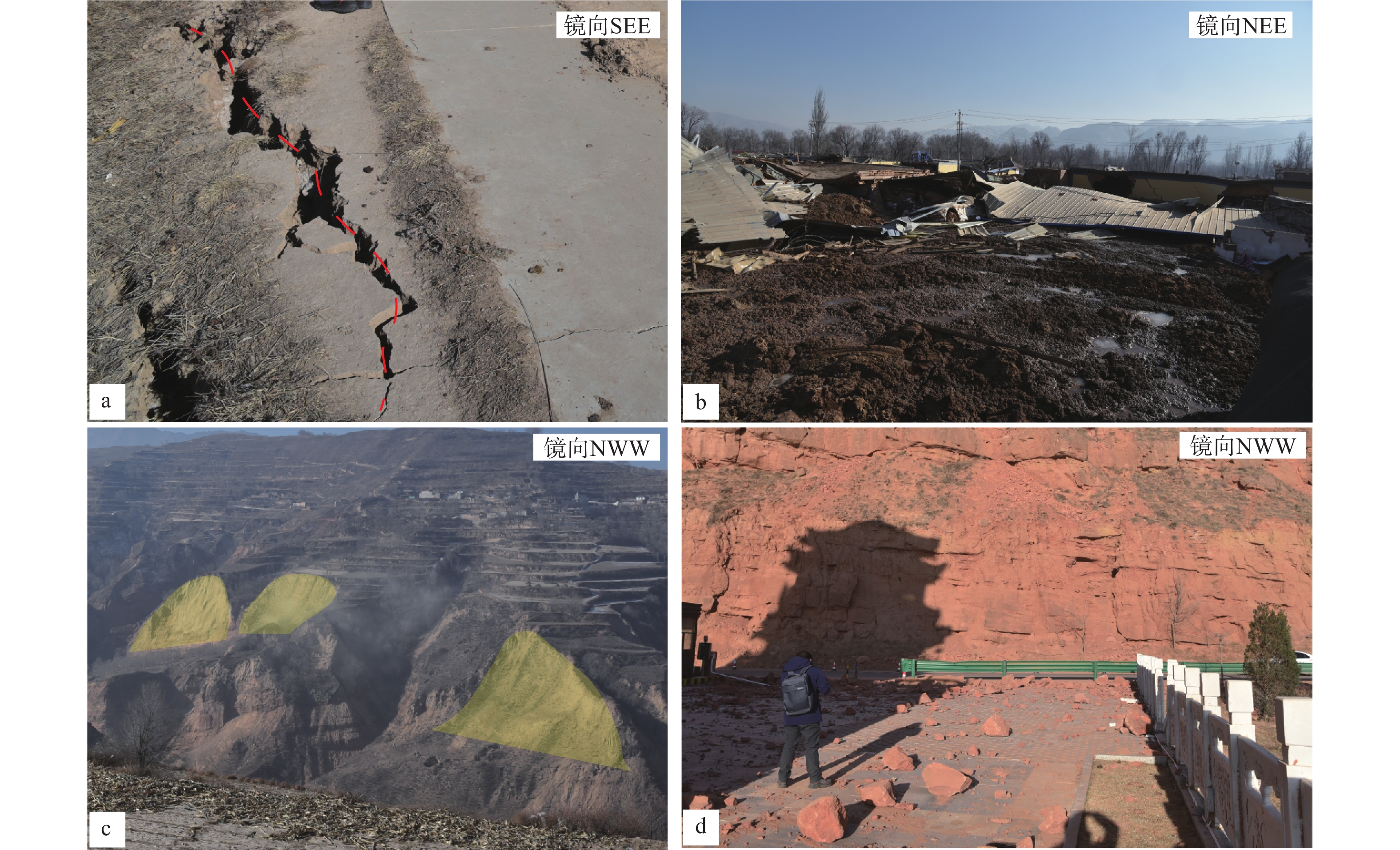
Results Based on the integrated analysis, the secondary geological hazard zones of the study area are primarily concentrated along the front edge of Lajishan, closely aligned with the VIII seismic intensity zone of the Jishishan MS6.2 earthquake. Fewer hazard zones are located at the northern edge of Lijia Village, Guantan Village, and Manisigou Township. The higher-risk areas are centered around Jishishan County, extending eastward toward Lijia Village and Hanji Town. The secondary geological disaster points are concentrated in Jishishan County and the area surrounding it, particularly in valleys where Quaternary strata are abundant, forming a band-like distribution. Landslides are most prevalent in Jishishan County and Dahejia Town, where steep terrain, fragile geological structure, and significant rock weathering make the area vulnerable. The lack of vegetation exacerbates surface instability. Debris flows mainly occur in Baizang Town and around Jishishan, where steep slopes, concentrated rainfall, and abundant loose materials create ideal conditions for disaster. These debris flow sites are located near rivers or lakes, indicating that water flow and increased soil saturation are key factors triggering such events. Landslide sites are generally scattered but concentrated in areas of significant topographic change, following the Quaternary strata in valleys. These sites are denser near the Lajishan fault zone, showing the influence of fault proximity and rainfall on landslide occurrence. Each type of geological disaster exhibits distinct spatial patterns: landslides and debris flows are more likely to occur in areas with steep slopes and proximity to water bodies, while collapses tend to occur in exposed rock areas, influenced by local lithology. Evidently, the distribution of secondary geological hazards in the study area is primarily influenced by weak geological conditions, with seismic activity, vegetation, topography, and precipitation compounding the risk. Hazard zones are concentrated along the front of Lajishan, matching the VIII seismic intensity zone. The disaster sites are primarily located in valleys with dense fourth-level strata, confirming the consistency between the simulated and actual hazard zones.
Conclusion To conclude, lithology was found to be the most significant factor influencing disaster formation, with a weight of 42%, followed by fault zones (26%). While precipitation had the least impact, contributing only 6%, it still played a role in increasing the risk of landslides and debris flows. The high-risk disaster areas correspond closely to the seismic intensity zone VIII, particularly around the earthquake epicenter, where the geological conditions are most conducive to these hazards. The distribution of secondary geological disasters in Jishishan is primarily controlled by the weak geological conditions of the region. Besides, compared to the Wenchuan earthquake, where disasters were concentrated along the hanging wall of reverse faults, the disaster sites in Jishishan were mainly located in the down-thrust areas of fault zones. Additionally, fewer disaster points were observed in aftershock zones, suggesting that the main shock alleviated a significant amount of tectonic stress, leading to regional stabilization. [Significance] This study highlights the relationship between geological factors and seismicity-induced secondary disasters in Jishishan, emphasizing the need for targeted monitoring and protective measures in areas with loose Quaternary deposits and steep slopes. The results provide valuable insight for disaster prevention strategies in Jishishan and other seismic regions with similar geological conditions.
-
Key words:
- Jishishan earthquake /
- disaster-prone environment /
- landslide /
- mudflow /
- spatial analysis
-

-
表 1 积石山区域周边5级以上的历史地震表
Table 1. Table of historical earthquakes of magnitude 5 or greater in the area around Jishishan
序号 时间 地点 震级 震中烈度 参考文献 1 1371年1月29日 渭源北 5 VI 梁明剑,2008 2 1901年 兰州西固区南 5 VI 梁明剑,2008 3 1944年 乐都南 5 VI 袁道阳等,2005 4 1590年7月 乐都东 5 VI 袁道阳等,2005 5 1821—1850年 循化 5 VI 袁道阳等,2005 6 1878年10月 榆中高崖 5 VI 梁明剑,2008 7 1629年 兰州 5½ VII 梁明剑,2008 8 1875年2月6日—1875年3月7日 西宁 5½ VII 袁道阳等,2005 9 1890年2月17日 西宁东 5½ VII 袁道阳等,2005 10 1893年6月1日 西宁南 5½ VII 袁道阳等,2005 11 1968年12月22日 化隆西 5.4 VI 袁道阳等,2005 12 1819年2月24日 化隆 5¾ VII 袁道阳等,2005 13 1847年7月12日 西宁 5¾ VII 袁道阳等,2005 14 1590年7月7日 永靖东南 6 VIII 袁道阳等,2007 15 公元406年 榆中县菀川 6 VII 袁道阳等,2001 16 1440年11月4日 永登 6¼ VIII 梁明剑,2008 17 1936年 康乐 6¾ IX 张波等,2015 18 公元138年 金城−陇西 6¾ IX 袁道阳等,2004b 19 1125年8月30日 兰州 7 IX 袁道阳等,2002 20 1927年 古浪 8 XI 谢虹等,2014  下载: 导出CSV
表 2 因子选取说明及其数据来源
Table 2. Description of selected factors and their data sources
编号 因子 因子内容 数据说明 来源 1 断裂 距断裂距离 指示断裂运动对周边环境影响,靠近断裂危险性越大,远离断裂危险性越小 陆诗铭等,2024 2 地层岩性 地层岩性分区 将地层划分为全新统、古近系及古近系之前与古生代侵入岩等,全新世地层尚未固结成岩,易受地震等影响发育滑坡、泥流、坍塌等灾害 全国地质资料馆https://www.ngac.cn/125cms/c/qggnew/zxfw.htm 3 植被覆盖 植被覆盖分类 根据土地利用分布图绘制植被覆盖图,植被较多的地方土地稳定性大,较难发生滑坡等地质次生灾害 中国科学院地理科学与资源研究所http://www.igsnrr.ac.cn/ 4 坡度 地形特点 坡度越大,则坡体易受地震、降水等影响产生滑坡等地质次生灾害 ALOS DEM (30m分辨率) 5 降水 区域月均降水量 考虑区域降水大小对坡体稳定性影响程度 彭守璋,2020
下载: 导出CSV
表 3 1—9度判断矩阵
Table 3. The AHP judgement matrix from 1 to 9
降水 坡度 植被覆盖 断裂 地层岩性 降水 1.000 0.500 0.333 0.250 0.200 坡度 2.000 1.000 0.500 0.333 0.250 植被覆盖 3.000 2.000 1.000 0.500 0.333 断裂 4.000 3.000 2.000 1.000 0.500 地层岩性 5.000 4.000 3.000 2.000 1.000
下载: 导出CSV
表 4 因子权重表
Table 4. Factor weights
项 特征向量 权重值 最大特征值 CI值 降水 0.312 6.238% 5.068 0.017 坡度 0.493 9.857% 植被覆盖 0.805 16.105% 断裂 1.309 26.179% 地层岩性 2.081 41.621%
下载: 导出CSV
表 5 随机一致性指标
Table 5. Stochastic consistency indicators
n 阶 3 4 5 6 7 8 9 RI值 0.5200 0.8900 1.1200 1.2600 1.3600 1.4100 1.4600 n 阶 10 11 12 13 14 15 16 RI值 1.4900 1.5200 1.5400 1.5600 1.5800 1.5900 1.5943 n 阶 17 18 19 20 21 22 23 RI值 1.6064 1.6133 1.6207 1.6292 1.6358 1.6403 1.6462 n 阶 24 25 26 27 28 29 30 RI值 1.6497 1.6556 1.6587 1.6631 1.667 1.6693 1.6724
下载: 导出CSV
表 6 CR值计算及一致性检验结果表
Table 6. Calculation of the CR value and result of the consistency test
最大特征根 CI值 RI值 CR值 一致性检验结果 5.068 0.017 1.120 0.015 通过
下载: 导出CSV
表 7 评价指标及其分值表
Table 7. Evaluation indicators and their scores
评价指标 指标分类 原始分值 权重分值 总权重//% 地层 全新统 9 3.78 42 古近系 2 0.84 老地层及岩体 1 0.42 断裂 ≤5km 9 2.34 26 5~15km 7 1.82 15~30km 3 0.78 ≥30km 1 0.26 植被覆盖 未利用土地 9 1.44 16 居民、工矿等用地 3 0.48 耕地、草地 2 0.32 林地 1 0.16 水域 0 0 坡度 ≥40° 9 0.9 10 30°~40° 7 0.7 20°~30° 5 0.5 10°~20° 3 0.3 <10° 1 0.1 降水 ≥43mm 9 0.54 6 40~43mm 7 0.42 37~40mm 5 0.3 32~37mm 3 0.18 ≤32mm 1 0.06
下载: 导出CSV
-
[1] BAI Y Z, XU J, XU X W, et al., 2010. Simulations on displacement fields of ground surface in 2008 Wenchuan earthquake: the case of inverse and right-lateral motion of Yingxiu-Beichuan Fault[J]. Seismology and Geology, 32(1): 16-27. (in Chinese with English abstract
[2] BAI Z L, JI L Y, ZHU L Y, et al., 2024. Causes and destructive analysis of the liquefied mudflow in Zhongchuan Town triggered by the 2023 Jishishan, Gansu MS6.2 earthquake[J]. China Earthquake Engineering Journal, 46(4): 768-777. (in Chinese with English abstract doi: 10.20000/j.1000-0844.20240110001
[3] CAI F Q, 2013. New discovery and application of some historical data for the M8.0 earthquake in southern Wudu in 1879[J]. China Earthquake Engineering Journal, 35(2): 311-320. (in Chinese with English abstract
[4]