

The formation mechanism of ground fissures in Qingxu-Taigu area, Shanxi Province
-
摘要:
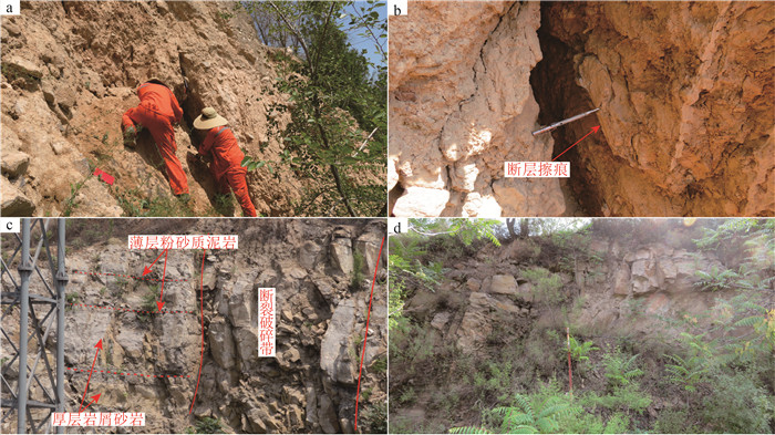
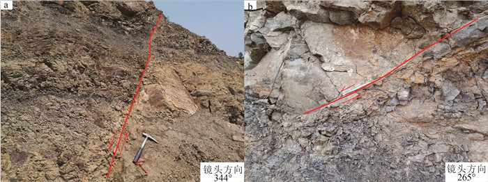
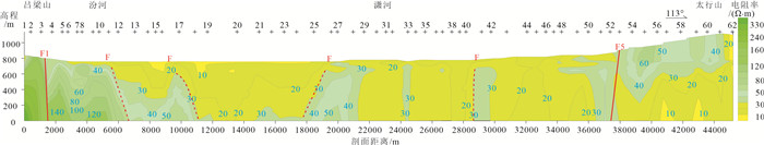
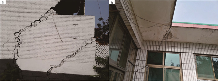
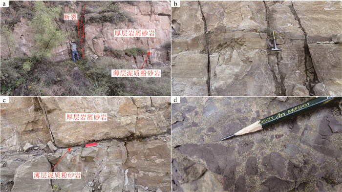
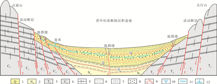
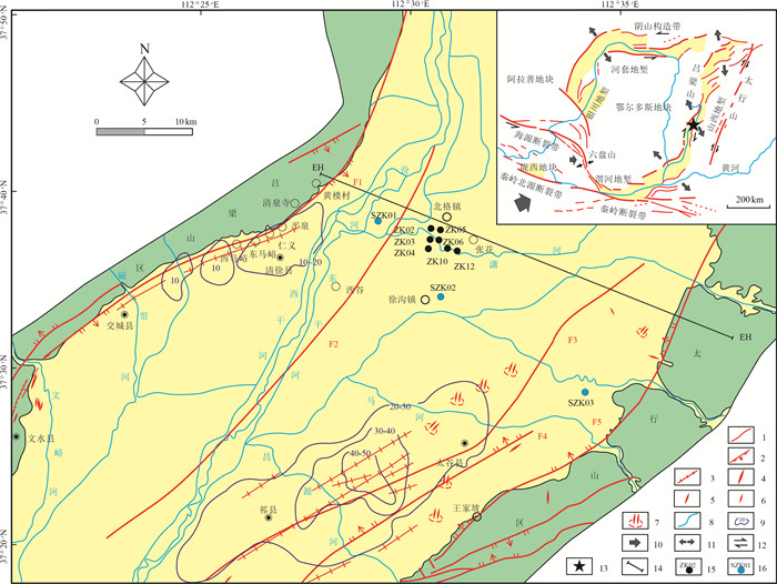
山西清徐—太谷地区是中国地质灾害高发区之一, 地质灾害类型主要有活动断裂、滑坡、地震、地裂缝等。通过对该区开展地面路线地质调查、物探、水文工程钻探等工作, 将地裂缝划分为山前地裂缝和盆地中部地裂缝2类。山前地裂缝主要与断陷盆地盆-山转换带的活动断层有关, 其盆地上基底构造层岩石组合具有软硬相间的"二元结构"特征, 由厚层状砂岩和薄层状粉砂质泥岩组成, 这种"二元结构"在外在因素(如暴雨、地震等)的诱发作用下, 软质层容易产生层间滑动, 导致地裂缝等地质灾害。盆地中部地裂缝除与可能的隐伏断裂有关外, 主要与清徐—太谷地区地下水过度开采有关。水文工程钻探揭露了该断陷盆地中多个含水层, 每个含水层结构中的上下层为不透水的厚大粘土层或粉砂质粘土层, 中间含水层为粉砂或细砂层。当地下水过量开采时, 水位降低, 含水层受上覆地层重力作用影响, 发生沉降形成地裂缝。清徐—太谷地区上更新统粉质泥岩中常可见少量白色膏盐团斑, 推测是造成本区地下水质普遍偏咸的原因。
Abstract:Qingxu-Taigu area, Shanxi Province is one of the high incidence of geological disasters in China, the main types of geological disasters are active fault, landslide, earthquake, ground fissure and so on.This article based on the ground route geology survey, geophysical prospecting and hydrological engineering drilling, preliminarily divided the ground fissures in this area into two categories, which are the ground fissures nearby mountain and the ground fissures in central basin.The ground fissures nearby mountain are mainly associated with the active fault in the transition zone between the mountain and the graben basin, the underlying bedrock of the basin shows the characteristics of "dual structure" mainly consisting of the thick layer of sandstone and thin bedded silty mudstone, which is very easy to produce interlayer slip and lead to geological disasters such as ground fissures induced by the external factors(such as heavy rain and earthquake, etc.).The ground fissures in central basin are mainly related to groundwater overexploitation besides the possible concealed faults under the basin.The results of hydro-engineering drilling show that there are multiple aquifers in the central basin.The aquifers closed by impermeable thick clay layer or silty clay layer are usually composed of silty sands or fine sands.When the groundwater in central basin is overexploited, the water level will decrease, and the aquifer will sink to form ground fissure by the gravity of overlying strata.In addition, a small amount of white salts are often found in the Upper Pleistocene silty mudstone that may be the reason for the general saltiness of underground water in this area
-
Key words:
- Qingxu-Taigu /
- graben basin /
- ground fissure /
- formation mechanism /
- geological survey engineering
-

-
表 1 山西清徐—太谷一带岩土物理参数
Table 1. Rock and soil physical parameters in Qingxu-Taigu area, Shanxi
序号 样号 时代 岩土名称 深度/m 含水率/% 密度/(g·cm-3) 干密度/(g·cm-3) 孔隙度/% 饱和度/% 液限/% 塑限/% 塑性指数 快剪Cq/kPa 1 ZK02-Y3 Q4 粉土 8 21.10 2.07 1.71 36.70 98.50 25.60 16.80 8.80 15.10 2 ZK02-Y5 Q4 粉土 12 19.80 2.07 1.73 36.00 94.90 26.00 17.40 8.60 17.40 3 ZK12-Y12 Q4 粉土 34 20.80 2.07 1.71 36.50 97.40 24.30 15.30 9.00 11.10 4 ZK12-Y14 Q4 粉土 38 19.80 2.09 1.74 35.20 98.30 22.90 15.50 7.40 9.50 5 ZK02-Y14 Q3 粉土 30 17.50 2.09 1.78 34.10 91.20 22.60 14.50 8.10 15.80 6 ZK02-Y31 Q3 粉土 64 20.10 2.09 1.74 35.30 99.10 23.70 17.40 6.30 15.10 7 ZK10-Y14 Q3 粉土 32 16.70 2.09 1.79 33.60 88.90 21.70 13.40 8.20 13.50 平均值 19.40 2.08 1.74 35.34 95.47 23.83 15.76 8.06 13.93 1 ZK10-Y8 Q4 粉质粘土 20 25.70 2.00 1.59 42.00 97.50 36.50 19.90 16.50 25.30 2 ZK12-Y5 Q4 粉质粘土 20 23.80 2.02 1.63 39.80 97.60 28.90 18.00 10.90 20.60 3 ZK12-Y16 Q3 粉质粘土 44 26.30 1.97 1.56 42.90 95.70 37.20 22.60 14.60 30.90 4 ZK10-Y19 Q3 粉质粘土 46 26.20 1.97 1.56 42.40 96.40 32.40 20.90 11.50 23.00 5 ZK02-Y28 Q3 粉质粘土 58 27.30 1.97 1.55 43.10 98.00 32.50 20.30 12.20 30.10 6 ZK12-Y23 Q3 粉质粘土 58 24.40 2.02 1.62 40.10 98.90 28.10 16.70 11.40 21.40 平均值 25.62 1.99 1.59 41.72 97.35 32.60 19.73 12.85 25.22 1 ZK02-Y25 Q3 粘土 52 28.20 1.89 1.47 46.20 90.00 41.20 23.70 17.50 36.40 2 ZK10-Y27 Q3 粘土 64 28.10 1.95 1.52 44.60 95.80 44.70 23.30 21.40 34.80 3 ZK12-25 Q3 粘土 66 31.10 1.89 1.44 47.60 94.30 43.80 23.60 20.20 53.10 平均值 29.13 1.91 1.48 46.13 93.37 43.23 23.53 19.70 41.43 注:测试单位为自然资源部保定矿产资源监督检测中心  下载: 导出CSV
-
[1] Geng D Y, Li Z S. Ground fissure hazards in USA and China[J]. Acta Seismologica Sinica, 2000, 13(4): 466-476. doi: 10.1007/s11589-000-0029-4
[2] Rudolph D L, Cherry J A, Farvolden R N. Groundwater flow and solute transport in fractured lacustrine clay near Mexico city[J]. Water Resources Research, 1991, 27(9): 2187-2201. doi: 10.1029/91WR01306
[3] Ei Baruni S S. Earth fissures caused by groundwater withdrawal in Sarir south agricultural project area, Libya[J]. Applied Hydrogeology, 1994, 2(1): 45-52. doi: 10.1007/s100400050045
[4] Ayalew L, Yamagishi H, Reik G. Ground cracks in Ethiopian rift valley: facts and uncertainties[J]. Engineering Geological, 2004, 75: 309-324. https://www.sciencedirect.com/science/article/pii/S0013795204001498
[5] 彭建兵. 汾渭盆地地裂缝成因研究中的若干关键问题[J]. 工程地质学报, 2007, 15(4): 433-440. doi: 10.3969/j.issn.1004-9665.2007.04.001
[6] 孟令超, 彭建兵, 卢全中, 等. 山西太原盆地地裂缝群发机制与深部构造关系[J]. 中国地质灾害与防治学报, 2019, 30(1): 76-85. https://www.cnki.com.cn/Article/CJFDTOTAL-ZGDH201901009.htm
[7] 邓亚虹, 彭建兵, 慕焕东, 等. 渭河盆地深部构造活动的地裂缝孕育机理[J]. 吉林大学学报(地球科学版), 2013, 43(2): 521-527. https://www.cnki.com.cn/Article/CJFDTOTAL-CCDZ201302020.htm
[8] 陈元明. 山西断陷盆地地裂缝特征分析[J]. 中国地质灾害与防治学报, 2016, 27(3): 72-80. https://www.cnki.com.cn/Article/CJFDTOTAL-ZGDH201603012.htm
[9] 孙晓涵, 彭建兵, 崔向美, 等. 山西太原盆地地裂缝与地下水开采、地面沉降关系分析[J]. 中国地质灾害与防治学报, 2016, 27(2): 91-98. https://www.cnki.com.cn/Article/CJFDTOTAL-ZGDH201602014.htm
[10] 苏宗正, 郝何龙, 侯廷爱, 等. 太原盆地的地裂及其灾害[J]. 山西地震, 2000, (3): 1-5. https://www.cnki.com.cn/Article/CJFDTOTAL-SXDZ200003000.htm
[11] 汪丽, 李新生, 李同录. 隐伏地裂缝扩展的大型原位浸水试验研究[J]. 地质力学学报, 2019, 25(3): 412-420. https://www.cnki.com.cn/Article/CJFDTOTAL-DZLX201903008.htm
[12] Peng J B, Qiao J W, Sun. Distribution and generative mechanisms of ground fissures in China[J]. Journal of Asian Earth Sciences, 2020, 191: 1-14.
[13] Howard K W F, Zhou W F. Overview of ground fissure research in China[J]. Environmental Earth Sciences, 2019, 78(3): 97. doi: 10.1007/s12665-019-8114-6
[14] 谢新生, 江娃利, 孙昌斌, 等. 山西交城断裂带多个大探槽全新世古地震活动对比研究[J]. 地震地质, 2008, 30(2): 412-430. https://www.cnki.com.cn/Article/CJFDTOTAL-DZDZ200802008.htm
[15] 谢新生, 江娃利, 王焕贞, 等. 山西太谷断裂带全新世活动及其与1303年洪洞8级地震的关系[J]. 地震学报, 2004, 26(3): 281-293. https://www.cnki.com.cn/Article/CJFDTOTAL-DZXB200403006.htm
[16] 张岳桥, 廖昌珍, 施炜, 等. 鄂尔多斯盆地周边地带新构造演化及其区域动力学背景[J]. 高校地质学报, 2006, 12(3): 285-297. https://www.cnki.com.cn/Article/CJFDTOTAL-GXDX200603002.htm
[17] 门玉明, 彭建兵, 李寻昌. 山西清徐县地裂缝灾害现状及类型分析[J]. 工程地质学报, 2007, 15(4): 453-457. https://www.cnki.com.cn/Article/CJFDTOTAL-GCDZ200704005.htm
[18] 马秀芳, 赵晋泉, 薛晓东, 等. 山西清徐地裂缝调查与灾害损失评估研究[J]. 地震工程学报, 2016, 38(2)增刊: 308-313. https://www.cnki.com.cn/Article/CJFDTOTAL-ZBDZ2016S2023.htm
[19] 叶黎明, 齐天俊, 彭海燕. 鄂尔多斯盆地东部山西组海相沉积环境分析[J]. 沉积学报, 2008, 26(2): 202-210. https://www.cnki.com.cn/Article/CJFDTOTAL-CJXB200802006.htm
[20] 王涛, 徐鸣洁, 王良书, 等. 鄂尔多斯及邻区航磁异常特征及其大地构造意义[J]. 地球物理学报, 2007, 50(1): 163-170. https://www.cnki.com.cn/Article/CJFDTOTAL-DQWX200701022.htm
[21] 马寅生, 赵逊, 赵希涛, 等. 太行山南缘新生代的隆升与断陷过程[J]. 地球学报, 2007, 28(3): 219-233. https://www.cnki.com.cn/Article/CJFDTOTAL-DQXB200703000.htm
-

图(8)
表(1)
计量
- 文章访问数: 1639
- PDF下载数: 60
- 施引文献: 0