

Research of basin water balance and water conservation variation based on multi-source data: a case study of Xiaoluan River Basin in Bashang plateau
-
摘要:
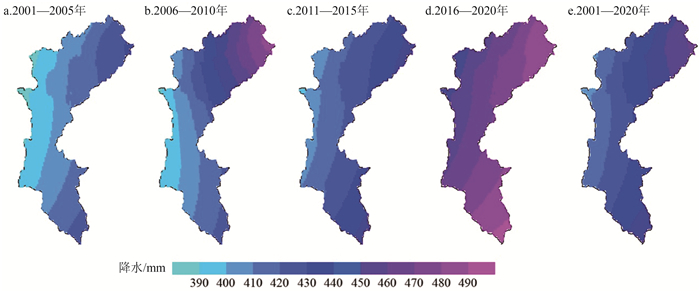
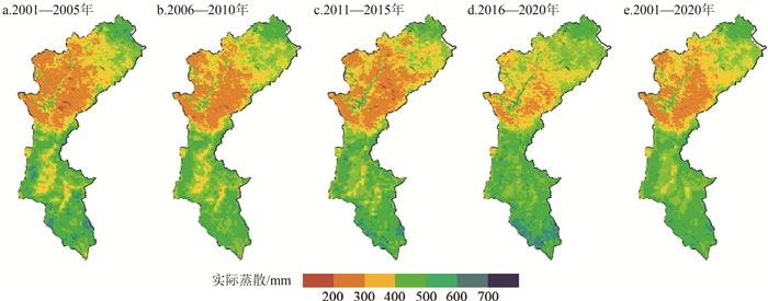
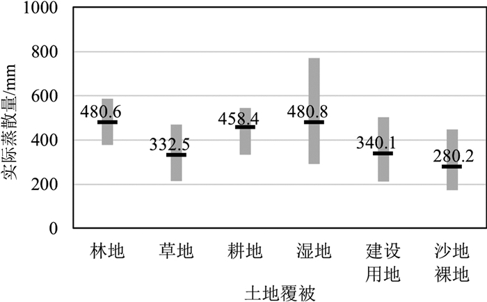
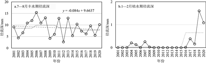
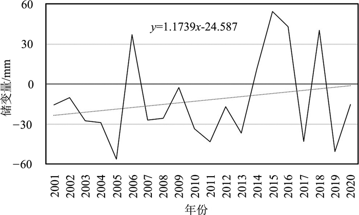
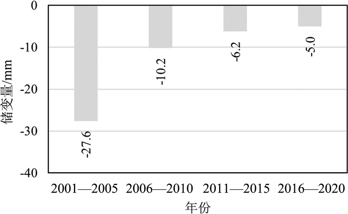
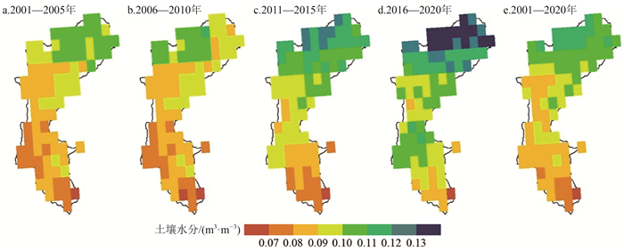
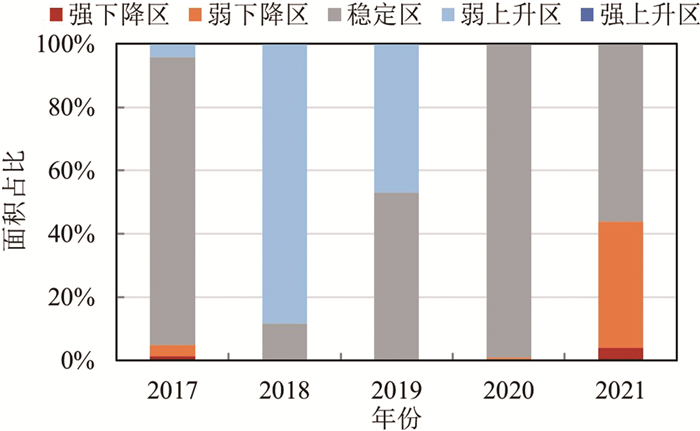
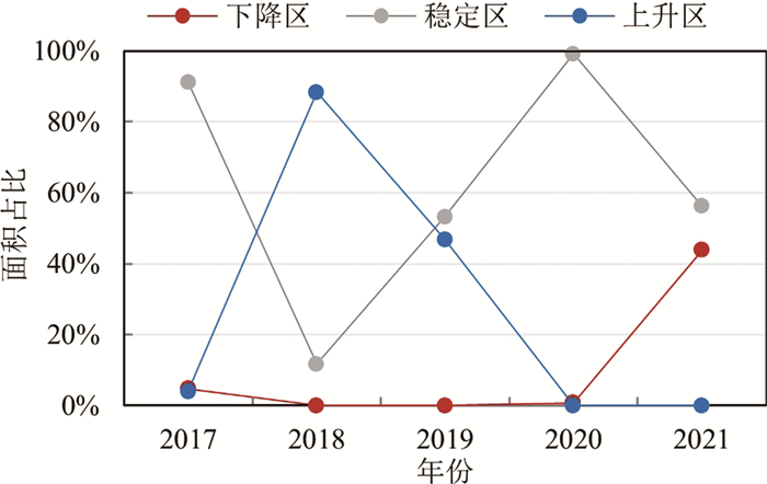
水在海-气-冰-岩各圈层中运移完成水循环过程,但工业革命以来由于气候变化和人类活动影响,水资源收支不等造成水源涵养或亏缺存在空间差异。通过长期监测小滦河流域2001—2020年的气象、地表水文数据,定期实地调查地下水和土地覆被样本,搜集遥感反演的土壤水分资料,借助ETWatch模型估算实际蒸散,遥感反演土地覆被,运用水平衡公式核算小滦河流域降水、实际蒸散、径流、储变量之间的动态平衡关系,从土壤水和地下水2个角度分析水源涵养时空分布特征,以了解小流域水循环过程变化规律,解决水源涵养重点保护生态空间定位和水源涵养区的水资源管理问题。结果表明:2001—2020年降水以平均3.76 mm/a的速率增加,2001—2015年增长缓慢,2016—2020年快速增加,空间分布上呈现“东多西少”,最高值出现在流域东北部的塞罕坝机械林场。实际蒸散量以平均2.71 mm/a的速率增加,慢于降水的增加速率,2014年以后,高降水年的实际蒸散低于降水,水分被储存下来或用于其后的低降水年蒸散消耗,空间分布从上游到下游呈现“高—低—高”的空间格局,实际蒸散量表现为,湿地>林地>耕地>建设用地>草地>沙地裸地。径流以平均0.13 mm/a的速率减少,丰水期径流减小速率快于年径流,但枯水期的径流增加,“削峰补枯”效应明显。储变量虽为负值但以1.17 mm/a的速率增加,越来越多的水资源被涵养在土壤和地下;土壤水分以0.0018(m3/m3)/a的速率增加,上游多下游少,最高值出现在流域北部偏西的林草交错带,2010年以后,土壤水高值区从中游向下游扩展。地下水潜水位上升区面积远大于下降区面积,总体变化为稳中上升趋势,8—9月达到全年水位最高值。本文从综合调查监测的角度探索了小流域水平衡研究方法,为水资源综合管理提供支撑。
Abstract:Water moves among sea, atmosphere, ice and lithosphere, which is described as water cycle or hydrology cycle.In the context of global change and anthropogenic influence since the industrial revolution, unbalanced relationship between input water and output water leads to water resource conserved or short, consequently spatial distributing variously.In this study, long time meteorology and surface water data were obtained from 2001 to 2020, groundwater and land cover were surveyed, soil water data from remote sensing retrieval were collected, and actual evapotranspiration data were generated by ETWatch model.All of these data were applied to water balance accounts in order to illustrate dynamic balanced relationship between precipitation, actual evapotranspiration, runoff and variable storage, as well as analyze water conservation distribution from viewpoints of soil water and groundwater, in order to understand hydrological process conversion, locate key protective ecological space and solve water resource management problems in water conservation zone.Results showed that in Xiaoluan River Basin: (1)Precipitation increased with a trend of 3.76 mm/a, slowly from 2001 to 2015 while fast from 2016 to 2020 and exhibited spatial variability, decreasing gradually from east to west, with the highest value in Saihanba Forest Farm located in the northeast of the basin.(2)Actual evapotranspiration increased with a trend of 2.71 mm/a, lower than that of precipitation.It was lower than precipitation in years with more precipitation, when water was reserved or supplied to evaporate and transpire in later years with less precipitation.The spatial distribution was characterized as "high-low-high" from upper to lower reaches.Actual evapotranspiration of wetland>forest>cultivated land>construction land>grass>sandy and naked land.(3)Runoff decreased with a trend of 0.13 mm/a.The decreasing rate of wet season was greater than that of the whole year, while it showed an increasing trend in dry season, certificating a significant "reducing flood peak and compensating for the drought" effect.(4)Variable storage increased with a trend of 1.17 mm/a in spite of negative value and more and more water resource were stored in the form of soil water and groundwater.Soil water increased with a trend of 0.0018(m3/m3)/a and exhibited spatial variability, decreasing from upper to lower reaches, with the highest value in the ecotone of forest and grass located in the west-north of the basin.Since 2010, high soil water zone stretched from middle to lower reaches.Groundwater maintained stable with a slight rise.The area of groundwater level rising zone was larger than that of falling zone, with high level from August to September.Researching method of water balance in small basin was explored at the view of integrated survey and monitoring, providing support for water resource integrated management.
-
Key words:
- small river basin /
- water balance /
- water conservation /
- actual evapotranspiration /
- soil water /
- groundwater
-

-
[1] IPCC. Climate change 2013: the physical science basis[M]. Cambridge: Cambridge University Press, 2014.
[2] 巢清尘, 严中伟, 孙颖, 等. 中国气候变化的科学新认知[J]. 中国人口·资源与环境, 2020, 30(3): 1-9. https://www.cnki.com.cn/Article/CJFDTOTAL-ZGRZ202003001.htm
[3] 姜大膀, 王娜. IPCC AR6报告解读: 水循环变化[J]. 气候变化研究进展, 2021, 17(6): 699-704. https://www.cnki.com.cn/Article/CJFDTOTAL-QHBH202106009.htm
[4] Gudmundsson L, Boulange J, Do H X, et al. Globally observed trends in mean and extreme river flow attributed to climate change[J]. Science, 2021, 371(6534): 1159-1162. doi: 10.1126/science.aba3996
[5] 于宏源, 李坤海. 地缘性介入与制度性嵌构: 美国亚太区域水安全外交战略[J]. 国际安全研究, 2020, 5: 60-80. https://www.cnki.com.cn/Article/CJFDTOTAL-GGXB202005004.htm
[6] 吴凤平, 季英雯, 李芳, 等. 跨境水资源分配典型模式特征评述及中国主张思考[J]. 自然资源学报, 2021, 36(7): 1861-1872. https://www.cnki.com.cn/Article/CJFDTOTAL-ZRZX202107016.htm
[7] European Environment Agency. European waters-Assessment of status and pressures 2018[M]. EEA Report, 2018: 7.
[8] U.S. Geological Survey. Groundwater and Streamflow Information Program[EB/OL](2021-05)https://www.usgs.gov/water-resources/groundwater-and-streamflow-information.
[9] 张诚, 曹国亮, 陈娟, 等. 丹麦水资源综合管理经验及启示[J]. 水利水电快报, 2019, 40(5): 12-16. doi: 10.15974/j.cnki.slsdkb.2019.05.002
[10] 李文鹏, 袁富强, 王龙凤. 中国地质调查局水文地质与水资源调查计划进展简介[J]. 中国地质, 2021, 48(4): 974. https://www.cnki.com.cn/Article/CJFDTOTAL-DIZI202104001.htm
[11] Ye A Z, Deng X X, Ma F, et al. Integratiing weather and climate predictions for seamless hydrologic ensemble forecasting: A case study in the Yalong River basin[J]. Journal of Hydrology, 2017, 547: 196-207. doi: 10.1016/j.jhydrol.2017.01.053
[12] Beamer J P, Hill D F, Mcgrath D, et al. Hydrologic impacts of changes in climate and glacier extent in the Gulf of Alaska watershed[J]. Water Resource Research, 2017, 53(9): 7502-7520. doi: 10.1002/2016WR020033
[13] Jiang X, Ma R, Ma T, et al. Modeling the effects of water diversion projects on surface water and groundwater interactions in the central Yangtze River basin[J]. Science of the Total Environment, 2022, 830: 154606. doi: 10.1016/j.scitotenv.2022.154606
[14] Sutton R T. Climate Science needs to take risk assessment much more seriously[J]. Bulletin of the American Meteorological Society, 2019, 9: 1637-1642.
[15] Ukkola A M, Kauwe M, Roderick M L, et al. Robust future changes in meteorological drought in cmip6 projections despite uncertainty in precipitation[J]. Geophysical Research Letters, 2020, 47(11): e2020GL087820.
[16] Yang Y, Zhang S, Roderick M L, et al. Comparing Palmer Drought Severity Index drought assessments using the traditional offline approach with direct climate model outputs[J]. Hydrology and Earth System Sciences, 2020, 24(6): 2921-2930. doi: 10.5194/hess-24-2921-2020
[17] Milly P C, Dunne K A. A hydrologic drying bias in water-resource impact analyses of anthropogenic climate change[J]. Journal of the American Water Resources Association, 2017, 53(4): 822-838. doi: 10.1111/1752-1688.12538
[18] Yang D W, Yang Y T, Xia J. Hydrological cycle and water resources in a changing world: A review[J]. Geography and Sustainability, 2021, 2: 115-122. doi: 10.1016/j.geosus.2021.05.003
[19] Chawla I, Karthikeyan L, Mishra A K. A review of remote sensing applications for water security: Quantity, quality, and extremes[J]. Journal of Hydrology, 2020, 585: 124826. doi: 10.1016/j.jhydrol.2020.124826
[20] 胡实, 韩建, 占车生, 等. 基于地理加权回归模型的典型山地卫星反演降水产品降尺度研究[J]. 山地学报, 2019, 37(3): 451-461. https://www.cnki.com.cn/Article/CJFDTOTAL-SDYA201903015.htm
[21] Wu F M, Wu B F, Zhu W W, et al. ETWatch cloud: APIs for regional actual evapotranspiration data generation[J]. Environmental Modelling and Software, 2021, 145: 105174. doi: 10.1016/j.envsoft.2021.105174
[22] 闫柏琨, 李文鹏, 甘甫平, 等. 基于地表水循环遥感观测的黑河流域水平衡分析[J]. 水文地质工程地质, 2022, 49(3): 44-56. https://www.cnki.com.cn/Article/CJFDTOTAL-SWDG202203005.htm
[23] 贺缠生, James L. 流域科学: 连接水文学与流域可持续管理的枢纽[J]. 中国科学: 地球科学, 2021, 51(5): 666-679. https://www.cnki.com.cn/Article/CJFDTOTAL-JDXK202105002.htm
[24] 张圆, 贾贞贞, 刘绍民, 等. 遥感估算地表蒸散发真实性检验研究进展[J]. 遥感学报, 2020, 24(8): 975-999. https://www.cnki.com.cn/Article/CJFDTOTAL-YGXB202008004.htm
[25] 孙厚云, 卫晓锋, 孙晓明, 等. 御道口汉诺坝玄武岩偏硅酸矿泉水形成机制及其地质建造制约[J]. 地球科学, 2020, 45(11): 4236-4253. https://www.cnki.com.cn/Article/CJFDTOTAL-DQKX202011027.htm
[26] 中国气象局. 地面气象观测资料质量控制QX/T 118—2010[S]. 北京: 气象出版社, 2010.
[27] 俞卫平. 地面气象观测规范[S]. 北京: 气象出版社, 2003.
[28] 毛克彪. 中国土壤水分数据集(2002—2018)[DB/OL]. 国家青藏高原科学数据中心, http://data.tpdc.ac.cn/zh-hans/data/3c4feb37-7f5b-4aa6-b906-3b23dd4c520e/2021.
[29] Meng X, Mao K, Meng F, et al. A fine-resolution soil moisture dataset for China in 2002-2018[J]. Earth System Science Data, 2021, 13(7): 3239-3261.
[30] Wu B F, Zhu W W, Yan N N, et al. An improved method for deriving daily evapotranspiration estimates from satellite estimates on cloud-free days[J]. IEEE Journal of Selected Topics in Applied Earth Observations & Remote Sensing, 2016, 9(4): 1323-1330.
[31] Wu B F, Zhu W W, Yan N N, et al. Regional actual evapotranspiration estimation with land and meteorological variables derived from multi-source satellite data[J]. Remote sensing, 2020, (12): 332.
[32] Wu B F, Yan N N, Xiong J, et al. Validation of ETWatch using field measurements at diverse landscapes: A case study in Hai Basin of China[J]. Journal of Hydrology, 2012, (436/437): 67-80.
[33] Wu F M, Wu B F, Zhu W W, et al. ETWatch cloud: APIs for regional actual evapotranspiration data generation[J]. Environmental Modelling and Software, 2021, 145: 105174.
[34] Wu B F, Jiang L P, Yan N N, et al. Basin-wide evapotranspiration management: Concept and practical application in Hai Basin, China[J]. Agricultural Water Management, 2014, 145: 145-153.
[35] 芮孝芳. 水文学原理[M]. 北京: 高等教育出版社, 2018.
[36] 龚诗涵, 肖洋, 郑华, 等. 中国生态系统水源涵养空间特征及其影响因素[J]. 生态学报, 2017, 37(7): 2455-2462. https://www.cnki.com.cn/Article/CJFDTOTAL-STXB201707033.htm
[37] 郝立生, 闵锦忠, 顾光芹. 华北夏季降水减少与北半球大气环流异常的关系[J]. 大气科学学报, 2010, 33(4): 420-426. https://www.cnki.com.cn/Article/CJFDTOTAL-NJQX201004004.htm
[38] 气候公报编写规范QX/T 573-2020[S]. 北京: 中国气象局, 2020.
[39] 程宇琪, 王雨晴, 孙静萍, 等. 多伦县草原植被覆盖与蒸散量时空变化及其关系[J]. 国土资源遥感, 2020, 32(1): 200-208. https://www.cnki.com.cn/Article/CJFDTOTAL-GTYG202001028.htm
[40] 郭晓彤, 孟丹, 蒋博武, 等. 基于MODIS蒸散量数据的淮河流域蒸散发时空变化及影响因素分析[J]. 水文地质工程地质, 2021, 48(3): 45-52. https://www.cnki.com.cn/Article/CJFDTOTAL-SWDG202103007.htm
[41] 中国气象局气候变化中心, 中国气候变化蓝皮书(2021)[M]. 北京: 科学出版社, 2021.
[42] 李禧亮, 武姗姗, 陈子健, 等. 崇礼赛区地形影响降水特征分析[J]. 水电能源科学, 2021, 39(4): 1-4. https://www.cnki.com.cn/Article/CJFDTOTAL-SDNY202104001.htm
[43] 孙敏茹, 郭玲玲, 闵学武, 等. 塞罕坝机械林场气候因子变化与当地林业发展的关系[J]. 河北林业科技, 2013, (5): 69-71. https://www.cnki.com.cn/Article/CJFDTOTAL-HBLK201305024.htm
[44] 罗叙, 李建平, 张翼, 等. 荒漠草原土壤水分时空变化对降水变化的响应[J]. 水土保持研究, 2021, 28(4): 143-152.
[45] 赵建生, 王永明, 杨新兵. 冀北山地森林土壤水文效应研究[J]. 水土保持研究, 2013, 20(3): 201-205. https://www.cnki.com.cn/Article/CJFDTOTAL-STBY201303041.htm
[46] 白晓, 张兰慧, 王一博, 等. 祁连山区不同土地覆被类型下土壤水分变异特征[J]. 水土保持研究, 2017, 24(2): 17-25. https://www.cnki.com.cn/Article/CJFDTOTAL-STBY201702004.htm
[47] 刘苏峡, 邢博, 袁国富, 等. 中国根层与表层土壤水分关系分析[J]. 植物生态学报, 2013, 37(1): 1-17. https://www.cnki.com.cn/Article/CJFDTOTAL-ZWSB201301002.htm
-
 下载:
下载:


图(15)
计量
- 文章访问数: 2329
- PDF下载数: 84
- 施引文献: 0