

-
摘要:
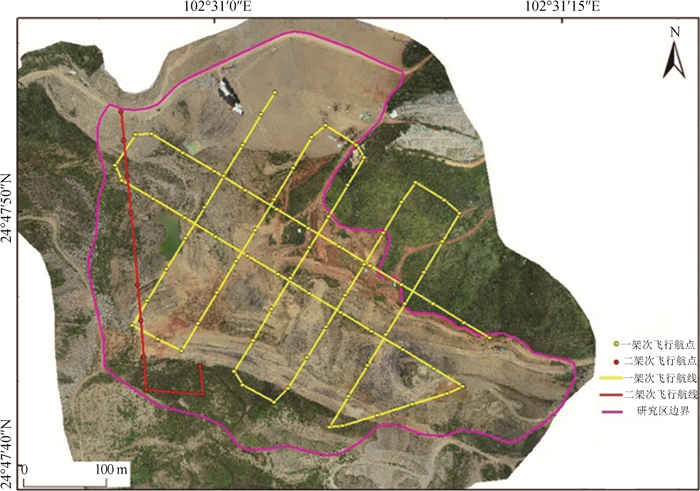
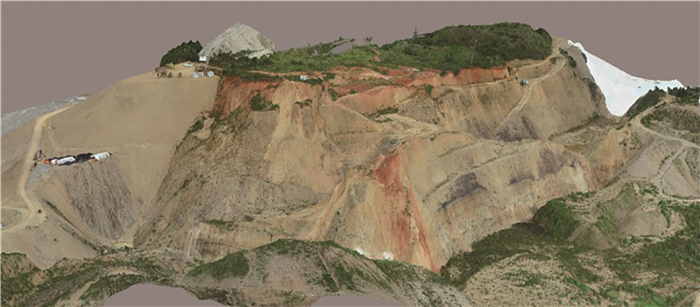
传统的无人机测量技术用于矿山测量须进行必要控制点的测设,也使无人机测设在复杂地形、难以进入等地区存在一定的应用瓶颈。免像控航测技术可以不提前布设控制点,成为矿山地貌形态调查的一种重要趋势。以昆明市某露天采矿区为研究区,利用DJI PHANTOM 4 RTK无人机进行航摄,分析免像控航测技术的关键技术和作业流程,完成了DOM(数字正摄模型)、DEM(数字高程模型)、DSM(数字栅格地图)和DLG(数字线划地图)制作、三维模型构建及模型内、外精度分析,对研究区地貌形态分布情况与特征参数进行分析统计。实验结果论证了免像控航测技术在矿山地貌景观调查中的可行性,为合理化开发矿产资源、最大化恢复生态环境提供技术支撑。
Abstract:The traditional unmanned aerial vehicle survey technology used in mine survey must carry out the necessary control points measurement, which also makes the unmanned aerial vehicle survey in complex terrain, difficult to access and other areas has a certain application bottleneck.The image-free aerial survey technology is an important trend of mine landform survey, which needs not layout the control points in advance.Taking an open-pit mining area in Kunming City as the research area, this paper carries out aerial photography with DJI phantom 4 RTK UAV, analyzes the key technology and operation process of image free aerial survey technology, and then DOM, DEM, DSM and DLG production, three-dimensional model construction and model internal and external precision analysis are completed.The distribution of geomorphic form and characteristic parameters in the study area are analyzed and counted.The experimental results demonstrate the feasibility of image-free aerial survey technology in the investigation of mine landscape, and provide technical support for the rational development of mineral resources and the maximum restoration of ecological environment.
-
Key words:
- image-free control /
- unmanned aerial vehicle /
- mine /
- topography
-

-
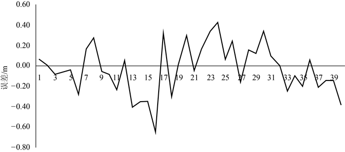
表 1 空中三角质量报告
Table 1. Quality report of aerial triangulation
名称 点数 重投影中误差/m 重投影均方根误差/m 距离均方根误差/m 数值 31972 0.39 0.53 0.028  下载: 导出CSV
表 2 坡面几何信息统计
Table 2. Slope geometry information statistics
边坡编号 坡底高程/m 坡顶高程/m 边坡高差/m 边坡长度/m 1 2049.32 2075.30 25.98 58.58 2 2049.32 2075.30 25.98 58.58 3 2049.32 2075.30 25.98 58.58 4 2010.55 2045.87 35.32 46.56 5 2007.01 2083.66 76.65 103.31 6 2024.67 2086.59 61.92 73.01 7 2014.18 2034.35 20.17 25.65 均值 2029.20 2068.05 38.86 60.61
下载: 导出CSV
表 3 坡面方位信息统计
Table 3. Slope orientation information statistics
边坡编号 边坡坡度/° 坡地类型 边坡坡向 坡向取值/° 坡向俗称 1 24 中陡坡 北 22 阴 2 28 中陡坡 西北 314 半阴 3 24 中陡坡 西南 247 半阳 4 40 陡坡 西南 203 半阳 5 65 陡崖 北 337 半阴 6 69 陡崖 南 180 阳 7 36 陡坡 北 20 阴
下载: 导出CSV
表 4 堆体相关参数统计
Table 4. Statistics of reactor related parameters
堆体编号 底面积/m2 表面积/m2 体积/m3 1 18187.25 21895.12 268834.62 2 8438.59 11236.44 90576.47 合计 26625.84 33131.56 359411.09
下载: 导出CSV
表 5 矿坑相关参数统计
Table 5. Statistics of related parameters of mine pit
矿坑编号 周长/m 面积/m2 填方量/m3 Ⅰ 97.50 65.46 9201.16 Ⅱ 198.25 1964.46 21015.38 Ⅲ 371.17 3864.23 61799.72 合计 666.92 5894.15 92016.26
下载: 导出CSV
-
[1] Banerjee B P, Raval S, Maslin T J, et al. Development of a UAV-mounted system for remotely collecting mine water samples[J]. International Journal of Mining, Reclamation & Environment, 2020, 34(6): 385-396.
[2] Ćwiąkała P, Grusński W, Stoch T, et al. UAV Applications for Determination of Land Deformations Caused by Underground Mining[J]. Remote Sensing, 2020, 12(11): 1733. doi: 10.3390/rs12111733
[3] Winkelmaier G, Battulwar R, Khoshdeli M, et al. Topographically guided UAV for identifying tension cracks using image-based analytics in open-Pit Mines[J]. IEEE Transactions on Industrial Electronics, 2021, 68(6): 5415-5424. doi: 10.1109/TIE.2020.2992011
[4] Kun M. Assessment and monitoring of rehabilitation studies on coal mine dump site with uav's[J]. Applied Ecology & Environmental Research, 2019, 17(4): 7381-7393.
[5] Li Y, Mo P. A unified landslide classification system for loess slopes: A critical review[J]. Geomorphology, 2019, 340: 67-83. doi: 10.1016/j.geomorph.2019.04.020
[6] Benaissi L, Tarek A, Tobi A, et al. Geological mapping and mining prospecting in the Aouli inlier(Eastern Meseta, Morocco) based on remote sensing and geographic information systems(GIS)[J]. China Geology, 2022, 5(4): 614-629.
[7] Rajendra Y D, Mehrotra S C, Kale K V, et al. Evaluation of Partially Overlapping 3D Point Cloud's Registration by using ICP variant and CloudCompare[J]. Isprs technical commission viii symposium International Archives of the Photogrammetry Remote Sensing and Spatial Information Sciences, 2014, 40-48: 891-897.
[8] Tong X, Liu X, Chen P. Integration of UAV-Based Photogrammetry and terrestrial laser scanning for the three-dimensional mapping and monitoring of open-Pit Mine Areas[J]. Remote sensing, 2015, 7(6): 6635-6662. doi: 10.3390/rs70606635
[9] 邓文彬. 测绘数字制图与成图[M]. 重庆: 重庆大学出版社, 2017.
[10] 建设综合勘察研究设计院. 工程地质测绘标准: CECS 238-2008[S]. 北京: 中国计划出版社, 2008.
[11] 何芳, 刘瑞平, 徐友宁, 等. 基于遥感的木里煤矿区矿山地质环境监测及评价[J]. 地质通报, 2018, 37(12) : 2251-2259. http://dzhtb.cgs.cn/gbc/ch/reader/view_abstract.aspx?file_no=20181216&flag=1
[12] 侯恩科, 张杰, 谢晓深, 等. 无人机遥感与卫星遥感在采煤地表裂缝识别中的对比[J]. 地质通报, 2019, 38(2/3) : 443-448. http://dzhtb.cgs.cn/gbc/ch/reader/view_abstract.aspx?file_no=2019020325&flag=1
[13] 黄军, 李涛, 朱俊利. 免像控无人机航测新技术在露天矿开采监测中的应用[J]. 测绘通报, 2018, (11) : 154-157. doi: 10.13474/j.cnki.11-2246.2018.0371
[14] 贾曙光, 金爱兵, 赵怡晴. 无人机摄影测量在高陡边坡地质调查中的应用[J]. 岩土力学, 2018, 39(3) : 1130-1136. https://www.cnki.com.cn/Article/CJFDTOTAL-YTLX201803044.htm
[15] 李伟哲. 基于ContextCapture实景建模及应用[J]. 西北水电, 2018, (3) : 27-31. https://www.cnki.com.cn/Article/CJFDTOTAL-SBXX201803008.htm
[16] 梁鑫, 范文, 苏艳军, 等. 秦岭钒矿集中开采区隐蔽性地质灾害早期识别研究[J]. 灾害学, 2019, 34(1) : 208-214. https://www.cnki.com.cn/Article/CJFDTOTAL-ZHXU201901038.htm
[17] 马海政, 强德霞. 免像控无人机航摄系统在大比例尺地形图测量中的应用[J]. 测绘通报, 2020, (7) : 159-161. https://www.cnki.com.cn/Article/CJFDTOTAL-CHTB202007034.htm
[18] 王凤艳, 赵明宇, 王明常, 等. 无人机摄影测量在矿山地质环境调查中的应用[J]. 吉林大学学报(地球科学版), 2020, 50(3) : 866-874. https://www.cnki.com.cn/Article/CJFDTOTAL-CCDZ202003015.htm
[19] 王昆, 杨鹏, 吕文生, 等无人机遥感在矿业领域应用现状及发展态势[J]. 工程科学学报, 2020, 42(9) : 1085-1095. https://www.cnki.com.cn/Article/CJFDTOTAL-BJKD202009001.htm
[20] 王乃瑞. 基于DEM的庐山地貌形态定量分析[D]. 南京大学硕士学位论文, 2016.
[21] 王云川, 段平, 李佳, 等. 不同航线规划的无人机影像三维建模质量分析[J]. 遥感信息, 2020, 35(2) : 121-126. https://www.cnki.com.cn/Article/CJFDTOTAL-YGXX202002021.htm
[22] 闻彩焕, 王文栋. 基于无人机倾斜摄影测量技术的露天矿生态修复研究[J]. 煤炭科学技术, 2020, 48(10) : 212-217. https://www.cnki.com.cn/Article/CJFDTOTAL-MTKJ202010028.htm
[23] 许志华, 吴立新, 陈绍杰, 等. 基于无人机影像的露天矿工程量监测分析方法[J]. 东北大学学报(自然科学版), 2016, 37(1) : 84-88. https://www.cnki.com.cn/Article/CJFDTOTAL-DBDX201601018.htm
[24] 翟涛. 高海拔矿区地表和井下地理环境三维实景数据采集与建模[J]. 北京测绘, 2020, 34(12) : 1707-1711. https://www.cnki.com.cn/Article/CJFDTOTAL-BJCH202012010.htm
[25] 张继贤, 刘飞, 王坚. 轻小型无人机测绘遥感系统研究进展[J]. 遥感学报, 2021, 25(3) : 708-724. https://www.cnki.com.cn/Article/CJFDTOTAL-YGXB202103002.htm
[26] 张津裕, 蔡俊林, 李成文, 等. 基于DJI Phantom 4 Pro和Context Capture的煤矸石山实景三维建模[J]. 煤炭技术, 2020, 39(8) : 94-97. https://www.cnki.com.cn/Article/CJFDTOTAL-MTJS202008028.htm
[27] 赵罗明. 精灵4RTK无人机在铁路勘测中的应用与精度评价[J]. 铁道勘察, 2020, 46(6) : 24-28. https://www.cnki.com.cn/Article/CJFDTOTAL-TLHC202006006.htm
[28] 周小荃, 余宏亮, 魏玉杰, 等. 无人机倾斜航空摄影监测崩岗侵蚀量变化的方法[J]. 农业工程学报, 2019, 35(21) : 51-59. https://www.cnki.com.cn/Article/CJFDTOTAL-NYGU201921007.htm
-

图(8)
表(5)
计量
- 文章访问数: 1545
- PDF下载数: 67
- 施引文献: 0