

Evaluation of Loess Landslide Susceptibility by Combining InSAR and Information-Machine Learning Coupling Model
-
摘要:
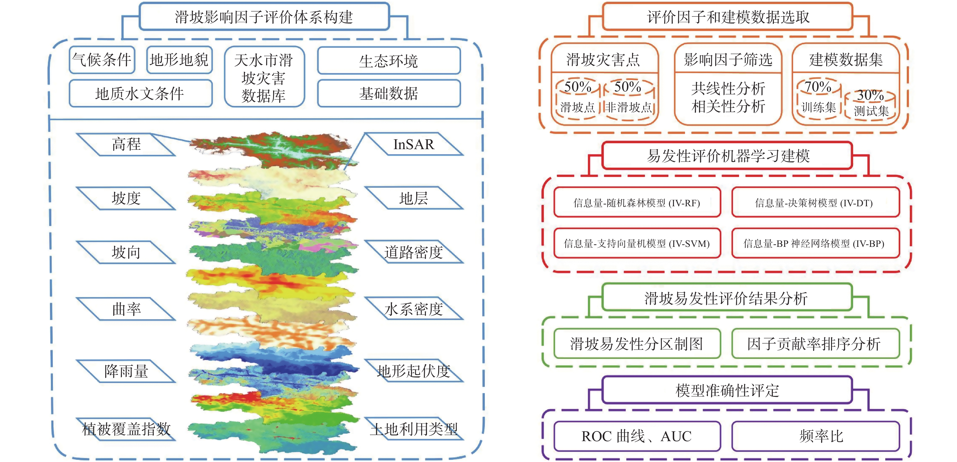
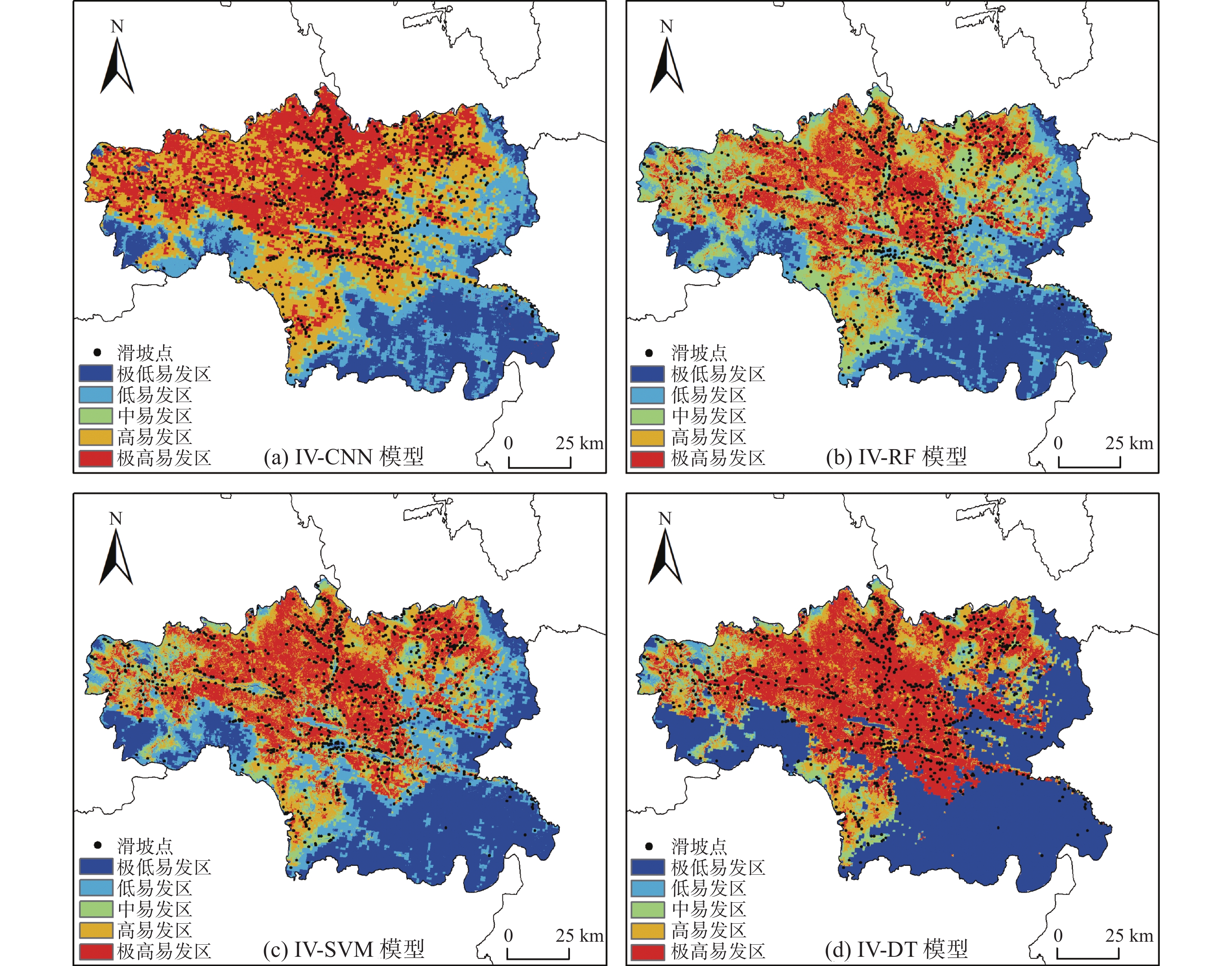
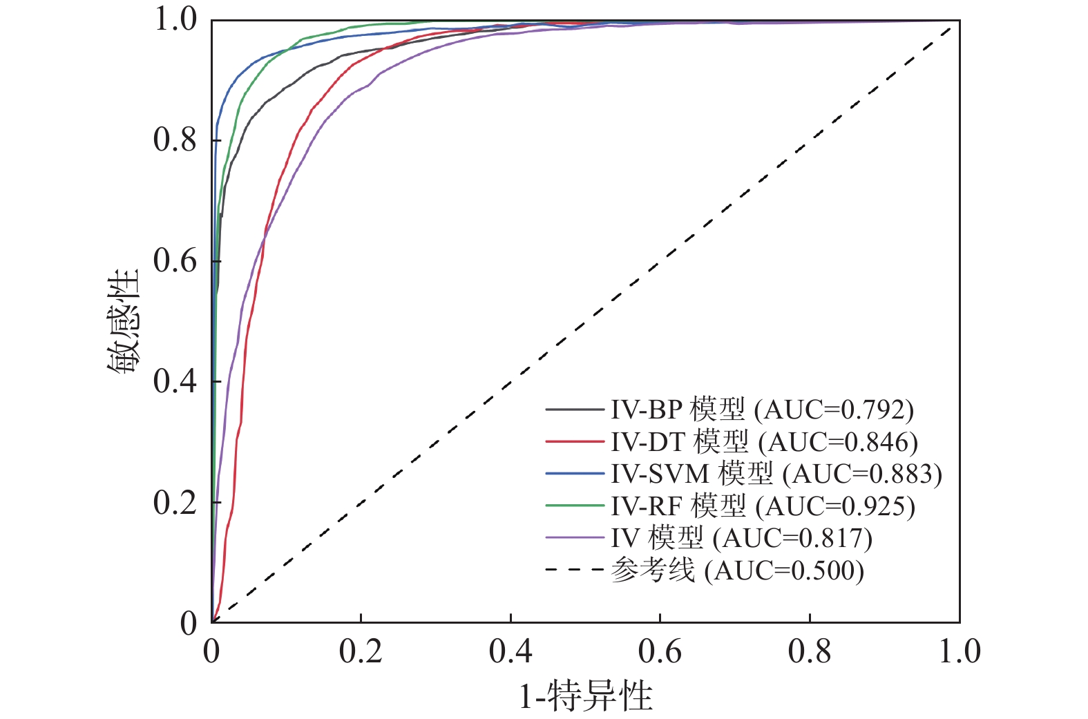
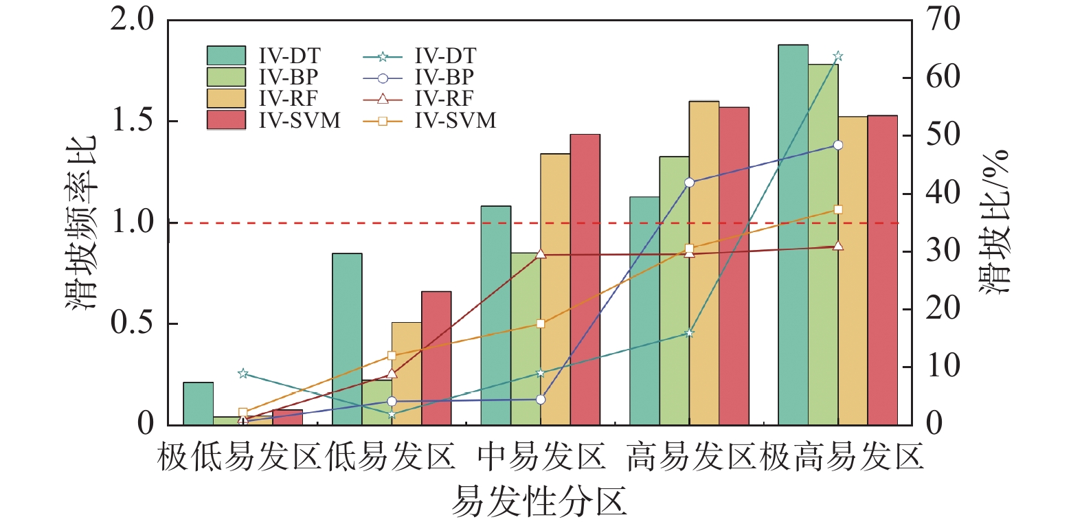
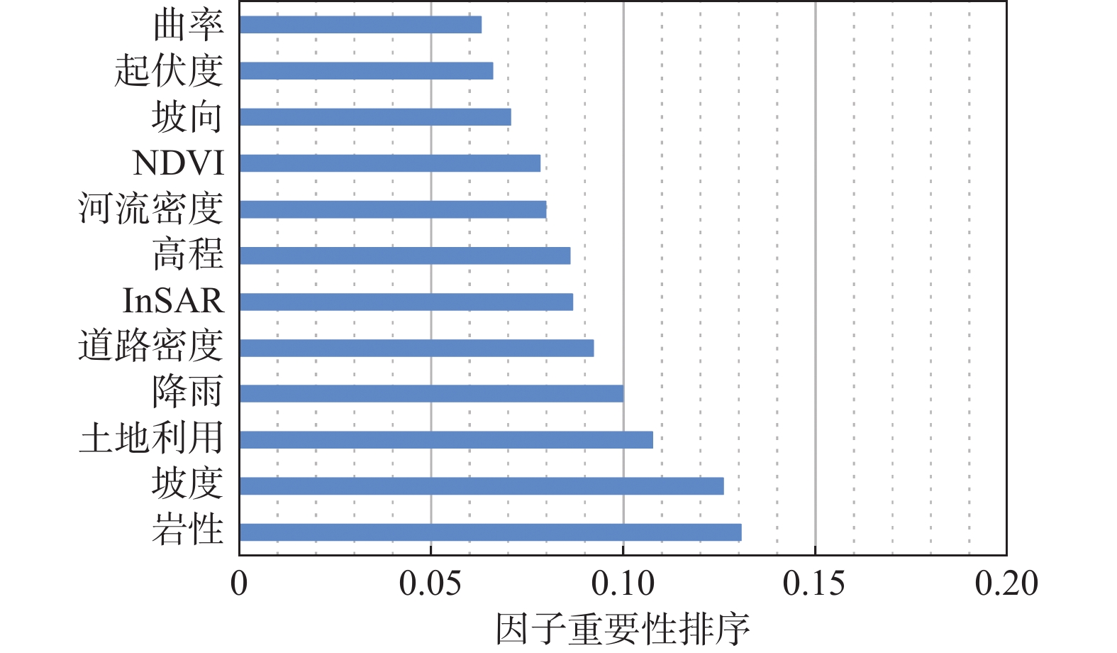
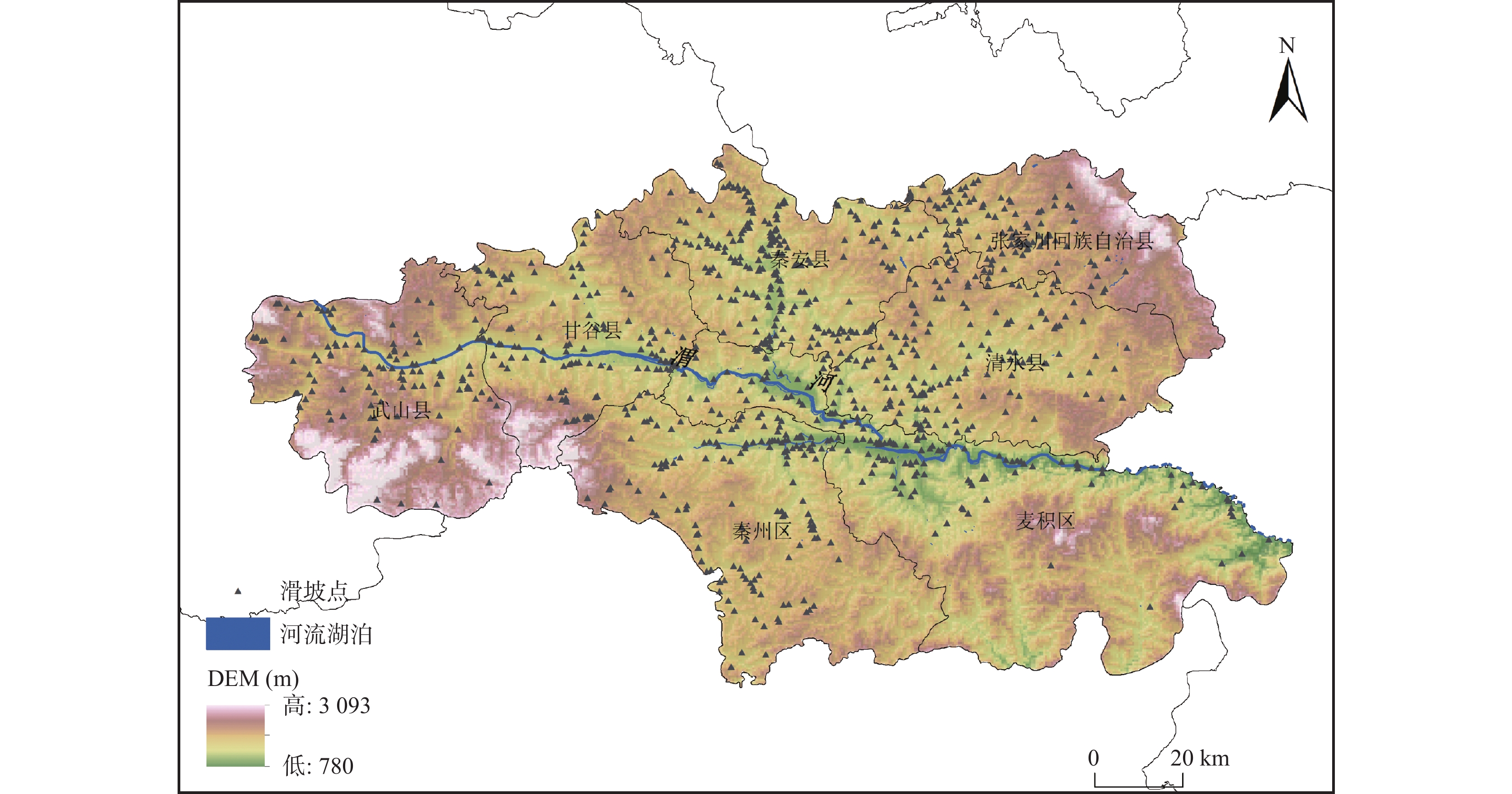
环境因子、气象因子与人类活动之间的相互作用,影响地表形态的变化。尤其对于黄土高原区域,在诸多因子的复杂互馈作用下易导致黄土崩滑灾害,亟需选择适用的影响因子和训练模型开展滑坡易发性评价研究。本研究以天水市为研究区,基于InSAR获取的地表形变信息,综合地形、水文、气候、生态以及人类活动等诸多影响因素,采用信息量模型(IV)分别联接到随机森林模型(RF)、决策树模型(DT)、支持向量机模型(SVM)和BP神经网络模型(BP)构建耦合模型IV-RF、IV-DT、IV-SVM和IV-BP,开展滑坡易发性评价研究。结果表明:耦合模型(IV-RF、IV-DT、IV-SVM和IV-BP)的 AUC 值分别为0.925、0.846、0.883、0.792,IV-RF具有更强的精度。滑坡频率比IV-RF模型从极低易发分区向极高易发区逐渐递增,滑坡易发性分区结果更均匀平稳。IV-RF模型具有更强的预测能力和精度,更适合黄土滑坡地质灾害易发性评价。IV-RF 模型的极高、高、中、低、极低易发性区域面积占比分别为 20.45%、18.28%、22.27%、16.92、22.09%,主要分布在天水市北部地质环境复杂和人类活动强烈的山地、黄土梁峁地区。岩性、坡度、土地利用、降雨、道路密度、InSAR形变在贡献率分析中排在前6位,是影响滑坡发育的主控因子。本研究旨在为黄土高原滑坡灾害的预测和防治工作提供可靠的科学依据,为滑坡易发性评价研究深化建模思路,优化独立模型评价结果不确定性问题。
Abstract:The interaction between environmental factors, meteorological factors, and human activities affects surface morphology change. Especially for the Loess Plateau region, it is easy to cause a loess slide disaster under the complex interaction of many factors, so selecting suitable influencing factors and training models to conduct landslide susceptibility evaluation research is urgent. This study takes Tianshui City as the research area and constructs a multi-factor evaluation system covering terrain scale, basic environmental factors, and human activity scale based on the surface deformation information obtained by InSAR. The coupled models IV-RF, IV-DT, IV-SVM, and IV-BP were constructed by connecting the information content model (IV) to the random forest model (RF), decision tree model (DT), support vector machine model (SVM) and BP neural network model (BP), and the landslide susceptibility evaluation was carried out. The results show that the AUC values of the coupled models (IV-RF, IV-DT, IV-SVM, and IV-BP) are 0.925, 0.846, 0.883, and 0.792, respectively, and IV-RF has stronger accuracy. Compared with the IV-RF model, the landslide frequency gradually increases from the very low prone zone to the very high prone zone, and the results of the landslide-prone zone are more uniform and stable. The IV-RF model has stronger prediction ability and accuracy and is more suitable for evaluating the geological hazard susceptibility of loess landslides. The areas of extremely high, high, medium, low, and very low susceptibility in the IV-RF model accounted for 20.45%, 18.28%, 22.27%, 16.92 and 22.09%, respectively, which were mainly distributed in the mountainous and loess ridge areas with complex geological environment and strong human activities in the north of Tianshui City. Lithology, slope, land use, rainfall, road density, and InSAR deformation rank the top 6 in the contribution rate analysis and are the main controlling factors affecting landslide development. This study aims to provide a reliable scientific basis for predicting and preventing landslide disasters in the Loess Plateau, deepen the modeling ideas for evaluating landslide susceptibility, and optimize the uncertainty of independent model evaluation results.
-
Key words:
- loess plateau /
- susceptibility evaluation /
- information model /
- machine learning methods /
- InSAR
-

-
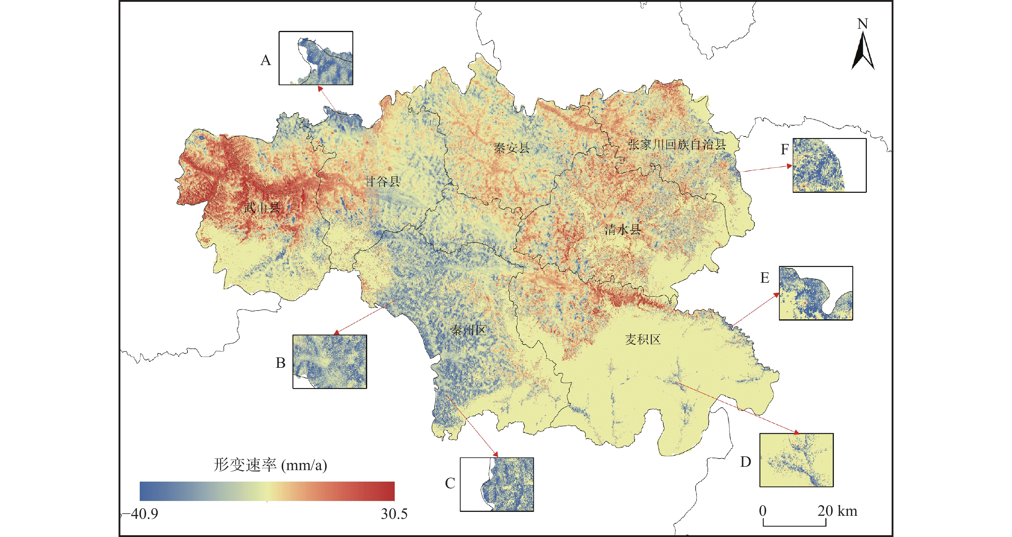
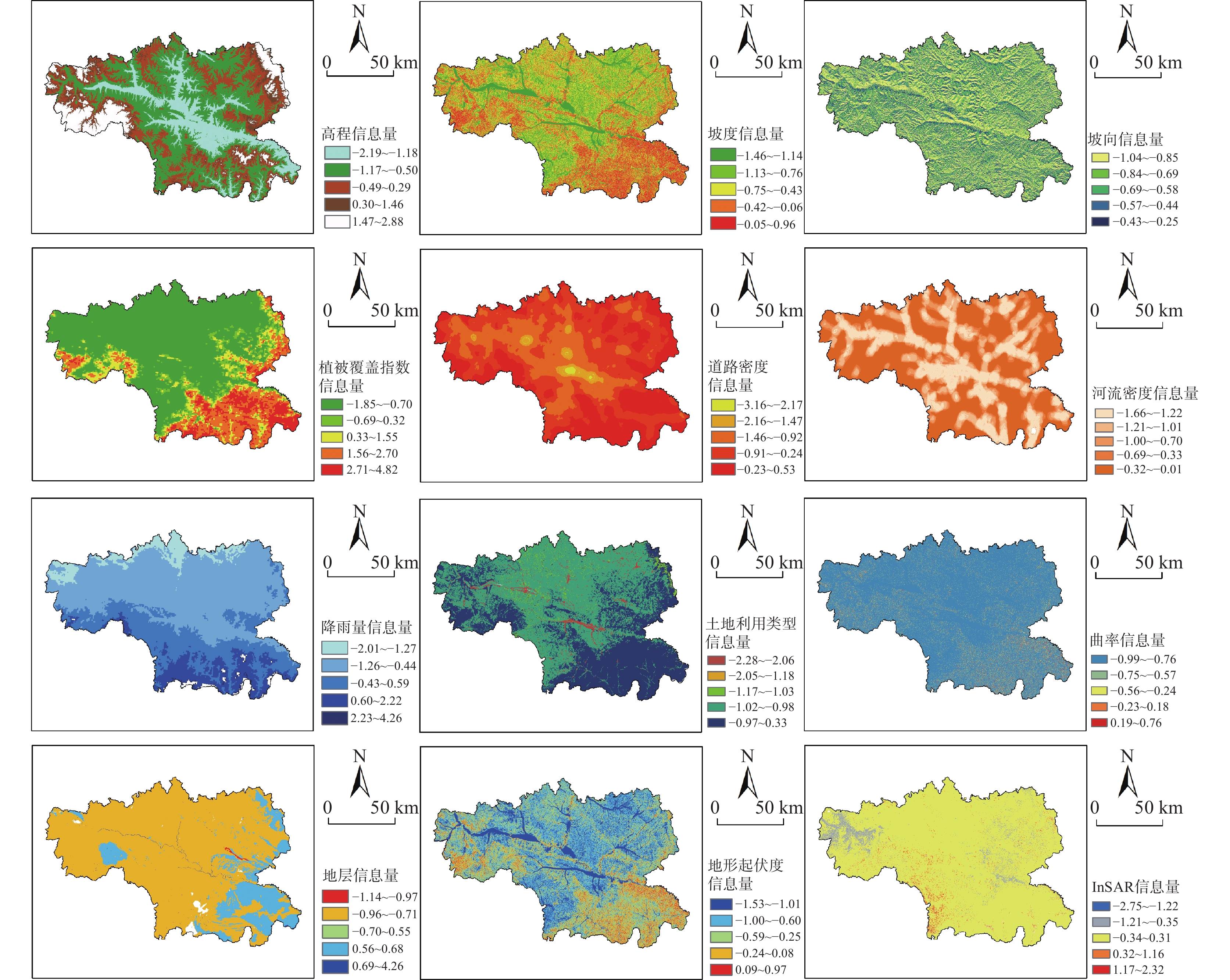
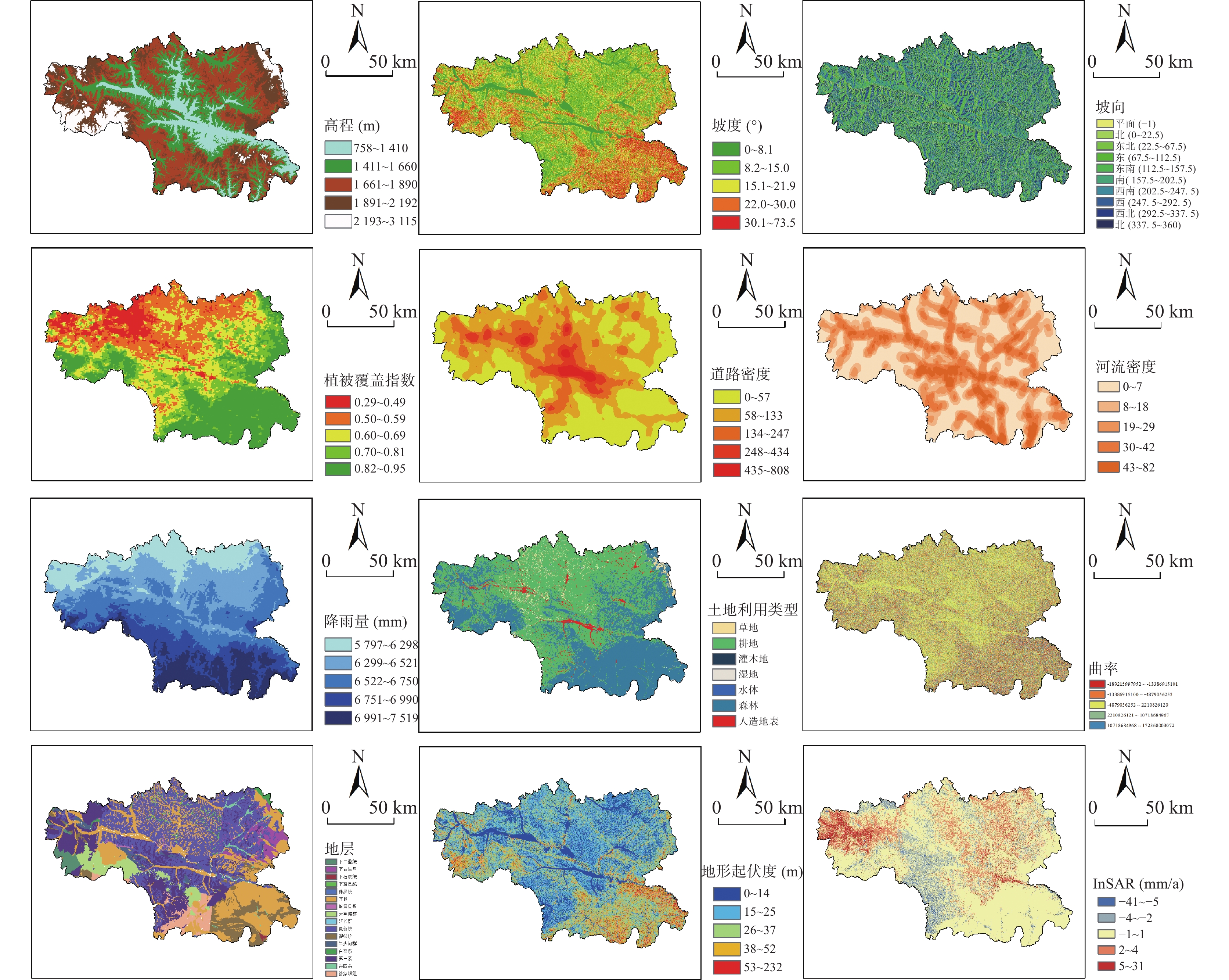
表 1 天水市滑坡易发性评价指标
Table 1. Evaluation index of landslide susceptibility in Tianshui City
目标层 准则层 方案层 滑坡易发性评价 地形地貌 地表形变;坡度;坡向;高程;曲率;地形起伏度 气候条件 降雨量 生态环境 土地利用类型;植被覆盖指数 地质水文 水系密度;地层岩性 基础数据 道路密度  下载: 导出CSV
表 2 评价因子相关性分析
Table 2. Correlation analysis of evaluation factors
岩性 土地利用 道路密度 河流密度 起伏度 坡向 坡度 NDVI 曲率 高程 降雨 InSAR 岩性 1 −0.013 0.042 0.003 −0.109 0.002 −0.002 0.031 0.090 0.011 0.113 0.108 土地利用 −0.013 1 −0.059 −0.054 0.100 −0.007 −0.019 −0.035 −0.154 0.013 −0.138 −0.179 道路密度 0.042 −0.059 1 0.256 −0.221 0.015 0.002 0.144 0.261 0.277 0.141 0.295 河流密度 0.003 −0.054 0.256 1 −0.260 0.009 0.022 0.110 0.384 0.219 0.223 0.368 起伏度 −0.109 0.100 −0.221 −0.260 1 0.010 −0.050 −0.115 −0.277 −0.088 −0.252 −0.180 坡向 0.002 −0.007 0.015 0.009 0.010 1 0.068 −0.001 −0.001 0.008 −0.001 −0.002 坡度 −0.002 −0.019 0.002 0.022 −0.050 0.068 1 0.009 0.046 −0.006 0.045 0.055 NDVI 0.031 −0.035 0.144 0.110 −0.115 −0.001 0.009 1 0.180 0.316 −0.152 0.181 曲率 0.090 −0.154 0.261 0.384 −0.277 −0.001 0.046 0.180 1 0.130 0.279 0.204 高程 0.011 0.013 0.277 0.219 −0.088 0.008 −0.006 0.316 0.130 1 −0.143 0.129 降雨 0.113 −0.138 0.141 0.223 −0.252 −0.001 0.045 −0.152 0.279 −0.143 1 0.347 InSAR 0.108 −0.179 0.295 0.368 −0.180 −0.002 0.055 0.181 0.204 0.129 0.347 1
下载: 导出CSV
表 3 不同模型滑坡易发性分区结果
Table 3. Landslide susceptibility zoning results of different models
模型 易发性分区 分区面积(km2) 分区面积占比(%) 滑坡数量(个) 滑坡数量占比(%) 滑坡密度(个/km2) IV-BP模型 极低易发区 2606.58 17.79 7 0.74 0.0027 低易发区 2636.73 18.00 40 4.23 0.0152 中易发区 766.125 5.23 43 4.55 0.0561 高易发区 4636.1025 31.65 397 42.01 0.0856 极高易发区 4003.155 27.33 458 48.47 0.1144 IV-RF模型 极低易发区 3235.7475 22.09 10 1.06 0.0031 低易发区 2478.06 16.92 84 8.89 0.0339 中易发区 3262.005 22.27 279 29.52 0.0855 高易发区 2677.275 18.28 280 29.63 0.1046 极高易发区 2995.605 20.45 292 30.90 0.0975 IV-SV模型 极低易发区 3882.1725 26.60 22 2.33 0.0057 低易发区 2495.61 17.10 114 12.09 0.0457 中易发区 1818.7425 12.46 166 17.60 0.0913 高易发区 2812.9275 19.28 289 30.65 0.1027 极高易发区 3582.7875 24.55 352 37.33 0.0982 IV-DT模型 极低易发区 5955.2325 40.81 85 9.01 0.0143 低易发区 333.81 2.29 19 2.01 0.0569 中易发区 1228.6125 8.42 86 9.12 0.0700 高易发区 2110.41 14.46 151 16.01 0.0716 极高易发区 4964.175 34.02 602 63.84 0.1213
下载: 导出CSV
-
[1] 陈丹璐, 孙德亮, 文海家, 等. 基于不同因子筛选方法的LightGBM-SHAP滑坡易发性研究[J]. 北京师范大学学报(自然科学版), 2024, 60(1): 148−158.
CHEN Danlu, SUN Deliang, WEN Haijia, et al. Study on landslide susceptibility of LightBM-SHAP based on different factor screening methods[J]. Journal of Beijing Normal University (Natural Science Edition),2024,60(1):148−158.
[2] 窦杰, 向子林, 许强, 等. 机器学习在滑坡智能防灾减灾中的应用与发展趋势[J]. 地球科学, 2023, 48(5): 1657−1674.
DOU Jie, XIANG Zilin, XU Qiang, et al. Application and development trend of machine learning in landslide intelligent disaster prevention and reduction[J]. Earth Science,2023,48(5):1657−1674.
[3] 杜鹏, 陈宁生, 伍康林, 等. 基于随机森林模型的藏东南地区滑坡易发性评价及主控因素分析[J]. 成都理工大学学报(自然科学版), 2024, 51(2): 328−344.
DU Peng, CHENG Ningsheng, WU Kanglin, et al. Evaluation of landslide susceptibility in southeast Tibet based on arandom forestmodel[J]. Journal of Chengdu University of Technology (Science & Technology Edition),2024,51(2):328−344.
[4] 盖侨侨, 孙倩, 张宁, 等. 融合时序InSAR形变的白银市地质灾害易发性评价[J]. 武汉大学学报(信息科学版), 2024, 49(8): 1434−1443.
GAI Qiaoqiao, SUN Qian, ZHANG Ning, et al. Geological hazard susceptibility evaluation of Baiyin City based on time-series InSAR deformation[J]. Journal of Wuhan University (Information Science Edition),2024,49(8):1434−1443.
[5] 胡祥祥, 明璐璐, 吴涛, 等. 融合InSAR与信息量-层次分析耦合模型的西宁市地质灾害易发性评价[J]. 测绘通报, 2023(12): 51−56+75.
HU Xiangxiang, MING Lulu, WU Tao, et al. Geological hazard susceptibility evaluation of Xining City by combining InSAR and information-hierarchy analysis coupling model[J]. Bulletin of Surveying and Mapping,2023(12):51−56+75.
[6] 黄发明, 李金凤, 王俊宇, 等. 考虑线状环境因子适宜性和不同机器学习模型的滑坡易发性预测建模规律[J]. 地质科技通报, 2022, 41(2): 44−59.
HUANG Faming, LI Jinfeng, WANG Junyu, et al. Landslide susceptibility prediction modeling law considering the suitability of linear environmental factors and different machine learning models[J]. Bulletin of Geological Science and Technology,2022,41(2):44−59.
[7] 黄龙, 孙倩, 胡俊. 基于InSAR与随机森林的滑坡敏感性评价与误差改正[J]. 测绘通报, 2022(10): 13−20.
HUANG Long, SUN Qian, HU Jun. Landslide sensitivity evaluation and error correction based on InSAR and Random forest[J]. Bulletin of Surveying and Mapping,2022(10):13−20.
[8] 贾俊, 毛伊敏, 孟晓捷, 等. 深度随机森林和随机森林算法的滑坡易发性评价对比——以汉中市略阳县为例[J]. 西北地质, 2023, 56(3): 239−249.
JIA Jun, MAO Yinmin, MENG Xiaojie, et al. Comparison of landslide susceptibility evaluation between deep random forest and random forest algorithm: A case study of Qingyang County, Hanzhong City[J]. Northwestern Geology,2023,56(3):239−249.
[9] 柯福阳, 胡祥祥, 明璐璐, 等. 面向地表形变高精度监测的GNSS-InSAR融合方法[J]. 遥感技术与应用, 2023, 38(5): 1028−1041.
KE Fuyang, HU Xiangxiang, MING Lulu, et al. A GNSS-InSAR fusion method for high-precision surface deformation monitoring[J]. Remote Sensing Technology and Application,2023,38(5):1028−1041.
[10] 孔嘉旭, 庄建琦, 彭建兵, 等. 基于信息量和卷积神经网络的黄土高原滑坡易发性评价[J]. 地球科学, 2023, 48(5): 1711−1729.
KONG Jiaxu, ZHUANG Jianqi, PENG Jianbing, et al. Evaluation of landslide vulnerability in Loess Plateau based on information and convolutional neural networks[J]. Earth Science,2023,48(5):1711−1729.
[11] 李成林, 刘严松, 赖思翰, 等. 基于BP神经网络模型的滑坡易发性评价方法[J]. 科学技术与工程, 2023, 23(13): 5481−5492.
LI Chenglin, LIU Yansong, LAI Sihan, et al. Landslide susceptibility evaluation method based on BP neural network model[J]. Science Technology and Engineering,2023,23(13):5481−5492.
[12] 李晶, 朱武, 张关龙, 等. 基于InSAR和热点分析技术的黄土高原地质灾害隐患识别[J/OL]. 工程地质学报, 2022, 1−17. doi: 10.13544/j.cnki.jeg.2022-0444.
LI Jin,ZHU Wu,ZHANG Guanlong,et al. Potential geological hazard identification in Loess Plateau based on InSAR and hot spot analysis techniques [J/OL]. Journal of Engineering Geology, 2022, 1−17. doi:10.13544/j.cnki.jeg.2022-0444.
[13] 李萍, 叶辉, 谈树成. 基于层次分析法的永德县地质灾害易发性评价[J]. 水土保持研究, 2021, 28(5): 394−399.
LI Ping, YE Hui, TAN Shucheng. Geological hazard susceptibility evaluation based on analytic hierarchy process in Yongde County[J]. Research of Soil and Water Conservation,2021,28(5):394−399.
[14] 李益敏, 向倩英, 邓选伦, 等. 基于优化 MaxEnt 模型的怒江州滑坡易发性评价[J/OL]. 河南理工大学学报(自然科学版), 2024, 1−11. doi: 10.16186/j.cnki.1673-9787.2023070010.
LI Yimin,XIANG Qianying,DENG Xuanlun,et al. Evaluation of landslide vulnerability in Nujiang Prefecture based on optimized MaxEnt model [J/OL]. Journal of Henan Polytechnic University (Natural Science Edition),2024,1−11. doi:10.16186/j.cnki.1673-9787.2023070010.
[15] 李泽芝, 王新刚. 镇域尺度下秦巴山区堆积层滑坡易发性不同单元评价性能对比研究[J]. 西北地质, 2024, 57(1): 1−11.
LI Zezhi, WANG Xingang. Comparative study on evaluation performance of different units for landslide susceptibility of accumulative strata in Qinba Mountain area at township scale [J]. Northwestern Geology, 2024, 57 (1): 1−11.
[16] 林琴, 郭永刚, 吴升杰, 等. 基于梯度提升的优化集成机器学习算法对滑坡易发性评价: 以雅鲁藏布江与尼洋河两岸为例[J]. 西北地质, 2014, 57(1): 12−22.
LIN Qin, GUO Yonggang, WU Shengjie, et al. Evaluation of landslide susceptibility by an optimized integrated machine learning algorithm based on gradient lifting: A case study of the two banks of the Yarlung Zangbo River and the Niyang River[J]. Northwest Geology,2014,57(1):12−22.
[17] 林炫歆, 肖桂荣, 周侯伯. 顾及土地利用动态变化的滑坡易发性评估方法[J]. 地球信息科学学报, 2023, 25(5): 953−966. doi: 10.12082/dqxxkx.2023.220567
LIN Xuanxin, XIAO Guirong, ZHOU Houbo. Landslide susceptibility assessment method considering land use dynamic change[J]. Journal of Geo-Information Science,2023,25(5):953−966. doi: 10.12082/dqxxkx.2023.220567
[18] 刘福臻, 王灵, 肖东升. 机器学习模型在滑坡易发性评价中的应用[J]. 中国地质灾害与防治学报, 2021, 32(6): 98−106.
LIU Fuzhen, WANG Ling, XIAO Dongsheng. Application of machine learning model in landslide susceptibility evaluation[J]. Chinese Journal of Geological Hazards and Control,2021,32(6):98−106.
[19] 刘帅, 朱杰勇, 杨得虎, 等. 不同降雨工况条件下的崩滑地质灾害危险性评价[J]. 地质科技通报, 2024, 43(2): 253−267.
LIU Shuai, ZHU Jieyong, YANG Dehu, et al. Risk assessment of landslide geological hazards under different rainfall conditions[J]. Bulletin of Geological Science and Technology,2024,43(2):253−267.
[20] 卢星宇. 基于InSAR技术的九寨沟地质灾害危险性评价研究[D]. 成都: 电子科技大学, 2021.
LU Xingyu. Research on geological hazard assessment of Jiuzhaigou Valley based on InSAR technology [D]. Chengdu:University of Electronic Science and Technology of China, 2021.
[21] 谭翠, 黄钦, 杨波, 等. 随机森林算法在区域生态旅游适宜性评价中的应用研究[J]. 地球信息科学学报, 2024, 26(2): 318−331. doi: 10.12082/dqxxkx.2024.230198
TAN Cui, HUANG Qin, YANG Bo, et al. Application of random forest algorithm in regional ecotourism suitability evaluation[J]. Journal of Geoinformation Science,2024,26(2):318−331. doi: 10.12082/dqxxkx.2024.230198
[22] 王本栋, 李四全, 许万忠, 等. 基于 3 种不同机器学习算法的滑坡易发性评价对比研究[J]. 西北地质, 2024, 57(1): 34−43.
WANG Bendong, LI Siquan, XU Wanzhong, et al. Comparative study on landslide susceptibility evaluation based on Three different machine learning algorithms [J]. Northwestern Geology, 2019, 57 (1): 34−43.
[23] 王瑞琪, 王学良, 刘海洋, 等. 基于精细 DEM 的崩塌滑坡灾害识别及主控因素分析——以雅鲁藏布江缝合带加查-朗县段为例[J]. 工程地质学报, 2019, 27(5): 1146−1152.
WANG Ruiqi, WANG Xueliang, LIU Haiyang, et al. Landslide hazard identification and main control factors analysis based on fine DEM: A case study of Jiacha-Lang County section of Yarlung Zangbo River suture zone[J]. Journal of Engineering Geology,2019,27(5):1146−1152.
[24] 魏文豪, 贾雨霏, 盛逸凡, 等. 基于I、SVM、I-SVM的滑坡灾害易发性评价模型研究[J]. 安全与环境工程, 2023, 30(3): 136−144.
WEI Wenghao, JIA Yufei, SHENG Yifan, et al. Research on landslide hazard susceptibility evaluation model based on I, SVM and I-SVM[J]. Safety and Environmental Engineering,2023,30(3):136−144.
[25] 武雪玲, 杨经宇, 牛瑞卿. 一种结合SMOTE和卷积神经网络的滑坡易发性评价方法[J]. 武汉大学学报(信息科学版), 2020, 45(8): 1223−1232.
WU Xueling, YANG Jingyu, NIU Ruiqing. A landslide susceptibility evaluation method with SMOTE and Convolutional neural network[J]. Journal of Wuhan University (Information Science Edition),2020,45(8):1223−1232.
[26] 徐胜华, 刘纪平, 王想红, 等. 熵指数融入支持向量机的滑坡灾害易发性评价方法——以陕西省为例[J]. 武汉大学学报(信息科学版), 2020, 45(8): 1214−1222.
XU Shenghua, LIU Jiping, WANG Xianghong, et al. Landslide hazard susceptibility evaluation method based on entropy index integrated with support vector machine: A case study of Shaanxi Province[J]. Journal of Wuhan University (Information Science Edition),2020,45(8):1214−1222.
[27] 吴铭洋, 陈宁生, 杨溢, 等. 三工河小流域泥石流生态—岩土工程调控措施减缓土壤侵蚀的定量研究[J]. 成都理工大学学报(自然科学版), 2024, 51(1): 117−129.
WU Mingyang, CHEN Ningsheng, YANG Yi, et al. Quantitative study on the mitigation of soil erosion by comprehensive ecological and geotechnical debris flow treatment measures in small basins: A case study of the Sangong River Basin[J]. Journal of Chengdu University of Technology (Science & Technology Edition),2024,51(1):117−129.
[28] 许强, 陈婉琳, 蒲川豪, 等. 基于自然的解决方案在黄土高原重大工程灾变防控中的理论与实践[J]. 工程地质学报, 2022, 30(4): 1179−1192.
XU Qiang, CHEN Wanling, PU Chuanhao, et al. Theory and practice of nature-based solutions in disaster prevention and control of major projects on the Loess Plateau[J]. Journal of Engineering Geology,2022,30(4):1179−1192.
[29] 杨根云, 周伟, 方教勇. 基于信息量模型和数据标准化的滑坡易发性评价[J]. 地球信息科学学报, 2018, 20(5): 674−683. doi: 10.12082/dqxxkx.2018.170535
YANG Genyun, ZHOU Wei, FANG Jiaoyong. Landslide susceptibility evaluation based on information model and data standardization[J]. Journal of Geoinformation Science,2018,20(5):674−683. doi: 10.12082/dqxxkx.2018.170535
[30] 杨畅, 赵建军, 王寿宇, 等. 基于MatDEM的易贡滑坡铲刮效应研究[J]. 成都理工大学学报(自然科学版), 2024, 51(3): 477−488.
YANG Chang, ZHAO Jianjun, WANG Shouzi, et al. MatDEM-based investigation of shovel-scraping effect on Yigongland slidel[J]. Journal of Chengdu University of Technology (Science & Technolgy Edition),2024,51(3):477−488.
[31] 赵永辉. 雅鲁藏布江公路滑坡发育特征及破坏机理研究[J]. 公路, 2021, 66(4): 6−10.
ZHAO Yonghui. Development characteristics and failure mechanism of highway landslide in Yarlung Zangbo River[J]. Highway,2021,66(4):6−10.
[32] 赵占骜, 王继周, 毛曦, 等. 多维CNN耦合的滑坡易发性评价方法[J]. 武汉大学学报(信息科学版), 2024, 49(8): 1466−1481.
ZHAO Zhanao, WANG Jizhou, MAO Xi, et al. Landslide susceptibility evaluation method based on multi-dimensional CNN coupling[J]. Journal of Wuhan University (Information Science Edition),2024,49(8):1466−1481.
[33] 周超, 甘露露, 王悦, 等. 综合非滑坡样本选取指数与异质集成机器学习的区域滑坡易发性建模[J]. 地球信息科学学报, 2023, 25(8): 1570−1585.
ZHOU Chao, GAN Lulu, WANG Yue, et al. Regional landslide susceptibility modeling based on non-landslide sample selection index and heterogeneous integrated machine learning[J]. Journal of Geoinformation Science,2023,25(8):1570−1585.
[34] 朱怡飞, 姚鑫, 姚磊华, 等. 基于InSAR和光学遥感的贵州鬃岭采煤滑坡识别与危险性评价[J]. 地质力学学报, 2022, 28(2): 268−280.
ZHU Yifei, YAO Xin, YAO Leihua, et al. Identification and risk assessment of coal mining landslide in Ziling, Guizhou Province based on InSAR and optical remote sensing[J]. Chinese Journal of Geomechanics,2022,28(2):268−280.
[35] Ayalew L, Yamagishi H. The application of GIS-based logistic regression for landslide susceptibility mapping in the KakudaYahiko Mountains, Central Japan[J]. Geomorphology,2005,65(1):15−31.
[36] Dou J, Ali P Y, Dieu T B, et al. Improved landslide assessment using support vector machine with bagging, boosting, and stacking ensemble machine learning framework in a mountainous watershed, Japan[J]. Landslides, 2020, 17(3).641−658
[37] Jiang N, Li Y, Han Z, et al. A dataset-enhanced Linformer model for geo-hazards susceptibility assessment: a case study of the railway in Southwest China[J]. Environmental Earth Sciences, 2023, 82(17).
[38] Jin B, Zeng T, Yin K, et al. Dynamic landslide susceptibility mapping based on the PS-InSAR deformation intensity[J]. Environmental Science and Pollution Research, 2024: 1−17.
[39] Li W B, Fan X M, Huang F M, et al. Uncertainties of landslide susceptibility modeling under different environmental factor connections and prediction models[J]. Earth Science,2021,46(10):3777−3795.
[40] Zhang Y, Chen Y Y, Ming D P, et al. Landslide hazard analysis based on SBAS-InSAR and MCE-CNN model: a case study of Kongtong, Pingliang[J]. Geocarto International,2023,38(1):1−22.
-

图(10)
表(3)
计量
- 文章访问数: 496
- PDF下载数: 0
- 施引文献: 0