

RISK ASSESSMENT OF LANDSLIDE DISASTERS IN THE UPPER REACHES OF YAJIANG COUNTY, SICHUAN PROVINCE
-
摘要:
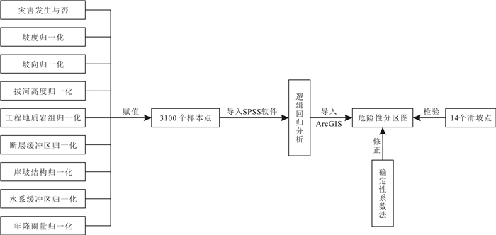
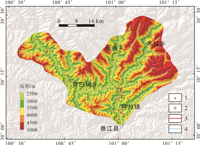
雅江县位于四川省西部雅砻江中游河段,以中山-高山峡谷地貌为主,地质灾害频发.为保障人民生命财产安全,基于逻辑回归与确定性系数叠加分析,进行雅江县上游河段滑坡灾害危险性评价.结果表明:1)雅江县上游河段滑坡极易发生在海拔2 500~3 000 m、拔河高度600~900 m、坡度30~45°、距离河流水系0~200 m范围较硬岩夹较软岩类地带;2)雅江县上游河段高危险区、极高危险区面积占总面积的46.75%,发生滑坡占滑坡总数的65.91%,说明该区域内滑坡分布密集,危害程度相对较高,与野外实际调查结果相符;3)雅江县上游河段呷拉镇一带多属极高危险区、高危险区,瓦多乡一带多属中等危险区,木绒乡、普巴绒乡一带多属低危险区、极低危险区;4)通过查验点及ROC曲线对评价结果验证,该评价结果有较高的准确性,能够作为研究区防灾减灾与河谷开发利用的合理方案依据.
Abstract:Yajiang County, located in the middle reaches of Yalong River in western Sichuan Province, is dominated by the landform of middle mountain-alpine valley, with frequent geological disasters. The risk assessment of landslide disasters in the upper reaches of Yajiang County is carried out on the basis of overlay analysis of logistic regression (LR) and certainty factor (CF) to ensure people's life and property security. The results show that the landslides are prone to occur in the hard rock interbedded with soft rock zone, with an altitude of 2 500-3 000 m, relative height above river of 600-900 m, gradient of 30-45° and distance of 0-200 m from river system. The high and very high risk areas in the upper reaches of Yajiang County account for 46.75% of the total area, and 65.91% of the total landslide occurrences, indicating the dense distribution of landslides and high damage degree, which is consistent with the field survey results. The Xiala Town mostly belongs to very high and high risk area, Waduo Township mostly medium risk area, and Murong Township and Pubarong Township mostly low and very low risk area. The assessment results have high accuracy through verification of inspection points and ROC curve, and thus can serve as a reasonable plan basis for disaster prevention and mitigation, river development and utilization in the study area.
-

-
表 1 评价指标归一化值计算表
Table 1. Calculation results for normalized value of evaluation indexes
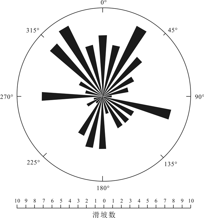
评价指标 指标分级 滑坡面积/km2 评价指标面积/km2 Rij Xij 坡度/(°) 0~15 6.13 194.12 0.032 0.199 15~30 21.87 597.43 0.037 0.231 30~45 37.54 765.32 0.049 0.309 45~60 8.36 201.96 0.041 0.261 60~75 0.00 5.03 0.000 0.000 坡向 北(0~22.5°,337.5~360°) 11.16 200.18 0.056 0.162 北东(22.5~67.5°) 6.01 194.32 0.031 0.090 东(67.5~112.5°) 3.77 213.46 0.018 0.051 南东(112.5~157.5°) 5.03 247.63 0.020 0.059 南(157.5~202.5°) 11.93 218.62 0.055 0.159 南西(202.5~247.5°) 9.34 211.34 0.044 0.128 西(247.5~292.5°) 16.05 210.55 0.076 0.221 北西(292.5~337.5°) 11.95 267.76 0.045 0.130 拔河高度/m 0~300 26.50 249.31 0.106 0.325 300~600 19.26 433.68 0.044 0.136 600~900 23.52 452.01 0.052 0.159 900~1200 63.98 531.78 0.120 0.368 1200~1800 0.37 97.08 0.004 0.012 工程地质岩组 较软岩类 3.96 190.03 0.021 0.188 较软岩夹较硬岩类 16.71 774.37 0.022 0.195 较硬岩夹较软岩类 53.23 778.79 0.068 0.617 坚硬岩类 0.00 20.67 0.000 0.000 断裂带距离/m 0~1000 2.02 45.34 0.045 0.199 1000~2000 4.20 49.76 0.084 0.377 2000~3000 0.48 53.30 0.009 0.040 3000~4000 2.60 58.52 0.044 0.198 >4000 64.60 1556.94 0.041 0.185 岸坡结构 顺向坡 24.85 292.31 0.085 0.483 斜向坡 27.67 618.31 0.045 0.254 横向坡 16.55 579.12 0.029 0.162 逆向坡 4.83 274.12 0.018 0.100 河流水系/m 0~200 48.14 382.31 0.126 0.630 200~400 16.54 338.62 0.049 0.245 400~600 6.27 298.31 0.021 0.105 >600 2.95 744.62 0.004 0.020 年平均降雨量/mm 610 0.16 192.92 0.001 0.008 630 7.25 230.95 0.031 0.303 760 3.35 277.58 0.012 0.116 780 63.14 1062.23 0.059 0.573  下载: 导出CSV
表 2 回归系数计算结果
Table 2. Calculation results of regression coefficient
坡度 坡向 拔河高度 工程地质岩组 断裂带 岸坡结构 河流水系 降雨 常数 1.809 1.116 2.015 2.684 6.884 2.663 2.362 3.047 -5.894
下载: 导出CSV
表 3 各个评价指标的确定性系数权值
Table 3. Certainty factor weights of evaluation indexes
评价指标 指标分级 CF Wci Pij 确定性权排名 评价指标 指标分级 CF Wci Pij 确定性权排名 坡度/(°) 0~15 0.4375 0.0833 0.0365 25 工程地质岩组 较软岩类 0.4010 0.2003 0.0803 9 15~30 0.5382 0.0833 0.0449 16 较软岩夹较硬岩类 0.0760 0.2003 0.0152 31 30~45 0.6887 0.0833 0.0574 13 较硬岩夹较软岩类 0.8994 0.2003 0.1802 1 45~60 0.8172 0.0833 0.0681 12 坚硬岩类 -1.0000 0.2003 -0.2003 39 断层缓冲区/m 0~1000 -0.5737 0.1789 -0.1027 38 60~75 -1.0000 0.0833 -0.0833 35 1000~2000 0.2003 0.1789 0.0358 26 坡向 北(0~22.5°,337.5~360°) 0.7444 0.0587 0.0437 18 2000~3000 -0.4910 0.1789 -0.0879 36 北东(22.5~67.5°) 0.7049 0.0587 0.0414 19 3000~4000 0.0000 0.1789 0.0000 33 东(67.5~112.5°) 0.5461 0.0587 0.0320 28 >4000 0.7917 0.1789 0.1417 2 岸坡结构 顺向坡 0.7500 0.1308 0.0981 6 南东(112.5~157.5°) 0.4995 0.0587 0.0293 29 逆向坡 0.3087 0.1308 0.0404 20 南(157.5~202.5°) 0.6712 0.0587 0.0394 21 横向坡 0.7672 0.1308 0.1003 5 南西(202.5~247.5°) 0.1570 0.0587 0.0092 32 斜向坡 0.5812 0.1308 0.0760 10 西(247.5~292.5°) 0.5818 0.0587 0.0341 27 水系缓冲区/m 0~200 0.7617 0.0506 0.0385 23 北西(292.5~337.5°) 0.7451 0.0587 0.0437 17 200~400 0.7781 0.0506 0.0394 22 拔河高度/m 0~300 0.9428 0.1308 0.1233 3 400~600 0.7552 0.0506 0.0382 24 300~600 0.4299 0.1308 0.0562 14 >600 -0.0988 0.0506 -0.0050 34 年平均降雨量/mm 610 0.1111 0.0506 -0.0898 37 600~900 0.5382 0.1308 0.0704 11 630 0.4946 0.1111 0.0550 15 900~1200 0.7387 0.1308 0.0966 7 760 0.2362 0.1111 0.0262 30 1200~1800 0.8861 0.1308 0.1159 4 780 0.8525 0.1111 0.0947 8
下载: 导出CSV
表 4 查验点分布统计表
Table 4. Risk zoning and number of landslide disaster inspection points
危险性等级 滑坡数量/个 极低危险区 0 低危险区 0 中等危险区 4 高危险区 6 极高危险区 4
下载: 导出CSV
表 5 滑坡灾害危险性评价结果统计表
Table 5. Risk evaluation results of landslide disaster
危险性分区 面积/km2 滑坡面积/km2 滑坡面密度/% 占滑坡总数比例/% 极高危险区 303.64 23.59 7.77 27.19 高危险区 520.94 30.49 5.85 37.72 中等危险区 361.33 14.06 3.89 20.18 低危险区 376.58 5.82 1.55 13.16 极低危险区 201.34 0.24 0.12 1.75
下载: 导出CSV
-
[1] 黄润秋. 20世纪以来中国的大型滑坡及其发生机制[J]. 岩石力学与工程学报, 2007, 26(3): 433-454. doi: 10.3321/j.issn:1000-6915.2007.03.001
Huang R Q. Large-scale landslides and their sliding mechanisms in China since the 20th Century[J]. Chinese Journal of Rock Mechanics and Engineering, 2007, 26(3): 433-454. doi: 10.3321/j.issn:1000-6915.2007.03.001
[2] 许强, 黄润秋, 向喜琼. 地质灾害发生时间和空间的预测预报[J]. 山地学报, 2000, 18(S1): 112-117. https://www.cnki.com.cn/Article/CJFDTOTAL-SDYA2000S1024.htm
Xu Q, Huang R Q, Xiang X Q. Time and spacial predicting of geological hazards occurrence[J]. Journal of Mountain Science, 2000, 18(S1): 112-117. https://www.cnki.com.cn/Article/CJFDTOTAL-SDYA2000S1024.htm
[3] 王荐霖. 岷江上游汶川-松潘河段大型滑坡发育特征及危险性评价[D]. 成都: 成都理工大学, 2019.
Wang J L. Research on development characteristics and hazard assessment of large-scale landslide in Minjiang River from Wenchuan to Songpan[D]. Chengdu: Chengdu University of Technology, 2019.
[4] 倪化勇, 王德伟, 陈绪钰, 等. 四川雅江县城地质灾害发育特征与稳定性评价[J]. 现代地质, 2015, 29(2): 474-480. doi: 10.3969/j.issn.1000-8527.2015.02.036
Ni H Y, Wang D W, Chen X Y, et al. Formation characteristics and stability assessment of geological hazards in Yajiang City, Sichuan Province[J]. Geoscience, 2015, 29(2): 474-480. doi: 10.3969/j.issn.1000-8527.2015.02.036
[5] 毛硕. 基于GIS的薛城地区滑坡地质灾害危险性评价[D]. 成都: 成都理工大学, 2016.
Mao S. Hazard assessment of landslide geological disaster in Xuecheng area based on GIS[D]. Chengdu: Chengdu University of Technology, 2016.
[6] 许冲. 汶川地震滑坡分布规律与危险性评价[J]. 岩石力学与工程学报, 2012, 31(2): 432. doi: 10.3969/j.issn.1000-6915.2012.02.024
Xu C. Distribution law and risk assessment for Wenchuan earthquake-triggered landslides[J]. Chinese Journal of Rock Mechanics and Engineering, 2012, 31(2): 432. doi: 10.3969/j.issn.1000-6915.2012.02.024
[7] 邢秋菊, 赵纯勇, 高克昌, 等. 基于GIS的滑坡危险性逻辑回归评价研究[J]. 地理与地理信息科学, 2004, 20(3): 49-51. doi: 10.3969/j.issn.1672-0504.2004.03.011
Xing Q J, Zhao C Y, Gao K C, et al. Logical regression analysis on the hazard of landslide based on GIS[J]. Geography and Geo-Information Science, 2004, 20(3): 49-51. doi: 10.3969/j.issn.1672-0504.2004.03.011
[8] 李翔. 以绥德县为例基于ArcGIS及逻辑回归法的地质灾害危险性评价[D]. 西安: 长安大学, 2015.
Li X. Evaluation of geological hazard zonation based on ArcGIS and logistic regression[D]. Xi'an: Chang'an University, 2015.
[9] 王鹏. 基于逻辑回归与GIS的青海省尖扎县区域滑坡危险性评价[D]. 北京: 中国地质大学(北京), 2017.
Wang P. Regional slide hazard assessment based on logistic analysis and GIS in Jianzha County, Qinghai Province[D]. Beijing: China University of Geosciences, 2017.
[10] 侯兴利, 陈建勋, 张恋. 基于ArcGIS的滑坡空间分布的变维分形研究——以江西省宁都县为例[J]. 地质与资源, 2019, 29(3): 293-297. doi: 10.3969/j.issn.1671-1947.2019.03.012 http://manu25.magtech.com.cn/Jweb_dzyzy/CN/abstract/abstract8410.shtml
Hou X L, Chen J X, Zhang L. Fractal dimension study on the spatial distribution of landslides based on ArcGIS: A case study of Ningdu County, Jiangxi Province[J]. Geology and Resources, 2019, 29(3): 293-297. doi: 10.3969/j.issn.1671-1947.2019.03.012 http://manu25.magtech.com.cn/Jweb_dzyzy/CN/abstract/abstract8410.shtml
[11] 赵力行, 范文, 柴小庆, 等. 秦巴山区地质灾害发育规律研究——以镇巴县幅为例[J]. 地质与资源, 2020, 29(2): 187-195. doi: 10.3969/j.issn.1671-1947.2020.02.011 http://manu25.magtech.com.cn/Jweb_dzyzy/CN/abstract/abstract10191.shtml
Zhao L X, Fan W, Chai X Q, et al. Study on the development regularity of geohazards in Qinling-Daba mountains: A case study of Zhenba County, Shaanxi Province[J]. Geology and Resources, 2020, 29(2): 187-195. doi: 10.3969/j.issn.1671-1947.2020.02.011 http://manu25.magtech.com.cn/Jweb_dzyzy/CN/abstract/abstract10191.shtml
[12] 光磊. 基于GIS的信息量法在滑坡危险性评价中的应用[J]. 地质与资源, 2005, 14(3): 231-233. doi: 10.3969/j.issn.1671-1947.2005.03.016 http://manu25.magtech.com.cn/Jweb_dzyzy/CN/abstract/abstract9602.shtml
Guang L. Application of the GIS-based information acquisition analysis in assessment of landslide hazards[J]. Geology and Resources, 2005, 14(3): 231-233. doi: 10.3969/j.issn.1671-1947.2005.03.016 http://manu25.magtech.com.cn/Jweb_dzyzy/CN/abstract/abstract9602.shtml
[13] 王国卫, 李明波, 蒋明光, 等. 基于加权信息量模型的湖南省麻阳县地质灾害危险性评价与区划[J]. 地质与资源, 2020, 29(3): 266-272. doi: 10.3969/j.issn.1671-1947.2020.03.009 http://manu25.magtech.com.cn/Jweb_dzyzy/CN/abstract/abstract10202.shtml
Wang G W, Li M B, Jiang M G, et al. Risk assessment and zoning of the geological hazards in Mayang County of Hunan Province based on weighted information model[J]. Geology and Resources, 2020, 29(3): 266-272. doi: 10.3969/j.issn.1671-1947.2020.03.009 http://manu25.magtech.com.cn/Jweb_dzyzy/CN/abstract/abstract10202.shtml
[14] Zhao B, Wang Y S, Su L J, et al. Directional seismic response to the complex topography: A case study of 2013 Lushan Ms 7.0 earthquake[J]. Journal of Mountain Science, 2020, 17(9): 2049-2067. doi: 10.1007/s11629-020-6038-y
[15] 杨栓成, 王运生. 基于GIS的涪江上游南坝-水晶流域滑坡危险性评价[J]. 中国地质灾害与防治学报, 2018, 29(6): 15-22. https://www.cnki.com.cn/Article/CJFDTOTAL-ZGDH201806003.htm
Yang S C, Wang Y S. GIS-based landslide risk assessment along the Nanba-Shuijing reaches in the Fujiang River[J]. The Chinese Journal of Geological Hazard and Control, 2018, 29(6): 15-22. https://www.cnki.com.cn/Article/CJFDTOTAL-ZGDH201806003.htm
[16] 李辉霞, 刘国华, 傅伯杰. 基于NDVI的三江源地区植被生长对气候变化和人类活动的响应研究[J]. 生态学报, 2011, 31(19): 5495-5504. https://www.cnki.com.cn/Article/CJFDTOTAL-STXB201119010.htm
Li H X, Liu G H, Fu B J. Response of vegetation to climate change and human activity based on NDVI in the three-river headwaters region[J]. Acta Ecologica Sinica, 2011, 31(19): 5495-5504. https://www.cnki.com.cn/Article/CJFDTOTAL-STXB201119010.htm
[17] 薛强, 张茂省, 高波. 斜坡单元支持下基于土体含水率的陕西省清涧县城区黄土滑坡危险性评价[J]. 中国地质, 2020, 47(6): 1904-1914. https://www.cnki.com.cn/Article/CJFDTOTAL-DIZI202006025.htm
Xue Q, Zhang M S, Gao B. Hazard assessment of loess landslide based on soil moisture content and supported by slope unit in Qingjian City, Shaanxi Province[J]. Geology in China, 2020, 47(6): 1904-1914. https://www.cnki.com.cn/Article/CJFDTOTAL-DIZI202006025.htm
[18] 杜军, 杨青华, 严嘉, 等. 基于GIS与信息量模型的汶川次生地质灾害危险性评价[J]. 地球科学——中国地质大学学报, 2010, 35(2): 324-330. https://www.cnki.com.cn/Article/CJFDTOTAL-DQKX201002018.htm
Du J, Yang Q H, Yan J, et al. Hazard evaluation of secondary geological disaster based on GIS and information value method[J]. Earth Science-Journal of China University of Geosciences, 2010, 35(2): 324-330. https://www.cnki.com.cn/Article/CJFDTOTAL-DQKX201002018.htm
[19] 夏开宗, 陈从新, 鲁祖德, 等. 软硬岩互层边坡稳定性的敏感性因素分析[J]. 武汉理工大学学报(交通科学与工程版), 2013, 37(4): 729-732, 736. doi: 10.3963/j.issn.2095-3844.2013.04.014
Xia K Z, Chen C X, Lu Z D, et al. Analysis of sensitivity factors to stability of inter-beddings of soft and hard rock slope[J]. Journal of Wuhan University of Technology (Transportation Science & Engineering), 2013, 37(4): 729-732, 736. doi: 10.3963/j.issn.2095-3844.2013.04.014
[20] 杜晓晨. 基于ArcGIS和SPSS的德昌县滑坡危险性评价研究[D]. 绵阳: 西南科技大学, 2020.
Du X C. Hazard assessment of landslide in Dechang based on ArcGIS and SPSS[D]. Mianyang: Southwest University of Science and Technology, 2020.
[21] 韩蓓. 基于GIS的岷江上游汶川-叠溪河段滑坡灾害危险性评价[D]. 成都: 成都理工大学, 2014.
Han B. Landslide geological disaster hazard assessment in Minjiang River from Wenchuan to Diexi based on GIS[D]. Chengdu: Chengdu University of Technology, 2014.
-


图(11)
表(5)
计量
- 文章访问数: 1305
- PDF下载数: 120
- 施引文献: 0