

YINGDONG SAND RIDGES IN EAST BEIBU GULF ANDTHEIR IMPACT ON PIPELINE ENGINEERING
-
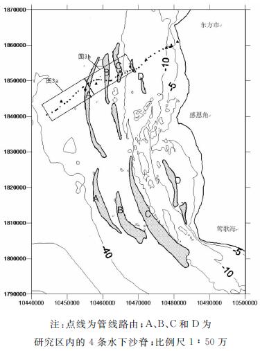
摘要: 北部湾东侧莺东潮流沙脊是整个琼西南沙脊群之一,沙脊从感恩角岸外发育最好,至东方岸外已趋缓和。根据海底特征,由海向岸分为深水平坦段、沙波沙脊段和近岸段共3个区段。沙波沙脊区段主要分布4条沙脊,这些沙脊大都呈NS或NW—SE走向,与主水流平行,呈不甚规则的长条状,长约45 km,宽度较大。脊槽高差约20~30 m,脊顶水深5~8 m,沙脊槽向不对称,向海侧缓,向陆侧陡。成因上属于全新世低海面形成的连滨沙脊,受现代浪流修蚀改造而成。这些沙脊的基础部分基本稳定,只在暴风浪或强潮流情况下表面活动性泥沙做少量迁移。2003年铺设的东方1-1气田输气管线路由经过北部湾莺东沙脊。通过对中国海洋大学东方1-1海底管线多年调查资料分析认为,本区沙波沙脊海底管线被严重掏空,已发现的130余掏空悬跨点平均长达33 m,深度最大可达1 m。管线掏空可归因于底形特征动态变化和管线改变海底水动力环境的综合作用。Abstract: The Yingdong tidal sand ridge, which occurs in the east of Beibu gulf, is a part of the Qiongxinan sand ridge system. It is well developed outside the Ganen Cornor and smmothly extends to Dongfang. The sand ridge area can be divided into three sections, the deep water flat section, the current ridge and sand wave section and the nearshore section, from the offshore to the coast. In the current ridge and sand wave section, there are four sand ridges in NS or NW-SE direction roughly parallel to the main flow. The ridges are about 45km long with a large width. The valleys between ridges are usually 20-30m in depth, while the ridge top is 5-8m below sea level. Sand valleys are asymmetrical, steep on the land side and gentle on the sea side. The sand ridges were formed in the period of low sea level in Holocene and then eroded by modern wave. The foundation of sand ridge is strong and firm. Only in case of storm wave or strong current, can the surface sediment move in a small distance. In 2003, the Dongfang 1-1 seafloor pipeline was constructed, which passed through the Yingdong tidal sand ridge. Through the analysis of the Dongfang 1-1 offshore pipeline survey data acquired by OUC after construction, it is found that there are 130 points where the pipeline are suspended. The suspended part is 33m long on average and the distance between the pipe and the sea bottom is 1m in maximum. The suspension of pipeline is caused by the changes in bedforms and/or water dynamics.
-

-
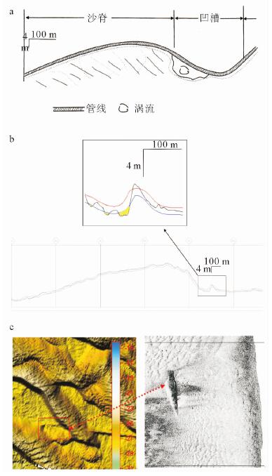
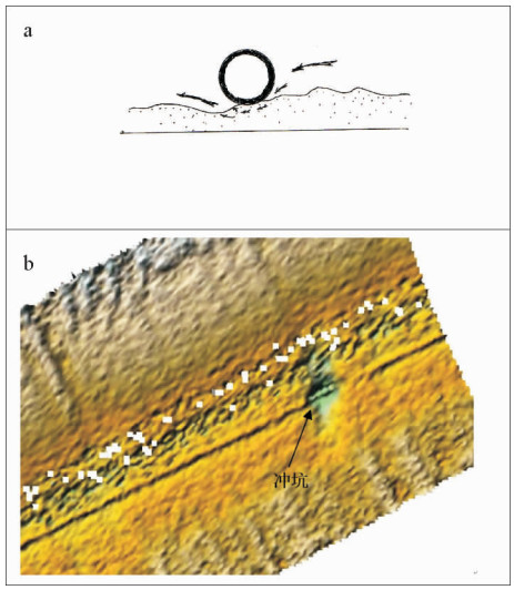
图 4 (a) 凹槽水流旁蚀沙脊引起管线掏空;(b)沙脊陡坡被底流侵蚀切割造成管线掏空(底形被动掏空),黑线为海底面,红线和蓝线为管线的上下边缘,黄色部分为掏空坑;(c)KP80.2附近的3D(左)和局部放大后的声呐图(右)
Figure 4.
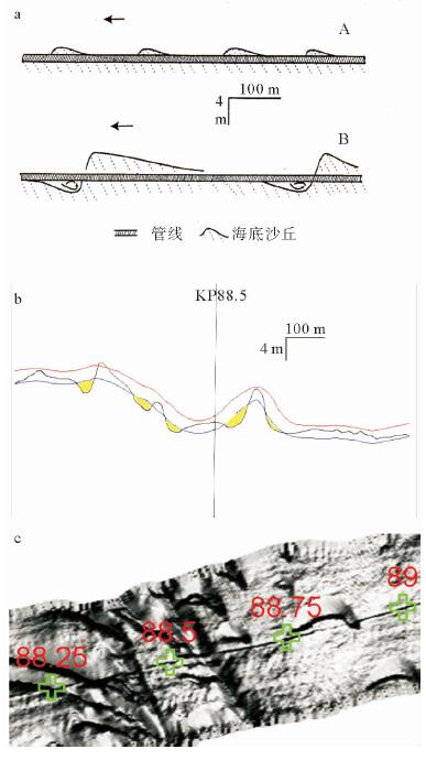
图 5 (a) 暴风浪时运动沙波尺度增大,凹槽加深引起管线掏空(A.常浪天气;B.暴风浪天气);(b)KP88.5附近的剖面图,黑线为海底面,红线和蓝线为管线的上下边缘,黄色部分为掏空坑;(c)KP88.5附近的多波束图像,管线通过大小新月形沙波区和丘间冲蚀坑
Figure 5.
-
[1] 夏东兴, 吴桑云, 刘振夏, 等.海南东方岸外海底沙波活动性研究[J].海洋科学进展, 2001, 19(1):17-24. doi: 10.3969/j.issn.1671-6647.2001.01.003
[2] 王伟伟, 范奉鑫, 李成钢, 等.海南岛西南海底沙波活动及底床冲淤变化[J].海洋地质与第四纪地质, 2007, 27(4):23-28. http://www.wanfangdata.com.cn/details/detail.do?_type=perio&id=hydzydsjdz200704004
[3] 曹立华, 徐继尚, 李广雪, 等.海南岛西部岸外沙波的高分辨率形态特征[J].海洋地质与第四纪地质, 2006, 26(4):15-22.
[4] 王琳, 吴建政, 石巍.海南乐东陆架海底沙波形态特征及活动性研究[J].海洋湖沼通报, 2007(s1):53-59. http://www.wanfangdata.com.cn/details/detail.do?_type=perio&id=hyhztb2007z1008
[5] 王文介.南海北部的潮波传播与海底沙脊和沙波发育[J].热带海洋学报, 2000, 19(1):1-7. doi: 10.3969/j.issn.1009-5470.2000.01.001
[6] 刘昭蜀.南海地质[M].北京:科学出版社, 2002.
[7] 刘乐军, 李培英, 杜军, 等.莺歌海油气资源开发区工程地质和灾害地质特征[C]//我国专属经济区和大陆架勘测研究专项学术交流会, 2004: 455-464.
[8] Allen J R L. Sedimentary structures:their character and physical basis[M]. New York:Elsevier scientific Publishing Co, 1982.
[9] Rubin D M, Hunter R E. Bedform climbing in theory and nature[J]. Sedimentology, 1982, 29(1): 121-138. doi: 10.1111/j.1365-3091.1982.tb01714.x
[10] 董志华, 曹立华, 薛荣俊.台风对北部湾南部海底地形地貌及海底管线的影响[J].海洋技术学报, 2004, 23(2):24-28. http://www.wanfangdata.com.cn/details/detail.do?_type=perio&id=hyjs200402005
[11] Chiew Y M. Mechanics of local scour around submarine pipelines[J]. Journal of Hydraulic Engineering, 1990, 116(4):515-529. doi: 10.1061/(ASCE)0733-9429(1990)116:4(515)
[12] Gao F P, Yang B, Wu Y X, et al. Steady current induced seabed scour around a vibrating pipeline[J]. Applied Ocean Research, 2006, 28(5):291-298. http://www.wanfangdata.com.cn/details/detail.do?_type=perio&id=5efa9226f520eb16a67198e937852852
[13] Sumer B M, Truelsen C, Sichmann T, et al. Onset of scour below pipelines and self-burial[J]. Coastal Engineering, 2001, 42(4):313-335. doi: 10.1016/S0378-3839(00)00066-1
[14] Aminzadeh A, Narayanan R. Erosion of sediments beneath an oscillating cylinder[J]. Maritime Engineering, 2008, 161(1):33-42. http://www.wanfangdata.com.cn/details/detail.do?_type=perio&id=bee2a7845ae060e5bdc73cfaf79aaf9f
[15] 高伟.海南东方岸外陆架底形变化特征及对海底管线状态的影响[D].青岛: 中国海洋大学, 2008.
[16] Dyer K R, Huntley D A. The origin, classification and modelling of sand banks and ridges[J]. Continental Shelf Research, 1999, 19(10):1285-1330. doi: 10.1016/S0278-4343(99)00028-X
[17] 夏东兴, 刘振夏.潮流脊的形成机制和发育条件[J].海洋学报, 1984, 6(3):361-367.
[18] 徐继尚, 李广雪, 曹立华, 等.海底管道综合探测技术及东方1-1管道不稳定因素[J].海洋地质与第四纪地质, 2009, 29(5):47-54. http://www.wanfangdata.com.cn/details/detail.do?_type=perio&id=hydzydsjdz200905006
[19] 吴建政, 胡日军, 朱龙海, 等.南海北部海底沙波研究[J].中国海洋大学学报:自然科学版, 2006, 36(6):1019-1023. doi: 10.3969/j.issn.1672-5174.2006.06.033
[20] 庄振业, 曹立华, 刘升发, 等.陆架沙丘(波)活动量级和稳定性标志研究[J].中国海洋大学学报:自然科学版, 2008, 38(6):1001-1007.
[21] 庄振业, 林振宏, 周江, 等.陆架沙丘(波)形成发育的环境条件[J].海洋地质动态, 2004, 20(4):5-10. doi: 10.3969/j.issn.1009-2722.2004.04.002
[22] 赵焕庭, 王丽荣, 袁家义.琼州海峡成因与时代[J].海洋地质与第四纪地质, 2007, 27(2):33-40. http://www.wanfangdata.com.cn/details/detail.do?_type=perio&id=hydzydsjdz200702005
-
 下载:
下载:
图(6)
计量
- 文章访问数: 1209
- PDF下载数: 53
- 施引文献: 0