

MUDDY SEDIMENTS AND COASTAL CHANGES IN AN ENCLOSED BAY IN QINGDAO, CHINA
-
摘要:
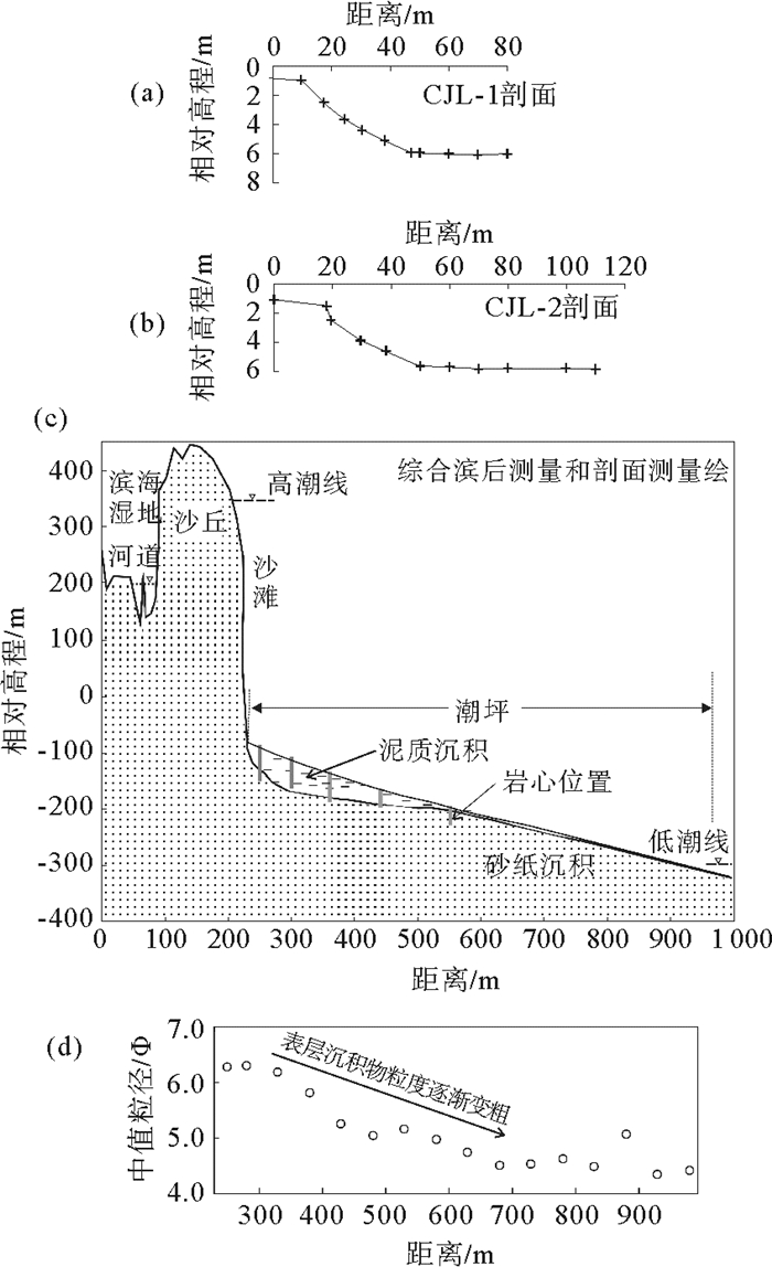
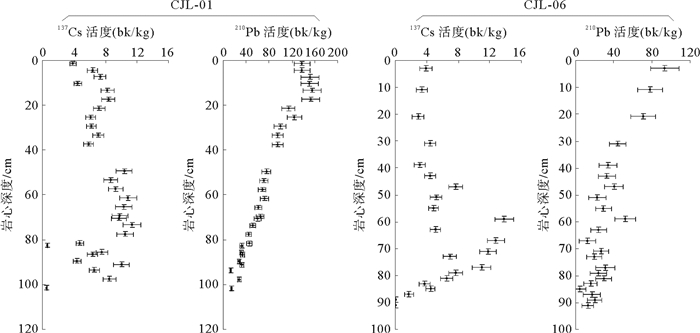
崔家潞海湾是典型的圆形海湾,海湾西侧的连续沉积了泥质潮坪和沙滩,形成独特的海岸地貌。为进一步了解这类地貌剖面特征、沉积特征、沉积速率及导致海岸变化的因素,对海滩/潮滩剖面进行测量、取样;对比了历年来的历史地图,以了解海湾湾口、入海河流、低潮线等的变化。地貌上,由陆向海的剖面揭示了小型河流、沙坝、砂质海滩和低潮带的泥质沉积。这段海岸后滨向岸有小型河流,河流输沙形成沙坝,坝后形成小型滨海湿地。光释光年代和14C显示沙坝形成于6.1 ka。利用210Pb和137Cs测年分析了泥质潮坪的沉积速率及沉积对口门变化的响应。海滩上部为中粗砂海滩,显示为低能的反射型海滩;下部则为低平的宽阔潮坪,有厚达1 m的泥质沉积,而且潮坪上没有潮沟发育,坡度小。泥质沉积在近岸处和低潮处较薄,而在中间位最厚。潮平泥质在平面上的分布也不均匀。测年和历史地图都显示,泥质沉积主要出现在1950年之后。根据137Cs, 1954年至2009年,沉积了厚达1 m的泥质,平均沉积速率在15 mm/a。测试结果还显示上部70 cm为沉积速率19.7 mm/a,大于下部20 cm沉积速率的9.0 mm/a。湾口大坝的修建可能导致淤积加快。
Abstract:Cuijialu Bay is a unique circular bay in Qingdao, China. Beach profiles, historical maps, and 210Pb/137Cs dating of sediment cores from the beaches and muddy tidal flats located along the western coast of the bay were used to study the changes that have occurred to the bay and the relationship of those changes to the construction of a harbor. The landward beach is composed of a narrow swath of coarse sand with a steep gradient. The muddy tidal flats are relatively wide with a gentle gradient and consist of muddy silts. These muddy tidal flats occur only in the middle of the western coast and are characterized by fine sediments with a depth of as much as one meter. 210Pb/137Cs data show that these muddy sediments have been present since the 1950s and have accumulated at an average rate of 15 mm/a. In a core of 1.0 meters, the upper 0.7 m of muddy sediments is deposited under a sedimentation rate greater than that of the lower 0.2 m. It suggests that muddy sediments have accumulated more rapidly during the last 35 years since 1975. That date corresponds to the construction of a dyke, which reduced the width of the bay′s mouth by 30% and has very likely increased the siltation rate in the bay. OSL ages and 14C ages show that the river mouth bar was at least formed since 6.1 ka.
-
Key words:
- low-energy beach /
- sedimentation rate /
- sand bar /
- OSL age /
- 14C age
-

-
表 1 崔家潞海岸调查简表
Table 1. Statistics of profiles
剖面号 起点位置 方向/(°) 宽度/m 调查时间 备注 CJL-1 35°45.302′N
119°54.633′E120 156 2008-9-12, 2007-10-7 测2次 CJL-1a 35°45.415′N
119°54.770′E153 500/950 2009-11-10, 2009-12-5 测、取样不同时 CJL-2 35°45.197′N
119°54.562′E145 265 2008-9-15 测沙丘  下载: 导出CSV
表 2 崔家潞2断面AMS 14C测试结果(崔2断面位置35°45.6′N,119°54.8′E)
Table 2. AMS 14C ages of profiles Cuijialu-2
送样编号 样品 测试编号 AMS 14C年龄/aBP δ13C /‰ 14C常规年龄/aBP 日历年龄/(cal aBP, 2σ) 日历年龄中值/(cal aBP) CJL-D2-06 毛蚶 GZ4060 460±25 1.3 894±25 464~547 506 CJL-D2-05 毛蚶 GZ4061 640±20 1.2 1072±20 605~871 738 CJL-D2-04 毛蚶 GZ4062 1955±20 1.6 2394±20 1969~2300 2135 CJL-D2-03 毛蚶 GZ4063 820±35 1.1 1251±35 722~1031 877 CJL-D2-02 毛蚶 GZ4064 880±20 0.8 1306±20 776~1081 929 CJL-D2-01 毛蚶 GZ4065 1370±15 1.0 1799±15 1292~1557 1425
下载: 导出CSV
表 3 崔家潞2断面和5断面光释光OSL年(误差10%)
Table 3. OSL ages of profiles Cuijialu-2 and Cuijialu-5 (error < 10%)
样品号 U/(μg/g) Th/(μg/g) K/% 年龄/ka 深度/cm 崔2样01 0.690 5.99 4.097 71 * 306 崔2样02 1.58 23.4 3.813 85 0.36 285 崔2样03 0.973 10.1 3.762 39 0.52 250 崔2样04 0.622 3.18 3.612 16 1 231 崔2样05 0.590 3.21 3.844 56 2.7 200 崔2样06 0.538 3.50 4.327 62 0.81 170 崔2样07 0.983 7.45 3.814 68 0.69 146 崔2样08 0.621 3.37 4.300 23 0.48 120 崔2样09 1.60 16.1 3.674 41 0.52 100 崔2样10 1.39 14.5 4.073 64 0.39 82 崔2样11 0.636 4.01 4.301 06 0.55 58 崔2样12 1.05 11.0 4.140 04 0.32 34 崔2样13 1.07 20.0 4.091 07 0.28 0 崔5样01 2.38 10.4 2.166 3 6.1 98 崔5样02 2.14 19.2 3.884 4 4.9 77 崔5样03 6.45 10.8 3.004 6 3.0 56 崔5样04 0.99 5.8 4.191 5 3.5 40 崔5样05 1.17 13.5 4.689 5 2.2 20 崔5样06 0.991 9.15 4.357 5 * 2 崔5样07 0.554 3 4.374 1 0 0
下载: 导出CSV
-
[1] 山东省科学技术委员会.山东省海岸带和海涂资源综合调查报告集(综合调查报告)[M].北京:中国科学技术出版社, 1990:1-793.
[2] 中国海湾志编纂委员会.中国海湾志第4分册(山东半岛北部和东部海湾)[M].北京:海洋出版社, 1991.
[3] 伊凡诺维奇M, 哈蒙R S.铀放射系的不平衡及其在环境研究中的应用[M].北京:海洋出版社, 1991:49.
[4] Palinkas C M, Nittrouer C A. Modern sediment accumulation on the Po shelf, Adriatic Sea[J]. Continental Shelf Research, 2007, 27(3/4): 489-505. http://www.wanfangdata.com.cn/details/detail.do?_type=perio&id=087a1ff98c9db819f568acedf988ccc0
[5] Jackson N L, Nordstrom K F, Eliot I, et al. Low energy sandy beaches in marine and estuarine environments: a review[J]. Geomorphology, 2002, 48(1-3): 147-162. doi: 10.1016/S0169-555X(02)00179-4
[6] 薛春汀, 周良勇.黄海西岸山东琅琊台北全新世双重障壁坝—潟湖的成因和演化[J].海洋地质与第四纪地质, 2013, 33(2):25-31. http://www.wanfangdata.com.cn/details/detail.do?_type=perio&id=hydzydsjdz201302004
-


图(6)
表(3)
计量
- 文章访问数: 834
- PDF下载数: 98
- 施引文献: 0