

THE INFLUENCE OF COASTAL MOUNTAINS ON MARINE GRAVITY DATA
-
摘要:
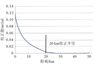
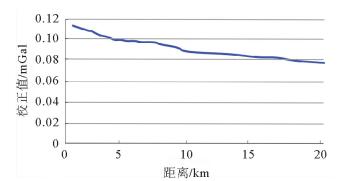
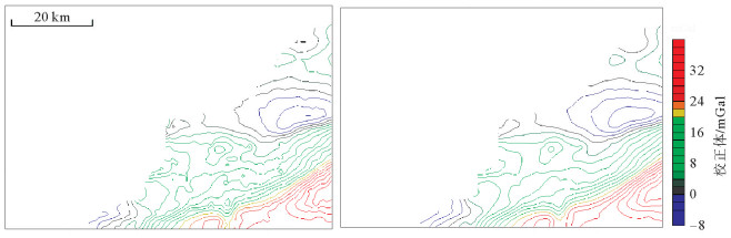
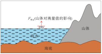
在处理近海重力数据时, 近海山体对船测重力数据的影响是不能忽略的。笔者提出一种校正近海山体对船测重力数据影响的方法, 使用点元法计算近海山体对船测重力数据的影响值, 并给出其消除方法。以位于崂山邻近海域的工区为例, 通过计算崂山的影响值可知, 测点距山体距离与影响值成反比, 最大可达0.12mGal, 当距离超过20km, 影响值忽略不计。通过上述方法, 可以得到更加准确的海洋重力数据, 从而进行更加有效的地质解释。
Abstract:Abstract: When the offshore gravity data is processed, the impact of coastal mountains on ship gravity data cannot be ignored. This paper deals with the methodology to reduce the influence of offshore mountain masses on ship measured gravity data, and the point element method is introduced to calculate the value of the influence. Then a method is given to eliminate the influence. Taking the working area off the Laoshan mountains as an example, by calculating the influence value of Laoshan, the distance between the measured point and the mountain is inversely proportional to the influence value, and the maximum is 0.12 mGal. When the distance exceeds 20 km, the influence value is neglected. Through the above method, more accurate ocean gravity data can be obtained for better geological interpretation.
-
Key words:
- marine gravity data /
- coastal mountain /
- point element method
-

-
[1] 王先超.海洋重力资料处理软件的编制及应用[D].北京:中国科学院研究生院,2007:12-35.
http://d.wanfangdata.com.cn/thesis/Y1623800 [2] 黄谟涛,刘敏,孙岚,等.海洋重力测量动态环境效应分析与补偿[J].海洋测绘,2015,35(1):1-6. doi: 10.3969/j.issn.1671-3044.2015.01.001
[3] 黄谟涛.海洋重力测线网平差[J].测绘学报,1993,22(2):103-110. doi: 10.3321/j.issn:1001-1595.1993.02.004
[4] Huang M T.Marine gravity surveying line system adjust-ment[J].Journal of Geodesy,1995,70:158-165. https://link.springer.com/article/10.1007/BF00943691
[5] Huang M T,Zhai G J,Guan Z,et al.On the compensation of systematic errors in marine gravity measurements[J].Marine Geodesy,1999,22(3):183-194. http://www.wanfangdata.com.cn/details/detail.do?_type=perio&id=10.1080/014904199273452
[6] 黄谟涛,管铮,翟国君,等.海洋重力测线网自检校平差[J].测绘学报,1999,28(2):162-171. doi: 10.3321/j.issn:1001-1595.1999.02.010
[7] 黄谟涛,翟国君,欧阳永忠,等.海洋重力测量误差补偿两步处理法[J].武汉大学学报(信息科学版),2002,27(3):251-255. http://d.old.wanfangdata.com.cn/Periodical/whchkjdxxb200203005
[8] 奚碚华,于浩,周贤高,等.海洋重力测量误差补偿技术[J].中国惯性技术学报,2011,19(1):1-5. http://d.old.wanfangdata.com.cn/Periodical/zggxjsxb201101001
[9] 吕川川,郝天珧,徐亚.海洋重力勘探中的完全布格校正[J].地球物理学进展,2010,24(2):513-521. http://d.old.wanfangdata.com.cn/Periodical/dqwlxjz200902020
[10] 陈洁,朱本铎,温宁.南海海岛海山的重磁响应特征[J].地球物理学报,2012,55(9):3152-3162. http://d.old.wanfangdata.com.cn/Periodical/dqwlxb201209033
[11] 刘展,白永良.海洋重力资料整理技术与软件实现[J].海洋地质前沿,2011,27(9):60-64. http://www.wanfangdata.com.cn/details/detail.do?_type=perio&id=hydzdt201109010
[12] 戴勤奋,杨金玉,魏合龙.海洋重力校正标准修订建议[J].地球物理学进展,2015,30(6):2633-2639. http://www.wanfangdata.com.cn/details/detail.do?_type=perio&id=dqwlxjz201506022
[13] 高金耀,张涛,谭勇华,等.不规则重磁测线网误差模型的约束最小二乘平差[J].海洋测绘,2006,26(4):6-20. doi: 10.3969/j.issn.1671-3044.2006.04.002
[14] 黄仲良.石油重、磁、电法勘探[M].东营:中国石油大学出版社,2008.
[15] 江玉乐.地球物理数据处理教程[M].北京:地质出版社,2006.
[16] 黄谟涛.海洋重力场测定及其应用[M].北京:测绘出版社,2005.
[17] 梁开龙,等.海洋重力测量与磁力测量[M].北京:测绘出版社,1996.
[18] 曾华林.重力场与重力勘探[M].北京:地质出版社,2005.
[19] 杨金玉,张训华,王修田.利用重磁计算解释南海海盆中部地壳结构特征[J].海洋地质与第四纪地质,2001,21(1):45-50. http://d.old.wanfangdata.com.cn/Periodical/hydzydsjdz200101008
[20] 尹延鸿,张训华,温珍河,等.中国东部海区及邻域区域构造图的编制方法及地质构造单元划分[J].海洋学报,2008,30(6):99-105. doi: 10.3321/j.issn:0253-4193.2008.06.012
[21] 刘光鼎.中国海区及邻域地质地球物理场系列图[M].北京:科学出版社,1992.
[22] GJB890A-2008.海洋重力测量规范[S].北京:总装备部军标出版发行部,2008.
[23] GB/T12763.8-2007.海洋地质地球物理调查规范[S].北京:中国国家标准化管理委员会,2007
-
 下载:
下载:
图(5)
计量
- 文章访问数: 618
- PDF下载数: 82
- 施引文献: 0