

-
摘要:
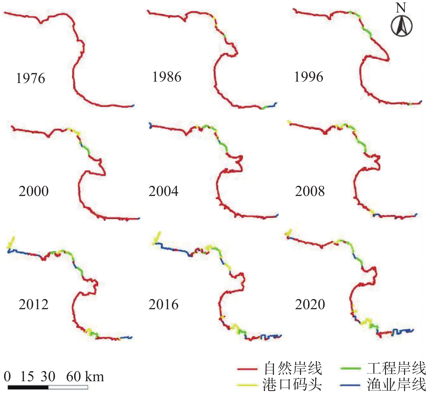
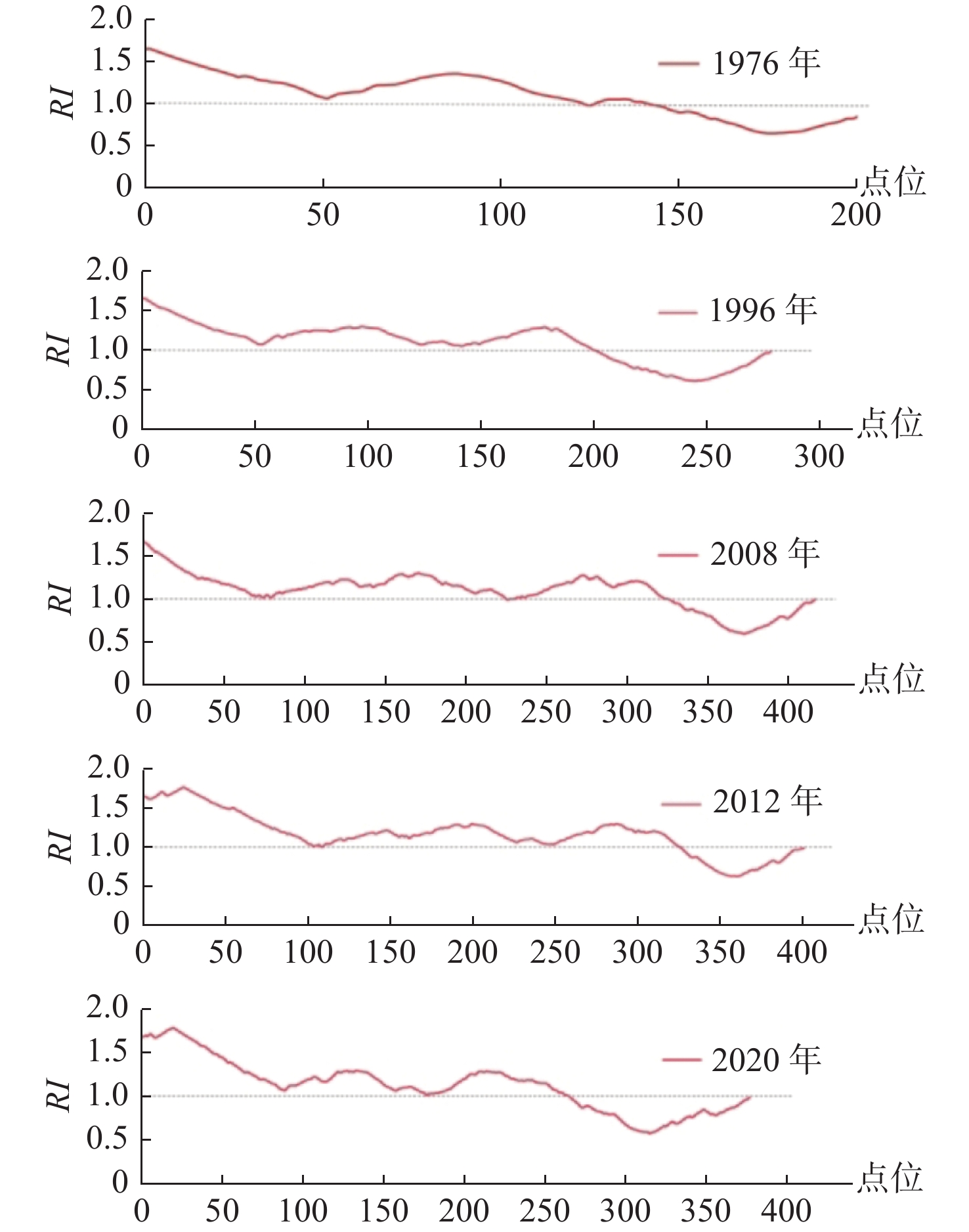
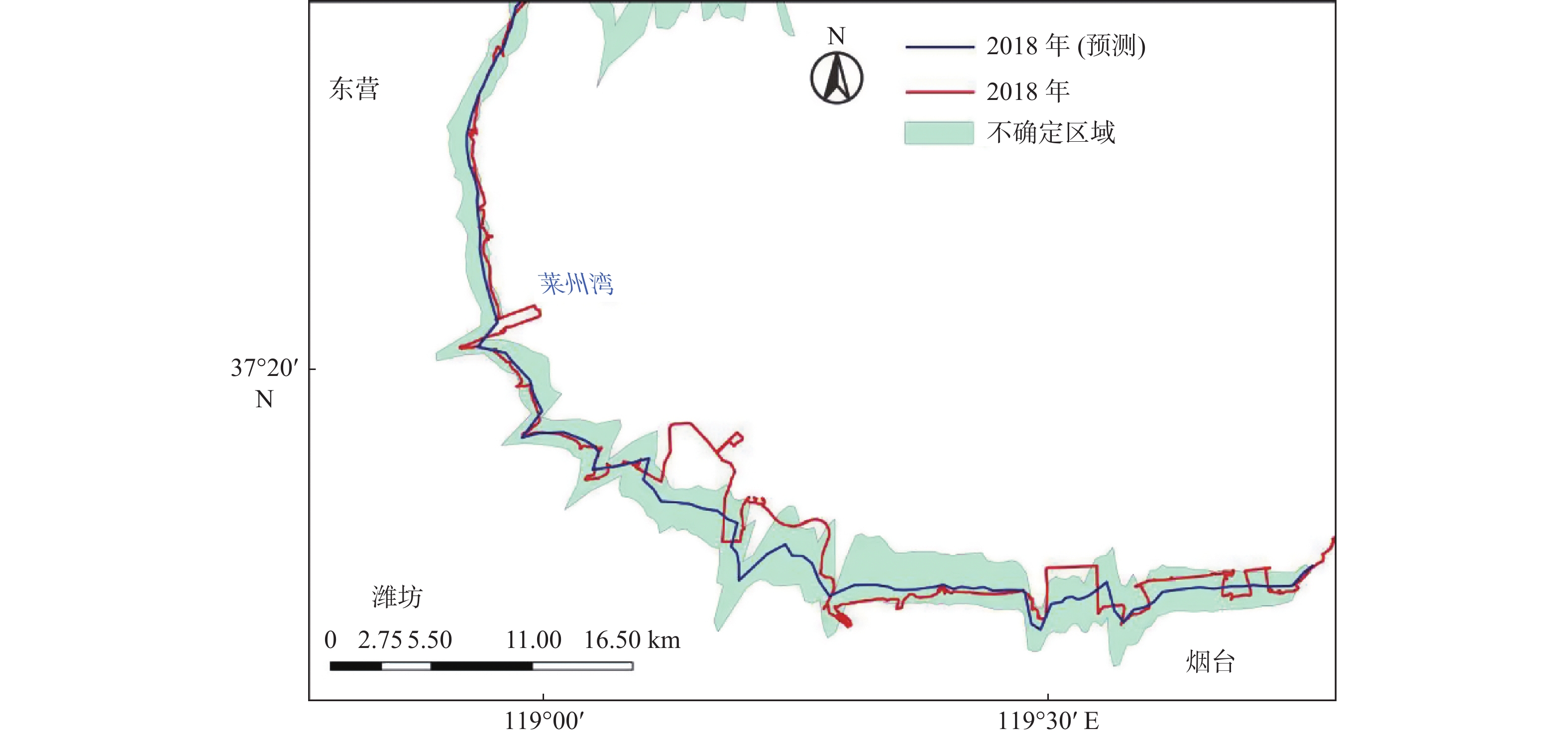
选择1976—2020年9期Landsat卫星遥感影像提取海岸线,从海岸线类型多样性指数、海岸线粗糙度、岸线变迁速率对黄河三角洲地区岸线近期演变进行定量分析,并对2030年海岸线形态进行预测,结果表明: 44年来,海岸线类型多样性指数变大,海岸线类型趋向多样化;海岸线形态粗糙,海岸线粗糙度曲线由相对平滑变为相对粗糙,形成众多“锯齿”状波动,后逐渐变平滑;河口地区岸线快速向海推进,河口两侧地区岸线则以退蚀为主;部分人工岸线向海快速推进后基本保持不变;经预测,2030年黄河三角洲河口地区,清8汊流路附近及宋春荣沟至虎头崖段岸线向海延伸,东风港至孤东油田段海岸线以侵蚀后退为主。
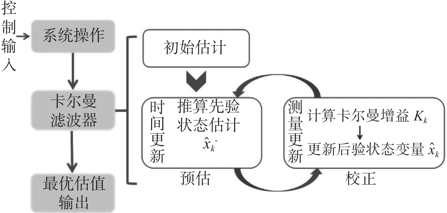
Abstract:Landsat MSS, TM, ETM+, OLI multi-temporal of 9 remote sensing data form 1976 to 2020 were used to extract the coastline of the Huanghe River deltaic regions. Quantitative analyses of the coastline in terms of the index of coastline type diversity, roughness index, the end point change rate, etc., were performed to understand the temporal and spatial evolution of the coastlines. The shoreline variation was predicted using the Kalman filter useful for the development and protection of the Huanghe River delta. Results show that in the past 44 years, the index of coastline type diversity has been increasing, and the coastline types have been diversified. The coastline was rough, the shape of the coastline roughness curve generally changed from relatively smooth to relatively tortuous, and then to little smoother than before gradually. Generally, the coastlines of the estuary area advanced rapidly seaward, while both sides of the region were eroded. The artificial coastlines remain stable. It was predicted that in 2030, the coastline near Q8 Promontory and coastal area from Songchunronggou to Hutouya would advance seaward by sedimentary accumulation, whereas the coastline from the Dongfeng Port to Gudong Oilfield would retreat landward by erosion.
-
Key words:
- Huanghe River Delta /
- coastline /
- remote sensing /
- river mouth region
-

-
表 1 遥感影像信息
Table 1. Specifications of the remote sensing imaging
序号 卫星 传感器名称 条代号/行编号 获取日期 云量 分辨率/m 1-I Landsat2 MSS 121/034 1976-12-18 — 80 1-II Landsat2 MSS 131/034 1976-12-18 — 80 2 Landsat5 TM 121/034 1986-01-28 4.94% 30 3 Landsat5 TM 121/034 1996-07-02 — 30 4 Landsat5 TM 121/034 2000-10-17 0.42% 30 5 Landsat7 ETM+ 121/034 2004-09-18 0.01% 30 6 Landsat7 ETM+ 121/034 2008-09-13 0.10% 30 7 Landsat7 ETM+ 121/034 2012-08-23 0 30 8 Landsat8 OLI_TIRS 121/034 2016-08-26 0.36% 30 9 Landsat8 OLI_TIRS 121/034 2020-07-20 3.80% 30 注:“—”为遥感数据云量信息的缺失  下载: 导出CSV
表 2 1976—2020年海岸线粗糙度统计
Table 2. Statistics of coastline roughness index from 1976 to 2020
年份 点位数 RI>1 /% Max RI Min RI 1976年 209 65.55 1.655 2 0.646 9 1986年 263 72.62 1.651 7 0.782 3 1996年 278 71.94 1.657 8 0.617 1 2000年 285 77.54 1.651 5 0.622 5 2004年 393 76.08 1.649 1 0.633 9 2008年 416 77.88 1.659 4 0.595 0 2012年 400 81.25 1.778 5 0.629 9 2016年 439 74.94 1.780 4 0.599 2 2020年 376 70.21 1.786 7 0.579 5
下载: 导出CSV
-
[1] CHU Z X,SUN X G,ZHAI S K,et al. Changing pattern of accretion/erosion of the modern Yellow River (Huanghe) subaerial delta,China:based on remote sensing images[J]. Marine Geology,2006,227(1-2):13-30. doi: 10.1016/j.margeo.2005.11.013
[2] MUSKANANFOLA M R, SUPRIHARYONO, FEBRIANTO S. Spatio-temporal analysis of shoreline change along the coast of Sayung Demak, Indonesia using Digital Shoreline Analysis System[J]. Regional Studies in Marine Science, 2020,34:101060.
[3] CHU Z X,YANG X,FENG X,et al. Temporal and spatial changes in coastline movement of the Yangtze Delta during 1974–2010[J]. Journal of Asian Earth Sciences,2013,66(8):166-174.
[4] VIVEK G,SANTONU G,et al. Monitoring of Chilika Lake mouth dynamics and quantifying rate of shoreline change using 30m multi-temporal Landsat data[J]. Data in Brief,2019,22:595-600. doi: 10.1016/j.dib.2018.12.082
[5] 韩志聪,樊彦国,李祥昌. 基于QGIS的黄河三角洲岸线演变预测系统设计与实现[J]. 测绘与空间地理信息,2016,39(6):102-104. doi: 10.3969/j.issn.1672-5867.2016.06.031
[6] 王奎峰,李念春,王薇. 黄河三角洲多年海岸线动态变迁特征及演化规律[J]. 应用海洋学学报,2018,37(3):330-338. doi: 10.3969/J.ISSN.2095-4972.2018.03.004
[7] 常军,刘高焕,刘庆生. 黄河口海岸线演变时空特征及其与黄河来水来沙关系[J]. 地理研究,2004,23(5):339-346. doi: 10.3321/j.issn:1000-0585.2004.03.007
[8] 陈小英, 刘大海. 黄河三角洲生态环境分析与评估: 海岸演变生态服务发展潜力[M]. 北京: 海洋出版社, 2012.
[9] 国家海洋局908专项办公室. 我国近海海洋综合调查与评价专项技术规程[M]. 北京: 海洋出版社, 2006.
[10] 山东省质量技术监督局. DB37/T 3588—2019. 海岸线调查技术规范[S]. 山东: 山东省标准化研究院, 2019-05-09.
[11] 毋亭. 近70年中国大陆岸线变化的时空特征分析[D]. 烟台: 中国科学院烟台海岸带研究所, 2016.
[12] 沈昆明,李安龙,蒋玉波,等. 基于数字岸线分析系统的海岸线时空变化速率分析:以海州湾为例[J]. 海洋学报(中文版),2020,42(5):117-127. doi: 10.3969/j.issn.0253-4193.2020.05.011
[13] 彭丁聪. 卡尔曼滤波的基本原理及应用[J]. 软件导刊,2009,8(11):32-34.
[14] 何金宝. 近30年海南岛岸线时空变迁与分析预测[D]. 北京: 中国地质大学(北京), 2020.
[15] CHU Z X. The dramatic changes and anthropogenic causes of erosion and deposition in the lower Yellow (Huanghe) River since 1952[J]. Geomorphology,2014,216(1):171-179.
-


图(9)
表(2)
计量
- 文章访问数: 2589
- PDF下载数: 300
- 施引文献: 0