

-
摘要:
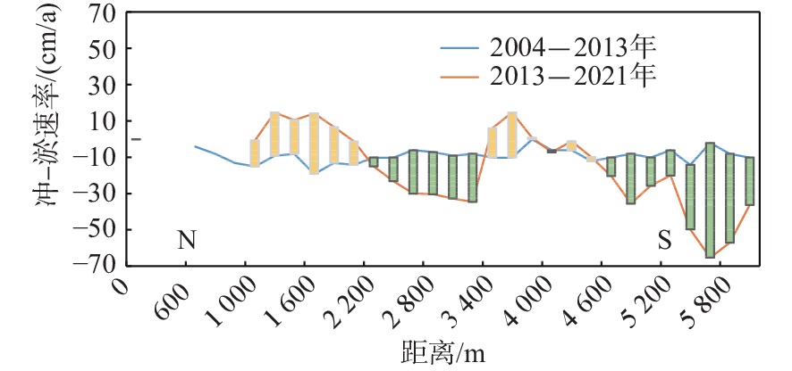
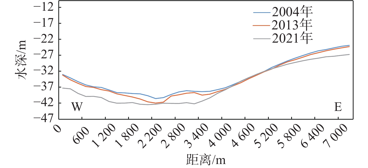
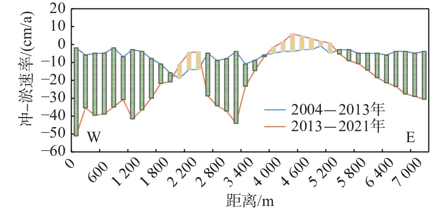
通过研究曹妃甸海区2021年实测水深和浅地层剖面资料,结合2004、2008和2013年历史资料,在区域和深度上对曹妃甸深槽海底地形进行动态对比。研究发现,深槽南侧海底冲刷作用较强烈,局部冲-淤速率最大可达−65 cm/a,这种现状有利于维持深槽水深,深槽轴线移动不明显,但35和40 m等深线均有南移趋势,最大外移距离约1 000 m。深槽地貌形成是海洋水体潮流水动力、古滦河三角洲演变和地质构造等内外营力综合作用的结果,结合浅地层剖面对比分析发现,深槽底部缺失全新世晚期海相沉积层,海底出现新的滑塌和侵蚀洼地等海洋地质灾害,对曹妃甸港带来一定的安全隐患,应加强深槽监测工作。
Abstract:Based on the bathymetric data measured in 2021 and seismic shallow profiling in Caofeidian sea area, Bohai Bay, and combined with the historical data of 2004, 2008 and 2013, the evolution in topography of Caofeidian trough was studied in terms of regional scale and water depth. Results show that the south side of the trough has been strongly scoured, and the maximum local erosion-siltation rate was −65 cm/a, which is good to maintaining the depth of the trough, and the axis movement of the trough is not obvious, except that the 35 and 40 m isobaths had a southward shifting trend, and the maximum distance of displacement was about 1000 m. The formation of the trough geomorphology is the result of the comprehensive action of internal and external forces such as tidal current hydrodynamic force, evolution of ancient Luanhe River delta and geological structure. Combined with the seismic shallow profiling, we found that the late Holocene marine sediments were missing but newer geological disaster deposits such as slumping at the bottom of the trough, forming erosional depression in the sea bottom, which may be a risk to the Caofeidian Harbor. Therefore, close monitoring to the trough shall be strengthened.
-
Key words:
- Caofeidian /
- trough /
- water depth /
- topography /
- erosion-siltation /
- Bohai Bay
-

-
[1] 褚宏宪,史慧杰,宗欣,等. 渤海湾曹妃甸深槽海区地形地貌特征及控制因素[J]. 海洋科学,2016,40(3):128-137. doi: 10.11759/hykx20140515002
[2] 褚宏宪,李强,王文辉,等. 曹妃甸浅海人工岛工程海底泥沙冲淤[J]. 海洋地质前沿,2013,29(6):37-43. doi: 10.16028/j.1009-2722.2013.06.011
[3] 陆永军,季荣耀,左利钦. 曹妃甸深水大港滩槽稳定及工程效应研究[J]. 水利水运工程学报,2009,4:33-46. doi: 10.3969/j.issn.1009-640X.2009.04.005
[4] 陆永军,左利钦,季荣耀,等. 渤海湾曹妃甸港区开发对水动力泥沙环境的影响[J]. 水科学进展,2007,18(6):793-800. doi: 10.3321/j.issn:1001-6791.2007.06.001
[5] 季荣耀,陆永军,左利钦. 渤海湾曹妃甸深槽形成机制及稳定性分析[J]. 地理学报,2011,66(3):348-355. doi: 10.11821/xb201103007
[6] 方中华. 曹妃甸甸头深槽灾害地质因素研究及稳定性分析[D]. 青岛: 中国海洋大学, 2014.
[7] 吴澎,姜俊杰. 曹妃甸港区选址研究[J]. 水运工程,2011,9:68-74. doi: 10.3969/j.issn.1002-4972.2011.09.013
[8] 陆永军,季荣耀,左利钦,等. 海湾型潮汐通道中大型深水港开发的水沙问题研究[J]. 水利学报,2007,38(12):1426-1436. doi: 10.3321/j.issn:0559-9350.2007.12.004
[9] 褚宏宪,方中华,史慧杰,等. 曹妃甸海底深槽斜坡稳定性分析与评价[J]. 海洋工程,2016,34(3):114-122. doi: 10.16483/j.issn.1005-9865.2016.03.013
[10] 褚宏宪,方中华,史慧杰,等. Newmark位移分析方法在海底斜坡地震稳定性评价中的应用[J]. 海洋地质前沿,2017,33(6):53-58. doi: 10.16028/j.1009-2722.2017.06008
[11] 褚宏宪,史慧杰,杨源,等. 利用涌浪滤波器提高水深测量精度的实践[J]. 海洋测绘,2010,30(4):51-53,62. doi: 10.3969/j.issn.1671-3044.2010.04.015
[12] 褚宏宪,周小明,史慧杰,等. 水深测量误差分析与改正[J]. 物探与化探,2011,35(3):358-363.
[13] 王艳. 渤海西北岸曹妃甸地区晚更新世末期以来古环境恢复[J]. 黄渤海海洋,2000,18(3):47-53.
[14] 李从先,陈刚,王利. 滦河废弃三角洲和砂坝:泻湖沉积体系[J]. 沉积学报,1983,1(2):60-72. doi: 10.14027/j.cnki.cjxb.1983.02.005
[15] 中国科学院海洋研究所海洋地质研究室. 渤海地质[M]. 北京: 科学出版社, 1985.
[16] 索安宁,张明慧,于永海,等. 曹妃甸围填海工程的海洋生态服务功能损失估算[J]. 海洋科学,2012,36(3):108-114.
-
 下载:
下载:


图(8)
表(1)
计量
- 文章访问数: 717
- PDF下载数: 271
- 施引文献: 0