

Quantitative analysis on the seabed terrain complexity of submarine canyons of the South China Sea continental slope
-
摘要:
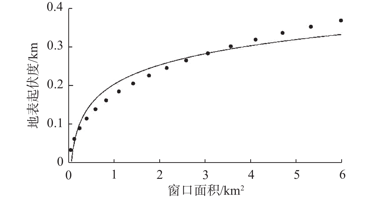
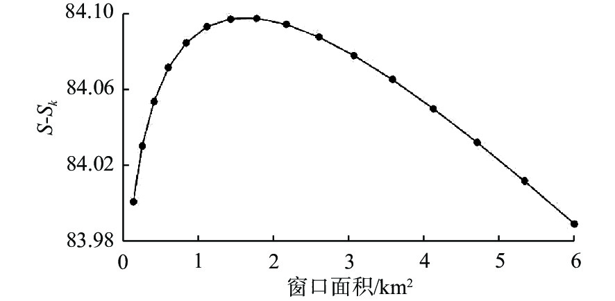
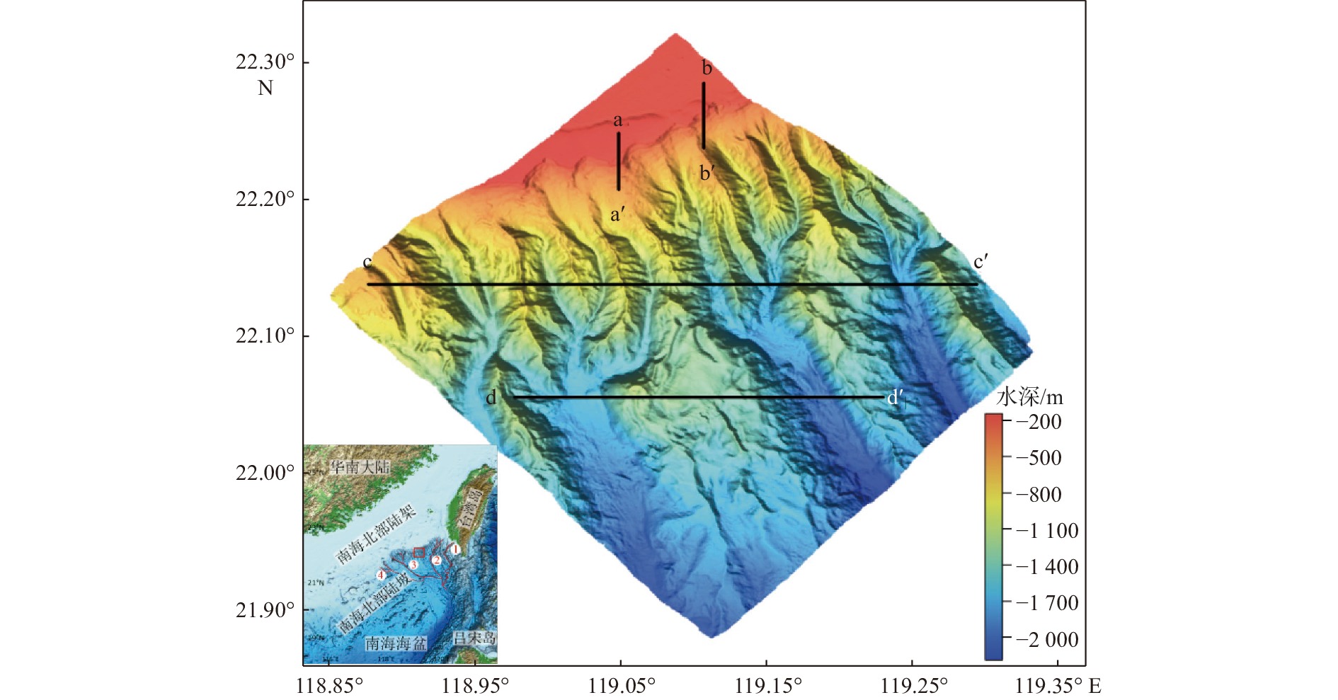
地形复杂度指数是描述地形变化程度的综合指标,本文基于南海陆坡北港隆起区的水深网格数据,采用均值变点分析法确定地形起伏度的最佳统计单元,建立计算海底地形复杂度的模型,融合研究区坡度、地形起伏度、地表切割深度和高程变异系数4种地形因子,分析研究区的地形特征和地形复杂度。结果表明,研究区地形起伏度最佳分析窗口大小为19×19网格,最佳统计窗口面积为1.768 9 km2;研究区北部及南部区域地形平坦,地形复杂程度较低,复杂度指数<2.35;中部区域存在规模不同的峡谷,地形复杂程度较高,复杂度指数平均>3.37,其中,中部偏东区域因海底峡谷最为发育,地形复杂度指数可达7.77。研究区地形复杂度的定量分析结果与海蚀作用的强弱程度呈现出较好的正相关性,这对系统开展南海海底峡谷形态特征及演化过程研究、维护海洋工程设施安全等具有重要借鉴意义。
Abstract:Terrain complexity index is a comprehensive index to the degree of terrain change. The bathymetric data of the Beigang Uplift area on the South China Sea Continental Slope were analyzed, from which terrain relief of the study area was extracted with the increasing grid window method using Matlab software. The optimal window area was determined by the mean change-point method. Four terrain factors, including slope, terrain relief, surface cutting depth, and the coefficient of elevation variation were combined to analyze the topographic characteristics of the study area. The method of calculating integrated terrain complexity based on the bathymetric data was introduced, and a computational complexity model to analyze the terrain complexity of the study area was established. Results show that the optimal analysis window size of the terrain relief of the study area was 19×19 grids and the optimal unit area was 1.768 9 km2. The northern and southern areas of the study area feature flat terrain and low terrain complexity whose complexity index is less than 2.35. Canyons of different sizes were developed in the central area with a higher level of terrain complexity whose average complexity index is more than 3.37. Among them, the central eastern region has the most developed submarine canyons, with a terrain complexity index of 7.77. The quantitative analysis results of the topographic complexity of the study area show a good positive correlation with the intensity of sea erosion, providing an important reference for the systematic study on the morphology and evolution of submarine canyons in the South China Sea and for the maintenance of the safety of marine engineering facilities.
-

-
表 1 评价因子按自然间断点分级统计表
Table 1. The statistics of the evaluation factors based on the natural discontinuity points
等级分类 低复杂度 中复杂度 高复杂度 较高复杂度 极高复杂度 分级指数 1 3 5 7 9 坡度/(°) <8.014 9 8.014 9~6.027 2 16.027 2~24.039 5 24.039 5~32.051 8 >32.051 8 面积占比/% 50.28 32.09 13.81 3.65 0.17 地形起伏度/m <132 132~259 259~386 386~513 >513 面积占比% 24.01 37.52 28.26 9.28 0.93 地表切割系数 <81 81~160 160~238 238~317 >317 面积占比% 37.28 41.96 17.04 3.42 0.30 高程变异系数 <0.062 8 0.062 8~0.123 2 0.123 2~0.183 5 0.183 5~0.243 9 >0.243 9 面积占比% 66.39 28.77 3.10 1.02 0.72  下载: 导出CSV
表 2 评价因子权重结果
Table 2. The weight table of the evaluation factors
坡度 地形起伏度 地表切割深度 高程变异系数 平均值 0.234 7 0.348 5 0.273 1 0.166 2 标准差 0.172 2 0.186 6 0.161 8 0.138 3 变异系数 0.733 9 0.535 5 0.592 7 0.832 4 归一化权重 0.272 4 0.198 7 0.220 0 0.308 9
下载: 导出CSV
表 3 综合地形复杂度结果统计
Table 3. Statistics of the comprehensive terrain complexity
等级分类 范围 面积占比/% 低复杂度 <2.35 46.69 中复杂度 2.35~3.71 31.15 高复杂度 3.71~5.06 16.52 较高复杂度 5.06~6.41 5.08 极高复杂度 >6.41 0.56
下载: 导出CSV
-
[1] 陈义兰. 基于多波束数据的东海陆坡区地形分类[D]. 青岛: 国家海洋局第一海洋研究所, 2007.
[2] 饶喆,张静远,熊宏锦. 基于二维模式复杂度的海底地形分类方法[J]. 武汉理工大学学报(交通科学与工程版),2016,40(1):77-79. doi: 10.3963/j.issn.2095-3844.2016.01.016
[3] 纪雪,周兴华,陈义兰,等. 基于BP神经网络的海底地形复杂度自动分类方法研究[J]. 海岸工程,2016,35(4):32-41. doi: 10.3969/j.issn.1002-3682.2016.04.004
[4] LOHANI P,MUKHERJEE S. Impact of terrain complexity on the turbulence drag coefficient:a case study from the Indian Himalayan region[J]. Dynamics of Atmospheres and Oceans,2021,93(4):101201.
[5] WALTER T R, ZORN E U, HARNETT C E, et al. Influence of conduit and topography complexity on spine extrusion at Shiveluch volcano, Kamchatka[J]. Communications Earth & Environment, 2022, 3(1): 169.
[6] 胡雪峰,杨燕燕,任宏磊. 基于DEM的地形地质特征对地质灾害影响研究:以沙河市为例[J]. 地下水,2022,44(2):144-145,177.
[7] 李伶俐,李江文,钟守琴,等. 基于地形复杂度的重庆市耕地“宜机化”改造适宜性评价[J]. 中国生态农业学报(中英文),2022,30(2):302-313.
[8] 李志林, 朱庆, 谢潇著. 数字高程模型(第三版)[M]. 北京: 科学出版社, 2017.
[9] 赖志坤,陈坚. 基于GEBCO的海底热液区地形复杂度分析方法研究[J]. 海洋测绘,2014,34(4):58-61. doi: 10.3969/j.issn.1671-3044.2014.04.016
[10] 何文秀,石云. 黄土丘陵沟壑区地形复杂度分析[J]. 测绘科学,2015,40(10):146-152. doi: 10.16251/j.cnki.1009-2307.2015.10.030
[11] 翟京生,张冲,李兆兴,等. 海底地貌复杂度的表示与计算[J]. 中国海洋大学学报:自然科学版,2019,49(S1):143-147.
[12] 张坤,肖燕,何振芳,等. 基于SRTM DEM的祁连山自然保护区地形特征研究[J]. 干旱区地理,2020,43(6):1559-1566.
[13] HUANG F M,YANG J B,ZHANG B,et al. Regional terrain complexity assessment based on principal component analysis and geographic information system:a case of Jiangxi Province,China[J]. ISPRS International Journal of Geo-Information,2020,9(9):539. doi: 10.3390/ijgi9090539
[14] 王冰,栾振东,张鑫,等. 台湾岛西南海域福尔摩沙海脊冷泉区地形地貌特征分析[J]. 海洋科学,2019,43(2):51-59.
[15] 王海荣,王英民,邱燕,等. 南海北部陆坡的地貌形态及其控制因素[J]. 海洋学报(中文版),2008,30(2):70-79. doi: 10.3321/j.issn:0253-4193.2008.02.009
[16] 王玉宾,吴自银,尚继宏,等. 南海东北部峡谷体系的地貌特征与发育控制因素[J]. 海洋学报(中文版),2020,42(11):62-74.
[17] 聂鑫,罗伟东,周娇. 南海东北部澎湖峡谷群沉积特征[J]. 海洋地质前沿,2017,33(8):18-23. doi: 10.16028/j.1009-2722.2017.08003
[18] 卢华兴,刘学军,汤国安. 地形复杂度的多因子综合评价方法[J]. 山地学报,2012,30(5):616-621. doi: 10.16089/j.cnki.1008-2786.2012.05.011
[19] 靳长兴. 坡度在坡面侵蚀中的作用[J] . 地理研究, 1996, 15(3): 57-63.
[20] 隋刚, 郝兵元, 彭林. 利用高程标准差表达地形起伏程度的数据分析[J]. 太原理工大学学报. 2010, 41(4): 381-384.
[21] 汤国安, 刘学军, 闾国年. 数字高程模型及地学分析的原理与方法[M]. 北京: 科学出版社, 2005.
[22] 涂汉明,刘振东. 中国地势起伏度研究[J]. 测绘学报,1991(4):311-319. doi: 10.3321/j.issn:1001-1595.1991.04.009
[23] 宁婷,崔伟,马晓勇. 基于均值变点法提取地形起伏度的影响因素分析:以黄河流域(山西段)为例[J]. 测绘通报,2022(2):159-163. doi: 10.3969/j.issn.0494-0911.2022.2.chtb202202031
[24] 朱明,张静静,马贺,等. 基于DEM和均值变点法的伏牛山区地形起伏度分析[J]. 河南大学学报(自然科学版),2020,50(1):36-43.
[25] 项静恬, 史久恩. 非线性系统中数据处理的统计方法[M]. 北京: 科学出版社, 2000.
[26] 宫厚健,李哲,刘守强. 基于AHP-变异系数法综合赋权的底板突水评价研究[J]. 煤炭技术,2018,37(7):2. doi: 10.13301/j.cnki.ct.2018.07.067
[27] ZHOU Z Y, KIZIL M, CHEN Z W, et al. A new approach for selecting best development face ventilation mode based on G1-coefficient of variation method[J]. Journal of Central South University, 2018, 25(10): 2462-2471.
[28] 李兴奇,高晓红. 综合评价结果的区分度与稳定性研究[J]. 统计与决策,2022,38(16):16-21. doi: 10.13546/j.cnki.tjyjc.2022.16.003
[29] MARINS J,AIDA M. A GIS-based modelling of vehicles rational routes:geographical information system[J]. Journal of Civil Engineering and Managent,2006,12(4):303-309. doi: 10.3846/13923730.2006.9636407
[30] GENG M H,SONG H B,GUAN Y X,et al. Characteristics and generation mechanism of gullies and mega-pockmarks in the Zhongjiannan Basin,western South China Sea[J]. Interpretation,2017,5(3):49-59. doi: 10.1190/INT-2016-0216.1
[31] MICALLEF A,MOUNTJOY J J. A topographic signature of a hydrodynamic origin for submarine gullies[J]. Geology,2011,39(2):115-118.
[32] TUBAU X,LASTRAS G,CANALS M,et al. Significance of the fine drainage pattern for submarine canyon evolution:the Foix Canyon System,Northwestern Mediterranean Sea[J]. Geomorphology,2013,184:20-37. doi: 10.1016/j.geomorph.2012.11.007
[33] 孟静娟,韩喜彬,阳凡林,等. 海底峡谷水动力系统研究[J]. 海洋地质前沿,2014,30(9):18-25. doi: 10.16028/j.1009-2722.2014.09.014
-


图(7)
表(3)
计量
- 文章访问数: 833
- PDF下载数: 108
- 施引文献: 0