

-
摘要:
瓯江口地处东海与瓯江交汇处,是浙江省温州市沿海产业带核心区,也是温州重要产业聚集区。本文在对瓯江口水文泥沙、地形地貌、沉积环境进行调查与分析的基础上,对河口动力地貌演化及水沙输运特征等进行了研究。结果表明:滩槽动力地貌体系是瓯江口地貌格局的重要组成部分,动力地貌格局是瓯江径流以及河口浪、潮、流等多种动力条件共同作用的结果;海床地形表现为北支“槽冲”、南支“滩淤”为主的分布格局特征。河口输水表现为南支落潮下泄流占优,北支大潮潮流上溯、小潮潮流下泄特征明显,同时径流、潮流共同作用下的潮流不对称现象明显。优势输水输沙作用下的瓯江南口泥沙净输运量为224~8 876 kg,瓯江北口泥沙净输运量为20~15 506 kg,底沙运动较为活跃。河口动力地貌与水沙环境是径流、潮流的相对作用、河口人类建设工程及近海环流系统共同塑造的结果。
Abstract:Oujiang Estuary is located at the confluence of the East China Sea and the Oujiang River, and it is the core area of the coastal industrial belt and an important industrial cluster in Wenzhou City, Zhejiang Province. Based on the investigation and analysis on the hydrology, sedimentology, topography, and sedimentary environment, we studied the dynamic geomorphology evolution and water-sediment transport characteristics of the estuary. Results show that the dynamic geomorphological system of shoal-channel is an important part of the geomorphological pattern of Oujiang River estuary, and the geomorphological pattern is the result of the combined action of Oujiang River runoff and the dynamic conditions of waves, tides, and currents in the estuary. The seabed topography is characterized by the distribution pattern of “channel erosion” in the northern branch and “shoal deposition” in the southern branch. The water transport in the estuary is dominated by the ebb flow in the southern branch, while the flood flow in the northern branch is evident during the spring tide and the ebb flow is evident during the neap tide. At the same time, the asymmetry of tidal currents under the combined action of runoff and tidal currents is obvious. The net sediment transport at the southern mouth of Oujiang River was between 224 and
8876 kg, while at the northern mouth, it was between 20 and15506 kg, indicating active sediment movement. The dynamic geomorphology and water-sediment environment of the estuary are the result of the relative effects of river and tidal currents, human construction projects in the estuary, and the nearshore circulation system.-
Key words:
- Oujiang River Estuary /
- sediment dynamics /
- geomorphology /
- hydrology and sediment /
- transport
-

-
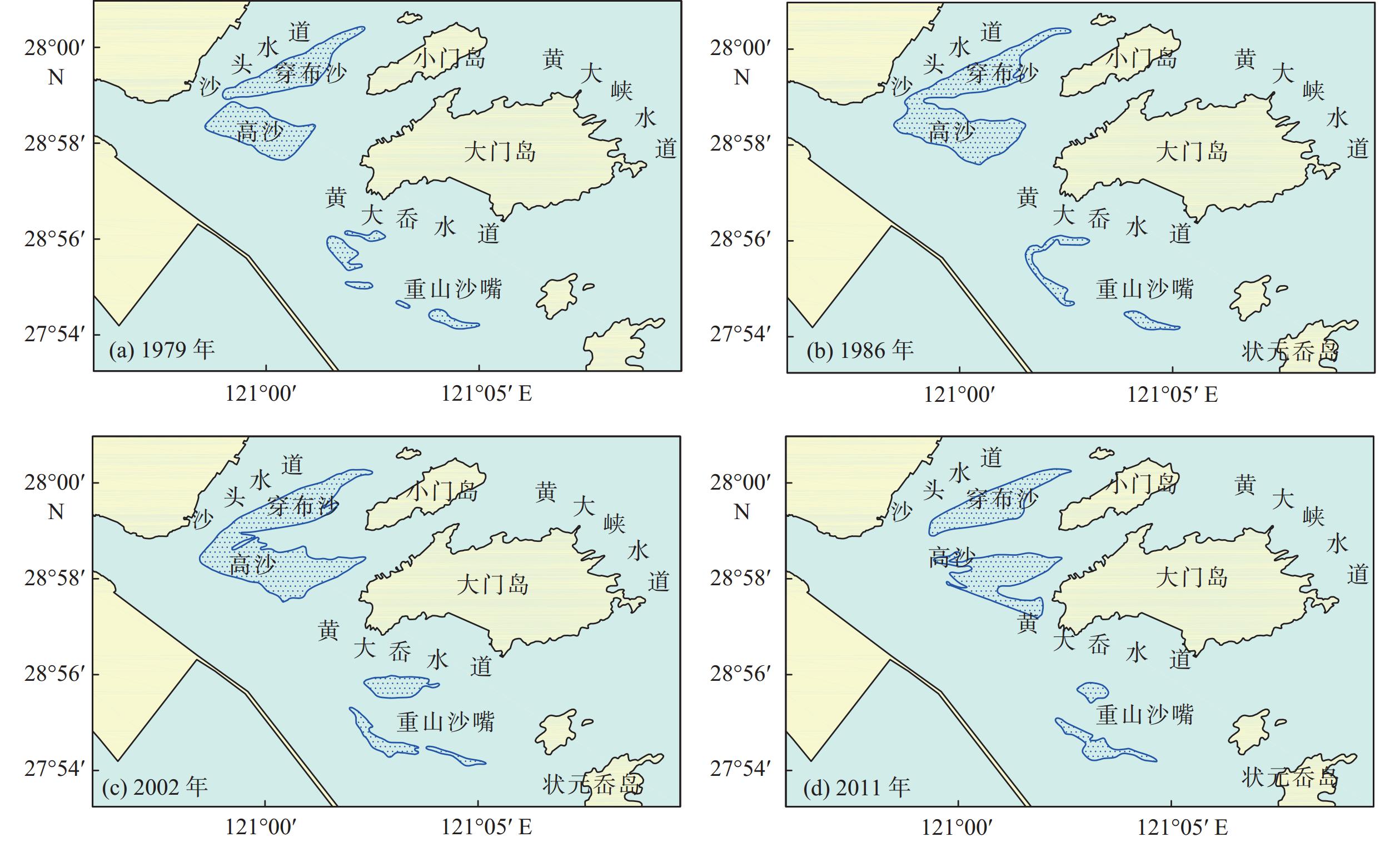
表 1 瓯江口潮流沙脊历年面积变化统计
Table 1. Statistics on the changes in the area of tidal sand ridges at the Oujiang River Estuary over the years
km2 砂体 1979年 1986年 2002年 2011年 三角沙 9.36 10.99 12.86 10.14 中沙 1.16 1.34 1.64 0.58 重山沙嘴 0.89 0.64 1.59 1.54  下载: 导出CSV
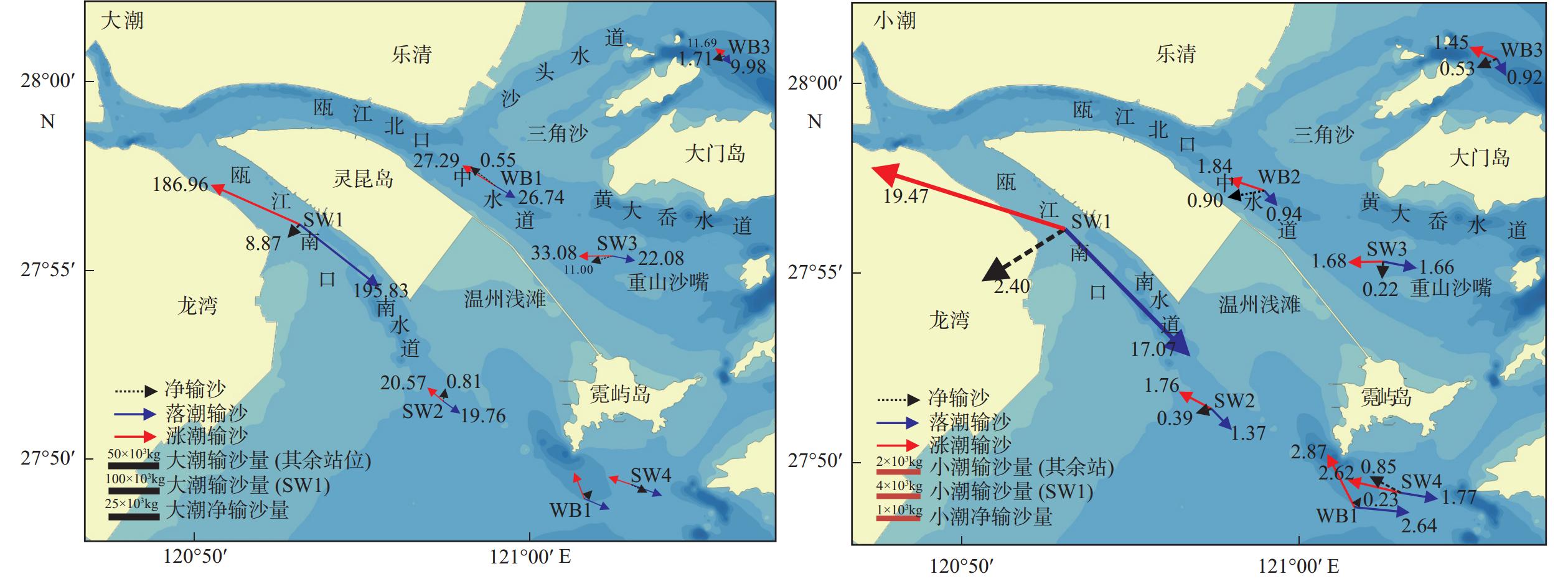
表 2 小潮、大潮期间各定点测站平均流速、流向的统计
Table 2. Statistics of the average flow velocity and direction during the neap tide and spring tide
流速/(cm/s);流向/(°) 潮汛 站位 涨落潮 表层 中层 底层 垂向平均 流速 流向 流速 流向 流速 流向 流速 流向 大潮 WB1 涨潮 50.89 318 46.23 303 61.49 303 42.37 339 落潮 55.35 141 48.87 126 63.40 133 55.47 121 WB2 涨潮 75.56 302 66.04 294 62.57 291 55.46 298 落潮 83.95 116 70.29 117 62.23 117 59.24 119 WB3 涨潮 57.82 317 65.36 314 46.39 325 54.08 315 落潮 68.44 139 48.57 139 49.52 147 57.25 136 小潮 WB1 涨潮 28.67 304 23.26 298 20.90 299 22.18 304 落潮 27.48 124 28.10 125 23.99 127 30.77 96 WB2 涨潮 43.71 310 36.76 299 29.93 296 38.62 287 落潮 49.09 124 37.60 119 24.43 128 35.51 142 WB3 涨潮 30.62 323 29.75 304 30.68 295 27.57 295 落潮 47.43 143 36.28 133 36.90 151 37.71 148
下载: 导出CSV
表 3 研究区各站位潮水输运特征
Table 3. Tidal transport characteristics of each station
输水量/m3;流向/(°) 区域 测站 潮次 落潮输水 涨潮输水 净输水 优势流指数 输水量 方向 输水量 方向 输水量 方向 南口 WB1 大潮 89 339 116 90 895 339 −1 555 46 0.496 小潮 45 231 97 38 371 336 6 860 48 0.541 SW1 大潮 82 657 129 75 221 296 7 436 213 0.524 小潮 44 769 137 41 307 288 3 462 217 0.520 SW2 大潮 68 255 127 64 417 311 3 839 35 0.514 小潮 39 063 136 38 634 296 429 216 0.503 SW4 大潮 118 303 112 99 219 286 19 084 149 0.544 小潮 52 810 100 71 725 284 −18 915 310 0.424 北口 WB2 大潮 92 446 120 97 312 356 − 4866 86 0.487 小潮 54 497 141 78 137 285 −23 640 237 0.411 WB3 大潮 56 636 93 84 691 353 −28 056 198 0.401 小潮 95 958 150 70 737 292 25 222 189 0.576 SW3 大潮 73 481 101 82 937 270 −9 456 238 0.470 小潮 47 416 102 46 081 268 1 335 210 0.507
下载: 导出CSV
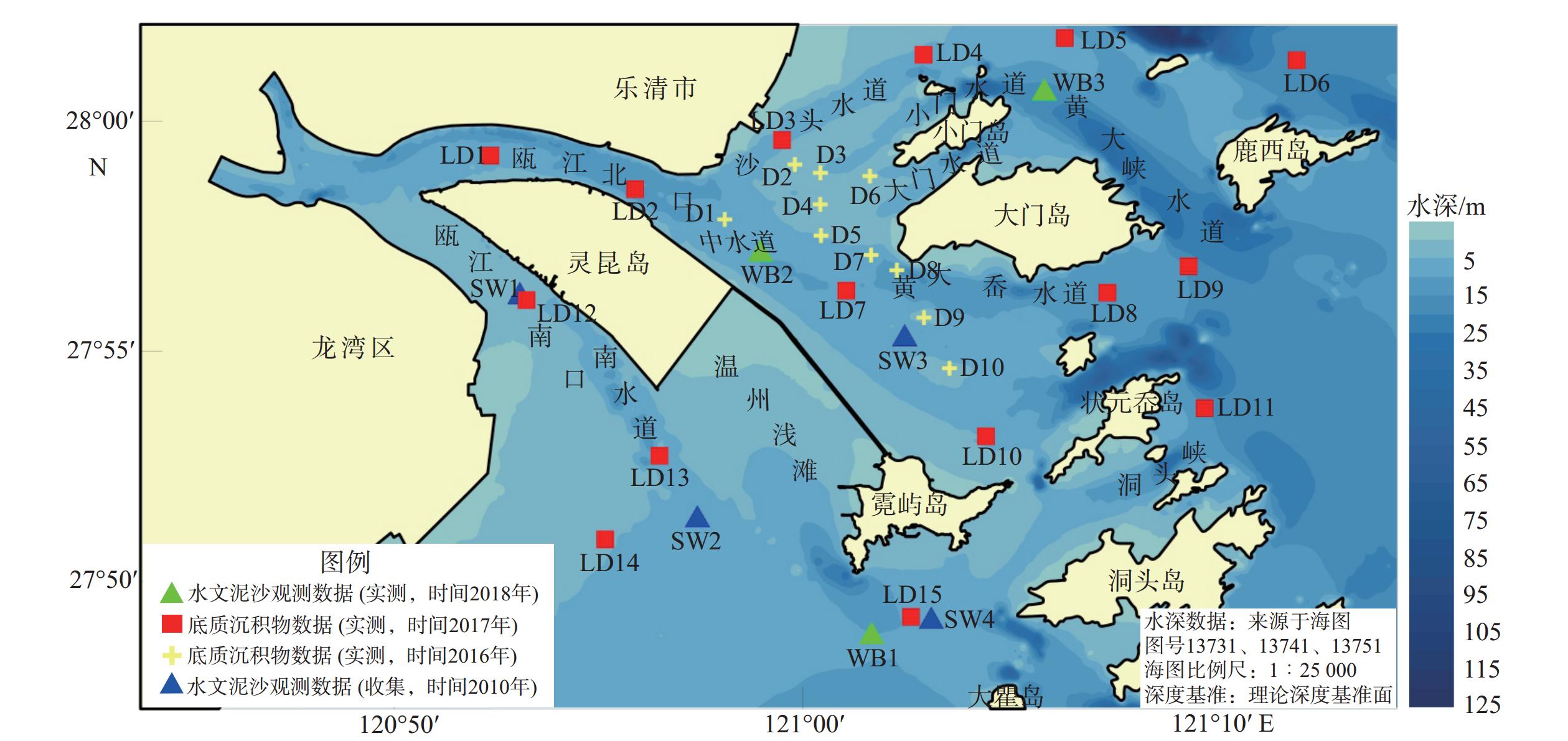
表 4 研究区各站位泥沙起动流速
Table 4. Sediment incipient velocity in each station in the study area
站位 粒径/mm 起动流速/(m/s) 张瑞瑾公式[15] 窦国仁公式[16] LD1 0.005 2.01 2.07 LD2 0.005 2.25 2.37 LD3 0.390 0.48 0.55 LD4 0.009 1.30 1.32 LD5 0.006 1.96 2.03 LD6 0.005 2.82 2.98 LD7 0.005 2.02 2.10 LD8 0.261 0.50 0.57 LD9 0.008 2.04 2.16 LD10 0.006 1.62 1.63 LD11 0.006 2.28 2.41 LD12 0.007 1.30 1.27 LD13 0.116 0.48 0.48 LD14 0.006 1.57 1.56 LD15 0.005 2.08 2.17 D1 0.349 0.47 0.51 D2 0.358 0.42 0.40 D3 0.361 0.43 0.43 D4 0.349 0.40 0.37 D5 0.351 0.43 0.43 D6 0.424 0.44 0.44 D7 0.365 0.46 0.50 D8 0.382 0.54 0.69 D9 0.303 0.41 0.38 D10 0.319 0.40 0.38 SW1 0.004 1.82 1.81 SW2 0.003 2.26 2.29 SW3 0.133 0.44 0.43 SW4 0.004 2.51 2.61
下载: 导出CSV
-
[1] 周春煦. 瓯江河口及温州浅滩冲淤演变分析[J]. 水运工程,2018(5):54-59. doi: 10.3969/j.issn.1002-4972.2018.05.011
ZHOU C X. Evolution of Oujiang Estuary and Wenzhou shoal[J]. Port and Waterway Engineering,2018(5):54-59. doi: 10.3969/j.issn.1002-4972.2018.05.011
[2] 张敏,时连强,郭俊丽,等. 浙江省沿海砾石滩地形地貌特征与发育模式[J]. 海洋地质与第四纪地质,2025,45(2):55-67.
ZHANG M,SHI L Q,GUO J L,et al. Topographic and geomorphological characteristics and development pattern of gravel beaches along the coast of Zhejiang Province[J]. Marine Geology & Quaternary Geology,2025,45(2):55-67.
[3] 曹沛奎,董永发. 浙南淤泥质海岸冲淤变化和泥沙运动[J]. 地理研究,1984,3(3):53-63.
CAO P K,DONG Y F. Variation of erosion and siltation and sedimentation of the muddy coast in the southern Zhejiang Province[J]. Geographical Research,1984,3(3):53-63.
[4] 徐海,王憬,周鸿权. 瓯江口外潮汐通道区滩槽冲淤演变分析及其调整机制的探讨[J]. 海洋学研究,2017,35(2):33-43. doi: 10.3969/j.issn.1001-909X.2017.02.004
XU H,WANG J,ZHOU H Q. Preliminary study on the mechanism of the erosion-deposition adjustment in the tidal inlet out of the Oujiang Estuary[J]. Journal of Marine Sciences,2017,35(2):33-43. doi: 10.3969/j.issn.1001-909X.2017.02.004
[5] 姚姗姗,李寿千,刘怀湘,等. 瓯江口外海区滩槽演变及主因分析[J]. 水运工程,2010(6):120-126. doi: 10.3969/j.issn.1002-4972.2010.06.026
YAO S S,LI S Q,LIU H X,et al. Experimental study on effects of waterway regulation structures on flood capacity of river[J]. Port and Waterway Engineering,2010(6):120-126. doi: 10.3969/j.issn.1002-4972.2010.06.026
[6] 单慧洁,张钊,汪一航,等. 温州鳌江近海建设工程环境影响潮汐潮流数值模拟[J]. 海洋通报,2014,33(3):250-258. doi: 10.11840/j.issn.1001-6392.2014.03.002
SHAN H J,ZHANG Z,WANG Y H,et al. The construction project environmental impact of numerical simulation of tide and tidal current in Wenzhou Aojiang offshore[J]. Marine Science Bulletin,2014,33(3):250-258. doi: 10.11840/j.issn.1001-6392.2014.03.002
[7] 蔡家新,潘国富,陈培雄. 围海工程前后瓯飞滩冲淤变化特征及动力机制分析[J]. 海洋学研究,2021,39(3):63-71.
CAI J X,PAN G F,CHEN P X. Analysis of the characteristics and dynamic mechanism of scouring and silting changes in Oufei tidal flat before and after the reclamation project[J]. Journal of Marine Sciences,2021,39(3):63-71.
[8] 莫思濠,梁泓樾,王璞,等. 强人类活动下伶仃洋河口湾沉积地貌格局演化规律[J]. 海洋地质与第四纪地质,2024,44(5):85-94.
MO S H,LIANG H Y,WANG P,et al. Evolution of sedimentology and geomorphology in the Lingding Bay under anthropogenic impact[J]. Marine Geology & Quaternary Geology,2024,44(5):85-94.
[9] 李炎,陈一宁. 基于能量耗散视角的红树林海岸沉积地貌学[J]. 海洋地质与第四纪地质,2023,43(6):25-33.
LI Y,CHEN Y N. Sedimentary geomorphology of mangrove coasts in perspective of energy dissipation[J]. Marine Geology & Quaternary Geology,2023,43(6):25-33.
[10] 季荣耀,陆永军,詹小磊等. 伶仃洋茅洲河口动力地貌演变过程[J]. 水科学进展,2019,30(6):781-788.
JI R Y,LU Y J,ZHAN X L,et al. Study on the morphodynamic evolution processes in the Maozhou estuary of the Lingding Bay[J]. Advances in Water Science,2019,30(6):781-788.
[11] 陈益,戴志军,庞文鸿,等. 北部湾大风江河口沙嘴动态变化过程[J]. 海洋地质与第四纪地质,2025,45(2):43-54.
CHEN Y,DAI Z J,PANG W H,et al. Dynamic variation of sand spit in the Dafeng River estuary,Beibu Gulf[J]. Marine Geology & Quaternary Geology,2025,45(2):43-54.
[12] 万正松,闵凤阳,张志林,等. 长江口南支分流分沙比观测与分析[J]. 南京大学学报(自然科学),2009,45(3):416-423.
WAN Z S,MIN F Y,ZHANG Z L,et al. Observations and analyses of the water and sediment discharge ratios in the southern branch,Changjiang Estuary[J]. Journal of Nanjing University (Natural Sciences),2009,45(3):416-423.
[13] 何其江,沈爱斯,刘刚,等. 西沙群岛宣德环礁水下沙洲动力地貌特征及其成因机制[J]. 海洋地质与第四纪地质,2023,43(1):1-12.
HE Q J,SHEN A S,LIU G,et al. Morphodynamic characteristics and genetic mechanism of the submarine sandbanks in Xuande Atoll,Xisha Islands[J]. Marine Geology & Quaternary Geology,2023,43(1):1-12.
[14] 赵建春,李九发,李占海,等. 长江口南汇嘴潮滩短期冲淤演变及其动力机制研究[J]. 海洋学报,2009,31(4):103-111. doi: 10.3321/j.issn:0253-4193.2009.04.012
ZHAO J C,LI J F,LI Z H,et al. Researches on characteristics and dynamic mechanism of short-term scouring and silting changes of the tidal flat on Nanhui Spit in the Changjiang Estuary in China[J]. Acta Oceanologica Sinica,2009,31(4):103-111. doi: 10.3321/j.issn:0253-4193.2009.04.012
[15] 张瑞瑾. 河流泥沙动力学[M]. 北京:中国水利水电出版社,1998:62-82.
ZHANG R J. Mechanics of River and Sediment Transport[M]. Beijing:China Water and Power Press,1998:62-82.
[16] 窦国仁. 再论泥沙起动流速[J]. 泥沙研究,1999(6):1-9. doi: 10.3321/j.issn:0468-155X.1999.06.001
DOU G R. Incipient motion of coarse and fine sediment[J]. Journal of Sediment Research,1999(6):1-9. doi: 10.3321/j.issn:0468-155X.1999.06.001
[17] 张俊勇,吴华林,陈立. 长江口北槽泥沙起动流速研究[J]. 泥沙研究,2012,1:37-40. doi: 10.3969/j.issn.0468-155X.2012.01.006
ZHANG J Y,WU H L,CHEN L. Research on incipient velocity in North Passage of Yangtze River Estuary[J]. Journal of Sediment Research,2012,1:37-40. doi: 10.3969/j.issn.0468-155X.2012.01.006
[18] 刘阿成,郭伟其,陈新玺,等. 东海北部陆坡上缘沟的地形特征和成因探讨[J]. 海洋地质与第四纪地质,2025,45(2):22-30.
LIU A C,GUO W Q,CHEN X X,et al. Topography characteristics and the origination of valleys at the upper edge of continental slope in the northern East China Sea[J]. Marine Geology & Quaternary Geology,2025,45(2):22-30.
[19] 杨家启,唐立模,黄朋. 甬江河口细颗粒泥沙起动流速研究[J]. 水利水电技术,2018,49(9):149-154.
YANG J Q,TANG L M,HUANG P. Research on the starting flow velocity of fine-grained sediment in the Yongjiang River estuary[J]. Water Resources and Hydropower Engineering,2018,49(9):149-154.
[20] 金元欢,孙志林. 中国河口盐淡水混合特征研究[J]. 地理学报,1992,47(2):165-173. doi: 10.3321/j.issn:0375-5444.1992.02.009
JIN Y H,SUN Z L. Mixing characteristics of salt water and fresh water in Chinese estuary[J]. Acta Geographica Sinica,1992,47(2):165-173. doi: 10.3321/j.issn:0375-5444.1992.02.009
[21] 毕乃双,时义睿,葛春海,等. 地形地貌变化对调水调沙期间黄河口沉积格局的影响[J]. 海洋地质与第四纪地质,2024,44(5):1-14.
BI N S,SHI Y R,GE C H,et al. Impacts of morphological evolution of the Huanghe River Mouth by artificial regulation on deltaic sedimentation[J]. Marine Geology & Quaternary Geology,2024,44(5):1-14
[22] 樊一阳,彭雲,王韫玮,等. 2017—2020年江苏中部潮滩地貌的季节和年际演化[J]. 海洋地质与第四纪地质,2023,43(6):34-44.
FAN Y Y,PENG Y,WANG Y W,et al. Seasonal and interannual evolution of geomorphology in middle Jiangsu tidal flat from 2017 to 2020[J]. Marine Geology & Quaternary Geology,2023,43(6):34-44.
[23] DUCANH N Q,TANAKA H,TAM H S,et al. Comprehensive study of the sand spit evolution at tidal inlets in the central coast of Vietnam[J]. Journal of Marine Science and Engineering,2020,8(9):722. doi: 10.3390/jmse8090722
[24] 贺松林. 瓯江河口内外堆积带的形成分析[J]. 海洋学报,1983,5(5):612-622.
HE S L. Analysis of the formation of accumulation zones inside and outside the Oujiang Estuary[J]. Acta Oceanologica Sinica,1983,5(5):612-622.
[25] 宋乐,夏小明,刘毅飞. 瓯江河口入海水沙通量的变化规律[J]. 泥沙研究,2012,1:46-52. doi: 10.3969/j.issn.0468-155X.2012.01.008
SONG L,XIA X M,LIU Y F. Variations in water and sediment fluxes from Oujiang River to Estuary[J]. Journal of Sediment Research,2012,1:46-52. doi: 10.3969/j.issn.0468-155X.2012.01.008
[26] 王翠,郭晓峰,方婧. 闽浙沿岸流扩展范围的季节特征及其对典型海湾的影响[J]. 应用海洋学学报,2018,37(1):1-8. doi: 10.3969/J.ISSN.2095-4972.2018.01.001
WANG C,GUO X F,FANG J. Characteristics of seasonal spatial expansion of Fujian and Zhejiang coastal current and their bay effects[J]. Journal of Applied Oceanography,2018,37(1):1-8. doi: 10.3969/J.ISSN.2095-4972.2018.01.001
[27] 庄佳铨,罗科,彭雲,等. 基于无人机SfM摄影测量的潮间带牡蛎礁地貌调查[J]. 海洋地质与第四纪地质,2023,43(6):45-54.
ZHUANG J Q,LUO K,PENG Y,et al. Geomorphological survey of intertidal oyster reefs based on UAV Structure-from-Motion photogrammetry[J]. Marine Geology & Quaternary Geology,2023,43(6):45-54.
[28] 陈斌,高飞,刘健. 夏季浙江沿岸陆架区泥沙输运机制[J]. 海洋学报,2017,39(3):96-105. doi: 10.3969/j.issn.0253-4193.2017.03.009
CHEN B,GAO F,LIU J. Sediment transport mechanism in the Zhejiang inner continental shelf in summer[J]. Acta Oceanologica Sinica,2017,39(3):96-105. doi: 10.3969/j.issn.0253-4193.2017.03.009
[29] 陈奇,张阳,唐雯雯,等. 低空无人机平台应用于海滩地形监测的初步研究[J]. 海洋地质与第四纪地质,2023,43(6):55-68.
CHEN Q,ZHANG Y,TANG W W,et al. Application of low-altitude airspace UAVs in beach terrain monitoring[J]. Marine Geology & Quaternary Geology,2023,43(6):55-68.
[30] PRADHAN U,MISHRA P,MOHANTY P K,et al. Formation,growth and variability of sand spit at Rushikulya River Mouth,South Odisha Coast,India[J]. Procedia Engineering,2015,116:963-970. doi: 10.1016/j.proeng.2015.08.387
-


图(6)
表(4)
计量
- 文章访问数: 20
- PDF下载数: 4
- 施引文献: 0