

Co-evolution mechanism of groundwater and wetland ecosystem in a typical inland watershed in northwest China
-
摘要:
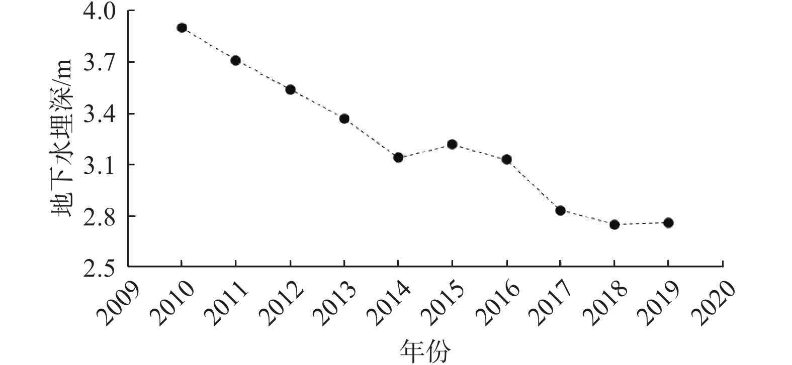
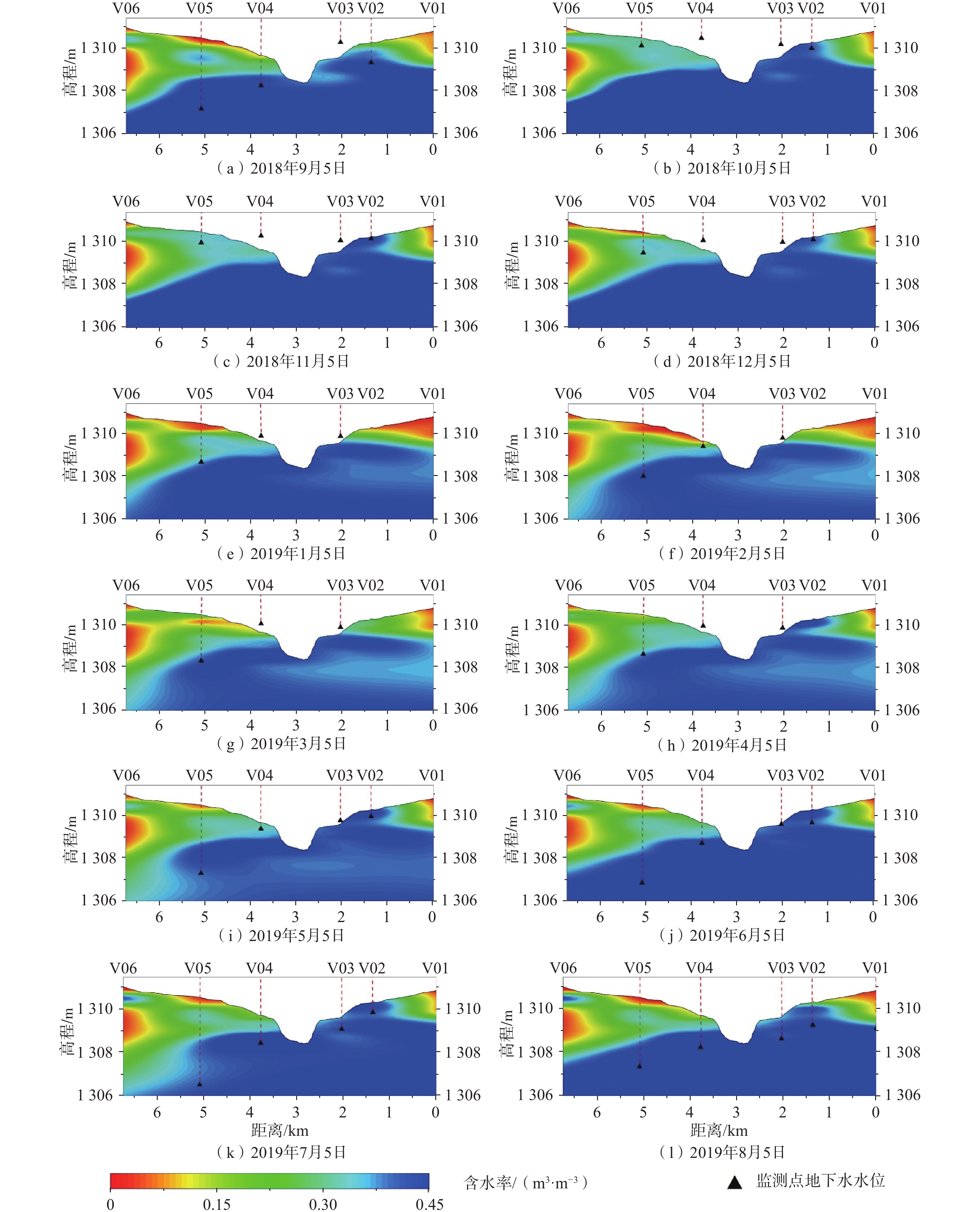
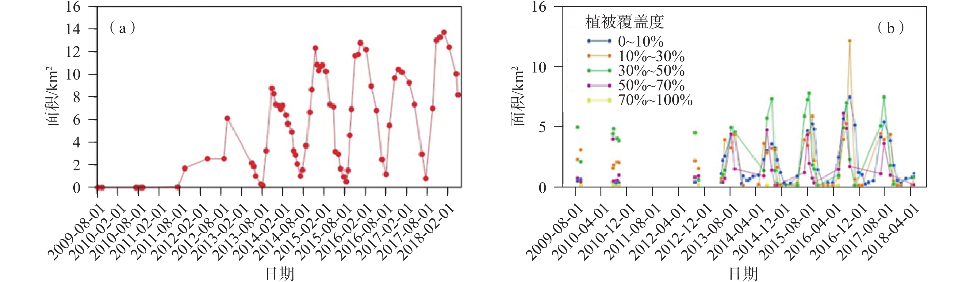
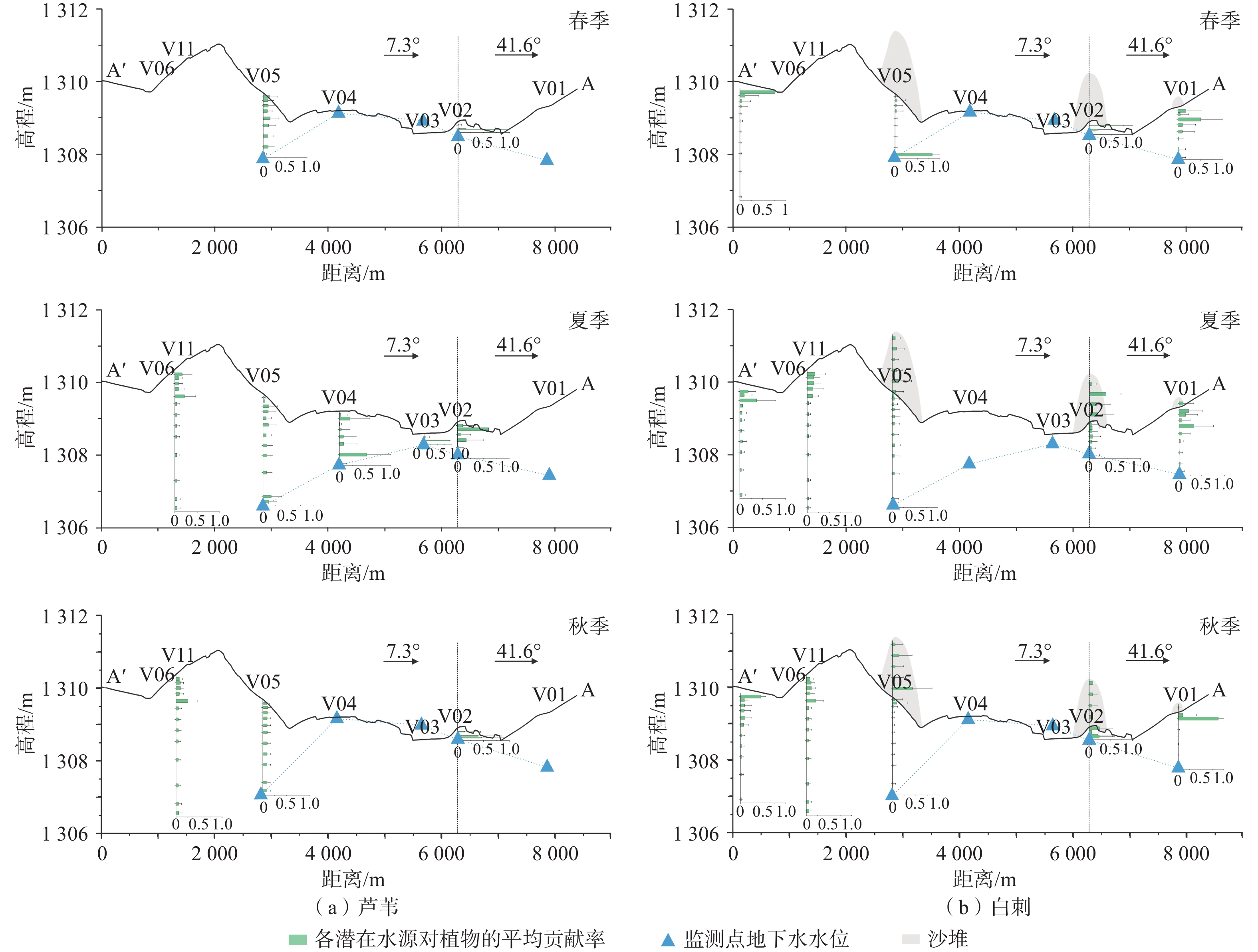
以生态输水为代表的湿地修复工程在西北内陆流域得到了广泛应用,生态输水情形下地下水与湿地植被的交互作用决定着湿地生态系统的演化过程。以西北典型内陆流域——石羊河流域青土湖湿地为研究区,基于地下水-湿地生态系统多要素一体化动态监测网络,结合稳定同位素和卫星遥感技术手段,分析生态输水情形下的地下水动态变化与湿地植被恢复情况,从水文地质角度揭示地下水与湿地生态系统的协同演化机制。结果显示:夏季末和秋季生态输水时,湖水补给地下水且土壤含水率增大,最大土壤含水率可达0.45 m3/m3;冬季湿地湖面和表层土壤冻结,湖水对地下水补给量减少,春季冻土和湖面消融导致地下水略有回升,同时增大土壤含水率;夏季在下次生态输水前湖面面积最小(湖面面积最小约为1 km2,地下水水位最大埋深为3.6 m),部分区域地下水补给湖水,此时表层土壤含水率也最低(最小土壤含水率为 0.01 m3/m3);夏季末和秋季生态输水通过将生态水储存在地下水和土壤中进而作用于次年的植被恢复与生长,增大生态输水所形成的湖面面积有助于增加湿地植被覆盖度(相关系数均值为0.655);湿地地表水-土壤-地下水相互作用所形成的土壤水环境是影响湿地植被类型、根系分布和水分利用策略的主要原因,其中地下水埋深是关键性因素,地下水埋深增大导致植被类型增多、根系分布深度加大、倾向于利用深层土壤水。研究成果可为西北内陆流域湿地生态系统恢复和水资源高效利用提供科学依据。
Abstract:Wetland restoration projects represented by ecological water conveyance have been widely used in the inland watersheds in northwest China. The interaction between groundwater and wetland vegetation under the ecological water conveyance determines the evolution of wetland ecosystems. In this study, the Qingtu Lake Wetland of the Shiyang River Basin in northwest China is taken as the research area, and the groundwater dynamic change and wetland vegetation restoration under the condition of the ecological water conveyance are analyzed based on a multi-element integrated monitoring network of groundwater-wetland ecosystem, combining with technologies of stable isotopes and satellite remote sensing. The purpose of this work is to reveal the co-evolution mechanism of groundwater and wetland ecosystems from the perspective of hydrogeology. The results show that the lake water recharges groundwater and the soil moisture increases during the ecological water delivery in late summer and autumn (the maximum soil moisture of observation sites is 0.45 m3/m3). In winter, this recharge decreases with the freezing of lake and surface soil. The thawing of frozen soil and lake in spring leads to a slight recovery of groundwater and an increase in soil moisture. In summer, the lake surface and the groundwater level are the smallest before the next ecological water delivery (the minimum surface area is about 1 km2, and the maximum groundwater depth of observation sites is 3.6 m). Meanwhile, the surface soil moisture is also the lowest (the minimum soil moisture of observation sites is 0.01 m3/m3), and the groundwater recharges the lake in some areas. The ecological water conveyed in late summer and autumn can act on vegetation recovery and growth in the following year by storing the water in groundwater and soil. Increasing the lake surface area formed by ecological water is helpful in upgrading vegetation coverage (the average correlation coefficient is 0.655). The soil water environment formed by the interaction of surface water-soil-groundwater is the main factor affecting vegetation types, root distribution and water use strategy. It is mainly controlled by the groundwater depth. With the increasing groundwater depth, the vegetation types and root depths increase, and the vegetations tend to use deep soil water. The research results can provide a scientific basis for the restoration of wetland ecosystems and efficient use of water resources in the northwestern inland basins.
-

-
表 1 2010—2019年红崖山水库向青土湖湿地放水时间
Table 1. The release time of water from Hongyashan Reservoir to Qingtu Lake Wetland from 2010 to 2019
输水开始时间 输水结束时间 输水开始时间 输水结束时间 2010-09-01 2010-10-20 2015-08-17 2015-11-05 2011-09-02 2011-10-24 2016-07-30 2016-11-03 2012-07-31 2012-11-25 2017-08-01 2017-11-21 2013-08-02 2013-11-05 2018-08-06 2018-11-06 2014-06-09 2014-11-04 2019-08-01 2019-10-30  下载: 导出CSV
表 2 当年生态输水形成的最大湖面面积与次年7月各植被覆盖度对应面积的相关性
Table 2. Correlations between the largest lake surface area formed by ecological water transport in the current year and the area of vegetation coverage at different levels in July of the following year
FVC 0~10% 10%~30% 30%~50% 50%~70% 70%~100% 相关系数 0.853 0.788 0.982 0.437 0.217
下载: 导出CSV
-
[1] 周茂箐,春喜,梁文军,等. 中国干旱区湿地变化与修复研究综述[J]. 内蒙古农业大学学报(自然科学版),2018,39(2):94 − 100. [ZHOU Maoqing, CHUN Xi,LIANG Wenjun,et al. A review on wetland changing and restoration research of China arid-region[J]. Journal of Inner Mongolia Agricultural University (Natural Science Edition),2018,39(2):94 − 100. (in Chinese with English abstract)
[2] 孙自永,王俊友,葛孟琰,等. 基于水稳定同位素的地下水型陆地植被识别:研究进展、面临挑战及未来研究展望[J]. 地质科技通报,2020,39(1):11 − 20. [SUN Ziyong,WANG Junyou,GE Mengyan,et al. Isotopic approaches to identify groundwater dependent terrestrial vegetation:Progress,challenges,and prospects for future research[J]. Bulletin of Geological Science and Technology,2020,39(1):11 − 20. (in Chinese with English abstract)
[3] HOSE G C,BAILEY J,STUMPP C,et al. Groundwater depth and topography correlate with vegetation structure of an upland peat swamp, Budderoo Plateau, NSW, Australia[J]. Ecohydrology,2014,7(5):1392 − 1402.
[4] MATA-GONZÁLEZ R,MARTIN D W,MCLENDON T,et al. Invasive plants and plant diversity as affected by groundwater depth and microtopography in the Great Basin[J]. Ecohydrology,2012,5(5):648 − 655. doi: 10.1002/eco.252
[5] 郑丹,李卫红,陈亚鹏,等. 干旱区地下水与天然植被关系研究综述[J]. 资源科学,2005(4):160 − 167. [ZHENG Dan,LI Weihong,CHEN Yapeng,et al. Relations between groundwater and natural vegetation in the arid zone[J]. Resources Science,2005(4):160 − 167. (in Chinese with English abstract) doi: 10.3321/j.issn:1007-7588.2005.04.027
[6] HAO X, LI W. Impacts of ecological water conveyance on groundwater dynamics and vegetation recovery in the lower reaches of the Tarim River in northwest China[J]. Environmental Monitoring and Assessment,2014,186(11):7605 − 7616. doi: 10.1007/s10661-014-3952-x
[7] FAN Y. Groundwater in the earth’s critical zone:Relevance to large-scale patterns and processes[J]. Water Resources Research,2015,51(5):3052 − 3069. doi: 10.1002/2015WR017037
[8] FAN Y,MIGUEZ-MACHO G,JOBBÁGY E G,et al. Hydrologic regulation of plant rooting depth[J]. Proceedings of the National Academy of Sciences,2017,114(40):10572 − 10577. doi: 10.1073/pnas.1712381114
[9] SUN Z,LONG X,MA R. Water uptake by saltcedar (Tamarix ramosissima) in a desert riparian forest:Responses to intra-annual water table fluctuation[J]. Hydrological Processes,2016,30(9):1388 − 1402. doi: 10.1002/hyp.10688
[10] FRIEDMAN J M,AUBLE G T,SHAFROTH P B,et al. Dominance of non-native riparian trees in western USA[J]. Biological Invasions,2005,7(4):747 − 751. doi: 10.1007/s10530-004-5849-z
[11] WEST A G,GOLDSMITH G R,MATIMATI I,et al. Spectral analysis software improves confidence in plant and soil water stable isotope analyses performed by isotope ratio infrared spectroscopy (IRIS)[J]. Rapid Communications in Mass Spectrometry,2011,25(16):2268 − 2274. doi: 10.1002/rcm.5126
[12] NIPPERT J B,BUTLER J J,KLUITENBERG G J,et al. Patterns of Tamarix water use during a record drought[J]. Oecologia,2010,162(2):283 − 292. doi: 10.1007/s00442-009-1455-1
[13] 姜生秀,安富博,马剑平,等. 石羊河下游青土湖白刺灌丛水分来源及其对生态输水的响应[J]. 干旱区资源与环境,2019,33(9):176 − 182. [JIANG Shengxiu,AN Fubo,MA Jianping,et al. Water sources of Nitraria tangutorum nebkhas and tis response to ecological water transfer in Qingtu lake in lower reaches of Shiyang river[J]. Journal of Arid Land Resources and Environment,2019,33(9):176 − 182. (in Chinese with English abstract)
[14] ORELLANA F,VERMA P,LOHEIDE I S P,et al. Monitoring and modeling water-vegetation interactions in groundwater-dependent ecosystems[J]. Reviews of Geophysics,2012,50(3):RG3003.
[15] WU X,MA T,WANG Y. Surface water and groundwater interactions in wetlands[J]. Journal of Earth Science,2020,31(5):1016 − 1028. doi: 10.1007/s12583-020-1333-7
[16] 王文科,宫程程,张在勇,等. 旱区地下水文与生态效应研究现状与展望[J]. 地球科学进展,2018,33(7):702 − 718. [WANG Wenke,GONG Chengcheng,ZHANG Zaiyong,et al. Research status and prospect of the subsurface hydrology and ecological effect in arid regions[J]. Advances in Earth Science,2018,33(7):702 − 718. (in Chinese with English abstract) doi: 10.11867/j.issn.1001-8166.2018.07.0702
[17] 徐涵秋. 利用改进的归一化差异水体指数(MNDWI)提取水体信息的研究[J]. 遥感学报,2005,9(5):589 − 595. [XU Hanqiu. A study on information extraction of water body with the Modified Normalized Difference Water Index (MNDWI)[J]. Journal of Remote Sensing,2005,9(5):589 − 595. (in Chinese with English abstract)
[18] TUCKER C J. Red and photographic infrared linear combinations for monitoring vegetation[J]. Remote Sensing of Environment,1979,8(2):127 − 150. doi: 10.1016/0034-4257(79)90013-0
[19] JIA K,LIANG S,GU X,et al. Fractional vegetation cover estimation algorithm for chinese GF-1 wide field view data[J]. Remote Sensing of Environment,2016,177:184 − 191. doi: 10.1016/j.rse.2016.02.019
[20] MOORE J W,SEMMENS B X. Incorporating uncertainty and prior information into stable isotope mixing models[J]. Ecology Letters,2008,11(5):470 − 480. doi: 10.1111/j.1461-0248.2008.01163.x
-


图(8)
表(2)
计量
- 文章访问数: 1684
- PDF下载数: 99
- 施引文献: 0