

An analysis on the destruction mode of Wuxia scissors peak down the shore slope in the Three-Gorges Reservoir area
-
摘要:
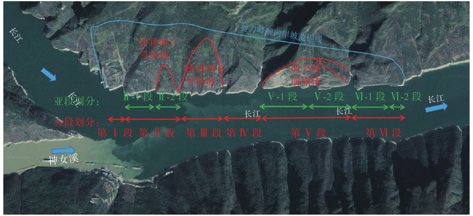
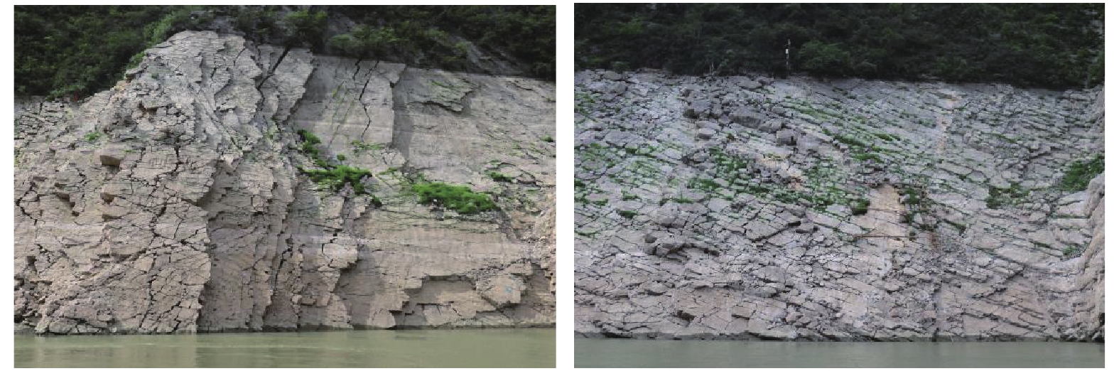
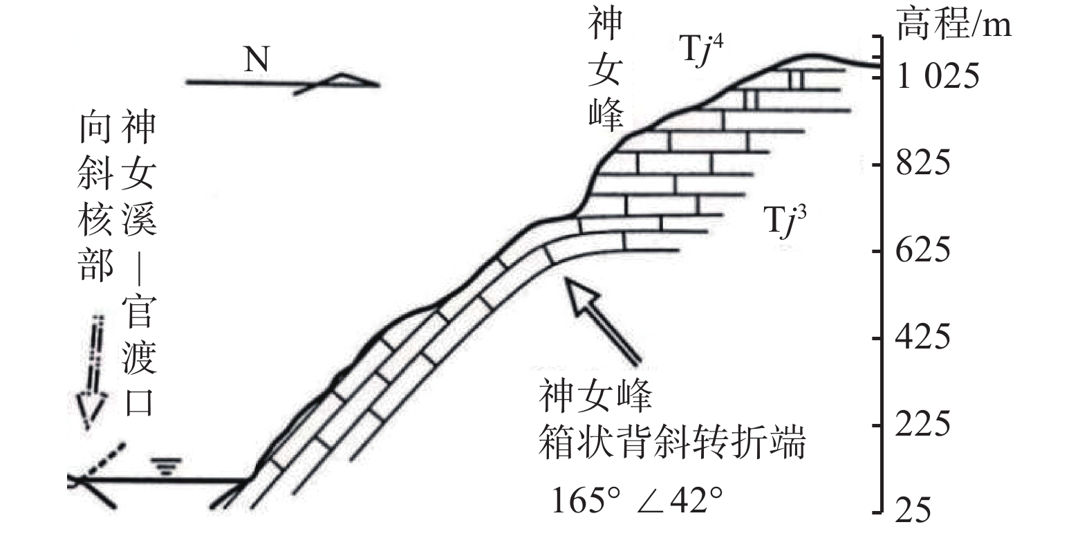
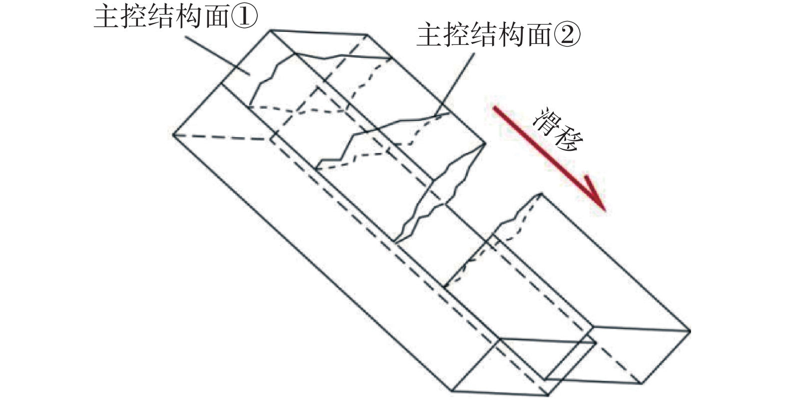
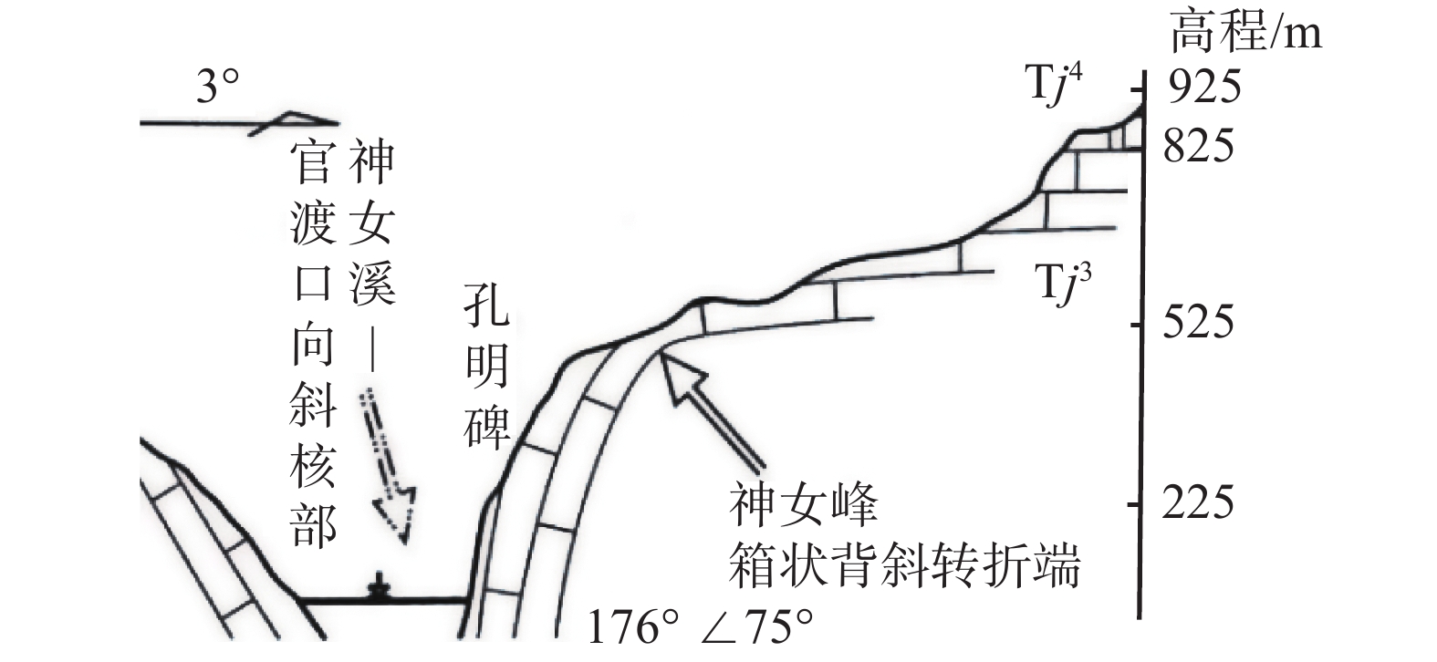
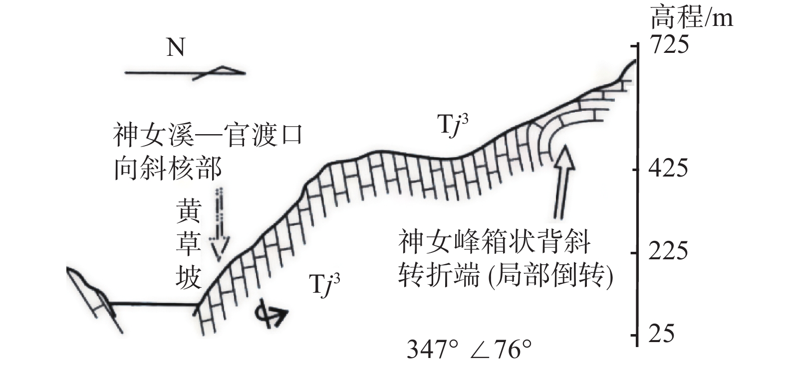
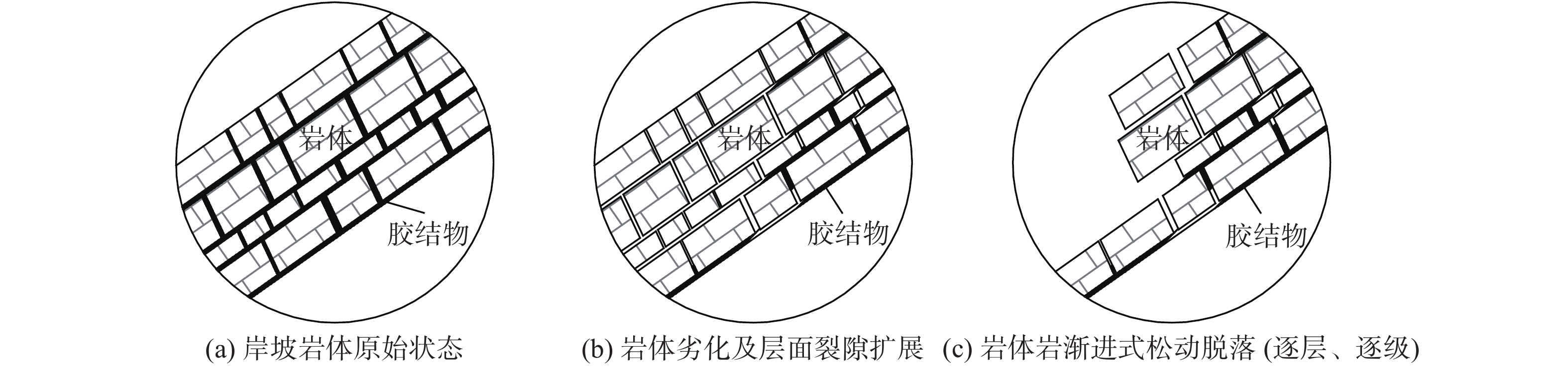
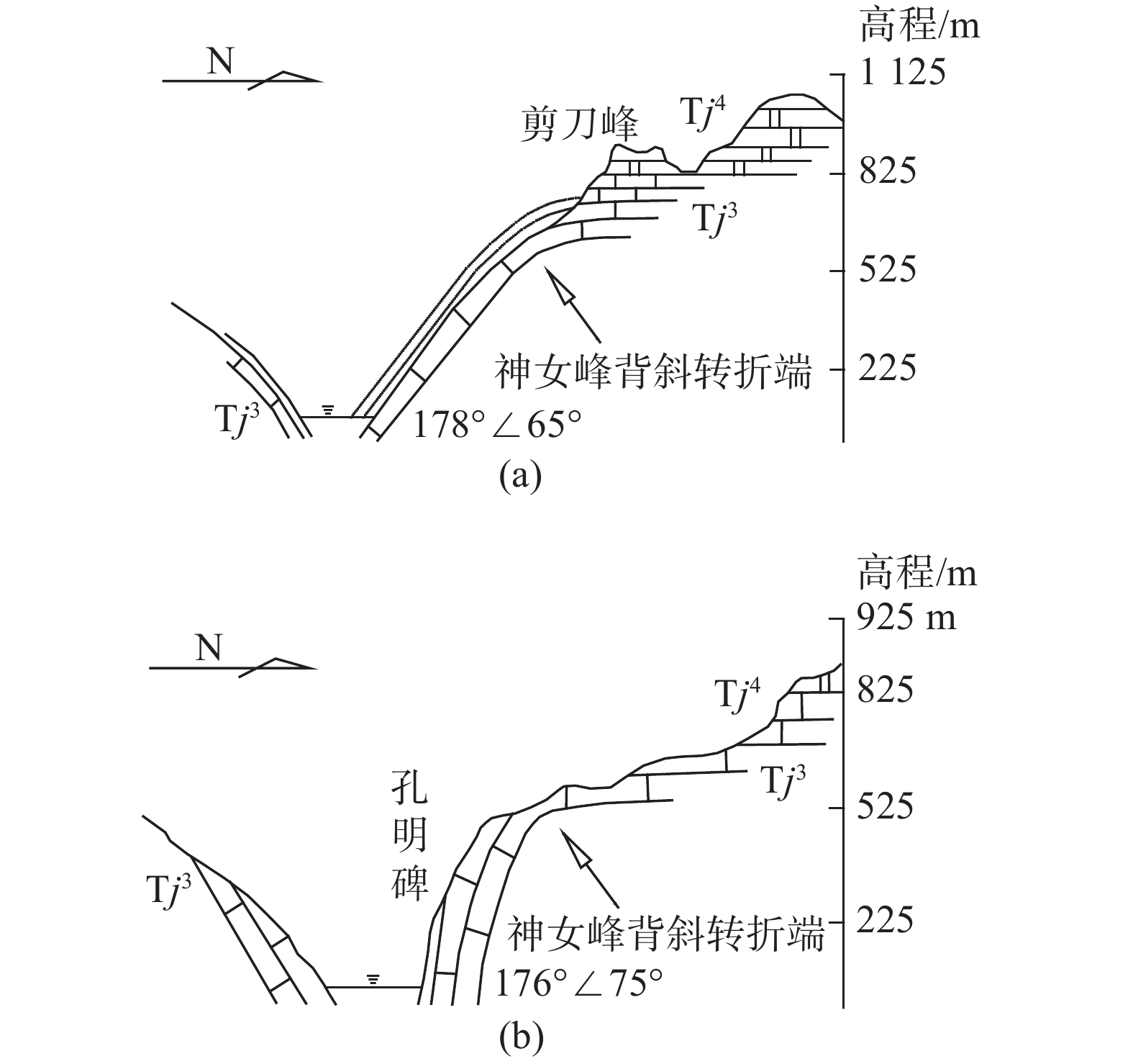
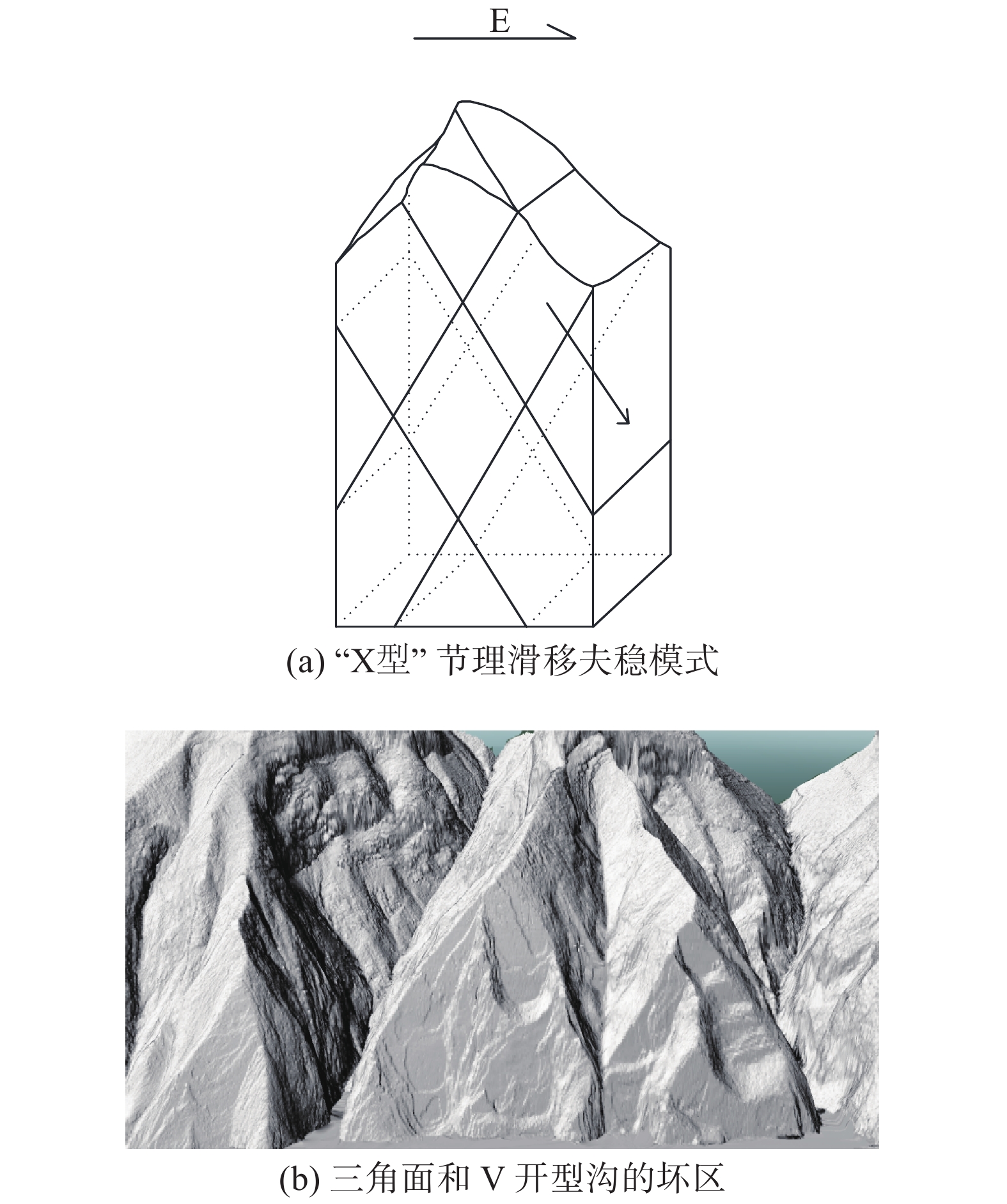
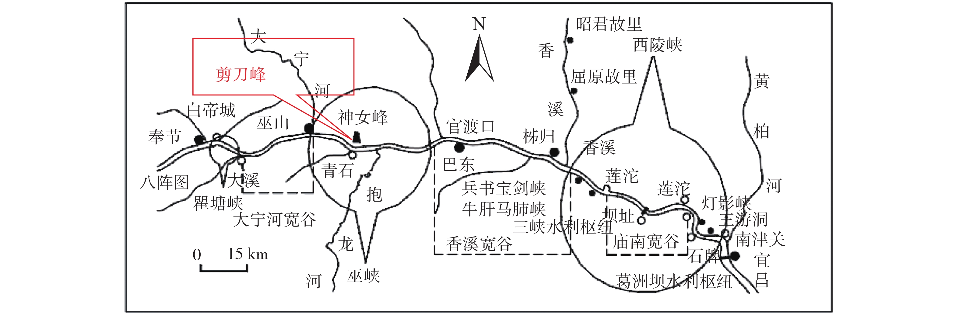
剪刀峰岸坡位于三峡库区巫山县巫峡左岸,全长2.1 km。受北侧神女峰箱状背斜及南侧神女溪—官渡口向斜影响,岸坡为陡倾顺层岩质岸坡。岸坡坡度45°~89°,整体为陡坡与的陡崖复合地貌;岸坡出露的第四系地层主要为崩坡积碎块石土,出露的基岩含三叠系大冶组三段、四段及嘉陵江组一段至四段地层,地层多元化;岩组类别主要为大冶组及嘉陵江组碳酸盐溶岩组成的坚硬岩组及嘉陵江组二段岩溶角砾岩组成的较软岩组;岩体结构从极薄层至巨厚层状,岸坡地形、地层、岩组及结构复杂。岸坡上游至下游,2.1 km范围内,坡体结构变化大,岸坡变形破坏特征差异大,成因机制及破坏模差异大。根据岸坡不同的地质条件及特征,划分为6个大段、6个亚段。研究从岸坡宏观变形、破坏特征出发,将岸坡目前的变形、破坏总结为“构造切割及卸荷”“局部压裂、滑移”“地表溶蚀”“消落区岩体劣化”四个方面,并从岸坡成因机制上分析了各段的破坏模式。此外,本次研究还分析了库水位以上岸坡及库水位消落区的岩体劣化特征,从岩体劣化的角度提出了沿层面渐进式松脱滑移、沿软弱夹层溃屈滑移、沿“X型”节理滑移、沿层面倾倒溃屈四种岩体劣化及破坏类型。
Abstract:Scissors peak bank slope is located in the left bank of Wushan gorge in the Three Gorges Reservoir area, with a total length of 2.1 km. Influenced by Shennv peak box anticline in the north and Shennv Xi-Guandukou syncline in the south, the bank slope is steeply sloping bedding rock bank slope. The slope of the bank is 45°~89°, and the whole is a composite landform of steep slope and steep cliff.The quaternary strata exposed on the bank slope are mainly cluvial gravel soil, and the exposed bedrock contains the strata of the 3rd and 4th members of the Triassic daye formation and the 1st to 4th members of the Jialingjiang formation. The strata are diversified.The rock groups are mainly hard rock group composed of carbonate lute of Daye formation and Jialingjiang formation and soft rock group composed of karst breccia of the second member of Jialingjiang formation. The rock mass structure ranges from very thin layer to very thick layer, and the slope topography, stratum, rock group and structure are complex. Within a range of 2.1 km from upstream to downstream of the bank slope, the slope structure changes greatly, the deformation and failure characteristics of the bank slope vary greatly, and the formation mechanism and failure modes differ greatly. According to the different geological conditions and characteristics of the slope, it can be divided into 6 large sections and 6 sub-sections.Based on the characteristics of the macroscopic deformation and failure of the bank slope, the current deformation and failure of the bank slope are summarized into four aspects: "structural cutting and unloading", "local fracturing, sliding", "surface dissolution", and "rock mass deterioration in the subsidence zone", and the failure modes of each section are analyzed from the perspective of the formation mechanism of the bank slope. In addition, this study also analyzed the deterioration characteristics of rock mass in the bank slope above the reservoir water level and the reservoir water level fluctuation area, and proposed four types of rock mass deterioration and failure types from the perspective of rock mass deterioration: progressive release slip along the plane, collapse slip along the weak interlayer, X-type joint slip, and toppling collapse along the plane.
-

-
表 1 岸坡分段及特征表
Table 1. Sectional characteristics of downstream bank slope
分段 航道里程编号 长度/m 主要分段
依据主要地质特征 第Ⅰ段 155 km+500 m~
155 km+600 m100 地形地貌、地层岩性、坡体结构及破坏模式 岸坡主要为大冶组4段及嘉陵江组一段中厚至厚层状灰岩,岸坡坡体相对较完整,破坏模式为表层岩体沿临空区域进行渐进式松脱-滑移破坏。 第Ⅱ段 Ⅱ-1段 155 km+265 m~
155 km+500 m235 地层岩性、坡体结构及破坏模式 岸坡主要为嘉陵江组一段中厚至厚层泥质灰岩,除消落带劣化严重外,其余坡体结构相对较完整,破坏模式为表层岩体沿临空区域崩塌-坠落。 Ⅱ-2段 155 km+086 m~
155 km+265 m179 地层岩性、坡体结构及破坏模式 该区域为轿顶峰1号斜坡区域,临江侧岸坡含嘉陵江组二段的岩溶角砾岩,此外主要岩体为薄至中厚层泥质灰岩,岸坡表层岩体劣化严重,局部呈碎裂状。岸坡除岩临空区域崩塌坠落外,后期局部区域还可能受软弱夹层及岩体劣化影响,出现滑移-溃屈破坏。 第Ⅲ段 154 km+783 m~
155 km+086 m303 地形地貌、地层岩性、坡体结构及破坏模式 该区域为轿顶峰2号斜坡区域,临江侧岸坡由嘉陵江组二段、三段地层组成,其中二段岩溶角砾岩呈连续分布,走向下游侧倾坡内。该段上游侧二段为薄至中厚层泥质灰岩及岩溶角砾岩,劣化较严重;下游为嘉陵江组薄至中厚层泥质灰岩及燧石灰岩,劣化相对上游较好。岸坡目前主要的变形破坏为临空区域以及浅表层的崩塌及滑移破坏后期局部区域还可能受软弱夹层及岩体劣化影响,出现滑移-溃屈破坏。 第Ⅳ段 154 km+527 m~
154 km+783 m256 地形地貌、地层岩性、坡体结构及破坏模式 临江面岸坡主要为嘉陵江组三段中厚至厚层燧石灰岩及泥质灰岩,后侧为嘉陵江组二段薄至中厚层泥质灰岩及岩溶角砾岩,但二段角砾岩发育在冲沟内侧至坡顶区域,对坡体整体稳定性影响小,岸坡主要的变形破坏为消落带区域的劣化以及上部局部区域的崩塌坠落。 第Ⅴ段 Ⅴ-1段 154 km+185 m~
154 km+527 m342 地形地貌、坡体结构及破坏模式 岸坡主要地层为嘉陵江组三段薄-中厚层泥质灰岩夹中厚层白云质灰岩,岸坡倾角变陡,主要发育的两组构造裂隙呈“X”型节理,岩体较破碎~较完整,前期差异劣化-崩塌形成了较多浅表层的凹岩腔。该区域岸坡主要变形为构造节理的切割及差异劣化后导致的浅表层崩塌。 Ⅴ-2段 153 km+885 m~
154 km+185 m300 地层岩性、坡体结构及破坏模式 临江面岸坡主要为嘉陵江组三段中厚层灰岩,局部夹中厚层白云质灰岩,岸坡倾角变陡,主要发育的两组构造裂隙呈“X”型节理,岩体相对较完整。该区域岸坡主要变形为构造节理的切割及差异劣化后导致的浅表层崩塌,下游侧边界受地形及构造切割影响易形成危岩发生滑移破坏。 第Ⅵ段 Ⅵ-1段 153 km+629 m~
153 km+885 m256 地形地貌、地层岩性、坡体结构及破坏模式 该段岸坡岩体主要为嘉陵江组三段中厚至厚层的灰岩夹中厚层状白云质灰岩,岩层层厚较厚,整体完整性较高,临江面岩体易发生卸荷,主要破坏模式为岩体卸荷、构造切割、差异劣化等导致岸坡浅表层局部发生崩塌坠落。 Ⅵ-2段 153 km+500 m~
153 km+629 m129 地层岩性、坡体结构及破坏模式 该段岸坡岩体主要为嘉陵江组三段厚层的灰岩,岩层层厚较厚,质地硬,整体完整性较高,临江面岩体卸荷程度高。该区段岩体近直立,局部呈反倾状,其可能出现倾倒式-溃屈破坏。  下载: 导出CSV
-
[1] TERZAGHI K. Measurement of Stresses in Rock[J]. Géotechnique,1962:105 − 124.
[2] 孙广忠. 岩体结构力学[M]. 北京: 科学出版社, 1988.
SUN Guangzhong. Rock mass structural mechanics [M]. Beijing:Science Press,1988. (in Chinese)
[3] 陈沅江, 潘长良, 曹平, 等. 层状岩质边坡蠕变破坏及其影响因素分析[J]. 勘察科学技术,2001(6):43 − 48. [CHEN Yuanjiang, PAN Changliang, CAO Ping, et al. Creep failure of layered rock slope and its influencing factors[J]. Investigation Science and Technology,2001(6):43 − 48. (in Chinese with English abstract)
[4] 张天贵, 李德均, 唐俊刚, 等. 重庆三峡库区长江干流库岸(巫山段左岸)地质灾害调查报告[R]. 重庆: 重庆市地质矿产勘查开发局107地质队, 2017.
ZHANG Tiangui, LI Dejun, TANG Jungang, et al. Geological disaster investigation report on the left bank of the main stream of Wushan section of the Yangtze River in the Three Gorges Reservoir area of Chongqing[R]. Chongqing: Geology No.107 of Chongqing , 2017. (in Chinese)
[5] 张枝华, 胡明军, 王 平, 等. 重庆三峡库区长江干流库岸(巫山段右岸)地质灾害调查报告[R]. 重庆: 重庆市地质灾害防治工程勘查设计院, 2017.
ZHANG Zhihua, HU Mingjun, WANG Ping, et al. Geological disaster investigation report on the right bank of the main stream of Wushan section of the Yangtze River in the Three Gorges Reservoir area of Chongqing[R]. Chongqing: Chongqing Exploration &Design Institute of Geological Hazard Control Engineering, 2017. (in Chinese)
[6] 王平, 胡明军, 吴坤达, 等. 重庆市三峡库区巫山县巫峡剪刀峰顺向岸坡调(勘)查[R]. 重庆: 重庆市二零八地质环境研究院有限公司, 2021.
WANG Ping, HU Mingjun, WU Kunda, et al. Survey along bank slope of scissors peak in Wushan County, Three Gorges Reservoir Area, Chongqing municipality [R]. Chongqing:Chongqing 208 Institute of Geological Environment Co. Ltd., 2021.(in Chinese)
[7] 王平, 郑涛, 黄波林, 等. 高陡峡谷岸坡变形破坏机理及预测预报研究—以长江三峡巫峡(重庆段)为例[R]. 重庆: 重庆市地质矿产勘查开发局208水文地质工程地质队, 2019.
WANG Ping, ZHEGN Tao, HUANG Bolin, et al. Study on deformation and failure mechanism and Forecast of high and steep canyon bank slope: A case study of Wuxia (Chongqing Section) in the Three Gorges of Yangtze River[R].Chongqing: 208 Hydrogeology Engineering Geo logy Team, Chongqing Bureau of Geology and Mineral Exploration and Development,2019. (in Chinese)
[8] 黄波林, 刘广宁, 王世昌, 等. 三峡库区高陡岸坡成灾机理研究[R]. 北京: 科学出版社, 2015.
HUANG Bolin, LIU Guangning, WANG Shichang, et al. Study on disaster mechanism of high and steep slope in Three Gorges Reservoir area [R]. Beijing:Science Press. 2015. (in Chinese)
[9] 张景昱, 宛良朋, 潘洪月, 等. 考虑水–岩作用特点的典型岸坡长期稳定性分析[J]. 岩土工程学报,2017,39(10):1851 − 1858. [ZHANG Jingyu, WAN Liangpeng, PAN Hongyue, et al. Long-term stability of bank slope considering characteristics of water-rock interaction[J]. Chinese Journal of Geotechnical Engineering,2017,39(10):1851 − 1858. (in Chinese with English abstract) doi: 10.11779/CJGE201710013
[10] 余姝, 张枝华, 黄波林, 等. 三峡库区青石-抱龙段顺层灰岩库岸坡变形破坏机理[J]. 中国地质灾害与防治学报,2019,30(3):18 − 23. [YU Shu, ZHANG Zhihua, HUANG Bolin, et al. Deformation mechanism of bedding limestone bank slope from Qingshi to Baolong, the Three Gorges area[J]. The Chinese Journal of Geological Hazard and Control,2019,30(3):18 − 23. (in Chinese with English abstract)
[11] 梁德明, 李长冬, 雍睿, 等. 基于参数劣化的软硬相间顺层边坡稳定性研究[J]. 岩土力学,2014,35(增刊1):195 − 202. [LIANG Deming, LI Changdong, YONG Rui, et al. Study of stability of soft-hard interbedded slope based on degradation of strength parameters[J]. Rock and Soil Mechanics,2014,35(Sup1):195 − 202. (in Chinese with English abstract)
[12] 陈小婷, 黄波林, 刘广宁, 等. 三峡库区平缓层状软硬相间斜坡变形模式变化分析[J]. 地质灾害与环境保护,2009,20(2):57 − 61. [CHEN Xiaoting, HUANG Bolin, LIU Guangning, et al. Analysising on deforming mode transforming of gentle soft-ard interbed slopes in Three Gorges reservoir[J]. Journal of Geological Hazards and Environment Preservation,2009,20(2):57 − 61. (in Chinese with English abstract) doi: 10.3969/j.issn.1006-4362.2009.02.013
[13] 胡明军, 张枝华, 黄波林, 等. 三峡工程重庆库区长江干流水位变动带岸坡长期强度弱化规律及防护措施示范研究[R]. 重庆: 重庆市地质矿产勘查开发局208水文地质工程地质队, 2021.
HU Mingjun, ZHANG Zhihua, HUANG Bolin, et al. A demonstration study on the long-term strength weakening law and protective measures of the Yangtze River slope in the water level fluctuation zone of the Three Gorges Project in Chongqing reservoir area [R]. Chongqing: 208 Hydrogeology Engineering Geology Team, Chongqing Bureau of Geology and Mineral Exploration and Development, 2021. (in Chinese)
[14] 黄波林, 殷跃平, 张枝华, 等. 三峡工程库区岩溶岸坡消落带岩体劣化特征研究[J]. 岩石力学与工程学报,2019,38(9):1786 − 1796. [HUANG Bolin, YIN Yueping, ZHANG Zhihua, et al. Study on deterioration characteristics of shallow rock mass in water the level fluctuation zone of Karst bank slopes in Three Gorges Reservoir area[J]. Chinese Journal of Rock Mechanics and Engineering,2019,38(9):1786 − 1796. (in Chinese with English abstract)
[15] 刘广宁, 齐信, 黄波林, 等. 库水波动带岸坡原位声波测试及劣化特性研究[J]. 工程地质学报,2017,25(2):367 − 375. [LIU Guangning, QI Xin, HUANG Bolin, et al. Sonic wave test and degradation characteristics of reservoir bank slope within water fluctuation belt[J]. Journal of Engineering Geology,2017,25(2):367 − 375. (in Chinese with English abstract)
[16] 殷跃平, 闫国强, 黄波林, 等. 三峡水库消落带斜坡岩体劣化过程地质强度指标研究[J]. 水利学报,2020,51(8):883 − 896. [YIN Yueping, YAN Guoqiang, HUANG Bolin, et al. Geological strength index of the slope rock mass deterioration process of the hydro-fluctuation belt in the Three Gorges Reservoir, China[J]. Journal of Hydraulic Engineering,2020,51(8):883 − 896. (in Chinese with English abstract)
[17] 蒋明镜, 刘蔚, 孙亚, 等. 考虑环境劣化非贯通节理岩体的直剪试验离散元模拟[J]. 岩土力学,2017,38(9):2728 − 2736. [JIANG Mingjing, LIU Wei, SUN Ya, et al. Discrete element simulation of direct shear test on rock mass containing discontinuous joints with environmental degradation[J]. Rock and Soil Mechanics,2017,38(9):2728 − 2736. (in Chinese with English abstract)
-


图(20)
表(1)
计量
- 文章访问数: 2124
- PDF下载数: 100
- 施引文献: 0