

Risk assessment of high-level collapse and landslide disasters in typical basin-edge mountainous areas in northeast Chongqing: A case study of the Ningqiao area in Wuxi
-
摘要:
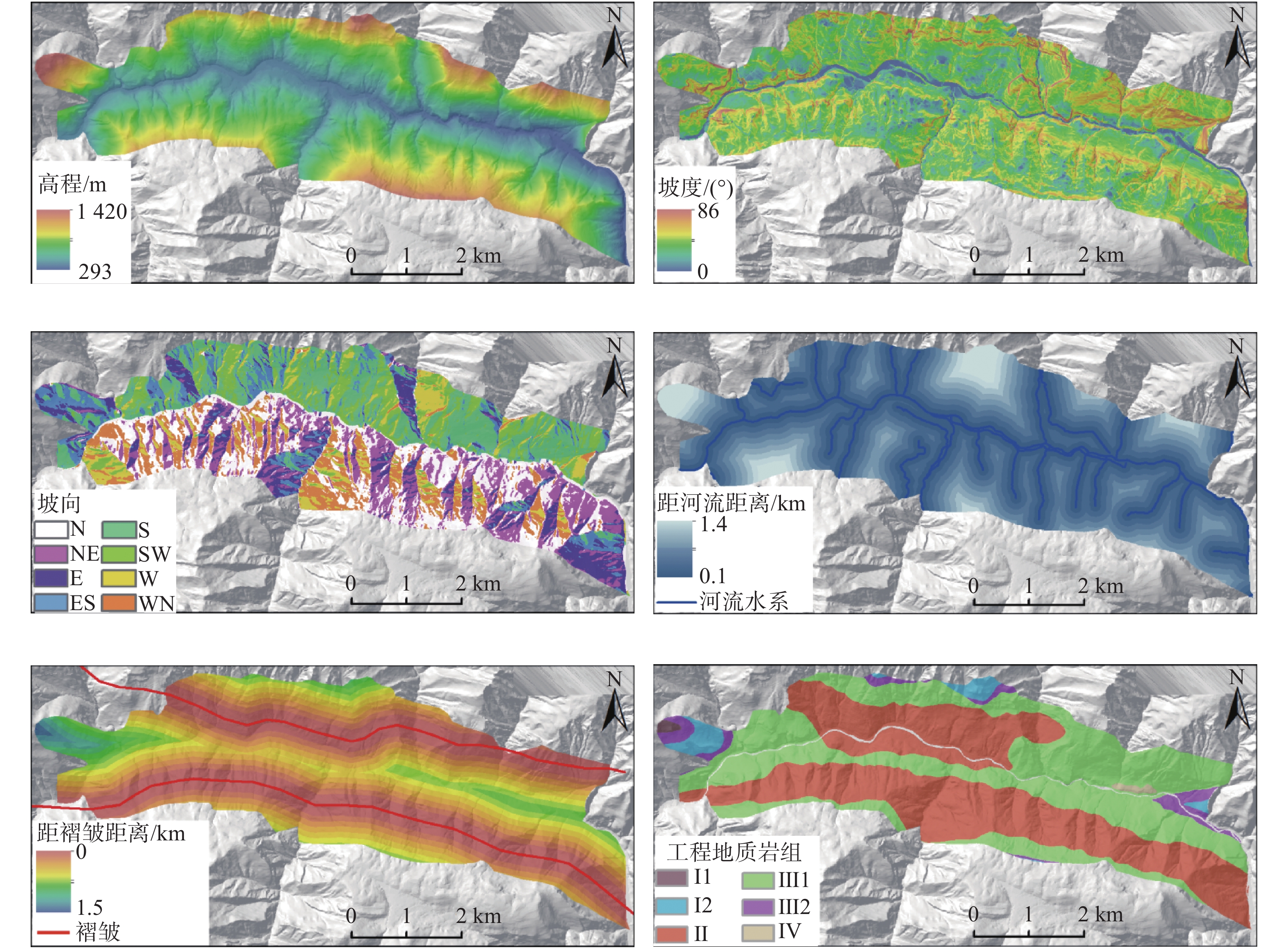
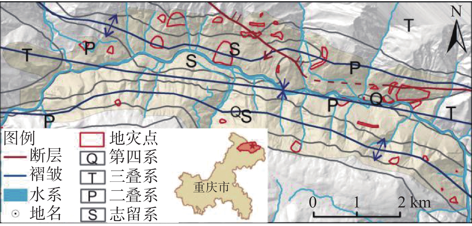
研究区位于重庆市巫溪县下堡镇内,属渝东盆缘山区,地形切割强烈,地质环境复杂,地质灾害频发。为了研究高陡峡谷区地质灾发育分布规律、风险区划,文章选取高程、坡度、坡向、工程地质岩组、距水系距离及距褶皱距离因子做为地质灾害易发性评价的影响因素,基于ArcGIS平台,利用信息量模型,定量评价了巫溪宁桥片区高陡峡谷区高位地质灾害的易发性,评价模型与地质灾害分布空间契合度较高,评价结果可信度较高。再结合易损性评价对研究区进行了地质灾害风险评价,最终得到研究区地质灾害风险评价模型。为该区域地质灾害防治提供了科学依据,同时对同类高陡峡谷地区地质灾害风险性评价及地质灾害防治具有借鉴意义。
Abstract:The study area is located in Xiabao Town, Wuxi County, Chongqing City. It belongs to the mountainous area on the edge of the Yudong Basin. It has strong topography, complex geological environment and frequent geological disasters. In order to study the development and distribution of geological hazards and risk zoning in high and steep canyons, this paper selects factors such as elevation, slope, aspect, engineering geological rock group, distance from water system, and distance from folds as the influencing factors for the assessment of geological hazard susceptibility, based on ArcGIS The platform uses the information model to quantitatively evaluate the susceptibility of high-level geological hazards in the high and steep gorge area of Wuxi Ningqiao area. The evaluation model has a high degree of correspondence with the distribution of geological hazards, and the evaluation results have a high degree of credibility. Combined with the vulnerability assessment, the geological disaster risk assessment of the study area was carried out, and finally the geological disaster risk assessment model of the study area was obtained. It provides a scientific basis for the prevention and control of geological disasters in the region, and at the same time has reference significance for the risk assessment of geological disasters and the prevention and control of geological disasters in similar high and steep canyons..
-
Key words:
- Wuxi /
- geodisaster /
- information model /
- risk assessment
-

-
表 1 各因子二级划分信息量值表
Table 1. Information values of factor classifications
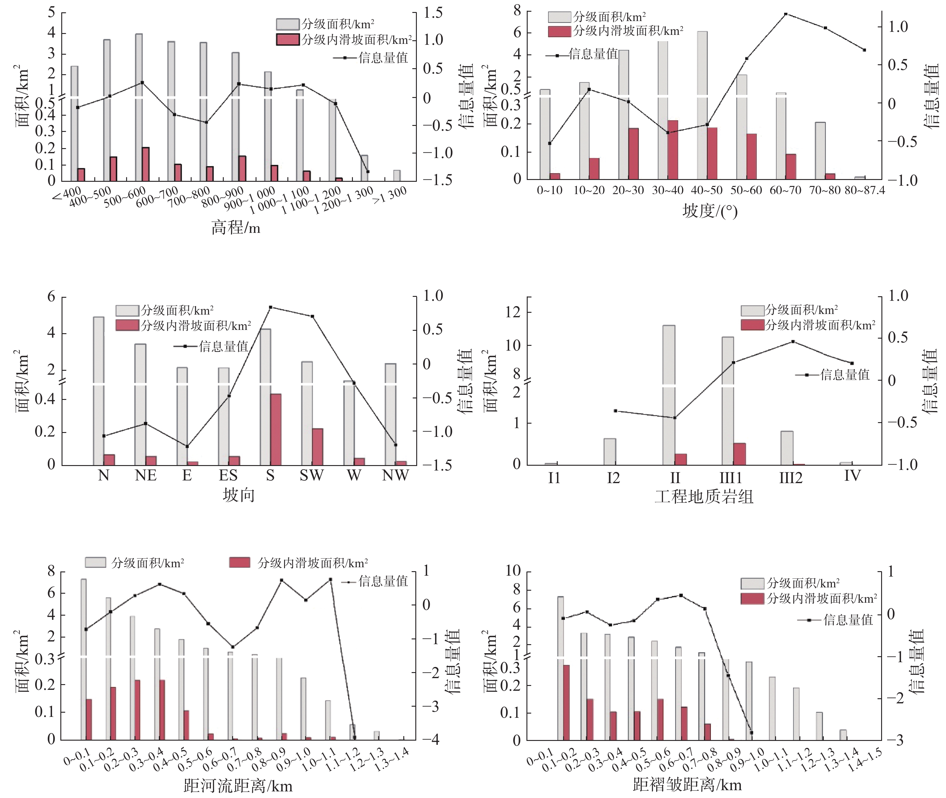
影响因子 因子分级 分级面积/km2 地灾面积/km2 滑坡信息量 高程/m <400 2.45 0.08 −0.17 400~500 3.71 0.15 0.02 500~600 4.00 0.21 0.27 600~700 3.63 0.11 −0.30 700~800 3.59 0.09 −0.44 800~900 3.10 0.16 0.24 900~1000 2.17 0.10 0.16 1000~1100 1.30 0.06 0.22 1100~1200 0.64 0.02 −0.11 1200~1300 0.16 0.00 −1.32 >1300 0.07 0.00 − 坡度/(°) 0~10 1.02 0.02 −0.52 10~20 1.66 0.08 0.20 20~30 4.61 0.19 0.03 30~40 7.98 0.22 −0.38 40~50 6.29 0.19 −0.27 50~60 2.33 0.17 0.60 60~70 0.72 0.09 1.19 70~80 0.21 0.02 1.00 80~87.4 0.01 0.00 0.71 坡向 N 5.16 0.07 −1.04 NE 3.66 0.06 −0.85 E 2.34 0.03 −1.19 ES 2.33 0.06 −0.43 S 4.49 0.45 0.92 SW 2.67 0.23 0.78 W 1.61 0.05 −0.24 WN 2.57 0.03 −1.17 距河流距离/km 0~0.1 7.42 0.15 −0.67 0.1~0.2 5.71 0.19 −0.16 0.2~0.3 3.99 0.22 0.33 0.3~0.4 2.84 0.22 0.67 0.4~0.5 1.86 0.11 0.38 0.5~0.6 1.04 0.02 −0.51 0.6~0.7 0.71 0.01 −1.21 0.7~0.8 0.48 0.01 −0.64 0.8~0.9 0.30 0.03 0.78 0.9~1.0 0.23 0.01 0.20 1.0~1.1 0.15 0.01 0.81 1.1~1.2 0.06 0.00 −3.89 1.2~1.3 0.03 0.00 − 1.3~1.4 0.00 0.00 − 工程地质岩组 Ⅰ1 0.08 0.00 − Ⅰ2 0.70 0.02 −0.31 Ⅱ1 11.73 0.31 −0.40 Ⅱ2 0.00 0.00 − Ⅱ3 0.00 0.00 − Ⅲ1 0.00 0.00 − Ⅲ2 11.00 0.59 0.29 Ⅲ3 0.89 0.06 0.55 Ⅳ1 0.00 0.00 − Ⅳ2 0.10 0.01 0.28 距褶皱距离/km 0~0.1 0.00 0.00 − 0.1~0.2 7.39 0.28 −0.07 0.2~0.3 3.52 0.15 0.09 0.3~0.4 3.33 0.11 −0.23 0.4~0.5 3.05 0.11 −0.13 0.5~0.6 2.61 0.15 0.38 0.6~0.7 1.95 0.12 0.47 0.7~0.8 1.37 0.06 0.15 0.8~0.9 0.72 0.01 −1.44 0.9~1.0 0.29 0.00 −2.79 1.0~1.1 0.23 0.00 − 1.1~1.2 0.19 0.00 − 1.2~1.3 0.10 0.00 − 1.3~1.4 0.04 0.00 − 1.4~1.5 0.00 0.00 −  下载: 导出CSV
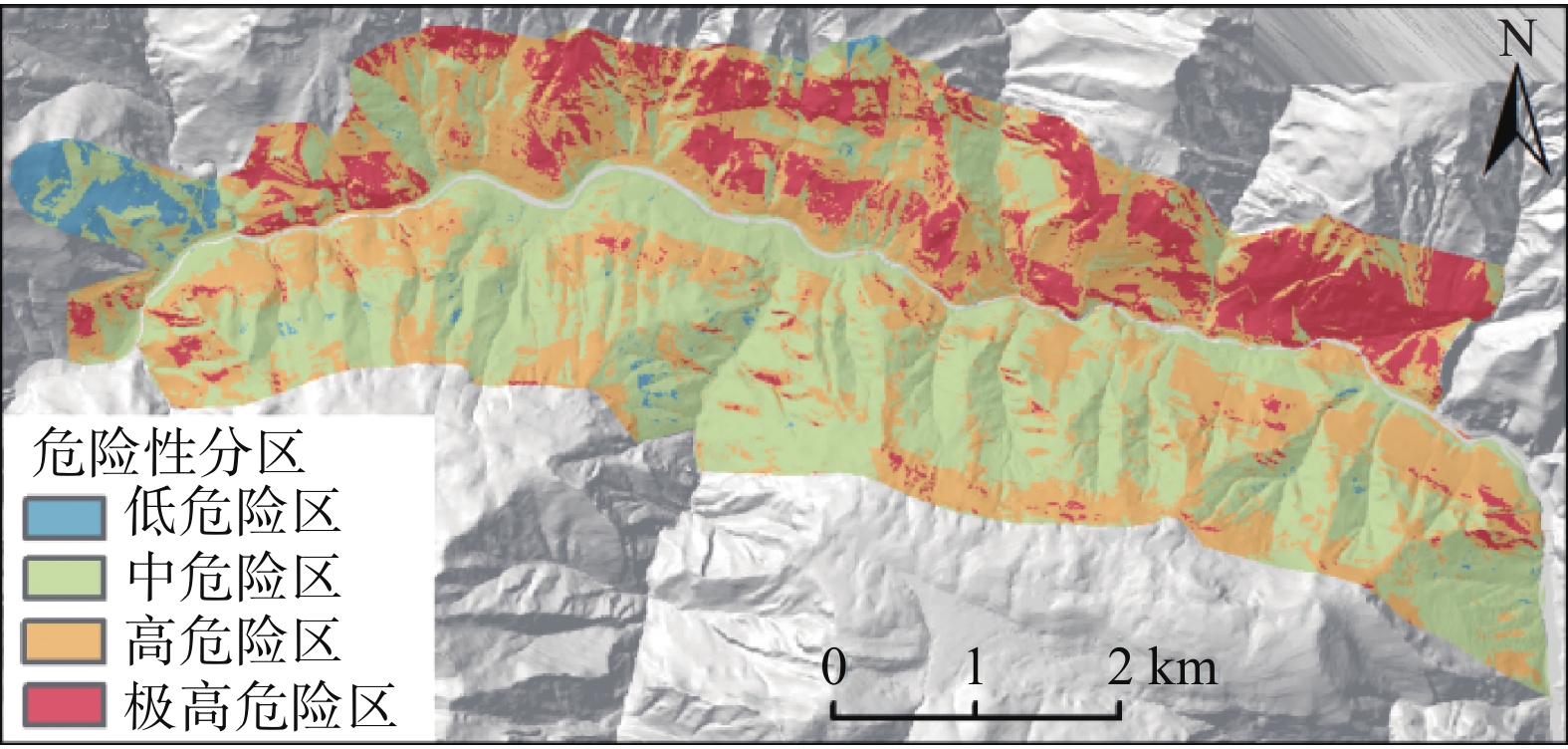
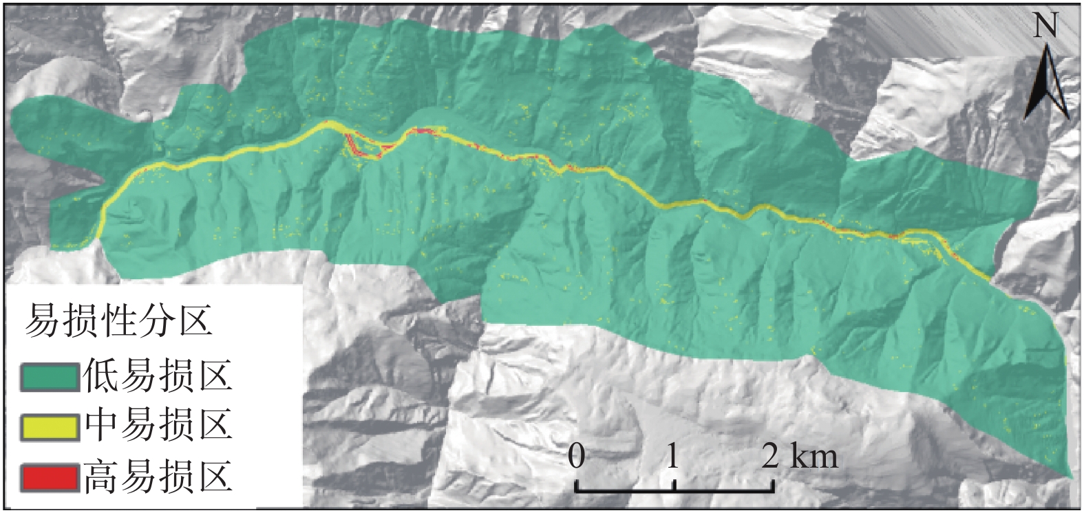
表 2 研究区地质灾害易发性分级统计
Table 2. Statistics analysis result of susceptibility classes
易发性分区 分区面积/km2 占比% 地灾点面积/km2 占比% 低易发区 1.96 8.02 0.00 0.17 中易发区 8.73 35.69 0.08 7.83 高易发区 9.15 37.41 0.29 28.96 极高易发区 4.61 18.86 0.62 62.75 高、极高易发性 13.77 56.28 0.91 91.71
下载: 导出CSV
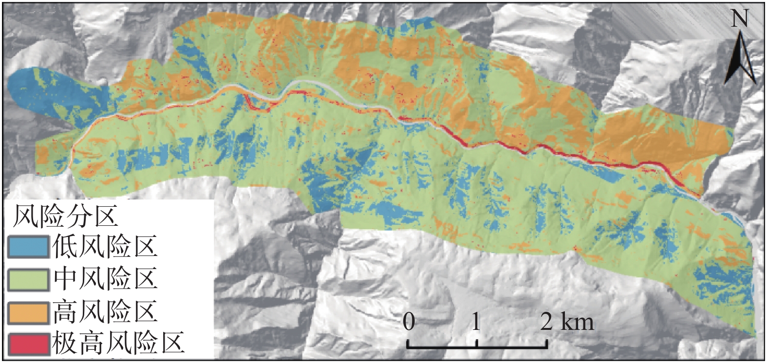
表 3 研究区地质灾害风险分级统计
Table 3. Statistics analysis result of risk classes
风险分区 分区面积/km2 百分比% 地灾点面积/km2 百分比% 低风险区 3.39 13.86 0.01 0.72 中风险区 15.48 63.31 0.33 33.56 高风险区 5.32 21.74 0.63 63.74 极高风险区 0.26 1.08 0.02 1.69 中及以上风险性 21.07 86.13 0.98 98.99
下载: 导出CSV
-
[1] NILSEN T H, BRABB E E. 18 slope-stability studies in the San Francisco Bay region, California[J]. Reviews in Engineering Geology,1977:233 − 244.
[2] 刘希林. 泥石流危险度判定的研究[J]. 灾害学,1988,3:10 − 15. [LIU Xilin. Study on determination of debris flow hazard[J]. Science of Disaster,1988,3:10 − 15. (in Chinese with English abstract)
[3] 张旭光, 李瑞冬. 基于层次分析法和GIS的甘肃省武山县地质灾害易发性区划研究[J]. 甘肃地质,2012,21(3):71 − 78. [ZHANG Xudong, LI Ruidong. Geo-hazard susceptibility zoning study in Wushan County, Gansu based on the combination of AHP and GIS[J]. Gansu Geology,2012,21(3):71 − 78. (in Chinese with English abstract)
[4] 彭令, 牛瑞卿, 赵艳南, 等. 基于核主成分分析和离子群优化支持向量机的滑坡位移预测[J]. 武汉大学学报(信息科学版),2013,38(2):148 − 161. [PENG Ling, NIU Ruiqing, ZHAO Yannan, et al. Prediction of landslide displacement based on KPCA and PSO-SVR[J]. Geomatics and Information Science of Wuhan University,2013,38(2):148 − 161. (in Chinese with English abstract)
[5] 许冲. 汶川地震滑坡灾害分布规律与危险性评价[J]. 岩石力学与工程学报,2012,31(2):432 − 432. [XU Chong. Distribution law and risk assessment for Wenchuan earthquake-triggered landslides[J]. Chinese Journal of Rock Mechanics and Engineering,2012,31(2):432 − 432. (in Chinese with English abstract) doi: 10.3969/j.issn.1000-6915.2012.02.024
[6] 孟祥瑞, 裴向军, 刘清华, 等. GIS支持下基于因子分析法的都汶路沿线地质灾害易发性评价[J]. 中国地质灾害与防治学报,2016,27(3):106 − 115. [MENG Xiangrui, PEI Xiangjun, LIU Qinghua, et al. GIS-based susceptibility assessment of geological hazards along the road from Dujiangyan to Wenchuan by factor analysis[J]. The Chinese Journal of Geological Hazard and Control,2016,27(3):106 − 115. (in Chinese with English abstract)
[7] 田春山, 刘希林, 汪佳. 基于CF和Logistic回归模型的广东省地质灾害易发性评价[J]. 水文地质工程地质,2016,43(6):154 − 161. [TIAN Chunshan, LIU Xilin, WANG Jia. Geohazard susceptibility assessment based on CF model and Logistic regression models in Guangdong[J]. Hydrogeology & Engineering Geology,2016,43(6):154 − 161. (in Chinese with English abstract)
[8] 张瑛. "5.12"汶川大地震震裂山体灾害勘察评价与治理设计方法研究[D]. 成都: 成都理工大学, 2009.
ZHANG Ying. Mountain disaster investigation assessment in 5.12 Wenchuan earthquake and control design methods research[D]. Chengdu: Chengdu University of Technology, 2009. (in Chinese with English abstract)
[9] 李滨, 殷跃平, 高杨, 等. 西南岩溶山区大型崩滑灾害研究的关键问题[J]. 水文地质工程地质,2020,47(4):5 − 13. [LI Bin, YIN Yueping, GAO Yang, et al. Critical issues in rock avalanches in the karst mountain areas of southwest China[J]. Hydrogeology & Engineering Geology,2020,47(4):5 − 13. (in Chinese with English abstract)
[10] 万佳威, 褚宏亮, 李滨, 等. 西藏嘉黎断裂带沿线高位链式地质灾害发育特征分析[J]. 中国地质灾害与防治学报,2021,32(3):51 − 60. [WAN Jiawei, CHU Hongliang, LI Bin, et al. Characteristics, types, main causes and development of high-position geohazard chains along the Jiali fault zone, Tibet, China[J]. The Chinese Journal of Geological Hazard and Control,2021,32(3):51 − 60. (in Chinese with English abstract)
-

图(8)
表(3)
计量
- 文章访问数: 1010
- PDF下载数: 137
- 施引文献: 0