

Application of receiver function method for characterizing the mantle transition zone structures in central and southern Alaska
-
摘要:
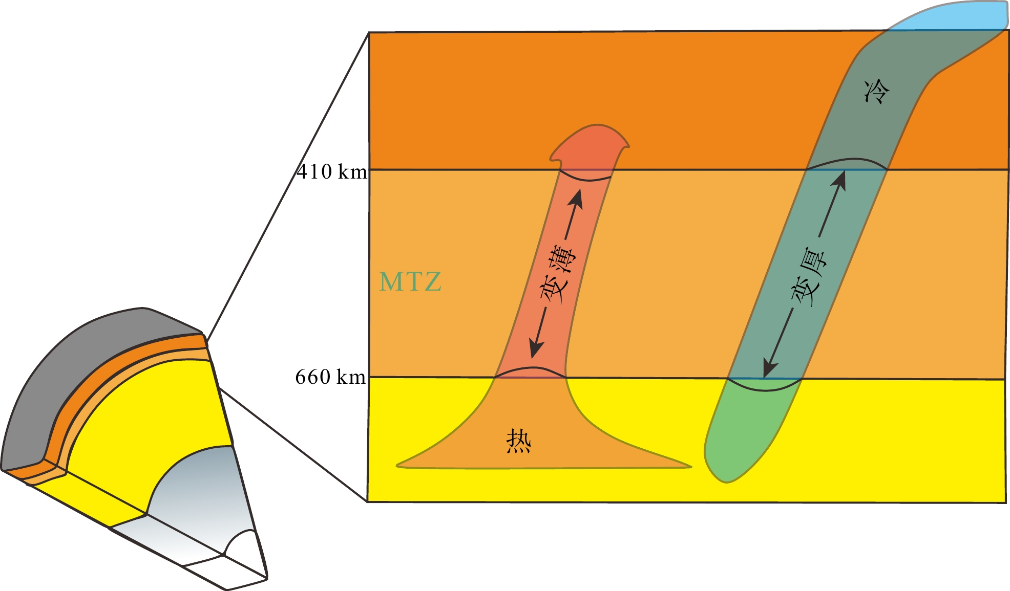
太平洋板块向北美板块俯冲,在北美洲阿拉斯加大陆边缘形成了碰撞造山带和俯冲构造带,前人对该区域阿拉斯加俯冲带地幔转换带的研究存在分歧,一种观点认为太平洋板块俯冲至阿拉斯加中南部下方的地幔转换带内部,引起地幔转换带增厚,另一种观点则认为地幔转换带增厚是由于库拉板块残留造成的。因此,研究阿拉斯加俯冲带区域地幔转换带的精确成像对于厘清太平洋板块俯冲机制和俯冲过程具有重要意义。本文利用美国地震联合学会(IRIS)在阿拉斯加区域布设的USArray部分固定台站接收到远震事件的波形资料,采用天然地震P波接收函数与共转换点道集叠加的方法,反演得到了阿拉斯加山脉和育空高原410 km、660 km间断面和地幔转换带的厚度结构。结果表明:由于太平洋板块俯冲至地幔转换带内部,使得410 km间断面在阿拉斯加山脉东部和育空高原与阿拉斯加山脉交界处的弧形区域出现了抬升现象,抬升幅度为0~20 km,进而导致在该区域出现不同程度的地幔转换带增厚的现象,验证了第一种观点。另外,该地区地幔转换带结构显示,660 km间断面在阿拉斯加山脉东部以及阿拉斯加山脉与育空高原交界的东部出现下沉现象,故此推测阿拉斯加中南部部分区域太平洋板块已经俯冲至地幔转换带底部。
Abstract:The subduction of the Pacific Plate towards the North American Plate has formed a collisional mountain belt and subduction zone at the edge of the continent in Alaska. Previous studies on the mantle transition zone beneath the Alaska subduction were in debate. It is believed that the thickening of the transition zone is due to the subduction of the Pacific Plate, or due to the thickening is caused by the residual Kula Plate. Therefore, accurate imaging of mantle transition zones in the Alaskan subduction zone is of great significance for understanding the subduction mechanism and courses of the Pacific Plate. This study provided waveform data from teleseismic events received in several stations of the US Array deployed by Incorporated Research Institutions for Seismology (IRIS) in the Alaska region, and adopts the natural earthquake P-wave receiver function and common conversion point stacking method to obtain 410 km and 660 km discontinuity sections and mantle transition zone thickness structure of the Alaska Range and Yukon Plateau. The new results show that due to the subduction of the Pacific Plate into the mantle transition zone, a 410 km long discontinuity is uplifted in the arc-shaped area of the eastern Alaska Mountains and the junction of the Yukon Plateau and the Alaska Mountains, with an uplift of 0~20 km, which in turn led to different degrees of thickening of the mantle transition zone in this area, which verifies the first view. In addition, the structure of the mantle transition zone in this area shows that a 660 km long discontinuity has subsided in the eastern part of the Alaska Mountain Range and the eastern part of the border between the Alaska Mountains and the Yukon Plateau. Therefore, it is assumed that the Pacific Plate in parts of south-central Alaska has subducted to the bottom of the mantle transition zone.
-
Key words:
- receiver function /
- mantle transition zone /
- discontinuity /
- Alaska
-

-
[1] 柳存喜, 王志. 南阿拉斯加地壳及上地幔结构成像研究[J]. 地球物理学报, 2014, 57(7 doi: 10.6038/cjg20140708
LIU Cunxi, WANG Zhi. Structure imaging of the crust and upper mantle in south of Alaska [J]. Chinese Journal of Geophysics, 2014, 57(7). doi: 10.6038/cjg20140708
[2] Zhao D, Yamamoto Y, Yanada T. Global mantle heterogeneity and its influence on teleseismic regional tomography. Gondwana Research, 2013, 23(2): 595-616
[3] Martin-Short R, Allen R M, Bastow I D. Subduction geometry beneath south central Alaska and its relationship to volcanism. Geophysical Research Letters, 2016, 43(18): 9509-9517
[4] Burdick S, Vernon F L, Martynov V, et al. Model Update May 2016: Upper-Mantle Heterogeneity beneath North America from Travel-Time Tomography with Global and USArray Data. Seismological Research Letters, 2017, 88(2A): 319- 325
[5] van der Meer D G, van Hinsbergen D J J, Spakman W. Atlas of the underworld: slab remnants in the mantle, their sinking history, and a new outlook on lower mantle viscosity [J]. Tectonophysics, 2018, 723: 309-448. doi: 10.1016/j.tecto.2017.10.004
[6] Ai Y S, Zheng T Y, Xu W W, et al. A complex 660 km discontinuity beneath northeast China [J]. Earth and Planetary Science Letters, 2003, 212(1-2): 63-71. doi: 10.1016/S0012-821X(03)00266-8
[7] Ferris A, Abers G A, Christensen D H, et al. High resolution image of the subducted Pacific (?) plate beneath central Alaska, 50-150 km depth [J]. Earth and Planetary Science Letters, 2003, 214(3-4): 575-588. doi: 10.1016/S0012-821X(03)00403-5
[8] Rondenay S, Abers G A, van Keken P E. Seismic imaging of subduction zone metamorphism [J]. Geology, 2008, 36(4): 275-278. doi: 10.1130/G24112A.1
[9] Dahm H H, Gao S S, Kong F S, et al. Topography of the mantle transition zone discontinuities beneath Alaska and its geodynamic implications: constraints from receiver function stacking. Journal of Geophysical Research: Solid Earth, 2017, 122(12): 10352-10363
[10] van Stiphout A M, Cottaar S, Deuss A. Receiver function mapping of mantle transition zone discontinuities beneath Alaska using scaled 3-D velocity corrections [J]. Geophysical Journal International, 2019, 219(2): 1432-1446. doi: 10.1093/gji/ggz360
[11] 肖勇. 阿留申-阿拉斯加俯冲带和汤加-斐济俯冲带地幔过渡带结构研究[D]. 北京: 中国地震局地球物理研究所硕士学位论文, 2020.
XIAO Yong. Study of the mantle transition zone structure beneath Alaska-Aleutian subduction zone and Tonga-Fiji subduction zone[D]. Master Dissertation of Institute of Geophysics, China Earthquake Administration, 2020.
[12] Qi C, Zhao D P, Chen Y. Search for deep slab segments under Alaska [J]. Physics of the Earth and Planetary Interiors, 2007, 165(1-2): 68-82. doi: 10.1016/j.pepi.2007.08.004
[13] van Stiphout T, Kissling E, Wiemer S, et al. Magmatic processes in the Alaska subduction zone by combined 3-D b value imaging and targeted seismic tomography [J]. Journal of Geophysical Research:Solid Earth, 2009, 114(B11): B11302.
[14] You T, Zhao D P. Seismic anisotropy and heterogeneity in the Alaska subduction zone [J]. Geophysical Journal International, 2012, 190(1): 629-649. doi: 10.1111/j.1365-246X.2012.05512.x
[15] Ai Y S, Zhao D P, Gao X, et al. The crust and upper mantle discontinuity structure beneath Alaska inferred from receiver functions [J]. Physics of the Earth and Planetary Interiors, 2005, 150(4): 339-350. doi: 10.1016/j.pepi.2004.12.002
[16] Maguire R, Ritsema J, Bonnin M, et al. Evaluating the Resolution of Deep Mantle Plumes in Teleseismic Traveltime Tomography. Journal of Geophysical Research: Solid Earth, 2018, 123(1): 384-400
[17] Jiang C X, Schmandt B, Ward K M, et al. Upper mantle seismic structure of Alaska from Rayleigh and S wave tomography [J]. Geophysical Research Letters, 2018, 45(19): 10350-10359. doi: 10.1029/2018GL079406
[18] Gou T, Zhao D P, Huang Z C, et al. Aseismic deep slab and mantle flow beneath Alaska: insight from anisotropic tomography [J]. Journal of Geophysical Research:Solid Earth, 2019, 124(2): 1700-1724. doi: 10.1029/2018JB016639
[19] Rossi G, Abers G A, Rondenay S, et al. Unusual mantle Poisson's ratio, subduction, and crustal structure in central Alaska [J]. Journal of Geophysical Research:Solid Earth, 2006, 111(B9): B09311.
[20] Haeussler P, Coe R S, Onstott T C. Paleomagnetism of the late Triassic hound island volcanics: revisited [J]. Journal of Geophysical Research:Solid Earth, 1992, 97(B13): 19617-19639. doi: 10.1029/92JB01361
[21] McClelland W C, Gehrels G E, Saleeby J B. Upper Jurassic-lower cretaceous basinal strata along the cordilleran margin: implications for the accretionary history of the Alexander-Wrangellia-Peninsular terrane [J]. Tectonics, 1992, 11(4): 823-835. doi: 10.1029/92TC00241
[22] Langston C A. Corvallis, Oregon, crustal and upper mantle receiver structure from teleseismic P and S waves [J]. Bulletin of the Seismological Society of America, 1977, 67(3): 713-724. doi: 10.1785/BSSA0670030713
[23] Vinnik L P. Detection of waves converted from P to SV in the mantle [J]. Physics of the Earth and Planetary Interiors, 1977, 15(1): 39-45. doi: 10.1016/0031-9201(77)90008-5
[24] Phinney R A. Structure of the Earth's crust from spectral behavior of long-period body waves. Journal of Geophysical Research, 1964, 69(14): 2997-3017.
[25] Xu M J, He J. Seispy: Python module for batch calculation and postprocessing of receiver functions [J]. Seismological Research Letters, 2023, 94(2A): 935-943. doi: 10.1785/0220220288
[26] 朱智昊. 利用接收函数方法研究中国中东部410和660千米间断面起伏[D]. 中国科学技术大学硕士学位论文, 2018
ZHU Zhihao. Topography of the 410-and 660-km discontinuities beneath the central and eastern China using receiver function[D]. Master Dissertation of University of Science and Technology of China, 2018.
-
 下载:
下载:


图(12)
计量
- 文章访问数: 424
- PDF下载数: 71
- 施引文献: 0