

Identification of suitable sites for open and bore well using ground magnetic survey
-
Abstract:
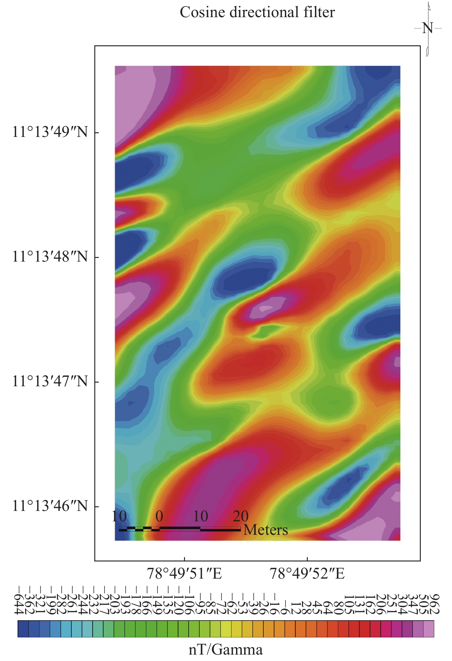
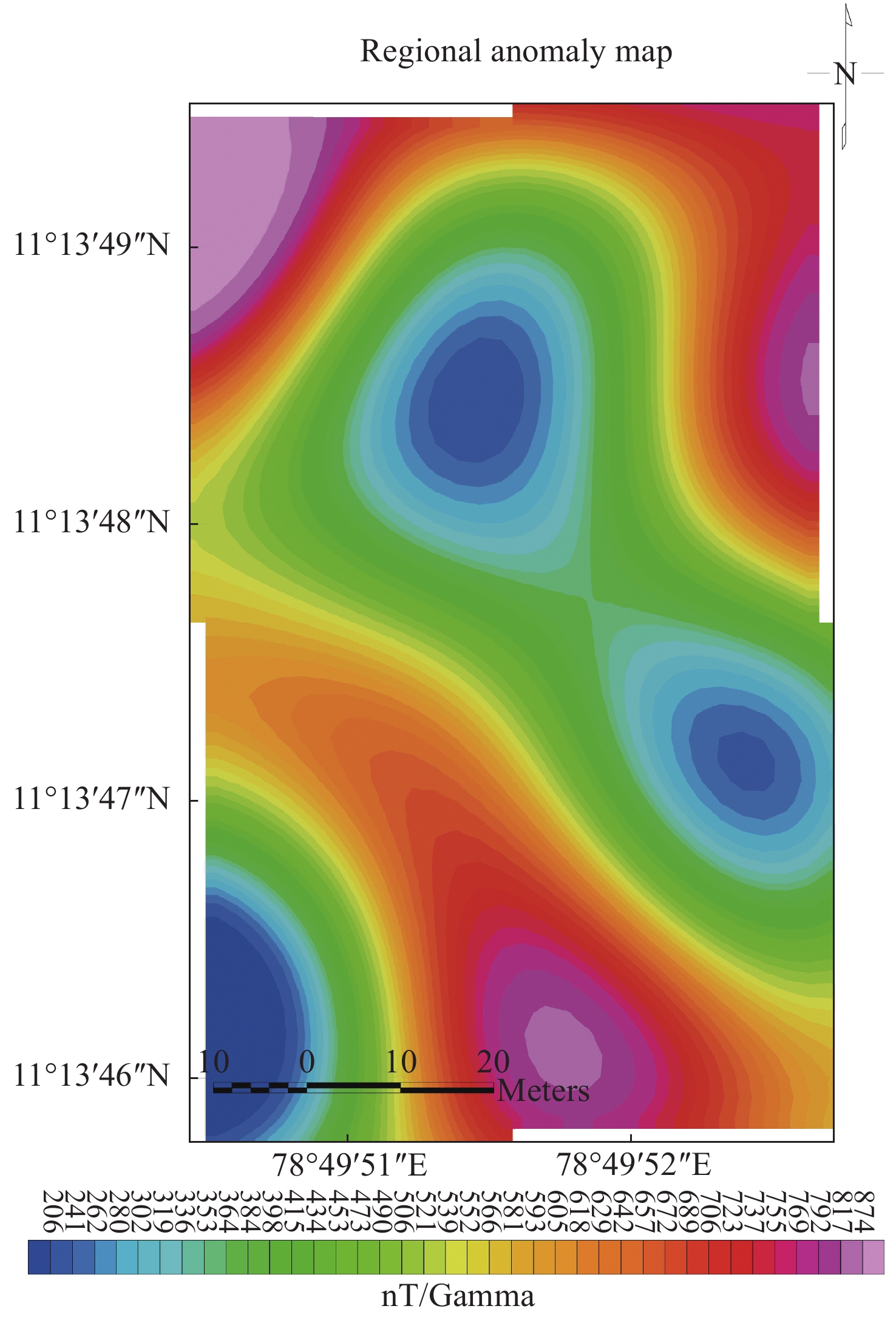
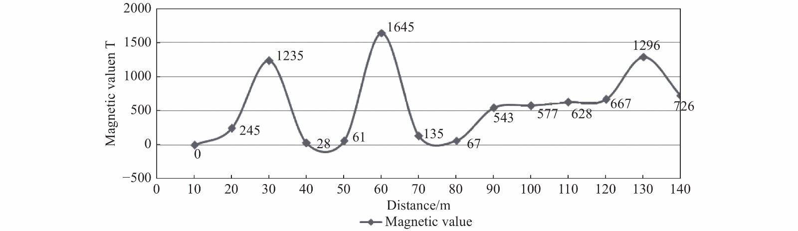
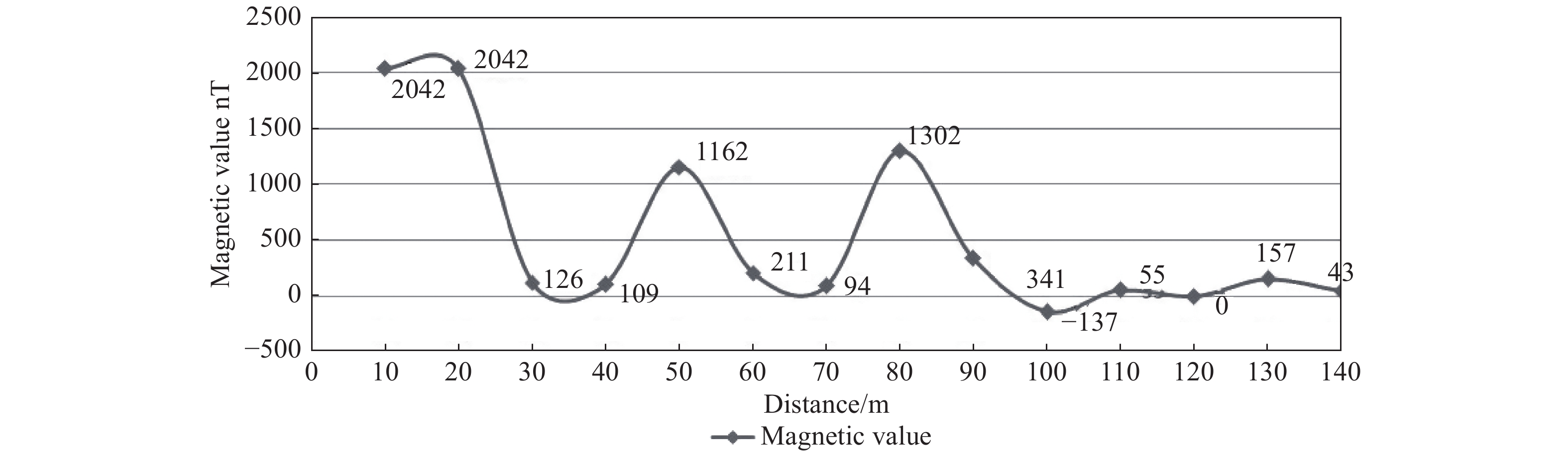
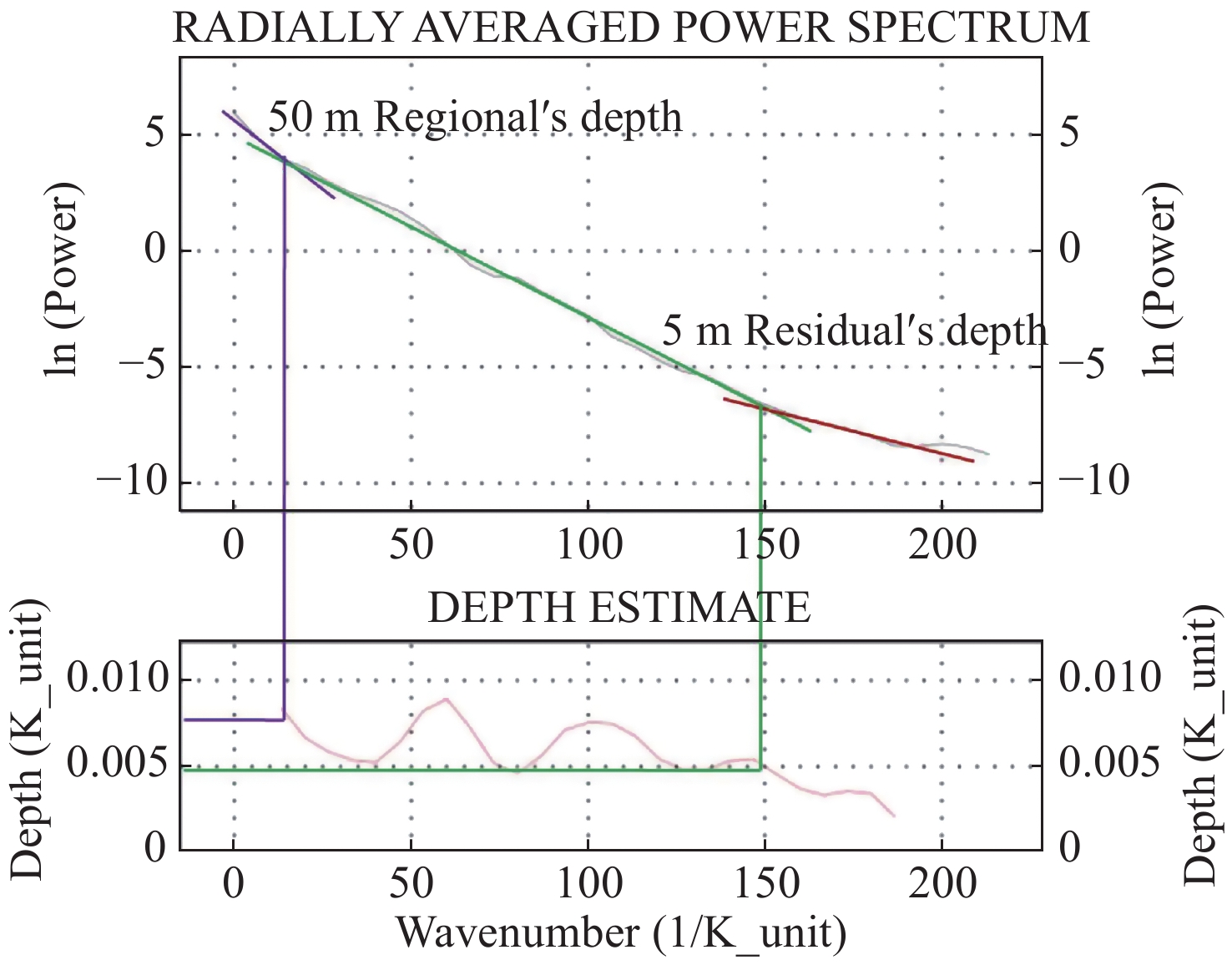
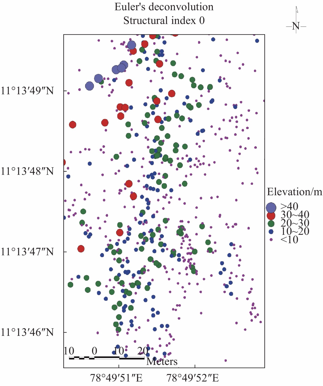
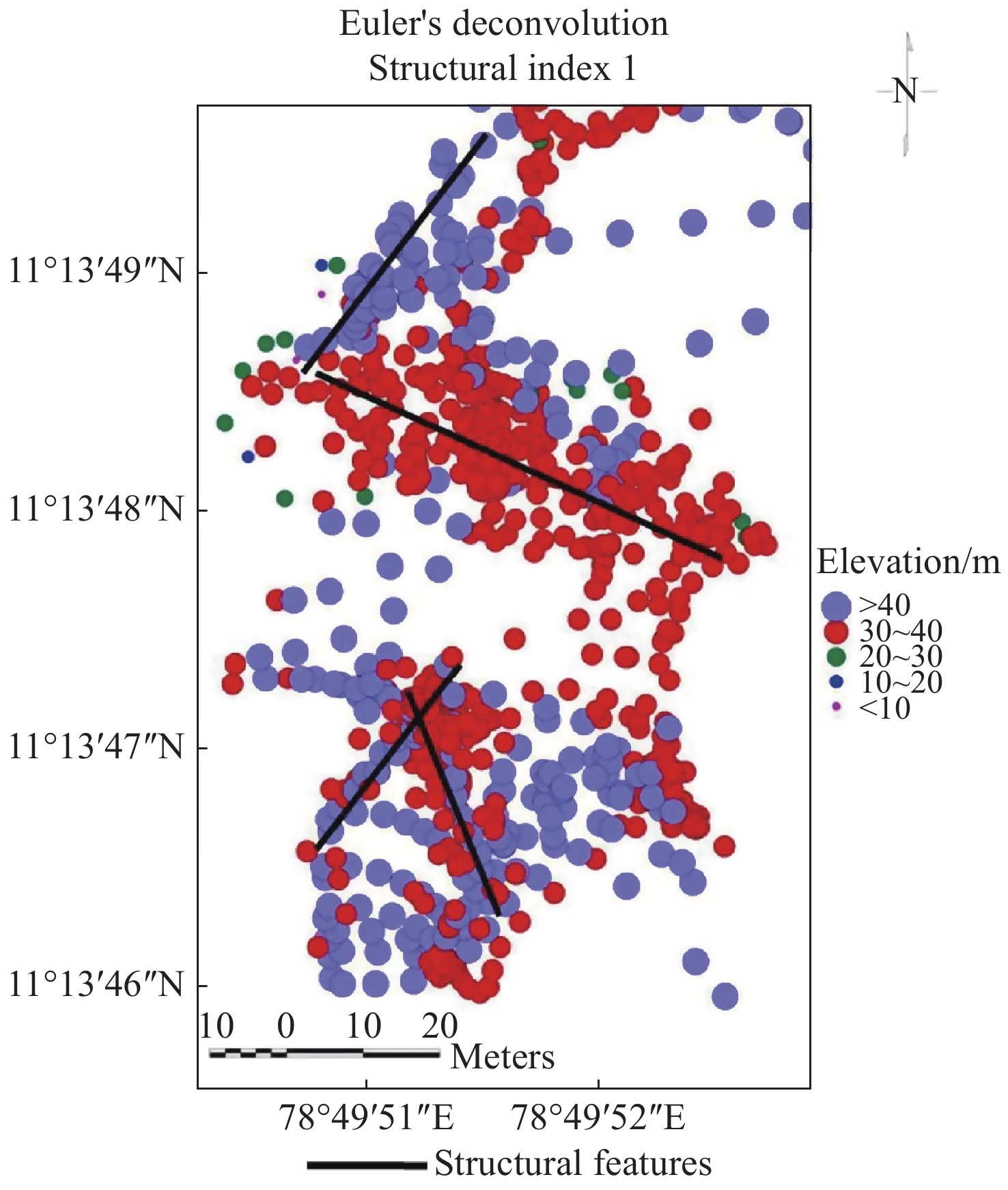
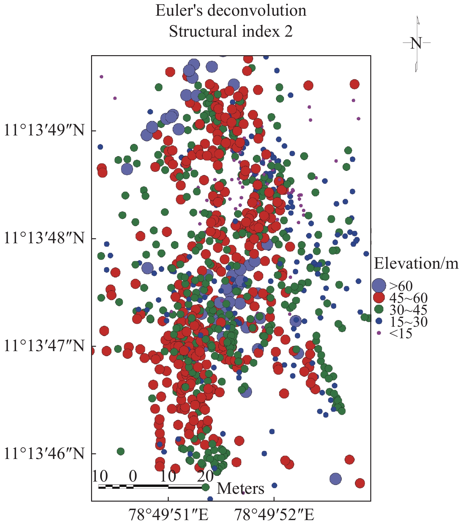
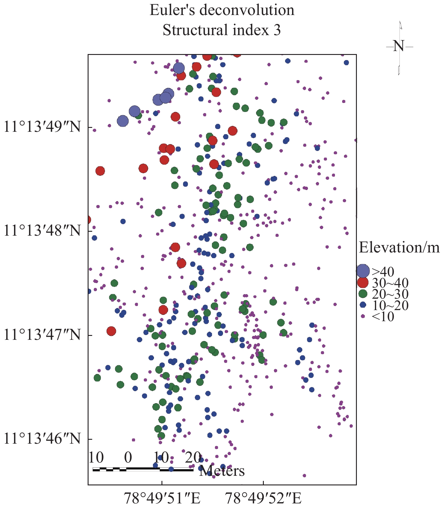
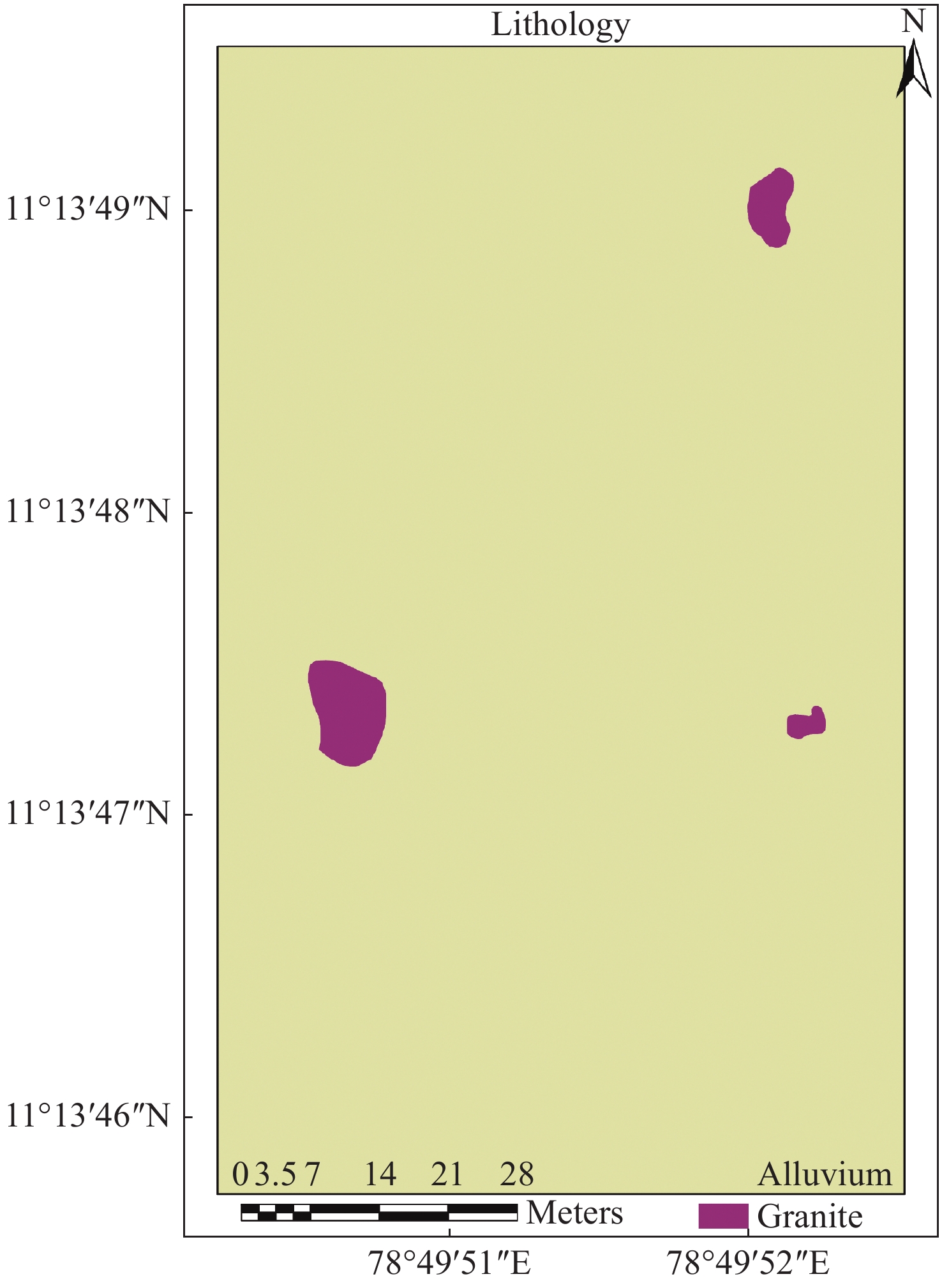
The study aims to identify a suitable site for open and bore well in a farmhouseusing ground magnetic survey in south India. It also aims to define depth to granitoid and structural elements which traverse the selected area. Magnetic data (n=84) measured, processed and interpreted as qualitative and quantitatively. The results of total magnetic intensities indicate that the area is composed of linear magnetic lows trending NE-SW direction and circular to semi-circular causative bodies. The magnetic values ranged from −137 nT to 2345 nT with a mean of 465 nT. Reduction to equator shows significant shifting of causative bodies in the southern and northern directions. Analytical signal map shows exact boundary of granitic bodies. Cosine directional filter has brought out structural element trending NE-SW direction. Results of individual profile brought to light structurally weak zone between 90 m and 100 m in all the profile lines. Sudden decrease of magnetic values from 2 042 nT to 126 nT noticed in profile line 6 between 20 m and 30 m indicates fault occurrence. Magnetic breaks obtained from these maps were visualized, interpreted and identified two suitable sites for open and bore well. Radially averaged power spectrum estimates depth of shallow and deep sources in 5 m and 50 m, respectively. Euler method has also been applied to estimate depth of granitoid and structural elements using structural indexes 0, 1, 2, and 3 and found depth ranges from <10 m to >90 m. Study indicates magnetic method is one of the geophysical methods suitable for groundwater exploration and site selection for open and borewells.
-
Key words:
- Magnetic method /
- Groundwater exploration /
- Euler deconvolution /
- Open well
-

-
Table 1. Magnetic data of the study area
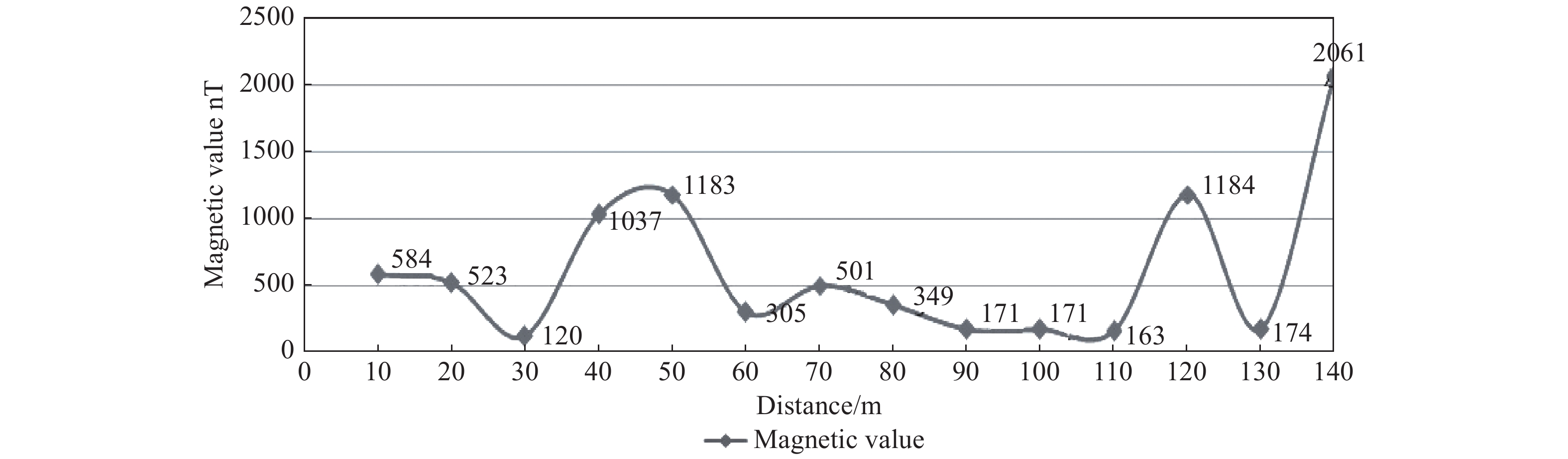
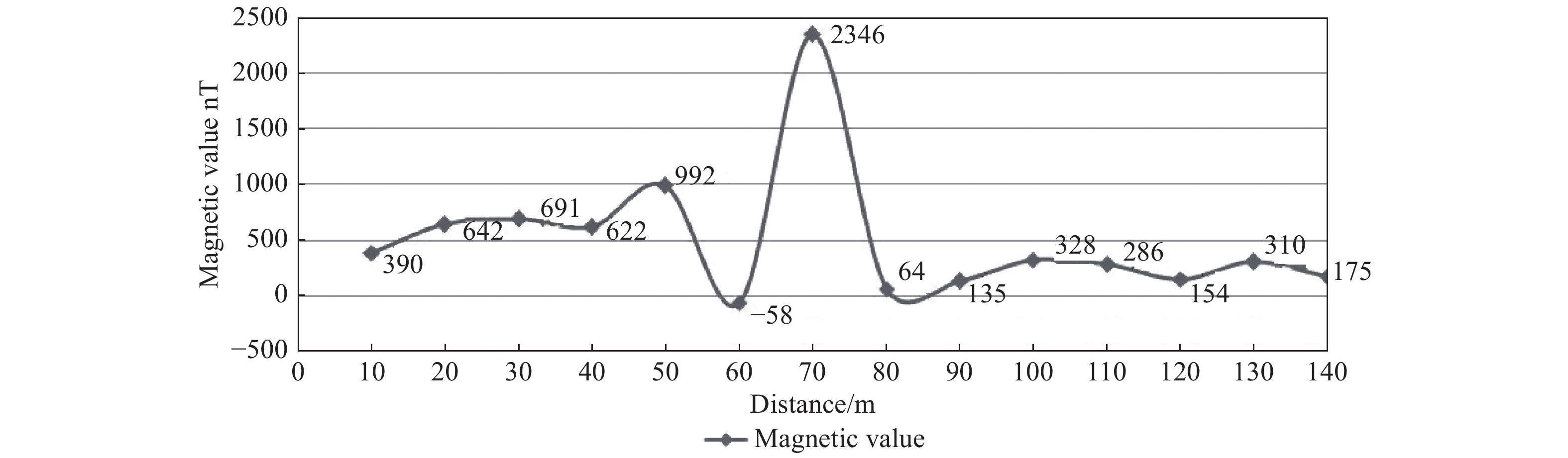
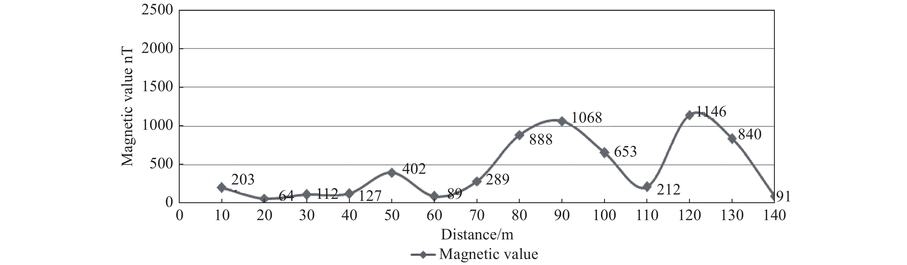
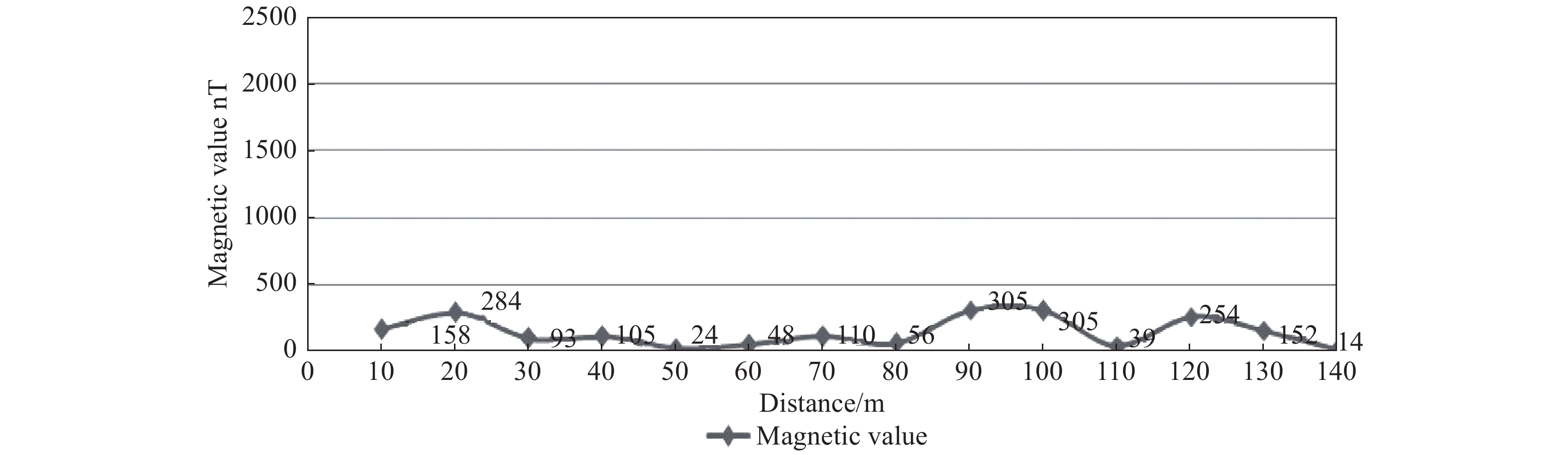
S.No Profile line Longitude Latitude Magnetic Data (nT) Filed Reading time Base value Corrected value 1 L1 78.8313 11.2295 41 399 11.2 41 399.00 0 2 L1 78.8313 11.2296 41 154 11.21 41 398.93 245 3 L1 78.8313 11.2296 40 164 11.22 41 398.85 1 235 4 L1 78.8313 11.2297 41 371 11.23 41 398.78 28 5 L1 78.8313 11.2297 41 338 11.24 41 398.71 61 6 L1 78.8313 11.2298 39 754 11.25 41 398.64 1 645 7 L1 78.8313 11.2298 41 264 11.26 41 398.56 135 8 L1 78.8313 11.2299 41 331 11.27 41 398.49 67 9 L1 78.8313 11.23 40 855 11.28 41 398.42 543 10 L1 78.8313 11.23 40 821 11.29 41 398.35 577 11 L1 78.8313 11.2301 40 770 11.3 41 398.27 628 12 L1 78.8313 11.2302 40 731 11.31 41 398.20 667 13 L1 78.8313 11.2303 40 102 11.32 41 398.13 1 296 14 L1 78.8313 11.2304 40 672 11.33 41 398.05 726 15 L2 78.8311 11.2303 40 814 11.34 41 397.98 584 16 L2 78.8312 11.2303 40 875 11.35 41 397.91 523 17 L2 78.8312 11.2302 41 278 11.36 41 397.84 120 18 L2 78.8312 11.2302 40 361 11.37 41 397.76 1 037 19 L2 78.8312 11.2301 40 215 11.38 41 397.69 1 183 20 L2 78.831 11.23 41 093 11.39 41 397.62 305 21 L2 78.8312 11.23 40 897 11.4 41 397.55 501 22 L2 78.8312 11.2299 41 048 11.41 41 397.47 349 23 L2 78.8312 11.2298 41 226 11.42 41 397.40 171 24 L2 78.8312 11.2298 41 226 11.43 41 397.33 171 25 L2 78.8312 11.2297 41 234 11.44 41 397.25 163 26 L2 78.8312 11.2296 40 213 11.45 41 397.18 1 184 27 L2 78.831 11.2297 41 223 11.46 41 397.11 174 28 L2 78.8311 11.2294 39 336 11.47 41 397.04 2 061 29 L3 78.8313 11.2296 41 007 11.48 41 396.96 390 30 L3 78.8309 11.2295 40 755 11.49 41 396.89 642 31 L3 78.831 11.2296 40 706 11.5 41 396.82 691 32 L3 78.8312 11.2295 40 775 11.51 41 396.75 622 33 L3 78.8312 11.2296 40 405 11.52 41 396.67 992 34 L3 78.831 11.2297 41 455 11.53 41 396.60 −58 35 L3 78.831 11.2298 39 051 11.54 41 396.53 2 346 36 L3 78.831 11.2299 41 332 11.55 41 396.45 64 37 L3 78.831 11.23 41 261 11.56 41 396.38 135 38 L3 78.831 11.2301 41 068 11.57 41 396.31 328 39 L3 78.831 11.2301 41 110 11.58 41 396.24 286 40 L3 78.831 11.2303 41 242 11.59 41 396.16 154 41 L3 78.831 11.2302 41 086 12 41 396.09 310 42 L3 78.831 11.2303 41 221 12.01 41 396.02 175 43 L4 78.8309 11.2303 41 193 12.02 41 395.95 203 44 L4 78.8309 11.2303 41 332 12.03 41 395.87 64 45 L4 78.8309 11.2302 41 284 12.04 41 395.80 112 46 L4 78.8309 11.2301 41 269 12.05 41 395.73 127 47 L4 78.8309 11.2301 40 994 12.06 41 395.65 402 48 L4 78.8309 11.23 41 307 12.07 41 395.58 89 49 L4 78.8309 11.2299 41 107 12.08 41 395.51 289 50 L4 78.8309 11.2298 40 507 12.09 41 395.44 888 51 L4 78.8309 11.2298 40 327 12.1 41 395.36 1 068 52 L4 78.8309 11.2297 40 742 12.11 41 395.29 653 53 L4 78.8309 11.2294 41 183 12.12 41 395.22 212 54 L4 78.8308 11.2296 40 249 12.13 41 395.15 1 146 55 L4 78.8308 11.2295 40 555 12.14 41 395.07 840 56 L4 78.8306 11.2294 41 304 12.15 41 395.00 91 57 L5 78.8308 11.2294 41 237 12.25 41 394.86 158 58 L5 78.8307 11.2295 41 111 12.26 41 394.71 284 59 L5 78.8307 11.2295 41 302 12.27 41 394.57 93 60 L5 78.8307 11.2296 41 289 12.28 41 394.43 105 61 L5 78.8308 11.2297 41 370 12.29 41 394.29 24 62 L5 78.8308 11.2298 41 346 12.3 41 394.14 48 63 L5 78.8308 11.2298 41 284 12.31 41 394.00 110 64 L5 78.8308 11.2299 41 338 12.32 41 393.86 56 65 L5 78.8308 11.23 41 089 12.33 41 393.71 305 66 L5 78.8308 11.2299 41 089 12.34 41 393.57 305 67 L5 78.8308 11.2301 41 354 12.35 41 393.43 39 68 L5 78.8308 11.2302 41 139 12.36 41 393.29 254 69 L5 78.8308 11.2303 41 241 12.37 41 393.14 152 70 L5 78.8308 11.2304 41 379 12.38 41 393.00 14 71 L6 78.8307 11.2304 39 351 12.39 41 392.86 2 042 72 L6 78.8307 11.2303 39 351 12.4 41 392.71 2 042 73 L6 78.8307 11.2302 41 267 12.41 41 392.57 126 74 L6 78.8307 11.2302 41 283 12.42 41 392.43 109 75 L6 78.8307 11.2301 40 230 12.43 41 392.29 1 162 76 L6 78.8307 11.23 41 181 12.44 41 392.14 211 77 L6 78.8307 11.23 41 298 12.45 41 392.00 94 78 L6 78.8307 11.2299 40 090 12.46 41 391.86 1 302 79 L6 78.8306 11.2298 41 051 12.47 41 391.71 341 80 L6 78.8306 11.2297 41 529 12.48 41 391.57 −137 81 L6 78.8306 11.2298 41 336 12.49 41 391.43 55 82 L6 78.8306 11.2296 41 391 12.5 41 391.29 0 83 L6 78.8306 11.2295 41 234 12.51 41 391.14 157 84 L6 78.8307 11.2294 41 348 12.52 41 391.00 43  下载: 导出CSV
Table 2. Magnetic values along the profile lines
Profile Minimum (nT) Maximum (nT) Line 1 0 1 644 Line 2 119 2 061 Line 3 −58 2 345 Line 4 63 1 146 Line 5 14 304 Line 6 −137 2 041
下载: 导出CSV
Table 3. Structural index and depth range using Euler’s method
Structural index Window size Depth range (m) Remarks Minimum Maximum 0 10 0 50 Steps/Contacts 1 10 12 90 2D dyke 2 10 0 70 Vertical pipe/Cylinder 3 10 0 50 Sphere
下载: 导出CSV
-
[1] Adagunodo TA, Sunmonu A, Adeniji A. 2015. An overview of magnetic method in mineral exploration. Journal of Global Ecology and Environment, 3(1): 13-28.
[2] Daniel CU, Chimezie CO, SA Ugwu. 2018. Spectral analysis and euler deconvolution of regional aeromagnetic data to delineate sedimentary thickness in Mmaku Area, SouthEastern Nigeria. An international scientific journal, World Scientific News, 109: 26-42.
[3] Dransfield MH, Buckingham MJ, van Kann FJ. 2018. Lithological Mapping by Correlating Magnetic and Gravity Gradient Airborne Measurements. Journal Exploration Geophysics, 25(1): 25-30.
[4] Garcia JG, Ness GE. 1994. Inversion of the power spectrum from magnetic anomalies. Geophysics, 59: 391-400. doi: 10.1190/1.1443601
[5] Grant FS, Dodds J. 1972. MAGMAP FFT processing system development notes: Paterson, Grant and Watson Limited.
[6] Hansen RO, Racic L, Grauch VJS. 2005. Magnetic methods in near-surface geophysics. In Near-Surface Geophysics. Society of Exploration Geophysicists Press: 151-175.
[7] Muthamilselvan A, Srimadhi K, Nandhini R, et al. 2017. Spatial confirmation of major lineament and groundwater exploration using ground magnetic method near Mecheri Village, Salem District of Tamil Nadu, India. Journal of Geology & Geophysics, 6(1): 1-10. doi: 10.4172/2381-8719.1000274
[8] MacLeod IN, Jones K, Dai TF. 1993. 3-D analytic signal in the interpretation of total magnetic field data at low magnetic latitudes. Exploration Geophysics, 24(4): 679-688.
[9] Nabighian MN. 1972. The analytic signal of two-dimensional magnetic bodies with polygonal cross-section: Its properties and use for automated anomaly interpretation. Geophysics, 37: 507-517. doi: 10.1190/1.1440276
[10] Nabighian MN, Grauch VJS, Hansen RO, et al. 2005. The historical development of the magnetic method in exploration. Geophysics, 70: 33-61.
[11] Reid AB, Allsop JM, Granser H, et al. 1990. Magnetic interpretation in three dimensions using Euler Deconvolution. Geophysics, 55: 80-90. doi: 10.1190/1.1442774
[12] Serguel A Goussev, Jhon W Pierce. 2000. Gravity and magnetic exploration lexicon, acquisition, processing, interpretation and Imaging. Geophysical Exploration & Development Corporation: 1-157.
[13] Spector A, Grant FS. 1970. Statistical models for interpreting aeromagnetic data. Geophysics, 35: 293-302. doi: 10.1190/1.1440092
[14] Sultan AA. 2015. Integrated geophysical interpretation on the groundwater aquifer (At the North Western Part of Sinai, Egypt). International Journal of Innovative Science, Engineering & Technology, 2(12): 501-522.
[15] Tatiana FQ, Angelo S. 1998. Exploration of a lignite bearing in Northern Ireland, using Maurizio ground magnetic. Geophysics, 62(4): 1143-1150.
[16] Thompson DT. 1982. EULDPH–a new technique for making computer-assisted depth estimates from magnetic data. Geophysics, 47: 31-37. doi: 10.1190/1.1441278
[17] Tsiboah T. 2002. 2D Resistivity and Time-Domain EM in aquifer mapping: A case study, north of Lake Naivasha, Kenya. Applied Geophysics, ITC. Netherlands: 110.
[18] UNESCO. 1998. Unesco handbook for ground water investigations. Technical report, ITC. Netherlands.
-


图(21)
表(4)
计量
- 文章访问数: 659
- PDF下载数: 32
- 施引文献: 0