

Landslide susceptibility assessment based on slope units of mountainous cities and towns: A case study of Kangding city
-
摘要:
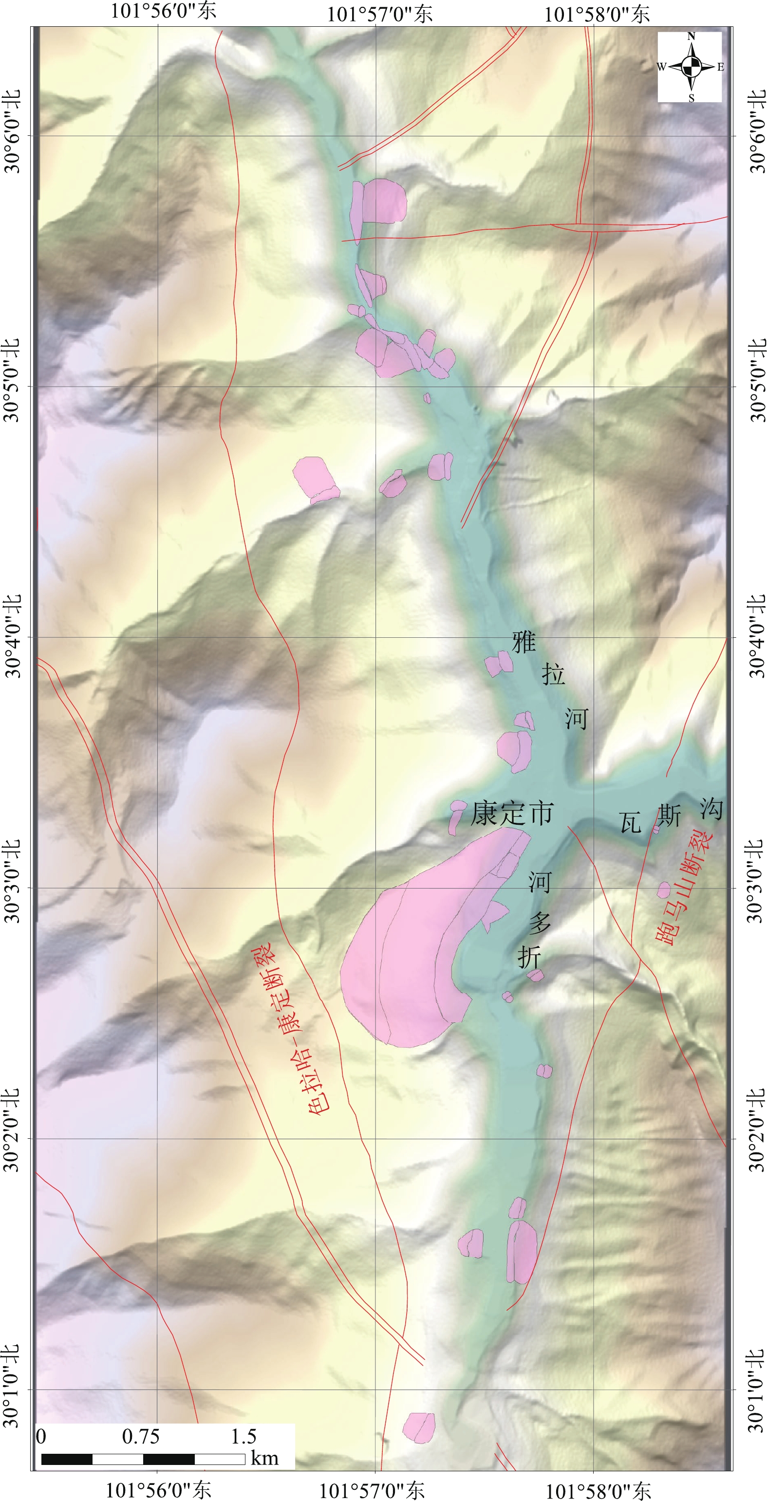
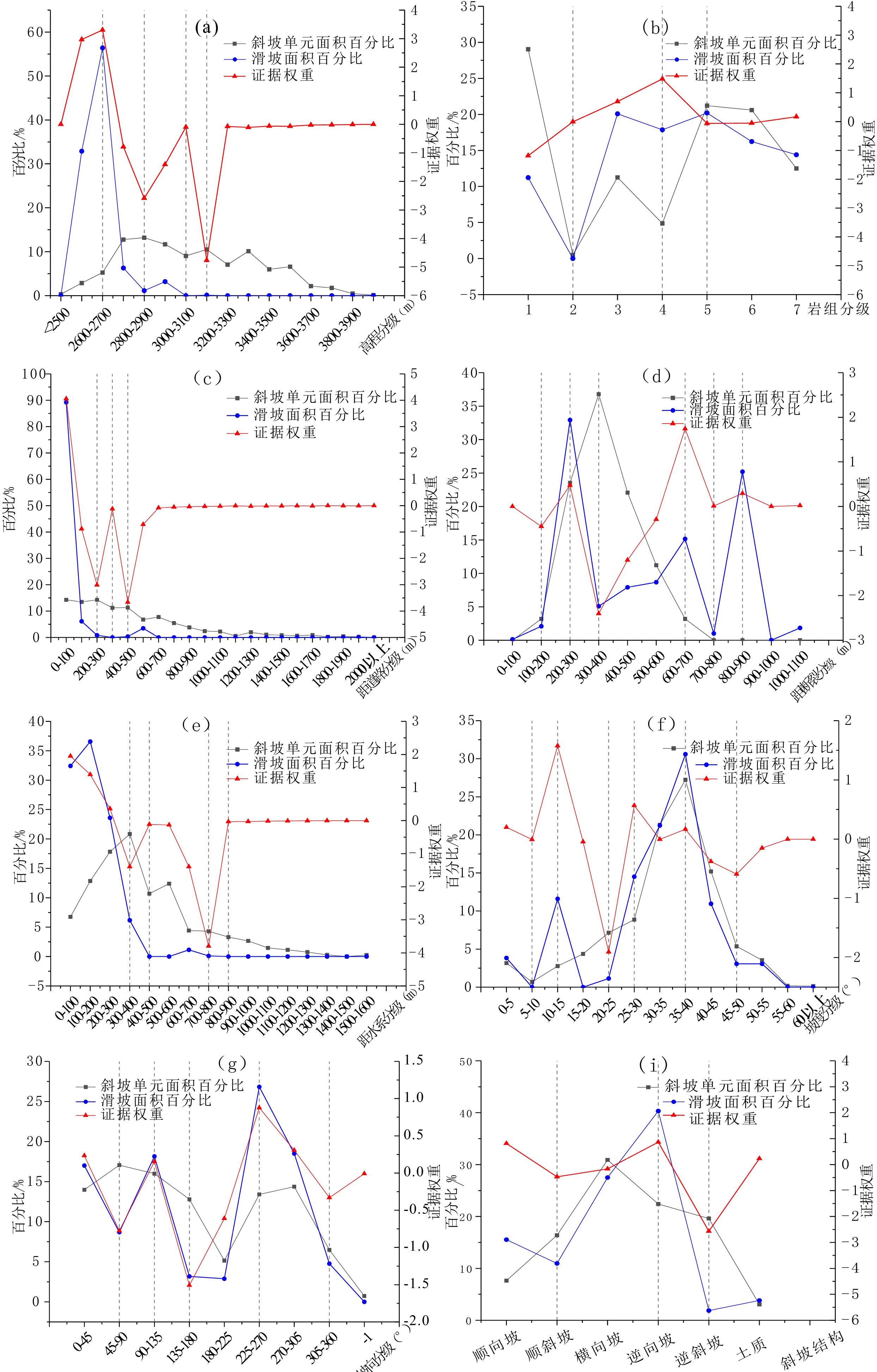
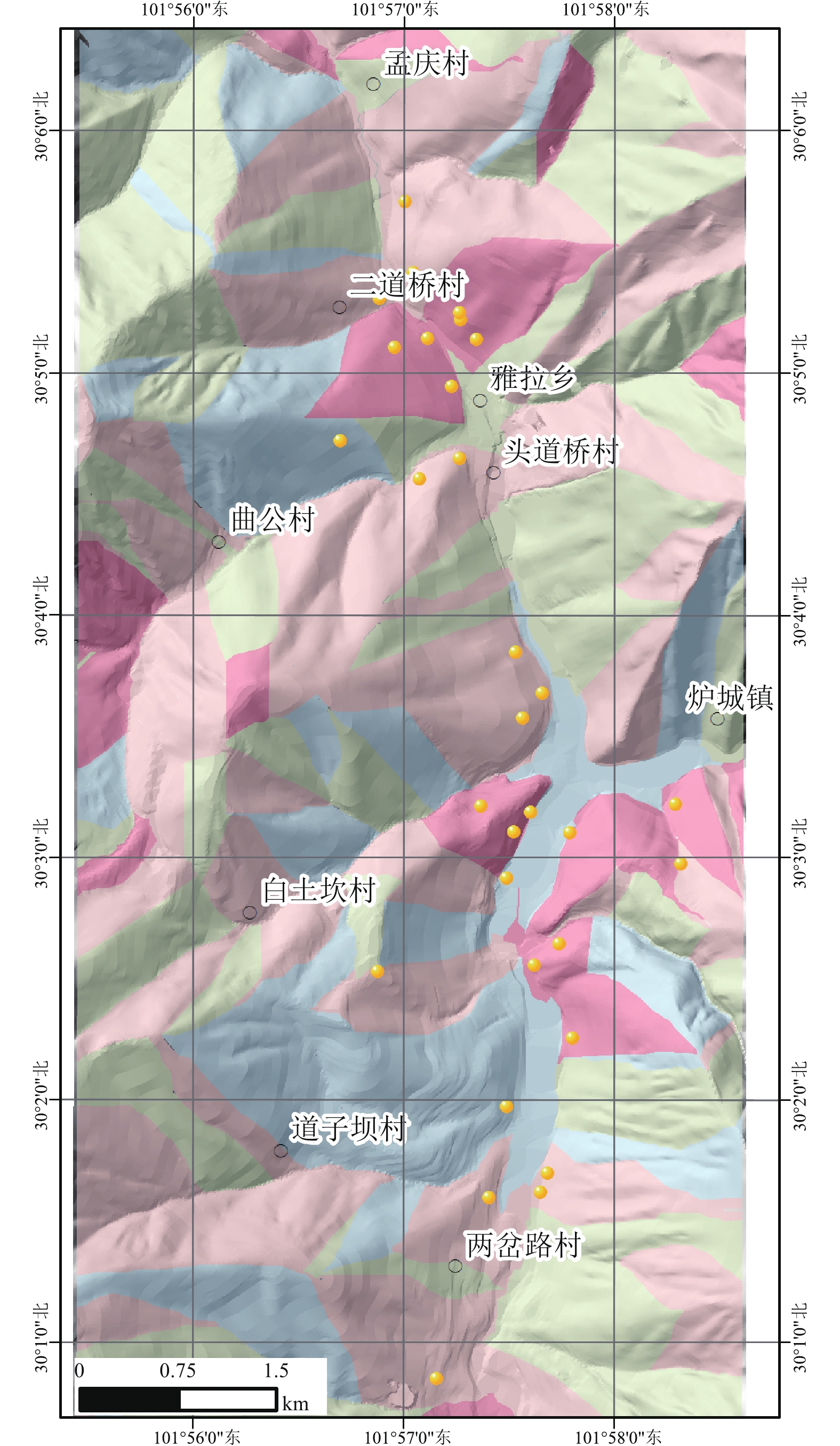
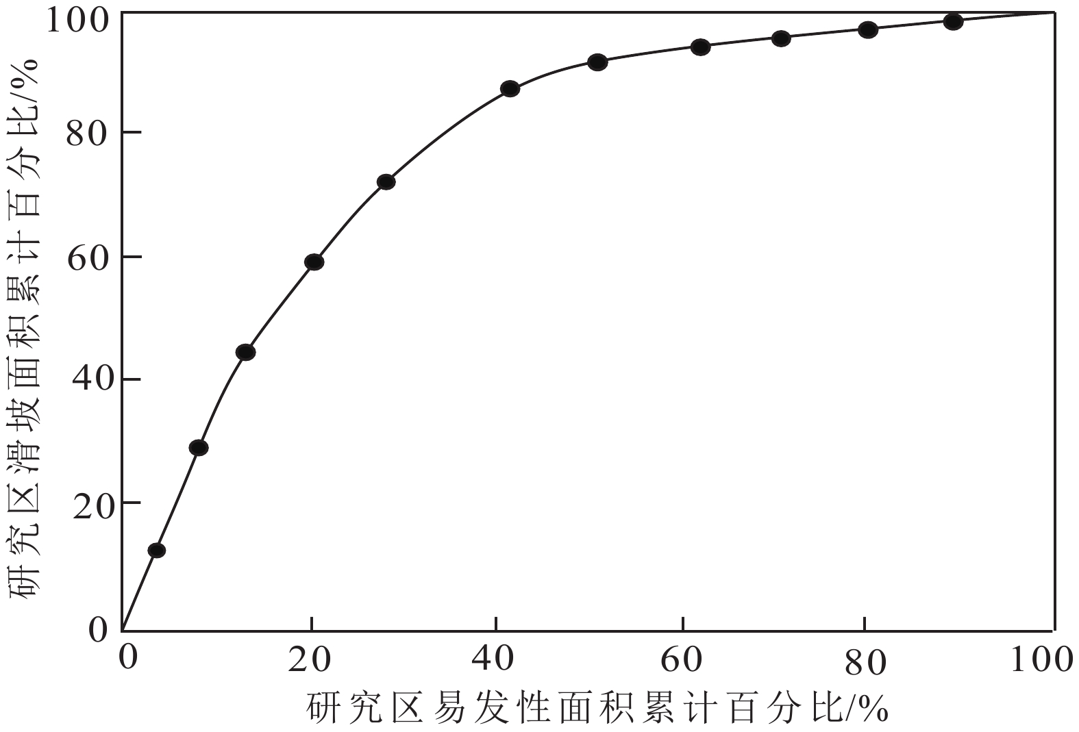
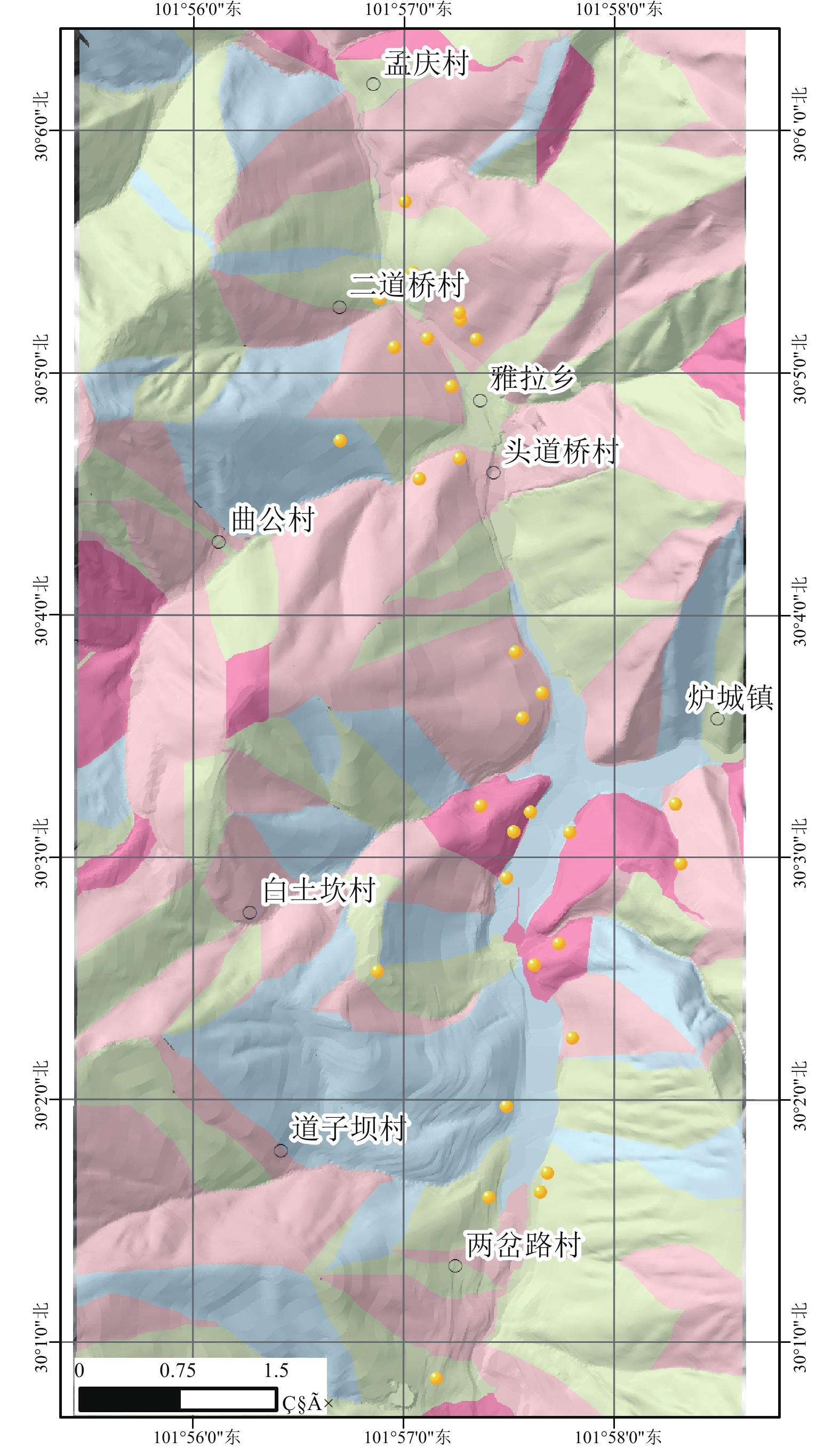
山区地质灾害易发性评价对城镇地质灾害风险管理具有重要意义。本文以康定市为例,以斜坡单元为最小评价单元,选取高程、坡度、坡向、曲率、工程地质岩组、距道路距离、距断裂距离、距水系距离和斜坡结构等9个滑坡影响因子,根据各因子滑坡面积比曲线与证据权值曲线的突变点,划分滑坡影响因子二级状态,并对各影响因子进行相关性分析,剔除相关性较高的距道路距离因子,在此基础上,采用证据权模型进行滑坡易发性评价。对已有治理工程的斜坡单元,本文尝试利用折减系数法对其易发性进行进一步评价。结合现场调查,将研究区滑坡易发性程度划分为:极高易发、高易发、中等易发、低易发。评价结果表明,自然工况下极高易发区主要位于康定市炉城镇以及研究区北侧二道桥村一带,高易发区主要位于雅拉河、折多河与瓦斯沟河谷两侧,对治理工程所在的斜坡单元进行折减后,极高易发区面积由11.21%降至8.42%,滑坡比率由4.03降低至2.3,研究结果符合实际情况,模型精度达77.8%。评价结果较好地反映了康定市区的滑坡易发性分布情况,可为城镇精细化评价提供一定的参考依据。
Abstract:Susceptibility assessment of geological hazard in mountainous areas plays an important role in geological hazard risk management. Taking Kangding city as the example, nine index factors including elevation, gradient, slope aspect, curvature, engineering geological information, distance to road, distance to rivers, distance to fault zones, and the direction and structure of slope were selected as the evaluation indexes based on slope unit. The critical values were selected from the catastrophe points of the landslide ratio curve and weight of evidence curve to determine the factor states on dividing the entire factors interval and the distance to road was removed because of correlation analysis for each influencing factor. Based on the weight of evidence, the Susceptibility assessment was developed. The method of reduction coefficient was used to evaluate the susceptibility accurately for slope units that already had treatment projects. Combine with field investigation results, the study area was classified into four zones with different levels of landslide susceptibility: landslide extremely high-prone area, landslide high-prone area, landslide moderate-prone area, and landslide low-prone area. The results show that extremely high-prone area were mainly distributed in the Lucheng Town of Kangding City and Erdaqiao village in the north. Meanwhile, high-prone areas were mainly distributed on the side of Yala River, Zheduo River, and Wasi Valley. After the reduction of the slope unit where the treatment projects are located, the area and landslide ratio of extremely high-prone areas decreased from 11.21% to 8.42% and from 4.03 to 2.3 respectively. The research results were in good agreement with the distribution of known landslides, and the accuracy of the assessment is about 77.8%. The landslide susceptibility assessment results obtained in this paper reflect the distribution of landslides in the study area, providing technical support for the refined risk assessment of mountainous cities and towns.
-
Key words:
- Susceptibility /
- slope units /
- weight of evidence /
- treatment projects /
- mountainous cities and towns
-

-
表 1 研究区工程地质岩组划分表
Table 1. Classification of engineering geological rock group
岩组编号 工程地质岩组 岩组1 坚硬块状中酸性岩浆岩岩组 岩组2 坚硬块状基性–超基性岩浆岩岩组 岩组3 冰川、冰水、冲洪积、泥石流堆积松散-半胶结土类 岩组4 较软薄–中厚层状砂质泥岩、粉砂岩为主的岩组 岩组5 较软-较硬薄层状砂质板岩、变质砂岩、变质粉砂岩为主的岩组 岩组6 较软薄层状千枚岩、片岩、砂质泥岩为主的岩组 岩组7 坚硬的中厚层状石英岩、大理岩为主的岩组  下载: 导出CSV
表 2 评价指标相关系数
Table 2. The correlation coefficients of assessment index
指标因素 高程 坡度 坡向 曲率 工程地质岩组 距断裂距离 距水系距离 距道路距离 斜坡结构 高程 1 坡度 0.14 1 坡向 0.11 0.07 1 曲率 0.03 0.01 0.00 1 工程地质岩组 −0.28 0.09 0.04 0.00 1 距断裂距离 0.20 0.02 0.03 0.00 −0.06 1 距水系距离 0.23 0.03 −0.04 0.00 −0.14 0.15 1 距道路距离 0.37 0.14 0.11 0.00 −0.23 0.26 0.31 1 斜坡结构 −0.05 −0.16 0.16 0.00 0.09 −0.03 −0.24 −0.11 1
下载: 导出CSV
表 3 各评价指标证据权重
Table 3. The weighted of evidence values of assessment index
评价指标 取值 证据权重 评价指标 取值 证据权重 高程 2490 ~2700 6.267 距断裂距离 0~200 −0.446 2700 ~2900 −3.375 200~300 0.474 2900 ~3100 −1.502 300~400 −2.404 3100 ~3200 −4.761 400~700 0.252 3200 以上−0.361 700~800 0.01 坡度 0~10 0.387 距水系距离 800~900 0.292 10~15 1.574 >900 0.019 15~25 −1.951 0~400 2.299 25~30 0.565 400~500 −0.115 30~40 0.162 500~800 −5.325 40~50 −0.972 800~900 −0.034 50以上 −0.154 900~ 1600 −0.067 坡向 −1 −0.008 斜坡结构 顺向坡 0.813 0-90 −0.543 顺斜坡 −0.471 90~135 0.154 横向坡 −0.166 135~180 −1.508 逆向坡 0.863 180~270 0.268 逆斜坡 −2.572 270~360 −0.024 土质 0.233 工程地质岩组 岩组1 −1.185 曲率 凸 1.082 岩组2 −0.005 凹 −1.386 岩组3 0.696 平 1.786 岩组4 1.483 岩组5 −0.063 岩组6 −0.054 岩组7 0.166307
下载: 导出CSV
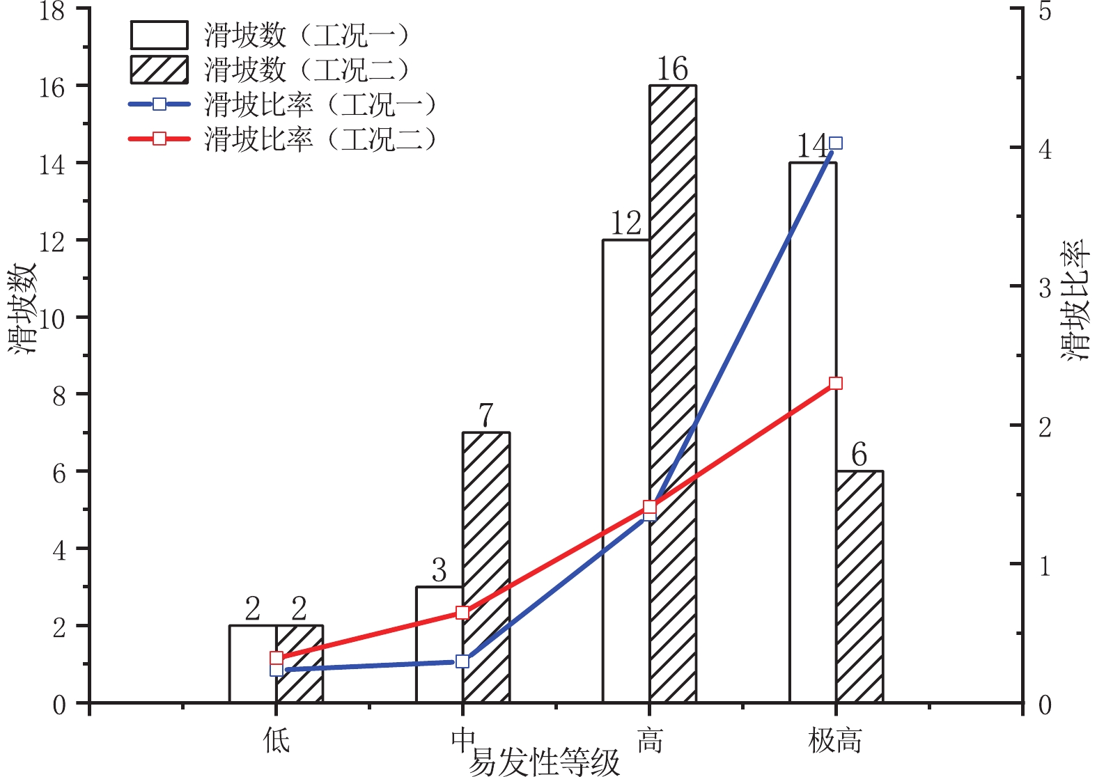
表 4 天然工况斜坡单元统计表
Table 4. The statistical table of natural condition of slope unit
易发性等级 发生滑坡数 斜坡单元面积/m 占总滑坡的比例/% 占斜坡单元的比例/% 滑坡比率 低 2 15.89 6.45 27.24 0.24 中 3 19.21 9.68 32.93 0.29 高 12 16.7 38.71 28.62 1.35 极高 14 6.54 45.16 11.21 4.03
下载: 导出CSV
表 5 工程治理工况斜坡单元统计表
Table 5. The statistical table of treatment project for slope unit
易发性等级 发生滑坡数 斜坡单元面积/m 占总滑坡的比例/% 占斜坡单元的比例/% 滑坡比率 低 2 11.73 6.45 20.11 0.32 中 7 20.34 22.58 34.86 0.65 高 16 21.37 51.61 36.62 1.41 极高 6 4.91 19.35 8.42 2.30
下载: 导出CSV
-
[1] Agterberg F P, Cheng Q, 2002. Conditional Independence Test for Weights-of-Evidence Modeling[J]. Natural Resources Research, 11(4): 249-255. doi: 10.1023/A:1021193827501
[2] 陈绪钰, 李明辉, 王德伟等, 2019. 基于GIS和信息量法的四川峨眉山市地质灾害易发性定量评价[J]. 沉积与特提斯地质, 39(4): 100-112 doi: 10.3969/j.issn.1009-3850.2019.04.011
Chen X Y, Li M H, Wang D W, et al, 2019. Quantitative evalution of geohazards susceptibility based on GIS and information value model for Emeishan City, Sichuan[J]. Sedimentary Geology and Tethyan Geology, 39(4): 100-112. doi: 10.3969/j.issn.1009-3850.2019.04.011
[3] 范强, 巨能攀, 向喜琼等, 2015. 证据权法在滑坡易发性分区中的应用——以贵州桐梓河流域为例[J]. 灾害学, 30(1): 124-129 doi: 10.3969/j.issn.1000-811X.2015.01.024
Fan Q, Ju N P, Xiang X Q, et al, 2015. Application of weights of evidence method in landslide susceptibility zoning-a case study on Tongzi river basin in Guizhou[J]. Journal of Catastrophology, 30(1): 124-129. doi: 10.3969/j.issn.1000-811X.2015.01.024
[4] Goyes-Peñafiel P, Hernández-Rojas A, 2021. Landslide susceptibility index based on the integration of logistic regression and weights of evidence: A case study in Popayan, Colombia[J]. Engineering Geology, 280: 105958. doi: 10.1016/j.enggeo.2020.105958
[5] 黄润秋, 2007.20世纪以来中国的大型滑坡及其发生机制[J]. 岩石力学与工程学报, 26(3): 433-454 doi: 10.3321/j.issn:1000-6915.2007.03.001
Huang R Q, 2007. Large-scale landslides and their sliding mechanisms in China since the 20th century [J]. Chinese Journal of Rock Mechanics and Engineering, 26(3): 433-454. doi: 10.3321/j.issn:1000-6915.2007.03.001
[6] 姜云, 尹金平, 1992. 华蓥山溪口滑坡—碎屑流[J]. 地质灾害与环境保护, 3(2): 51-58
Jiang Y, Yin J P, 1992. Xikou landslide-debris flow, Huaying Mountain [J]. Geological Hazards and Environment Preservation, 3(2): 51-58.
[7] Kumar R, Anbalagan R, 2019. Landslide susceptibility mapping of the Tehri reservoir rim area using the weights of evidence method[J]. Journal of Earth System Science, 128(6): 153. doi: 10.1007/s12040-019-1159-9
[8] 李媛, 孟晖, 董颖等, 2004. 中国地质灾害类型及其特征——基于全国县市地质灾害调查成果分析[J]. 中国地质灾害与防治学报, 15(2): 32-37 doi: 10.16031/j.cnki.issn.1003-8035.2004.02.005
Li Y, Meng H, Dong Y, et al, 2004. Main types and characteristics of geo-hazard in china-based on the results of geo-hazard survey in 290 counties [J]. The Chinese Journal of Geological Hazard and Control, 15(2): 32-37. doi: 10.16031/j.cnki.issn.1003-8035.2004.02.005
[9] Mohammady M, Pourghasemi H R, Amiri M, 2019. Assessment of land subsidence susceptibility in Semnan plain (Iran): a comparison of support vector machine and weights of evidence data mining algorithms[J]. Natural Hazards, 99(2): 951-971. doi: 10.1007/s11069-019-03785-z
[10] Segoni S, Tofani V, Lagomarsino D, et al, 2016. Landslide susceptibility of the Prato-Pistoia-Lucca provinces, Tuscany, Italy[J]. Journal of Maps, 12(sup1): 401-406. doi: 10.1080/17445647.2016.1233463
[11] 唐然, 2007. 监测技术及其在滑坡防治过程中的应用研究——以丹巴县城建设街后山滑坡为例[D]. 成都理工大学.
Tang R, 2007. Research on monitoring technology with the application to landslide control−taking Danba landslide for example[D]. Chengdu University of technology.
[12] 田述军, 张珊珊, 唐青松等, 2019. 基于不同评价单元的滑坡易发性评价对比研究[J]. 自然灾害学报, 28(6): 137-145
Tian S J, Zhang S S, Tang Q S, et al, 2019. Comparative study of landslide susceptibility assessment based on different evaluation units [J]. Journal of Natural Disasters, 28(6): 137-145.
[13] 王德伟, 丁俊, 魏伦武等, 2006. 四川康定城地质灾害易发分区评价[J]. 沉积与特提斯地质, 26(2): 92-95
Wang D W, Ding J, Wei L W, et al, 2006. Risk assessment of geological hazards in Kangding county town western Sichuan [J]. Sedimentary Geology and Tethyan Geology, 26(2): 92-95.
[14] 王佳佳, 殷坤龙, 肖莉丽, 2014. 基于GIS和信息量的滑坡灾害易发性评价——以三峡库区万州区为例[J]. 岩石力学与工程学报, 33(4): 797-808 doi: 10.13722/j.cnki.jrme.2014.04.012
Wang J J, Yin K L, Xiao L L, 2014. Landslide susceptibility assessment based on GIS and weighted information value: a case study of Wanzhou district, three gorges reservoir[J]. Chinese Journal of Rock Mechanics and Engineering, 33(4): 797-808. doi: 10.13722/j.cnki.jrme.2014.04.012
[15] 王建锋, 李世海, 燕琳等, 2002. 重庆武隆“五一”滑坡成因分析[J]. 中国工程科学, 4(4): 22-28 doi: 10.3969/j.issn.1009-1742.2002.04.004
Wang J F, Li S H, Yan L, et al, 2002. Preliminary Analysis on the May1st Landslide at Wulong [J]. Engineering Science, 4(4): 22-28. doi: 10.3969/j.issn.1009-1742.2002.04.004
[16] 王永利, 丁俊, 王德伟等, 2006. 四川康定城地质灾害社会经济易损性分区评价[J]. 沉积与特提斯地质, 26 (2): 88-91 doi: 10.3969/j.issn.1009-3850.2006.02.017
Wang Y L, Ding J, Wang D W, 2006. Assessment of the vulnerability of social economy by geological hazards in Kangding county town western Sichuan [J]. Sedimentary Geology and Tethyan Geology, 26 (2): 88-91. doi: 10.3969/j.issn.1009-3850.2006.02.017
[17] 魏伦武, 王德伟, 丁俊等, 2006. 四川康定城地质灾害危险性分区评价[J]. 沉积与特提斯地质, 26 (2): 81-87
Wei L W, Wang D W, Ding J, et al, 2006. Risk assessment of geological hazards in Kangding county town western Sichuan[J]. Sedimentary Geology and Tethyan Geology, 26 (2): 81-87.
[18] Xiao T, Segoni S, Chen L, et al, 2020. A step beyond landslide susceptibility maps: a simple method to investigate and explain the different outcomes obtained by different approaches[J]. Landslides, 17(3): 627-640. doi: 10.1007/s10346-019-01299-0
[19] 许冲, 戴福初, 姚鑫等, 2009. GIS支持下基于层次分析法的汶川地震区滑坡易发性评价[J]. 岩石力学与工程学报, 28(S2): 3978-3985
Xu C, Dai F C, Yao X, et al, 2009. GIS-based landslide susceptibility assessment using analytical hierarchy process in Wenchuan earthquake region [J]. Chinese Journal of Rock Mechanics and Engineering, 28(S2): 3978-3985.
[20] 殷跃平, 2001. 重庆武隆“5.1”滑坡简介[J]. 中国地质灾害与防治学报, 12 (2): 101
Yin Y P, 2001. A brief introduction to“5.1” landslide in Wulong, Chongqing[J]. The Chinese Journal of Geological Hazard and Control, 12 (2): 101.
[21] 殷跃平, 2013. 加强城镇化进程中地质灾害防治工作的思考[J]. 中国地质灾害与防治学报, 24(4): 5-8
Yin Y P, 2013. On strengthening the prevention and control of geological disasters in the process of Urbanization[J]. The Chinese Journal of Geological Hazard and Control, 24(4): 5-8.
[22] 张茂省, 薛强, 贾俊等, 2019. 山区城镇地质灾害调查与风险评价方法及实践[J]. 西北地质, 52(2): 125-135
Zhang M S, Xue Q, Jia J, et al, 2019. Method and practices for the investigation and risk assessment of geo-hazards in mountainous town[J]. Northwestern Geology, 52(2): 125-135.
[23] 赵良军, 陈冬花, 李虎等, 2017. 基于二元逻辑回归模型的新疆果子沟滑坡风险区划[J]. 山地学报, 35(2): 203-211
Zhao L J, Chen D H, Li H, et al, 2017. A method to assess landslide susceptibility by using logistic regression model for Guozigou region, Xinjiang[J]. Mountain Research, 35(2): 203-211.
[24] 郑万模, 巴仁基, 刘宇杰等, 2012. 四川康定城市地震地质及地质灾害风险评价[J]. 沉积与特提斯地质, 32(3): 75-78
Zheng W M, Ba R J, Liu Y J, et al, 2012. Risk evaluation of urban seismogeology and geological hazards in Kangding, western Sichuan[J]. Sedimentary Geology and Tethyan Geology, 32(3): 75-78.
-
图(7)
表(5)
计量
- 文章访问数: 2950
- PDF下载数: 436
- 施引文献: 0