

Experience and enlightenment of cooperation in bedrock mapping and threedimensional geological modelling with Saskatchewan Geological Survey, Canada
-
摘要:
区域地质填图工作向三维地质调查和建模发展是各国地质调查机构关心的热点,为此中国地质调查局与加拿大萨斯喀彻温省地质调查局开展了为期3年的三维地质调查技术交流合作。基于加拿大萨省北部前寒武纪地区的实地填图工作和三维地质建模技术交流,详细介绍了加方从项目部署、资料收集、野外工作、成果表达等进行基岩地质填图的工作方法和在此基础上开展三维地质建模的技术要点。萨省地质调查局以问题和需求为导向开展填图工作,在人员安排、数据管理和软件平台建设方面充分考虑地质填图-三维建模的连贯性,注重信息公开共享以服务社会,相关经验值得学习借鉴。
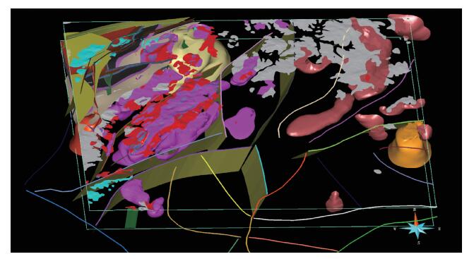
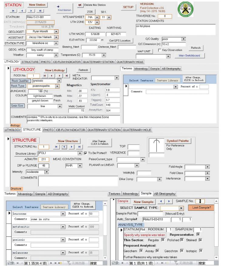
Abstract:The development of regional geological mapping to three-dimensional geological survey and modelling is an issue of great concern to the geological surveys worldwide. Therefore China Geological Survey (CGS) and Saskatchewan Geological Survey (SGS) have carried out a 3-year cooperation in 3-D geological survey. Based on the field bedrock mapping work in the Precambrian area of northern Saskatchewan and the exchange of 3-D geological modelling techniques, the paper introduces the complete process from project arrangement, data compilation, fieldwork and cartographic representation in regard to bedrock mapping, and also the procedures and techniques of 3-D geological modelling. Saskatchewan Geological Survey carries out their geological mapping aiming at key geological problems and meeting social demands, takes full account of consistency of developing from geological mapping to 3-D modelling in personnel organization, data management and software platform construction, and pays particular attention on information sharing to serve the public. All of these experiences are worth learning for us.
-
Key words:
- bedrock mapping /
- three-dimensional geological modelling /
- Canada /
- Saskatchewan
-

-
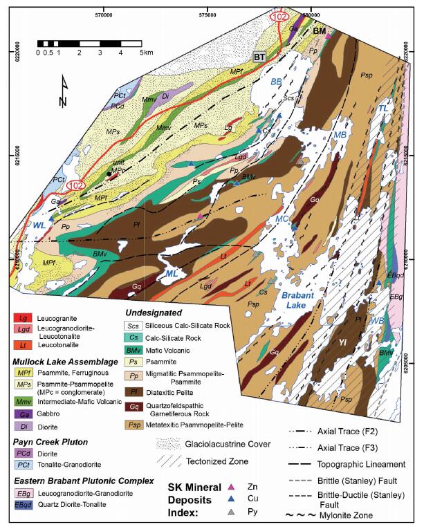
[1] Morelli R M, Zhang Y, Bachynski R D. Geological character and economic mineral potential of the reindeer zone in the brabant lake area[C]//Summary of Investigations 2015, Volume 2. Saskatchewan Geological Survey, Saskatchewan Ministry of the Economy, Miscellaneous Report 2015-4. 2, A-9: 1-21.
[2] Morelli R M, Bachynski R, Zhang Y. Bedrock geology of the Brabant Lake area (parts of NTS 64D/04 and 63M/13): 1: 20000-scale preliminary map 2015-4. 2-(1)[C]//Summary of Investigations 2015, Volume 2. Saskatchewan Geological Survey, Saskatchewan Ministry of the Economy, Miscellaneous Report, 2015-4. 2.
[3] Morelli R M, Zhang Y, Lamming J L. Characterization of the Wappasini and Kyaska thrust sheets in the eastern Brabant Lake-western Wapiskau River area of the western reindeer zone[C]//Summary of Investigations 2016, Volume 2. Saskatchewan Geological Survey, Saskatchewan Ministry of the Economy, Miscellaneous Report 2016-4. 2, A-2: 1-17.
[4] Morelli R M, Lamming J L, Zhang Y. Bedrock geology of the eastern brabant lake-lavender lake areas (parts of NTS 64D/03 and/04, 63M/13 and/14): 1: 20000-scale preliminary map 2016-4. 2-(1)[C]//Summary of Investigations 2016, Volume 2. Saskatchewan Geological Survey, Saskatchewan Ministry of the Economy, Miscellaneous Report, 2016-4. 2.
[5] Geological Survey of Canada. Natural resources canada. geoscience data repository for geophysical data[EB/OL](2016-05-15)[2018-01-01]http://gdr.agg.nrcan.gc.ca/gdrdap/dap/search-eng.php#2016. .
[6] Saskatchewan Geological Survey. Saskatchewan ministry of the economy geological atlas of saskatchewan[EB/OL] (2017-12-24)[2018-01-01]https://gisappl.saskatchewan.ca/GeoAtlas/.2017.
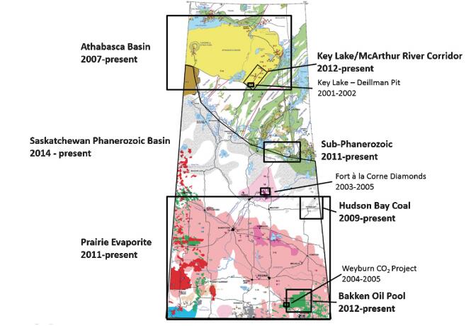
[7] Harvey S E. Fort a la Corne Kimberlite 3-D model (NTS 73H07)[EB/OL](2014-01-31)[2018-01-01]http://publications.gov.sk.ca/details.cfm?p=83202. 2014.
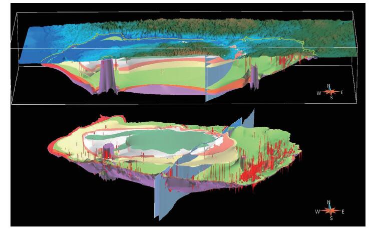
[8] Bosman S A, Card C D, Gouthas G, et al. Athabasca Basin 3-D model (NTS 64E, 63L, 63M, and 74E to 74P)[EB/OL] (2014-03-18)[2018-01-01]http://publications.gov.sk.ca/details.cfm?p=83201.2014.
[9] Card C D, Delaney G, Bosman S A, et al. Modelling the 3D Architecture of Rocks and Structures of the Athabasca Basin: How Saskatchewan is Tackling the Challenge from Down Under[C]//GeoCanada 2010-Working with the Earth, Conference Abstracts. 2010.
[10] Morelli R M. Regional Data Compilation and Three-Dimensional Geological Modelling in the Vicinity of the Shield Margin, Hanson Lake Area[C]//Summary of Investigations 2012, Volume 2. Saskatchewan Geological Survey, Saskatchewan Ministry of the Economy, Miscellaneous Report 2012-4. 2, A-8: 1-12.
[11] Morelli R M, Maxeiner R O. Geochemical Data Compilation of the Hanson Lake Assemblage and Sub-Phanerozoic Extensions: Proposed Implications for Tectonic Setting and Volcanogenic Massive Sulphide Mineralization[C]//Saskatchewan Geological Survey, Saskatchewan Ministry of the Economy, Open File Report 2013-2: 1-25.
[12] 王涛, 计文化, 胡建民, 等.专题地质填图及有关问题讨论[J].地质通报, 2016, 35(5):633-641. http://dzhtb.cgs.cn/ch/reader/view_abstract.aspx?file_no=20160501&flag=1
-
 下载:
下载:

图(7)
计量
- 文章访问数: 709
- PDF下载数: 7
- 施引文献: 0