

DEMONSTRATION APPLICATION OF BEIDOU SATELLITE TECHNOLOGY IN DETAILED GEOLOGICAL DISASTER INVESTIGATION IN YUSHU, QINGHAI PROVINCE
-
摘要:
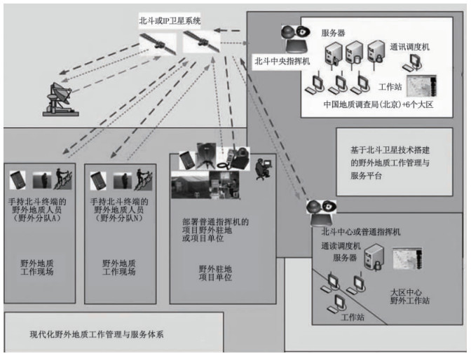
利用北斗卫星系统的定位通讯功能,结合IP卫星技术、网络技术和网格技术,构建现代化野外地质工作管理与服务体系,实现了野外地质调查人员-野外驻地-野外工作站-大区中心站-北京中心站五级互联互通,项目管理部门可随时查看野外地质调查人员的工作轨迹,获知野外工作进展,提供突发事件应急处置远程服务。该系统在青海玉树州地质灾害详查项目中示范应用效果良好。
Abstract:Based on the positioning and communication of Beidou Navigation Satelliate System, which combines IP satellite technology, network and grid technology, the modern field geological work management and service mode are established to realize the information interconnection and interflow between the investigator in-field, investigator in-residence, field station, regional center of investigator and China Geological Survey. The department of project management may inspect the work of investigator in the field, get the work progress in the field, and provide remote service of emergency disposal by internet any time. The demonstrated application revealed very well to the modern field geological work management and service mode in the project of detailed geological disaster survey in Yushu, Qinghai Province.
-

-
[1] 朱永辉, 白征东, 过静珺, 等.基于北斗一号的地质灾害自动监测系统[J].测绘通报, 2010, (2):5~7. http://www.cnki.com.cn/Article/CJFDTOTAL-CHTB201002004.htm
ZHU Yong-hui, BAI Zheng-dong, GUO Jing-jun, et al. A new wireless system for geological disasters monitoring based on Beidou Ⅰ[J]. Bulletin of Surveying and Mapping, 2010, (2):5~7. http://www.cnki.com.cn/Article/CJFDTOTAL-CHTB201002004.htm
-
 下载:
下载:

图(3)
计量
- 文章访问数: 317
- PDF下载数: 2
- 施引文献: 0