

-
摘要:
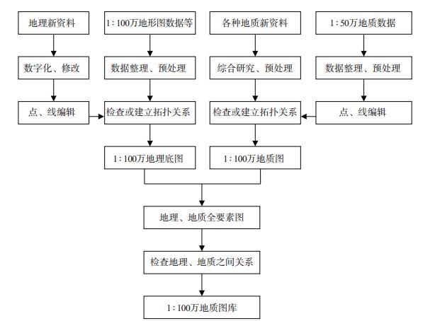
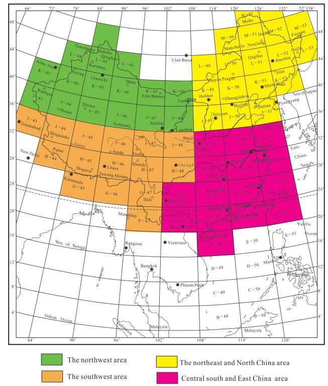
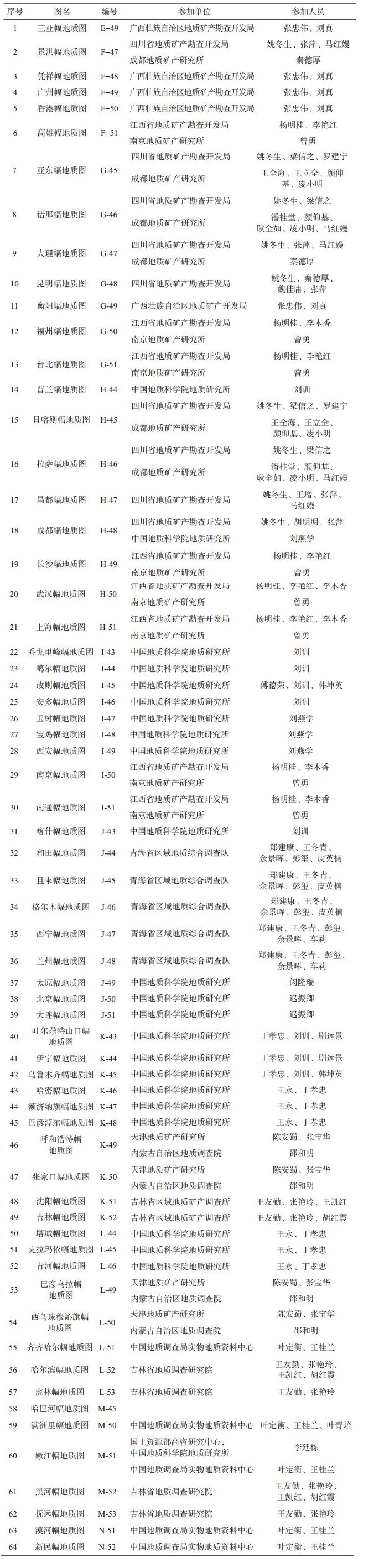
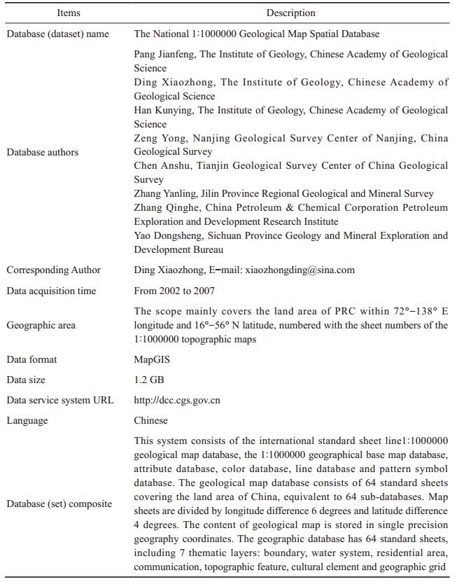
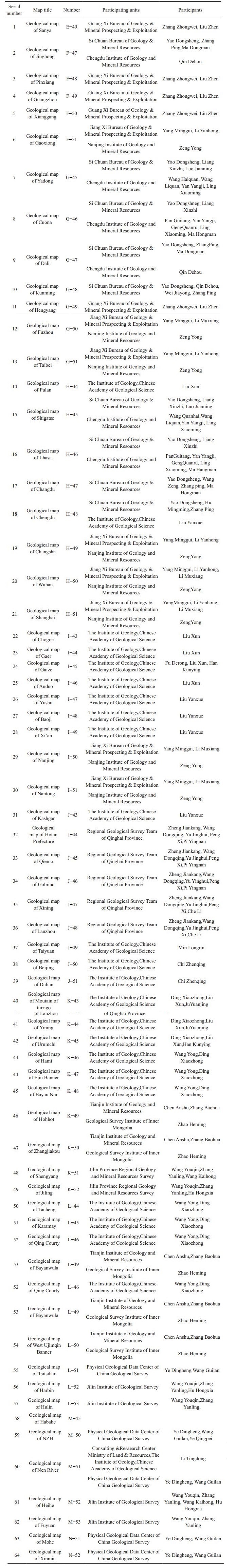
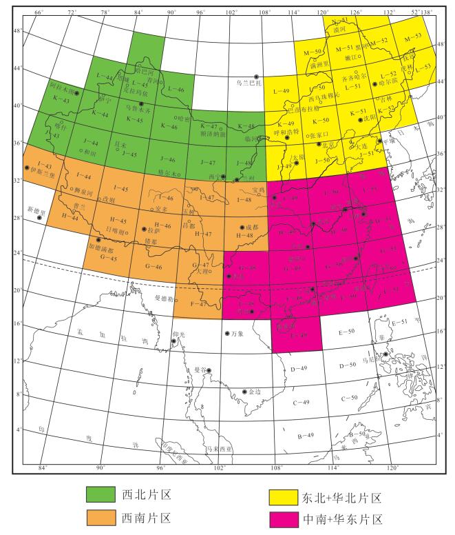
中华人民共和国1:100万数字地质图数据库是根据统一标准和要求编制的专题数字地质图,以中华人民共和国1:50万数字地质图数据库为数据源,在综合研究的基础上,充分吸收近年来地质调查1:25万、1:20万、1:5万等区调工作新成果、新资料,应用地质编图新技术、新理论和新方法编制而成。以年代地层单位为主、辅以岩石地层的表示方法,侵入岩按“岩性加年代”表示方法,进一步提高了基础地质的研究程度。地质图数据库内容丰富,信息量大,数据量约为1.2 GB,标示了岩石地层单位5347个图例,侵入体“岩性加时代”单位1780个图例,跨省区重要断裂93条,各省(市、自治区)内重要断层558条,同位素年龄数据1545个(组),有代表性的钻孔382个。所有地质体的面元及线元、同位素年龄和钻孔都建立了相应的属性,相邻图幅之间进行了接图处理,编写了编图说明书和元数据。数据库采用统一的线型库、符号库、色标库等,成图过程全部采用MapGIS6.5平台计算机辅助成图,成图精度高,质量好,符合设计要求,全国64幅图采用分4个片区的工作方法,最后统一编制而成。该数字地质图是目前中国资料最全、内容最新的1:100万地质图,是中国第一份应用GIS技术的1:100万数字地质图的最新成果,充分反映了中国地质构造特点和当前地质研究的新水平。
-
关键词:
- 1:100万数字地质图 /
- 空间数据库 /
- MapGIS
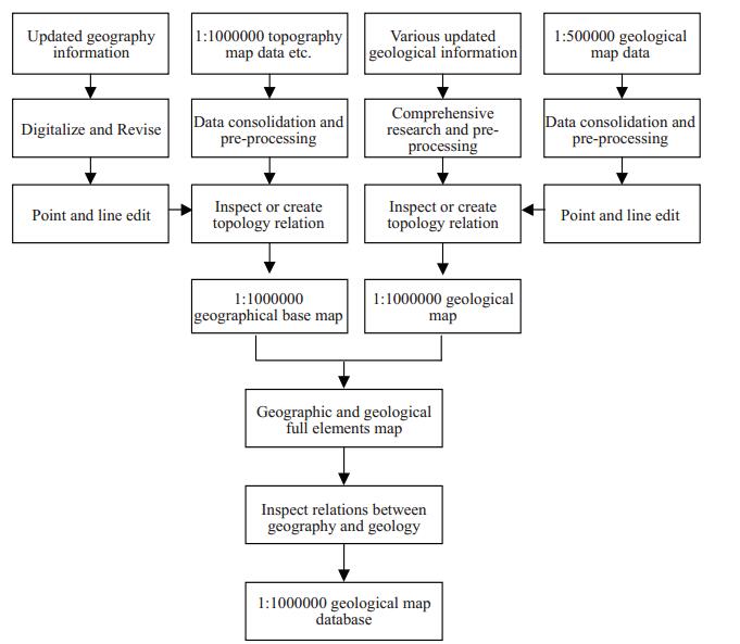
Abstract:The People's Republic of China 1:1000000 digital geological map database is based on uniform standards and requirements for the preparation of a thematic digital geological map. The geological map is based on comprehensive research, and fully absorbs the new achievements and new data of geological survey in recent years, making use of new technology, new theory and new methodology. Based on the chronology of the stratigraphic units and the representations of the rock strata, the intrusive rocks are further represented by the method of "lithology plus dating", which further improves the research degree of basic geology. The geological map database is rich in information with about 1.2 GB, having:rock stratigraphy units 5347 illustrations; intrusion "lithology plus era" unit 1780 cases; inter-provincial important fault 93; 558 important faults in the provinces (autonomous regions and municipalities); 1545 (group) of isotopic age data; and 382 representative holes. All the geometric elements of surface elements and line elements, isotopic age and drillings have established corresponding attributes, with adjacent maps between the map processing, map instructions and metadata are prepared. The database uses a unified linear library, symbol library, color library, the mapping process all using the MapGIS6.5 platform computer-aided map, plotting high precision, good quality, meeting design requirements to produce 64 national maps with four Area of the work of the method, the final unified system made. The digital geological map is the most complete and the latest 1:1000000 geological map in China, being the first result of China's first such digital geological map using GIS technology, which fully reflects the characteristics of China's geological structure and the current new level of geological research.
-
Key words:
- 1:1000000 digital geological map /
- spatial database /
- MapGIS
-

-
Asch K.Under construction:the geological GIS of the 1:5 000 000 international geological map of Europe and adjacent areas[J].Episodes, 2001, 24(3):201-204. http://www.kgs.ku.edu/Conferences/IAMG//Sessions/I/Papers/asch_p.pdf
Bouysse P, Mendel V, Munschy M, et al.A new CGMW map:The structural map of the Indian Ocean:An attempt at ocean cartography[J].Episodes, 2004, 26(2):199-202. https://www.researchgate.net/publication/253897747_A_new_compilation_of_plate_tectonics_in_the_Indian_Ocean
韩坤英, 丁孝忠, 范本贤, 马丽芳, 剧远景.2005.MapGIS在建立地质图数据库中的应用[J].地球学报, 26(6):587-590. http://www.wanfangdata.com.cn/details/detail.do?_type=perio&id=dzlp2000z1041
韩坤英, 丁孝忠, 范本贤, 耿树方, 剧远景.2005.基于GIS的区域地质编图方法[J].中国地质, 32(4):713-717. http://geochina.cgs.gov.cn/ch/reader/view_abstract.aspx?file_no=20050422&flag=1
李廷栋.2007.国际地质编图现状及发展趋势[J].中国地质, 34(2):206-211. http://geochina.cgs.gov.cn/ch/reader/view_abstract.aspx?file_no=20070202&flag=1
张庆合, 曹邦功, 姜兰.2002.1:50万地质图数据库的研建[J].中国地质, 29(2):208-212. http://geochina.cgs.gov.cn/ch/reader/view_abstract.aspx?file_no=20020219&flag=1
万常选, 廖国琼, 吴京慧, 刘喜平.2009.数据库系统原理与设计[M].北京:清华大学出版社, 1-44.587-590.
李廷栋.2007.国际地质编图现状及发展趋势[J].中国地质, 34(2):206-211. http://geochina.cgs.gov.cn/ch/reader/view_abstract.aspx?file_no=20070202&flag=1
张庆合, 曹邦功, 姜兰.2002.1:50万地质图数据库的研建[J].中国地质, 29(2):208-212. http://www.wanfangdata.com.cn/details/detail.do?_type=perio&id=jldz200702013
Asch K.2001.Under construction:the geological GIS of the 1:5000000 international geological map of Europe and adjacent areas[J].Episodes, 24(3):201-204. http://www.kgs.ku.edu/Conferences/IAMG//Sessions/I/Papers/asch_p.pdf
Bouysse P, Mendel V, Munschy M, Segoufin J.2004.A new CGMW map:The structural map of the Indian Ocean:An attempt at ocean cartography[J].Episodes, 26(2):199-202. https://www.researchgate.net/publication/253897747_A_new_compilation_of_plate_tectonics_in_the_Indian_Ocean
Han Kunying, Ding Xiaozhong, Fan Benxian, Geng Shufang, Ju Yuanjing.2005.The application of MapGIS to the construction of geological map database[J].Acta Geoscientica Sinica, 26(6):587-590(in Chinese with English abstract). http://d.wanfangdata.com.cn/Periodical_dqxb200506017.aspx
Han Kunying, Ding Xiaozhong, Fan Benxian, Geng Shufang, Ju Yuanjing.2005.Methods of regional geological map production based on GIS[J].Geology in China, 32(4):713-717(in Chinese with English abstract). http://geochina.cgs.gov.cn/ch/reader/view_abstract.aspx?file_no=20050422&flag=1
Li Tingdong.2007.Status and development trend of geological map compilation in the world[J].Geology in China, 34(2):26-211(in Chinese with English abstract). http://geochina.cgs.gov.cn/ch/reader/view_abstract.aspx?file_no=20070202&flag=1
Zhang Qinghe, Cao Banggong, Jiang Lan.2002.Development and construction of the 1:500 000 geological map database[J].Geology in China, 29(2):208-212(in Chinese with English abstract). http://geochina.cgs.gov.cn/ch/reader/view_abstract.aspx?file_no=20020219&flag=1
-
 下载:
下载:

图(4)
表(4)
计量
- 文章访问数: 3727
- PDF下载数: 83
- 施引文献: 0