

Database of 1∶50 000 Mineral Geological Survey Results of the Shixia Map-sheet in Yawan–Daqiao Integrated Exploration Area, Gansu Province
-
摘要:
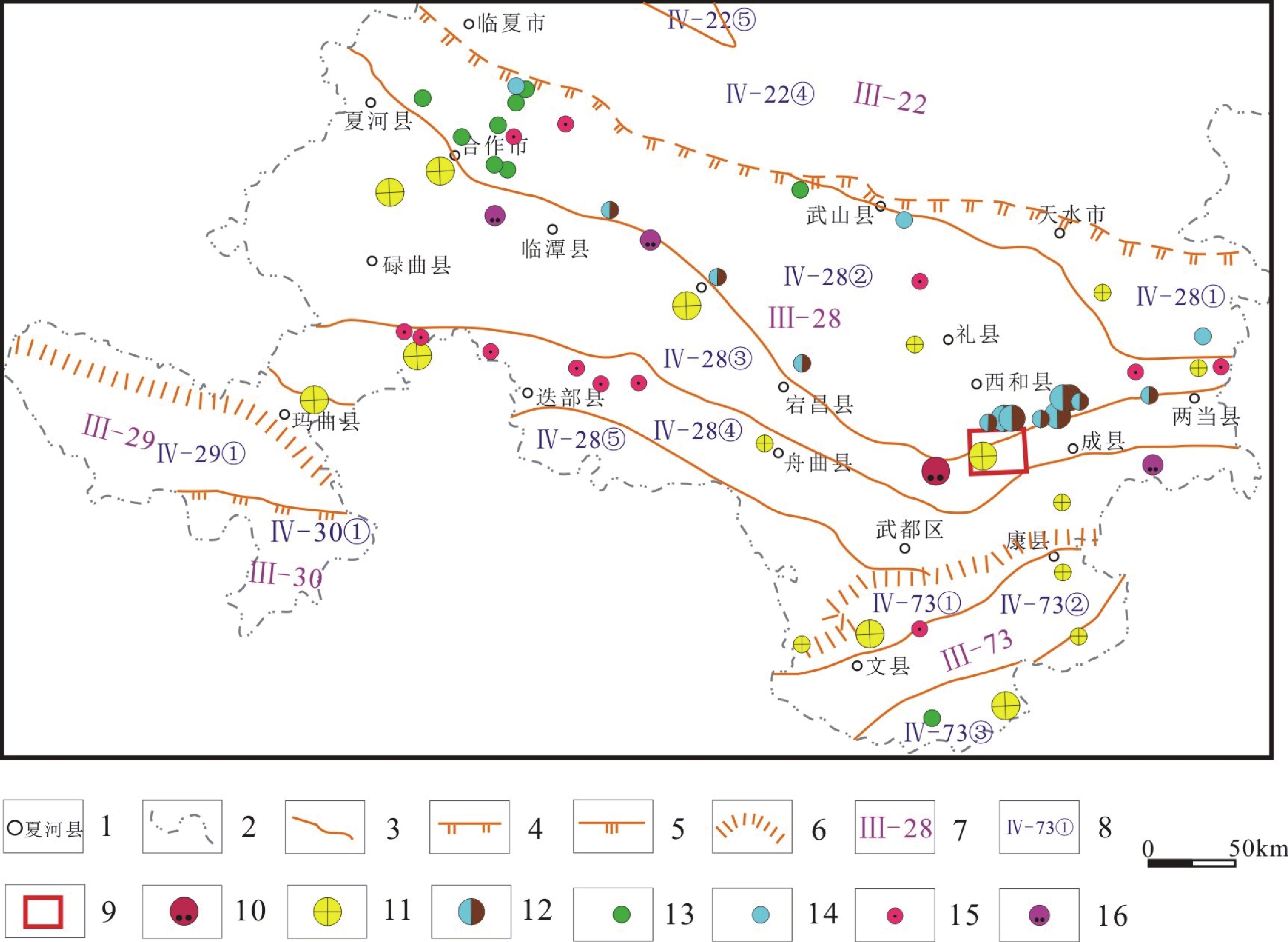
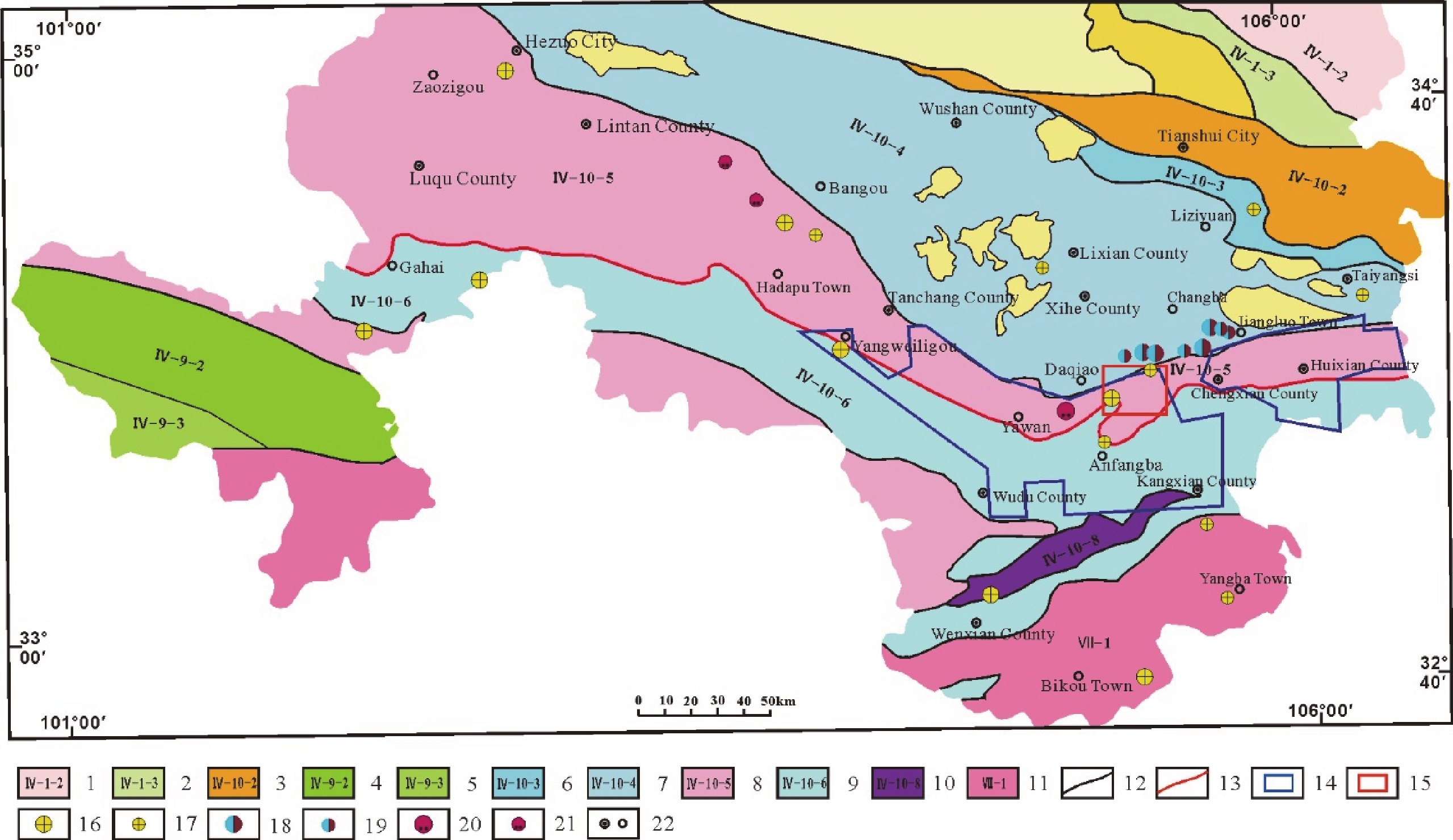
甘肃石峡幅(I48E014014)1∶50 000矿产地质调查按照中国地质调查局《固体矿产地质调查技术要求(1∶50 000)》(DD2019-02), 在系统收集和综合分析已有地质、物探、化探、遥感、矿产等资料基础上, 采用数字填图技术, 开展石峡幅1∶50 000矿产地质专项填图、综合检查、找矿预测和圈定找矿靶区。专项地质填图采用填编结合的方式, 将图幅地层划分为19类非正式沉积建造类型, 划分侵入岩建造类型1个;结合重点工作区矿产综合检查, 填写矿产信息卡片。在此基础上开展典型矿床研究, 总结成矿要素, 完成1∶50 000矿产地质图、成矿规律图、矿产预测图等成果图件编制和数据库建设。成果图件和数据库突出表达了成矿建造、区域构造、矿化蚀变信息;系统总结了石峡幅成矿要素信息, 建立了典型矿床成矿模型;圈定了7处中低温热液型金矿找矿预测靶区。
Abstract:The 1∶50 000 mineral geological survey of Shixia Map-sheet (I48E014014) in Gansu Province was conducted according to the Technical Requirements of Solid Mineral Geological Survey (1∶50 000) (DD2019−02) issued by the China Geological Survey. During this survey, the digital mapping technique was employed to carry out 1∶50 000 mineral geology-specific mapping, comprehensive mineral inspection, and prospecting prediction and to delineate prospecting target areas based on the systematical collection and comprehensive analysis of existing geological, geophysical, geochemical, remote sensing, and mineral data. The geology-specific mapping was completed by field mapping and indoor map compilation. As a result, the Shixia Map-sheet was divided into 19 types of informal sedimentary suites and one type of intrusive rock suites. Meanwhile, the mineral information cards were filled in combination with comprehensive mineral inspection of major survey sites in the Map-sheet area. On these bases, typical deposits in the Map-sheet area were researched and metallogenic factors were summarized. Moreover, the result maps such as 1∶50 000 mineral geological map, metallogenic regularity maps, and mineral prediction maps were prepared, and a database of these maps was developed. In the result maps and database, metallogenic suites, regional structures, and mineralized alteration are highlighted, metallogenic factors in the Shixia Map-sheet are systemically summarized, the metallogenic models of typical deposits are established, and seven prospecting and prediction targets of medium-low temperature hydrothermal gold deposits was delineated.
-

-
表 1 数据库(集)元数据简表
条目 描述 数据库(集)名称 甘肃省石峡幅1∶50 000矿产地质图数据库 数据库(集)作者 宋小兵,甘肃省地质调查院
寇银川,甘肃省地质调查院
闫少波,甘肃省地质调查院
王 伟,甘肃省地质调查院数据时间范围 2018—2019年 地理区域 东经105°15′~105°30′,北纬33°40′~33°50′ 数据格式 *.wl,*.wt,*.wp 数据量 137 MB 数据服务系统网址 http://dcc.cgs.gov.cn 基金项目 中国地质调查局地质调查项目“整装勘查区找矿预测与技术应用示范”子项目“甘肃崖湾−大桥地区金锑矿整装勘查区综合地质调查与潜力评价示范”(121201004000172201–66)资助 语种 中文 数据库(集)组成 该数据库包括1∶50 000矿产地质图、成矿规律图、矿产预测图和系统库Slib组成。
1∶50 000成果图件主要由主图、角图和整饰部分组成。矿产地质图主图主要包括沉积岩建造、侵入岩建造、第四纪、脉岩、构造、地质界线、产状、矿床(点)、蚀变、地质代号、地理信息。角图主要包括沉积岩和侵入岩建造柱状图,脉岩、构造、矿化蚀变图及其图例,图切地质剖面图,大桥典型矿床平面图、典型勘探线剖面图、典型剖面立体图、大桥一带隆滑构造示意图、成矿带位置示意图,矿种及规模图例、矿产地名录。
成矿规律图主图主要包括容矿地层、含矿建造,构造、地质界线、产状、矿床(点)、蚀变、地质代号、地理信息、地球物理、地球化学、遥感信息。角图主要为区域构造格架图、金锑矿成矿模型、成矿区带位置图,区域金成矿要素表,区域锑成矿要素表,成矿构造信息表,成矿谱系表。
矿产预测图主图主要包括含矿建造,构造、地质界线、产状、矿床(点)、地质代号、地理信息,预测找矿靶区。辅图主要为区域成矿模式图,区域中低温热液型金矿、锑矿、钴(金)矿预测要素信息表,新发现矿产地及估算资源量结果,资源储量估算表。成果图件整饰部分主要包括图名、比例尺、接图表、中国地质调查局局徽、图框、坐标参数、责任签等 下载: 导出CSV
表 2 石峡幅矿产地质图产状属性表
序号 数据项目名称 标准编码 数据类型 实例 1 产状要素代码 Feature_Id 字符串 AI48E014014000000858 2 产状要素类型 Feature_Type 字符串 01 3 原始资料代码 Source_Id 字符串 D6008_1 4 产状名称 Attitude_Name 字符串 岩层产状 5 走向 Strike 整数型 95° 6 倾向 Dip 整数型 5° 7 倾角 Dip_Angle 整数型 79°
下载: 导出CSV
表 3 石峡幅矿产地质图建造–构造图层属性表
序号 数据项目名称 标准编码 数据类型 实例 1 地质体面实体代码 Feature_Id 字符串 AI48E014014000000379 2 地质面实体类型 Feature_Type 字符串 02 3 岩石地层单位名称 Geobody_Name 字符串 甘肃群第二岩性段 4 地层时代 Geobody_Era 字符串 N 5 建造大类 Formation 字符串 沉积岩建造 6 建造类型 Metallogenic 字符串 砂砾岩建造 7 岩性组合 Combination 字符串 紫红色含砾砂岩 8 大地构造环境 Structural_Env 字符串 泽库前陆盆地相
下载: 导出CSV
表 4 石峡幅矿产地质图断裂属性表
序号 数据项目名称 标准编码 数据类型 实例 1 断裂要素代码 Feature_Id 字符串 AI48E014014000001721 2 断裂要素类型 Feature_Type 字符串 03 3 断裂代码 Fault_Type 字符串 压扭性断裂 4 断裂名称 Fault_Name 字符串 青岗岭山口—人头山断裂 5 断裂编号 Fault_Code 字符串 F1–1 6 断裂性质 Fault_Character 字符串 逆冲推覆断裂 7 断裂运动方式 Fault_motion 字符串 逆冲推覆 8 断裂上盘地质体代号 Fault_Up_Body 字符串 T2d1 9 断裂下盘地质体代号 Fault_Bottom_Body 字符串 D2h1 10 断裂宽度 Fault_Wide 浮点型 100 11 断裂长度 Fault_Wide 浮点型 24.9 12 断裂走向 Fault_Strike 整数型 60° 13 断裂面倾向 Fault_Dip 整数型 330° 14 断裂面倾角 Fault_Dip_Angle 整数型 70° 15 断距 Fault_Distance 浮点型 1 16 断裂形成时代 Era 字符串 中生代 17 活动期次 Movement_Period 字符串 印支期
下载: 导出CSV
表 5 石峡幅矿产地质图地质界线数据属性表
序号 数据项目名称 标准编码 数据类型 实例 1 地质界线要素标识号 Feature_Id 字符串 AI48E014014000001742 2 地质界线要素类型 Feature_Type 字符串 04 3 地质界线类型 Boundary_Name 字符串 角度不整合 4 界线左侧地质体代号 Left_Boundary_Code 字符串 N1G2 5 界线右侧地质体代号 Right_Boundary_Code 字符串 K1j2
下载: 导出CSV
表 6 石峡幅矿产地质图矿产地属性表
序号 数据项目名称 标准编码 数据类型 实例 1 矿产地要素代码 Feature_Id 字符串 AI48E014014000000003 2 矿产地要素类型 Feature_Type 字符串 05 3 矿种名称 Commodities_Name 字符串 铅锌矿 4 共生矿 Paragenic_Ore 字符串 / 5 伴生矿 Associated_Ore 字符串 银 6 矿产地数 Ore_Sums 整数型 / 7 矿石品位 Ore_Grade 字符串 铅0.5%,锌3.44% 8 规模 Deposite_Size 字符串 中型 9 成矿时代 Metallogenetic_Epoch 字符串 印支期阶段 10 矿产地名 Placename 字符串 甘肃省西和县人头山铅锌矿 11 成因类型 Genesis_Types 字符串 浅成中–低温热液型铅锌矿 12 工业类型 Industrial_Types 字符串 有色金属铅锌矿
下载: 导出CSV
表 7 石峡幅矿产预测图预测靶区属性表
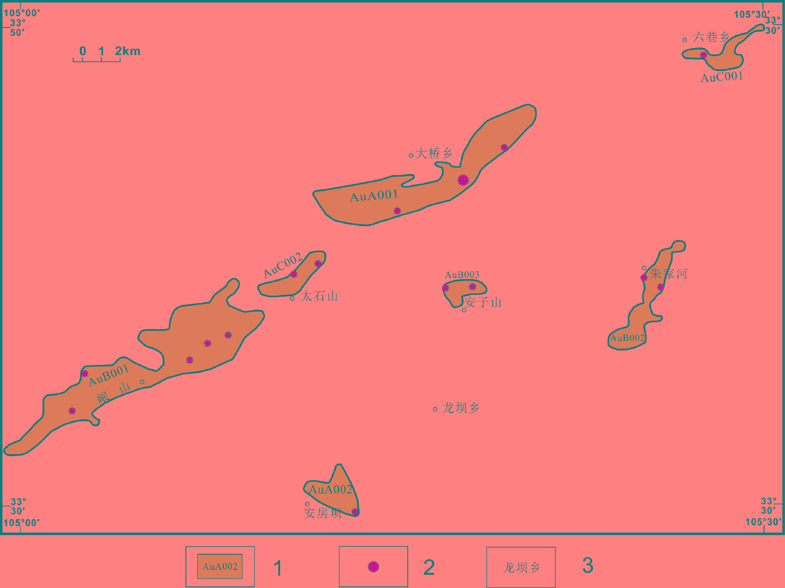
序号 数据项目名称 标准编码 数据类型 实例 1 靶区周长 周长 双精度型 537.6 2 靶区面积 面积 双精度型 6293.48 3 图幅号 MAPCODE 字符串 I48E014014 4 靶区要素代码 FEATURE_ID 字符串 A0000000000000000008 5 靶区要素类型 FEATURE_Type 字符串 06 6 颜色代码 COLOUR 字符串 283 7 靶区名称 TARGET_NAME 整数型 大桥金矿预测区 8 靶区编号 TARGET_CODE 字符串 AuA001 9 靶区面积 QDTCBA 浮点型 21.14 10 地理位置 DLWZ 字符串 甘肃省西和县大桥 11 主矿种 KCCA 字符串 Au 12 典型矿床 DXKC 字符串 大桥金矿 13 已知矿床 DXKE 字符串 大桥金矿、饮马河金矿 14 靶区类别 QDTCBF 字符串 Ⅰ 15 靶区级别 QDTCBT 字符串 A 16 预测资源量 PKCAAG 整数型 160585 17 成矿时代 KCDS 字符串 印支期 18 容矿地层 DDDA 字符串 三叠系滑石关组一段 19 大地构造位置 GZAN 字符串 临潭—两当深大断裂和窑上石峡断裂 20 岩浆类型 YSEA 字符串 中低温热液型 21 地球化学特征 QDHX 字符串 Ag、Au、Hg、Sb、Sn异常套合很好 22 蚀变特征 KCAGA 字符串 硅化、黄铁矿化、碳酸盐化、萤石化
下载: 导出CSV
表 8 沉积岩建造一览表
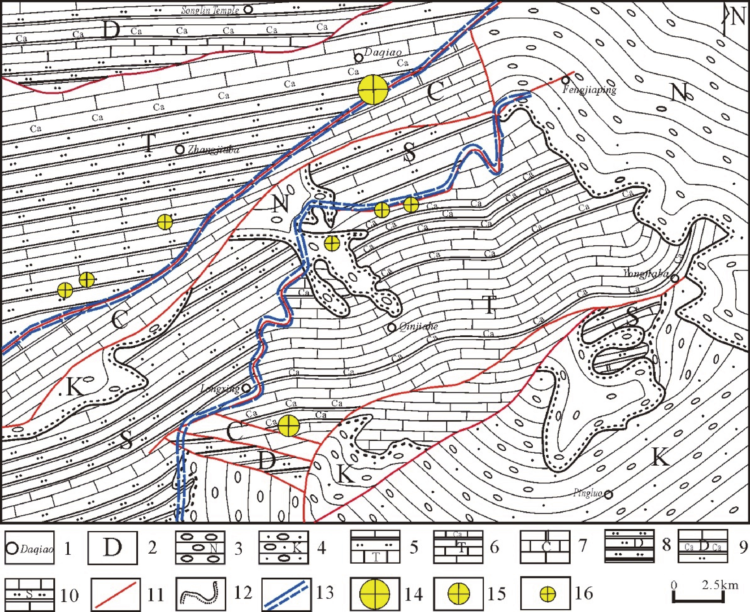
年代地层单元 岩石地层单元 建造单元特征 系 统 组 代号 建造类型 厚度/m 岩性 第四系 全新统 Qhpal 15 冲洪积砂、砂砾石、亚砂土 更新统 Qpeol 5~10 黄土状粉砂质黏土、粉砂土、含砾砂土 新近系 N1Ga 砂砾岩建造 1179 砖红色砂砾岩夹泥质粉砂岩、粉砂质泥岩 白垩系 鸡山组 K1j2a 砂砾岩建造 282 紫红色砂砾岩 三叠系 中三叠统 大河坝组 T2d1c 粉砂质板岩与砂岩互层建造 923 灰褐色粉砂质板岩、灰绿色砂岩 T2d1b 钙质板岩夹薄层灰岩建造 500 灰黄色钙质板岩夹薄层灰岩、夹少量砂岩 T2d1a 粉砂质板岩夹砂岩建造 437 灰色粉砂质板岩夹砂岩 滑石关组 T2h2a 钙质板岩夹薄层灰岩、砂岩建造 679 灰色钙质板岩夹青灰色薄层灰岩、少量角砾状灰岩、夹薄层砂岩 T2h1d 钙质板岩夹薄层灰岩建造 500 灰色钙质板岩夹青灰色薄层灰岩、少量角砾状灰岩 T2h1c 粉砂质板岩夹薄层灰岩建造 400 灰色、青灰色粉砂质板岩夹薄层灰岩、角砾状灰岩 T2h1b 硅化角砾岩建造 5~216 硅化角砾岩、纹层状硅质岩复成分角砾岩 T2h1a 薄层灰岩建造 30 青灰色薄层灰岩 石炭系 上石炭统 岷河组 C2ma 厚层灰岩建造 301 灰白色厚层灰岩、大理岩化灰岩 泥盆系 上泥盆统 红岭山组 D3hla 厚层灰岩与千枚状板岩互层建造 1472 深灰色厚层灰岩与浅灰绿色千枚状板岩
互层中泥盆统 黄家沟组 D2h3a 千枚岩夹中厚层灰岩建造 260.30 浅灰绿色千枚岩夹中厚层灰岩 D2h2b 薄中层灰岩夹粉砂质板岩建造 400 灰色薄中层灰岩夹粉砂质板岩、夹硅质岩、少量砂岩 D2h2a 板岩夹灰岩、砂岩建造 589 灰色钙质板岩、粉砂质板岩、浅灰色千枚状板岩夹薄中层灰岩、钙质长石石英砂岩,夹含少量厚层灰岩、生物碎屑灰岩 D2h1a 粉砂质板岩与砂岩互层建造 968 浅灰色粉砂质板岩、少量钙质板岩与灰褐色钙质岩屑石英砂岩、钙质长石石英砂岩互层 下泥盆统 安家岔组 D1h2a 粉砂质板岩夹砂岩建造 1040 灰色粉砂质板岩夹中薄层砂岩 志留系 上志留统 卓吾阔组 S3–4zw3a 粉砂质板岩夹厚层灰岩、硅质岩建造 1308 灰褐色粉砂质板岩夹灰色薄层灰岩、夹灰黑色硅质岩 S3–4zw2a 中厚层灰岩夹碎屑岩建造 973 深灰色中厚层灰岩、砂屑灰岩夹灰色粉砂岩、灰褐色粉砂质板岩、夹灰黑色硅质岩
下载: 导出CSV
表 9 找矿靶区一览表
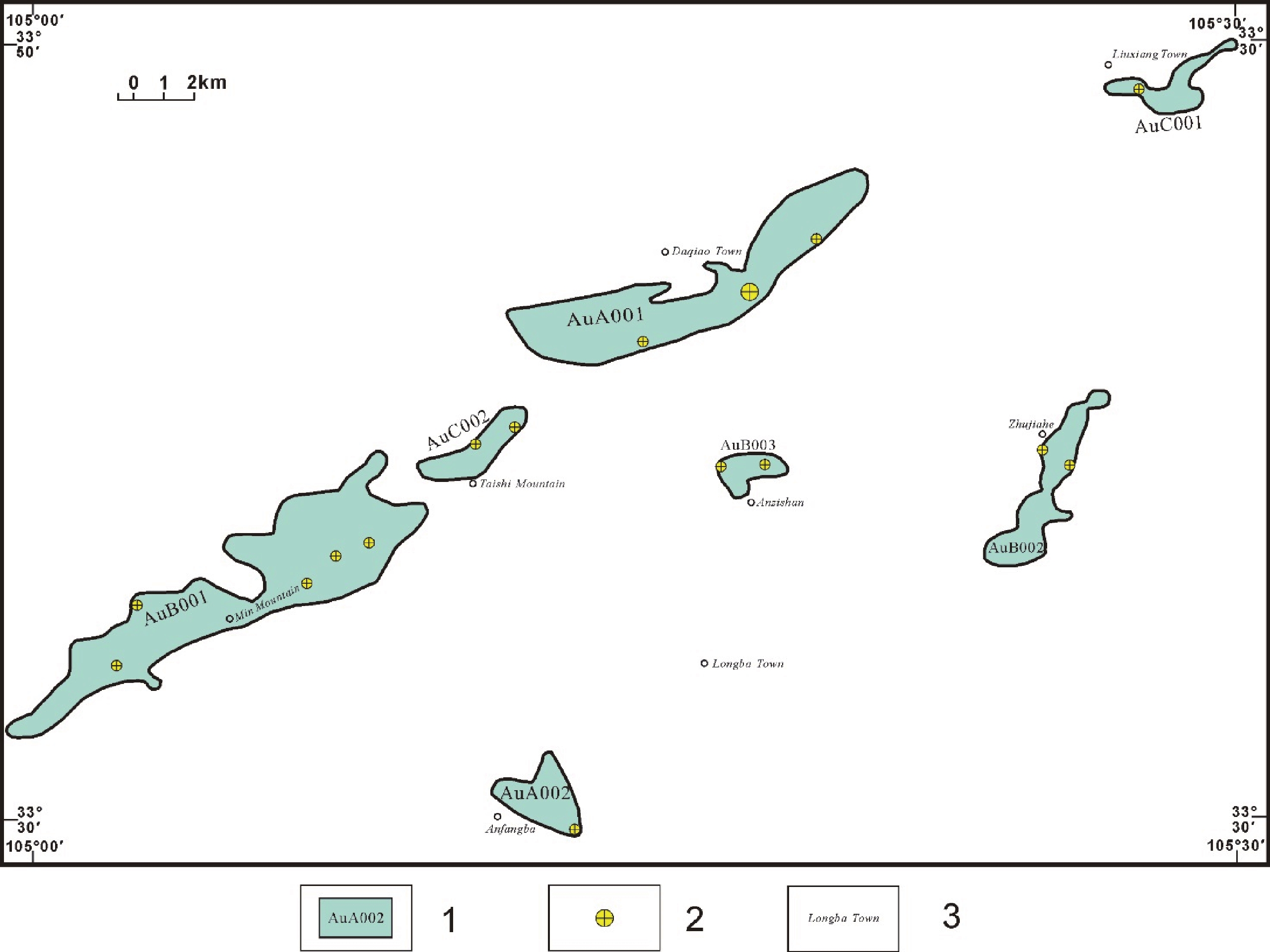
序号 靶区编号 靶区名称 靶区位置 靶区分类 1 AuA001 大桥金找矿预测靶区 大桥乡 A 2 AuA002 安房坝金找矿预测靶区 安房坝 A 3 AuB001 崖湾金找矿预测靶区 崖湾 B 4 AuB002 朱家河金找矿预测靶区 朱家河 B 5 AuB003 安子山金找矿预测靶区 安子山 B 6 AuC001 六巷金找矿预测靶区 六巷乡 C 7 AuC002 月溜坡金找矿预测靶区 太石山 C
下载: 导出CSV
Table 1. Metadata Table of Database (Dataset)
Item Description Database (dataset) name Database of 1∶50 000 Mineral Geological Map of the Shixia Map-sheet in Gansu Province Database (dataset) authors Song Xiaobing, Gansu Institute of Geological Survey
Kou Yinchuan, Gansu Institute of Geological Survey
Yan Shaobo, Gansu Institute of Geological Survey
Wang Wei, Gansu Institute of Geological SurveyData acquisition time 2018–2019 Geographical area 105°15′–105°30′E, 33°40′–33°50′N Data format *.wl, *.wt, *.wp Data size 137 MB Data service system URL http://dcc.cgs.gov.cn Fund project The geological survey project entitled Comprehensive Geological Survey and Potential Assessment Demonstration of Gold-Antimony Deposit Integrated Exploration Area in Yawan-Daqiao Area, Gansu Province (No.: 121201004000172201–66), a subproject of the project entitled Prospecting Prediction and Technological Application Demonstration of Integrated Exploration Areas initiated by the China Geological Survey Language Chinese Database (dataset) composition The Database mainly consists of a 1∶50 000 mineral geological map, metallogenic regularity maps, mineral prediction maps, and a system library Slib.
The 1∶50 000 result maps mainly include master map, corner maps, and map decorations. The master map cover sedimentary rock suites, intrusive rock suites, Quaternary, vein rocks, structures, geological boundaries, occurrence, mineral deposits (ore occurrence), alternation, geological codes, and geographic information. The corner maps mainly include the histograms of sedimentary rock suites and intrusive rock suites; maps of vein rocks, structures, and mineralized alternation and map legends; cross-sections; maps of Daqiao gold deposit, including plans of typical deposits, profiles of typical exploration lines, stereograms of typical sections, diagrams of uplifting-slipping structures in Daqiao area, and diagrams of metallogenic belts; legends of mineral types and their scale; list of mineral deposits.
The master maps of metallogenic regularity maps mainly cover ore-hosting strata, ore-bearing suites, structures, geological boundaries, occurrence, mineral deposits (ore occurrence), alternation, geological codes, and geographic, geophysical, geochemical, and remote sensing information. The corner maps of the metallogenic regularity maps consist of regional tectonic framework maps, metallogenic models of gold-antimony deposits, maps of metallogenic zone/belt location, regional metallogenic factor tables of gold and antimony, a metallogenic structure information table, and a metallogenic pedigree table.
The master maps of mineral prediction maps mainly cover ore-bearing suites, structures, geological boundaries, occurrence, deposits (ore occurrence), geological codes, geographic information, and predicted prospecting target areas. The auxiliary maps of mineral prediction maps include regional metallogenic model maps; a predictive factor table of regional low-medium temperature hydrothermal gold, antimony, and cobalt (gold) deposits; mineral deposits newly discovered and their estimated resources, and an estimated mineral reserves table.
The decorations of the result maps mainly include map titles, scale, an index map, the logo of the China Geological Survey, map frames, coordinate parameters, and signatures
下载: 导出CSV
Table 2. Attributes of occurrence in the mineral geological map of Shixia Map-sheet
No. Data item Standard code Data type Example 1 Code of occurrence feature Feature_Id string AI48E014014000000858 2 Type of occurrence feature Feature_Type string 01 3 Code of raw data Source_Id string D6008_1 4 Occurrence name Attitude_Name string Strata occurrence 5 Strike Strike int 95° 6 Dip Dip int 5° 7 Dip angle Dip_Angle int 79°
下载: 导出CSV
Table 3. Attributes of suite-tectonic map layers in the mineral geological map of Shixia Map-sheet
No. Data item Standard code Data type Example 1 Code of geological polygon entity Feature_Id string AI48E014014000000379 2 Type of geological polygon entity Feature_Type string 02 3 Name of lithostratigraphic unit Geobody_Name string The Second Member of Gansu Group 4 Stratum time Geobody_Era string N 5 Suite category Formation string Sedimentary-rock suite 6 Suite type Metallogenic string Sandy conglomerate suite 7 Lithologic association Combination string Purplish red pebbly sandstone 8 Geotectonic environment Structural_Env string Zeku foreland basin
下载: 导出CSV
Table 4. Attributes of faults in the mineral geological map of Shixia Map-sheet
No. Data item Standard code Data type Example 1 Code of fault feature Feature_Id string AI48E014014000001721 2 Type of fault feature Feature_Type string 03 3 Fault code Fault_Type string Transpressional fault 4 Fault name Fault_Name string Qingganglingshankou–Rentoushan fault 5 Fault code Fault_Code string F1-1 6 Fault characteristics Fault_Character string Thrust nappe fault 7 Motion mode of fault Fault_motion string Thrust nappe 8 Code of geologic blocks on the hanging foot wall of fault Fault_Up_Body string T2d1 9 Code of geologic blocks on the foot wall of fault Fault_Bottom_Body string D2h1 10 Fault width Fault_Wide float 100 11 Fault length Fault_Wide float 24.9 12 Fault strike Fault_Strike int 60° 13 Dip of fracture face Fault_Dip int 330° 14 Dip angle of fracture face Fault_Dip_Angle int 70° 15 Fault throw Fault_Distance float 1 16 Formation time of fault Era string Mesozoic 17 Activity stage Movement_Period string Indosinian
下载: 导出CSV
Table 5. Attributes of geological boundaries in the mineral geological map of Shixia Map-sheet
No. Data item Standard code Data type Example 1 ID of geological boundary feature Feature_Id string AI48E014014000001742 2 Type of geological boundary feature Feature_Type string 04 3 Type of geological boundary Boundary_Name string Angular unconformity 4 Code of geologic block on the left side of geological boundary Left_Boundary_Code string N1G2 5 Code of geologic block on the right side of geological boundary Right_Boundary_Code string K1j2
下载: 导出CSV
Table 6. Attributes of mineral deposit types in the mineral geological map of Shixia Map-sheet
S. No. Data item Standard code Data type Example 1 Code of mineral site feature Feature_Id string AI48E014014000000003 2 Type of mineral site feature Feature_Type string 05 3 Name of mineral deposit type Commodities_Name string Lead–zinc deposit 4 Paragenic minerals Paragenic_Ore string / 5 Associated minerals Associated_Ore string silver 6 Number of mineral deposits Ore_Sums int / 7 Ore grades Ore_Grade string Pb 0.5%, Zn 3.44% 8 Scale Deposite_Size string Medium-sized 9 Metallogenic time Metallogenetic_Epoch string Indosinian 10 Mineral deposit name Placename string Rentoushan lead–zinc deposit in Xihe County, Gansu Province 11 Genesis types Genesis_Types string Meso-epithermal lead–zinc deposit 12 Industrial type Industrial_Types string Non-ferrous lead–zinc deposit
下载: 导出CSV
Table 7. Attributes of predicted target areas in the mineral prediction map of Shixia Map-sheet
S. No. Data item Standard code Data type Example 1 Perimeter of target area Perimeter double 537.6 2 Area of target area Area double 6293.48 3 Map-sheet no. MAPCODE string I48E014014 4 Code of target area feature FEATURE_ID string A0000000000000000008 5 Type of target area feature FEATURE_Type string 06 6 Color code COLOUR string 283 7 Name of target area TARGET_NAME int Predicted target area of Daqiao gold deposit 8 No. of target area TARGET_CODE string AuA001 9 Area of target area QDTCBA float 21.14 10 Geographical location DLWZ string Daqiao Town, Xihe County, Gansu Province 11 Major mineral type KCCA string Au 12 Typical deposits DXKC string Daqiao gold deposit 13 Known deposits DXKE string Daqiao gold deposit and Yinmahe gold deposit 14 Type of target area QDTCBF string Ⅰ 15 Level of target area QDTCBT string A 16 Predicted resource PKCAAG int 160585 17 Metallogenic time KCDS string Indosinian 18 Ore-bearing strata DDDA string The first member of Triassic Huashiguan Formation 19 Geotectonic location GZAN string Lintan–Liangdang deep and large fault and Yaoshang–Shixia fault 20 Magma type YSEA string Meso-epithermal hydrothermal type 21 Geochemical characteristics QDHX string Anomalies of Ag, Au, Hg, Sb, and Sn well overlap 22 Alteration characteristics KCAGA string Silicification, pyritization, carbonatization, fluoritization
下载: 导出CSV
Table 8. List of sedimentary rock suites
Chronostratigraphic unit Lithostratigraphic unit Characteristics of suite units System Series Formation Code Suite type Thickness/ m Lithology Quaternary Holocene Qhpal 15 Alluvial-diluvial sand, sand gravel, and sandy loam Pleistocene Qpeol 5−10 Loess-like silty clay, silty soil, and pebbly sandy soil Neogene N1Ga Sandy conglomerate suite 1179 Brick-red sandy conglomerate interbedded with muddy siltstone and silty mudstone Cretaceous Jishan Formation K1j2a Sandy conglomerate suite 282 Purplish-red sandy conglomerate Triassic Middle Triassic Daheba Formation T2d1c Suite consisting of alternating layers of silty slate and sandstone 923 Grayish-brown silty slate and grayish-green sandstone T2d1b Suite consisting of calcareous slate interbedded with thin laminated limestone 500 Grayish-yellow calcareous slate interbedded with thin laminated limestone and a small amount of sandstone T2d1a Suite consisting of silty slate interbedded with sandstone 437 Gray silty slate interbedded with sandstone Huashiguan Formation T2h2a Suite consisting of calcareous slate interbedded with thin laminated limestone and sandstone 679 Gray calcareous slate interbedded with caesious thin laminated limestone, a small amount of brecciaous limestone and thin laminated sandstone T2h1d Suite consisting of calcareous slate interbedded with thin laminated limestone 500 Gray calcareous slate interbedded with caesious thin laminated limestone and a small amount of brecciaous limestone T2h1c Suite of silty slate interbedded with thin laminated limestone 400 Gray and caesious silty slate interbedded with thin laminated limestone and brecciaous limestone T2h1b Silicified sandy conglomerate suite 5−216 Polymictic breccia composed of silicified sandy conglomerate and lamellar siliceous rock T2h1a Thin laminated limestone suite 30 Caesious thin laminated limestone Carboniferous Upper Carboniferous Minhe Formation C2ma Thick laminated limestone suite 301 Hoary thick laminated limestone and marblized limestone Devonian Upper
DevonianHonglingshan Formation D3hla Suite consisting of alternating layers of thick laminated limestone and phyllitic slate 1472 Alternating layers of dark-gray thick laminated limestone and light grayish-green phyllitic slate Middle
DevonianHuangjiagou Formation D2h3a Suite consisting of phyllite interbedded with medium-thick laminated limestone 260.30 Light grayish-green phyllite interbedded with medium-thick laminated limestone D2h2b Suite consisting of thin-medium laminated limestone interbedded with silty slate 400 Gray thin-mid laminated limestone interbedded with silty slate, siliceous rock, and a small amount of sandstone D2h2a Suite consisting of slate interbedded with limestone and sandstone 589 Gray calcareous slate, silty slate, and grayish phyllitic slate interbedded with thin-medium laminated limestone, calcareous feldspar quartz sandstone, a small amount of thick laminated limestone, and bioclastic limestone D2h1a Suite consisting of silty slate interbedded with sandstone 968 Alternating layers consisting of grayish silty slate and a small amount of calcareous slate and grayish-brown calcareous lithic quartz sandstone and calcareous feldspar quartz sandstone Lower
DevonianAnjiacha Formation D1h2a Suite consisting of alternating layers of silty slate and sandstone 1040 Gray silty slate interbedded with medium-thin laminated sandstone Silurian Upper Silurian Zhuowukuo Formation S3-4zw3a Suite consisting of silty slate interbedded with thick laminated limestone and siliceous rocks 1308 Grayish-brown silty slate interbedded with gray thin laminated limestone and grayish-black siliceous rock S3-4zw2a Suite of medium-thick laminated limestone interbedded with clastic rock 973 Dark-gray medium-thick laminated limestone and calcarenite interbedded with gray siltstone, grayish-brown silty slate, and dark-gray siliceous rock
下载: 导出CSV
Table 9. List of prospecting target areas
No. Code of prospecting target areas Name of prospecting target areas Location of prospecting target areas Level of prospecting target areas 1 AuA001 Daqiao gold prospecting target areas Daqiao Town A 2 AuA002 Anfangba gold prospecting target areas Anfangba A 3 AuB001 Yawan gold prospecting target areas Yawan B 4 AuB002 Zhujiahe gold prospecting target areas Zhujiahe B 5 AuB003 Anzishan gold prospecting target areas Anzishan B 6 AuC001 Liuxiang gold prospecting target areas Liuxiang Town C 7 AuC002 Yueliupo gold prospecting target areas Tanshi Mountain C
下载: 导出CSV
-
[1] Liu Yunhua, Han Yixiao, Wei Juzhen, Teng Fei, Tian Runqing, Gao Zuoyu. 2018. Geological and geochemical characteristics and prospecting potential of the Daqiao hot spring–type gold deposit in the west Qinling Orogen[J]. Geological Journal, 53: 136−146. doi: 10.1002/gj.3077
[2] 贺根文, 于长琦, 李伟, 刘孝斌, 周兴华. 2019. 赣南于都金银多金属矿整装勘查区1∶50 000银坑幅矿产地质图数据集[J]. 中国地质, 46(S1): 66−74. doi: 10.12029/gc2019Z108
[3] 李通国, 司国强, 盖艾鸿. 2000. 西秦岭金矿类型及成矿区带划分[J]. 甘肃地质学报, 9(1): 51−58. https://www.cnki.com.cn/Article/CJFDTOTAL-GSDZ200001006.htm
[4] 李永军, 李英, 刘志武, 赵仁夫, 金治鹏, 董俊刚. 2002. 西秦岭金矿成矿系列[J]. 矿床地质, 21(S1): 156−159. https://www.cnki.com.cn/Article/CJFDTOTAL-KCDZ2002S1047.htm
[5] 刘月高, 吕新彪, 张振杰, 尤关进, 曹晓峰, 王玉奇, 刘阁. 2011. 甘肃西和县大桥金矿床的成因研究[J]. 矿床地质, 30(6): 1085−1099. doi: 10.3969/j.issn.0258-7106.2011.06.009
[6] 刘翠辉, 于长琦, 贺根文, 李伟, 刘孝斌. 2019. 赣南宁都地区1: 50 000青塘幅矿产地质图数据集[J]. 中国地质, 46(S1): 75−83. doi: 10.12029/gc2019Z109
[7] 宋小兵, 寇银川, 闫少波, 王伟. 2020. 甘肃省石峡幅 1∶50 000 矿产地质图数据库]DB/OL].地质科学数据出版系统. (2020–12 –30). DOI: 10.35080/data.C.2020.P28.
[8] 肖力, 张继武, 崔龙, 赵玉锁, 潘爱军, 邹依林, 韩先菊, 张勇. 2008. 西秦岭地区金矿控矿因素和资源潜力分析[J]. 黄金, 29(7): 17−22. https://www.cnki.com.cn/Article/CJFDTOTAL-HJZZ200807005.htm
[9] 叶天竺, 吕志成, 庞振山, 等. 2014. 勘查区找矿预测理论与方法(总论)[M]. 北京: 地质出版社.
[10] 叶天竺, 韦昌山, 王玉往, 祝新友, 庞振山, 姚书振, 秦克章, 韩润生, 叶会寿, 孙景贵, 蔡煜琦, 甄世民, 薛建玲, 范宏瑞, 倪培, 曾庆栋, 蒋少涌, 杜杨松, 李胜荣, 郝立波, 张均, 陈正乐, 耿林, 潘家永, 蔡锦辉, 黄智龙, 李厚民, 孙丰月, 陈衍景, 陈郑辉, 杜泽忠, 陶文, 肖昌浩, 张志辉, 贾儒雅, 陈辉, 姚磊. 2017. 勘查区找矿预测理论与方法(各论)[M]. 北京: 地质出版社.
[11] 张国伟, 孟庆任, 于在平, 孙勇, 周鼎武, 郭安林. 1996. 秦岭造山带的造山过程及其动力学特征[J]. 中国科学: D辑, 26(3): 193−200. https://www.cnki.com.cn/Article/CJFDTOTAL-JDXK199603000.htm
[12] 张新虎, 刘建宏, 赵彦庆. 2008. 甘肃省成矿区(带)研究[J]. 甘肃地质, 17(2): 1−8+49. https://www.cnki.com.cn/Article/CJFDTOTAL-GSDZ200802003.htm
[1] He Genwen, Yu Changqi, Li Wei, Liu Xiaobin, Zhou Xinghua. 2019. The 1∶50 000 mineral geological map dataset of the Yinkeng Map-sheet, Yudu Au-Ag multi-metal ore Integrated Area, South Jiangxi[J]. Geology in China, 46(S1): 87−99.
[2] Liu Yunhua, Han Yixiao, Wei Juzhen, Teng Fei, Tian Runqing, Gao Zuoyu. 2018. Geological and geochemical characteristics and prospecting potential of the Daqiao hot spring-type gold deposit in the west Qinling Orogen[J]. Geological Journal, 53: 136−146. doi: 10.1002/gj.3077
[3] Li Tongguo, Si Guoqiang, Gai Aihong. 2000. Gold deposit types and metallogenic belts of west Qinling area[J]. Acta Geologica Gansu, 9(1): 51−58 (in Chinese with English abstract).
[4] Li Yongjun, Li Ying, Liu Zhiwu, Zhao Renfu, Jin Zhipeng, Dong Jungang. 2002. Study on gold metallogenic series in Western Qinling[J]. Mineral Deposits, 21(S1): 156−159 (in Chinese with English abstract).
[5] Liu Cuihui, Yu Changqi, He Genwen, Li Wei, Liu Xiaobin. 2019. The 1∶50 000 mineral geological map dataset of the Qingtang Map-sheet, Ningdu, South Jiangxi[J]. Geology in China, 46(S1): 100−111.
[6] Liu Yuegao, Lu Xiaobao, Zhang Zhenjie, You Guanjin, Cao Xiaofeng, WangYuqi, Liu Ge. 2011. Genesis of Daqiao gold deposit in Xihe County, Gansu Province[J]. Mineral Deposits, 30(6): 1085−1099 (in Chinese with English abstract). http://www.researchgate.net/publication/326971906_Genesis_of_Daqiao_gold_deposit_in_Xihe_County_Gansu_Province
[7] Song Xiaobing, Kou Yinchuan, Yan Shaobo, Wang Wei. 2020. Database of 1∶50 000 Mineral Geological Map of the Shixia Map-sheet in Gansu Province[DB/OL]. Geoscientific Data & Discovery Publishing System. (2020–12–30). DOI: 10.35080/data.C.2020.P28 .
[8] Xiao Li, Zhang Jiwu, Cui Long, Zhao Yusuo, Pan Aijun, Zou Yilin, Han Xianju, Zhang Yong. 2008. Analysis on ore-controlling factors and resource potentiality in West Qinling region gold deposit[J]. Gold, 29(7): 17−22 (in Chinese with English abstract). http://www.zhangqiaokeyan.com/academic-journal-cn_gold_thesis/0201219949205.html
[9] Ye Tianzhu, Lyu Zhicheng, Pang Zhenshan, Zhang Dehui, Liu Shiyi, Wang Quanming, Liu Jiajun, Cheng Zhizhong, Li Chaoling, Xiao Keyan, Zhen Shimin, Du Zezhong, Chen Zhengle. 2014. Theories and methods of prospecting prediction in prospecting areas (general)[M]. Beijing: Geological Publishing House (in Chinese).
[10] Ye Tianzhu, Wei Changshan, Wang Yuwang, Zhu Xinyou, Pang Zhenshan, Yao Shuzhen, Qin Kezhang, Han Runsheng, Ye Huishou, Sun Jinggui, Cai Yuqi, Zhen Shimin, Xue Jianling, Fan Hongrui, Ni Pei, Zeng Qingdong, Jiang Shaoyong, Du Yangsong, Li Shengrong, Hao Libo, Zhang Jun, Chen Zhengle, Geng Lin, Pan Jiayong, Cai Jinhui, Huang Zhilong, Li Houmin, Sun Fengyue, Chen Yanjing, Chen Zhenghui, Du Zezhong, Tao Wen, Xiao Changhao, Zhang Zhihui, Jia Ruya, Chen Hui, Yao Lei.2017. Theories and methods of prospecting prediction in prospecting areas (monographs)[M]. Beijing: Geological Publishing House (in Chinese).
[11] Zhang Guowei, Meng Qingren, Yu Zaiping, Sun Yong, Zhou Dingwu, Guo Anlin. 1996. The orogenic process and dynamic characteristics of the Qinling orogenic belt[J]. Science in China (Series D), 26(3): 193−200 (in Chinese).
[12] Zhang Xinhu, Liu Jianhong, Zhao Yanqing. 2008. Study on metallogenic provinces(zones) in Gansu Province[J]. Gansu Geology, 17(2): 1−8, 49 (in Chinese with English abstract).
-


图(8)
表(18)
计量
- 文章访问数: 1848
- PDF下载数: 97
- 施引文献: 0