

-
摘要:
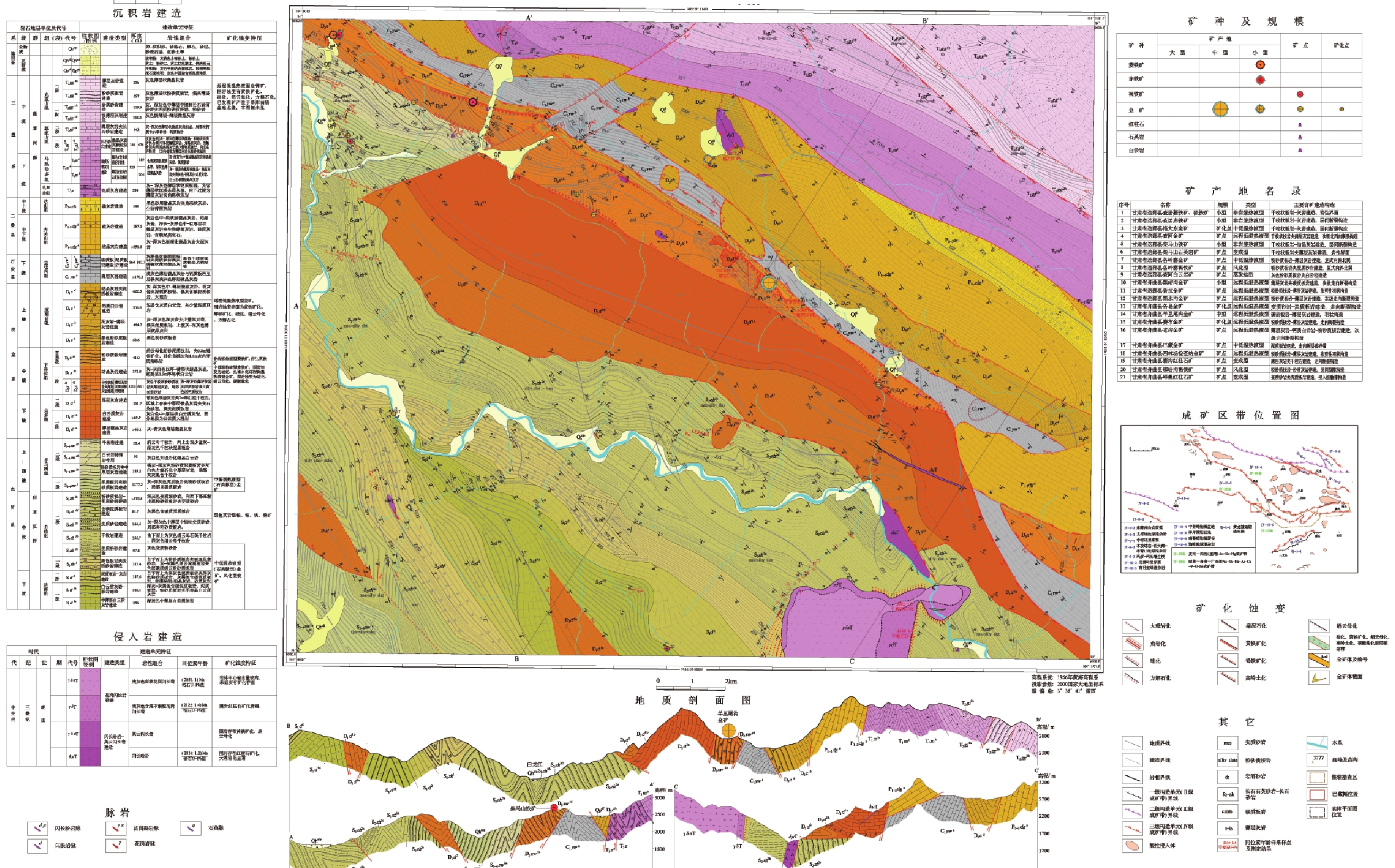
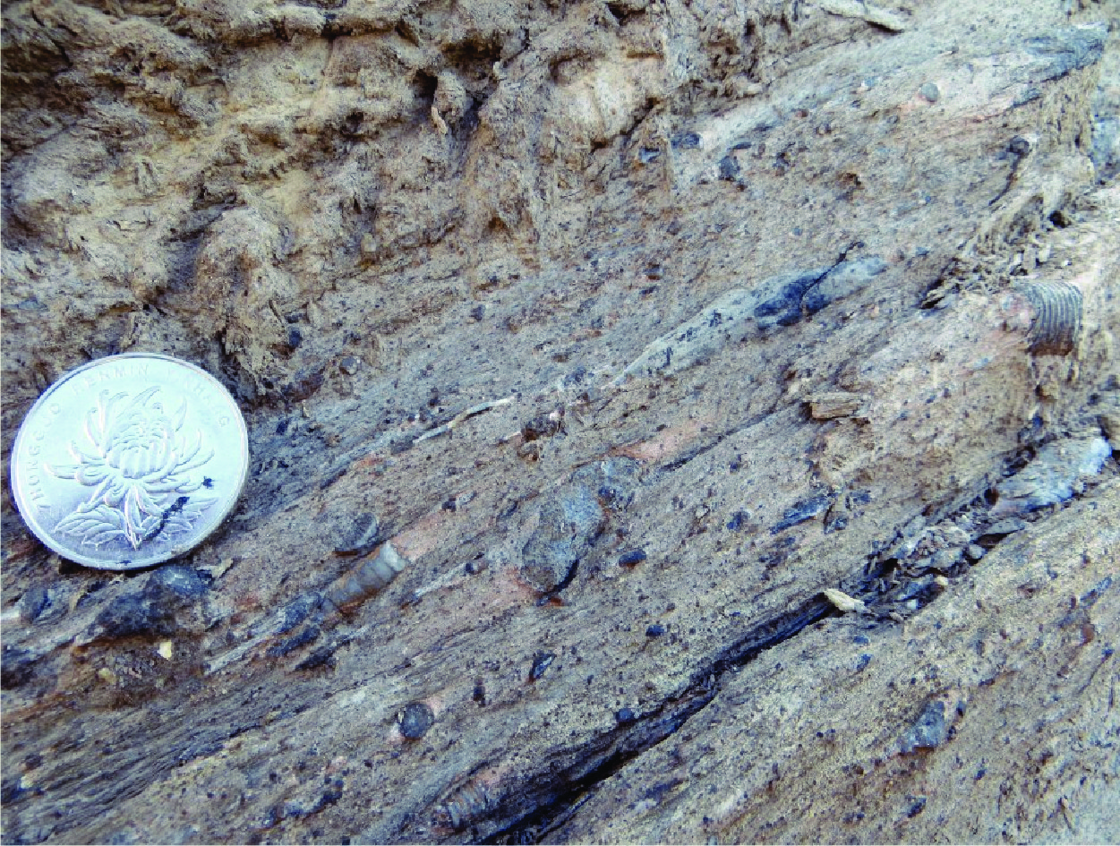
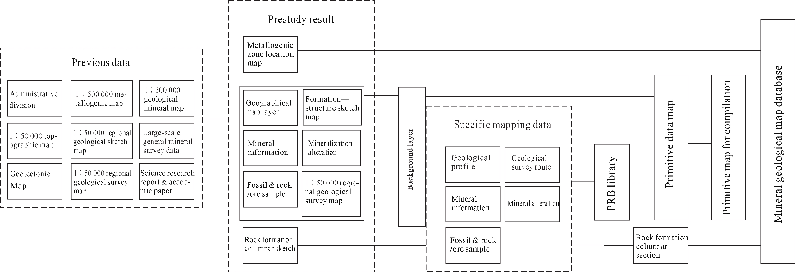
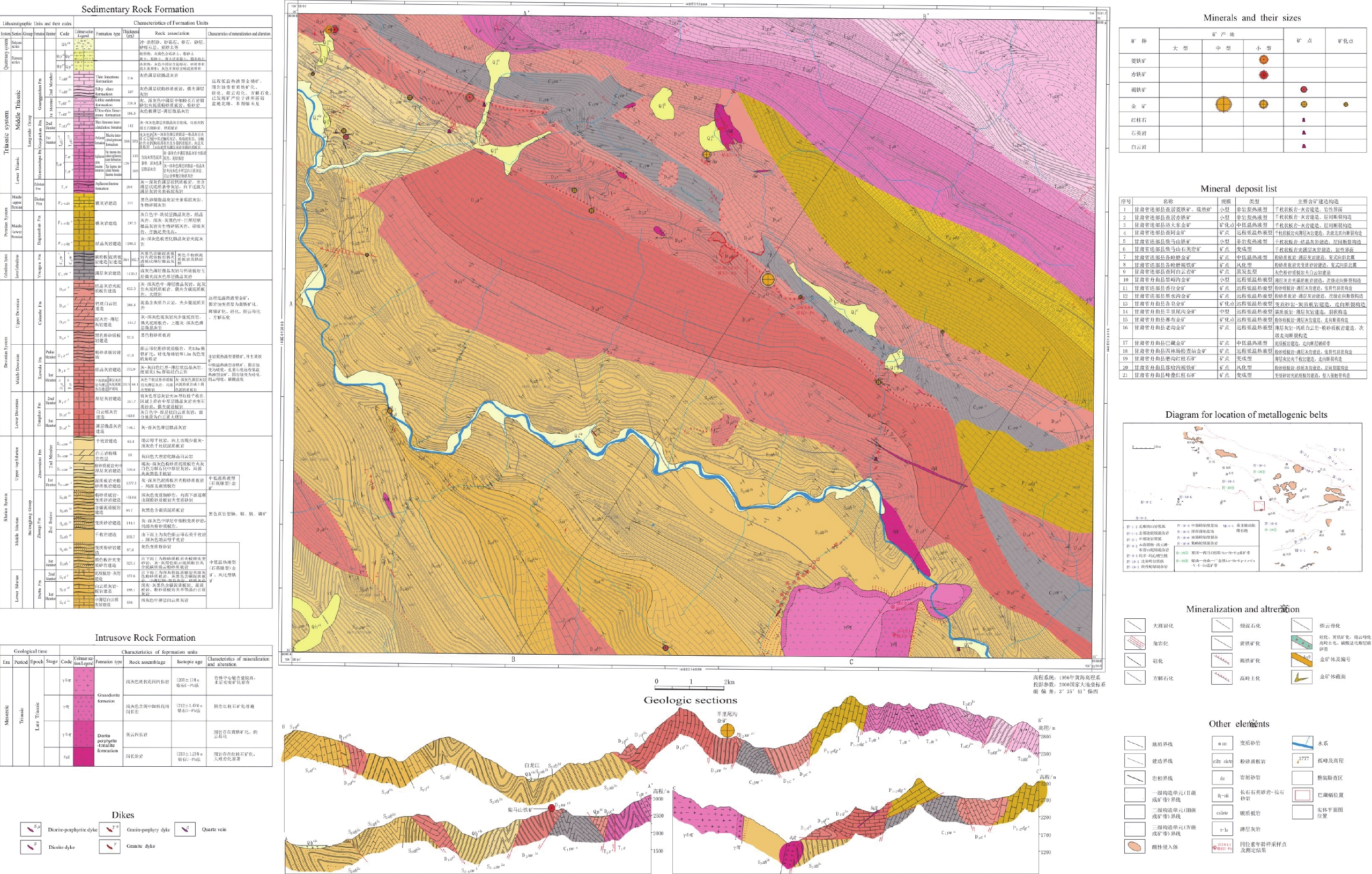
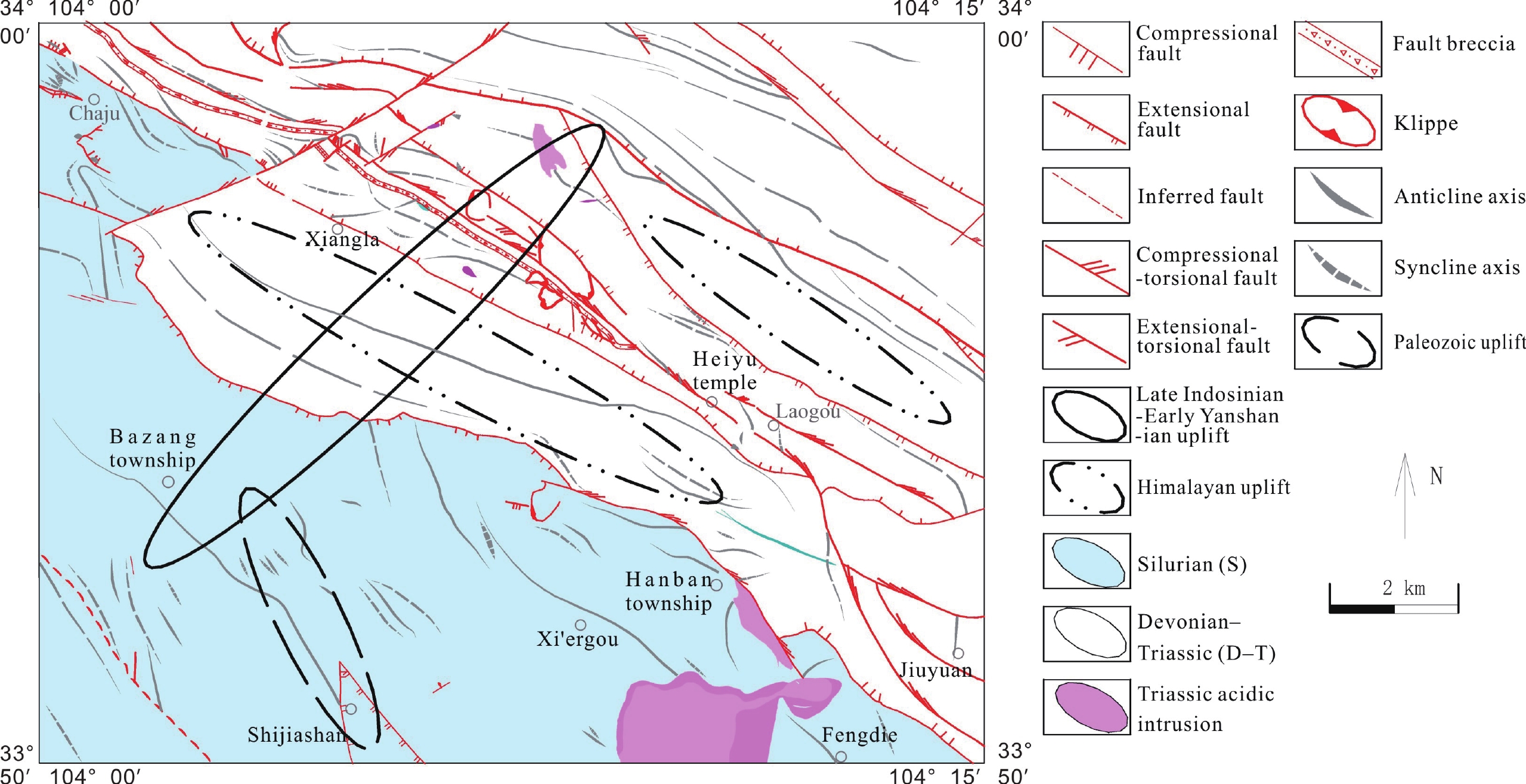
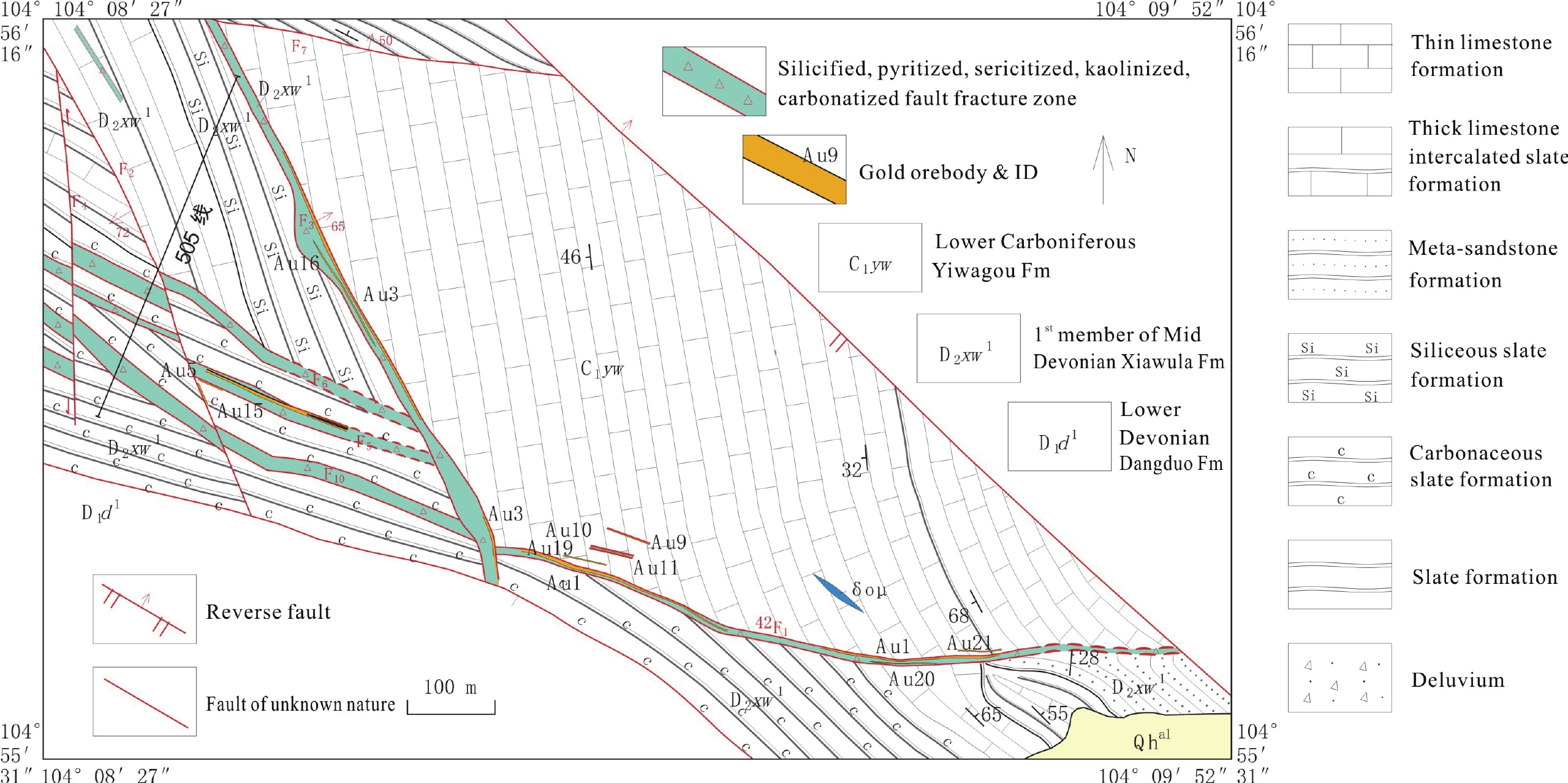
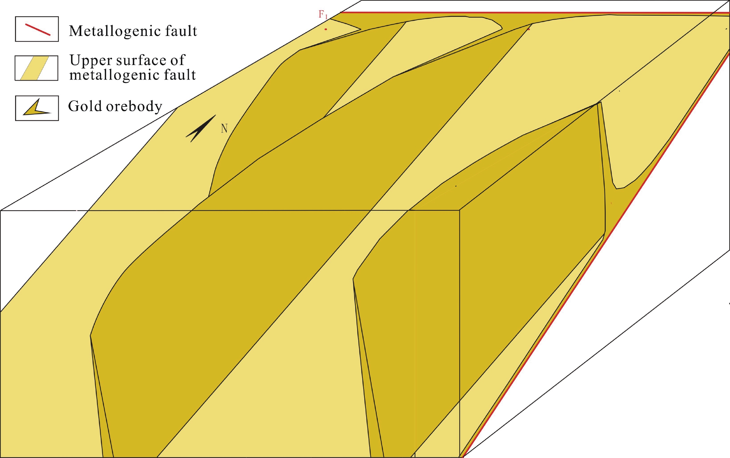
甘肃省巴藏幅(I48E013009)1∶50 000 矿产地质图数据库在《矿产地质调查成果图件编制指南(1∶50 000)》(讨论稿)和三位一体找矿预测地质模型的指导下编制完成。采用数据为既往1∶50 000区域地质调查实际材料图、矿产勘查报告、科学研究报告、论文和1∶50 000专项填图采集的数据,共形成数据记录:产状811条、地质界线102条、同位素年龄5条、化石2条、矿产信息21条、矿化蚀变带22条、断层86条、褶皱111条、建造65条。图面以主图和角图相结合地方式全面客观地表达了区域地质界线、岩石建造、年代、断层、褶皱轴迹、节理、劈理、皱纹线理、窗棂构造、断层面擦痕、矿化蚀变、矿产信息及典型矿床的成矿地质特征,其中包括加里东期风暴沉积和褶皱变形、早石炭世铁质结核及一系列新发现和新认识。在“建造构造”图层的属性中强调了含矿建造、矿化蚀变;在“断层”图层及“褶皱”构造图层的属性中强调了成矿构造。该数据库为区域成矿规律及工程地质、环境地质等领域的调查研究提供了基础资料,可供使用者根据需求进行检索。本文提交的巴藏幅MapGIS空间数据库数据量约为90.2 MB,Access数据库2.51 MB。
Abstract:The 1∶50 000 mineral geological map database of the Bazang Map-sheet (I48E013009), Gansu was compiled under the guidance of the Guide for Compiling Maps of Mineral Geological Survey Results (draft for discussion) and the three-in-one ore prospecting prediction geological model. The collected data include the previous 1∶50 000 regional geological survey primitive data maps, mineral investigation reports, scientific research reports, academic papers, and gathered data in the 1∶50 000 specific mapping. Data records include 811 entries on attitude, 102 on geological boundary, 5 on isotopic age, 2 on fossil, 21 on mineral information, 22 on mineralization alteration, 86 on fault, 111 on fold, and 65 on formation. The map face is a combination of the master map and corner maps to give a full, objective presentation of the regional geological boundaries, rock formations, eras, faults, fold axial traces, joints, cleavages, wrinkle lineations, mullion structures, fault plane striations, mineralization alterations, mineral information, and the metallogenic geology of typical deposits, covering the Caledonian storm deposits and fold deformations, Early Carboniferous ferruginous nodules, and a series of new discoveries and new understandings. In the attributes of the “formation-structure” layer, ore-bearing formations and mineralization alterations are emphasized. In the “fault” layer and “fold” structure layer, ore-forming structures are emphasized. The database provides basic data for the investigation and research of regional metallogenesis as well as engineering geology and environmental geology, and can be retrieved by users whenever so needed. The data volume of the Bazang Map-sheet is approximately 90.2 MB for the MapGIS spatial database and 2.51 MB for the Access database.
-

-
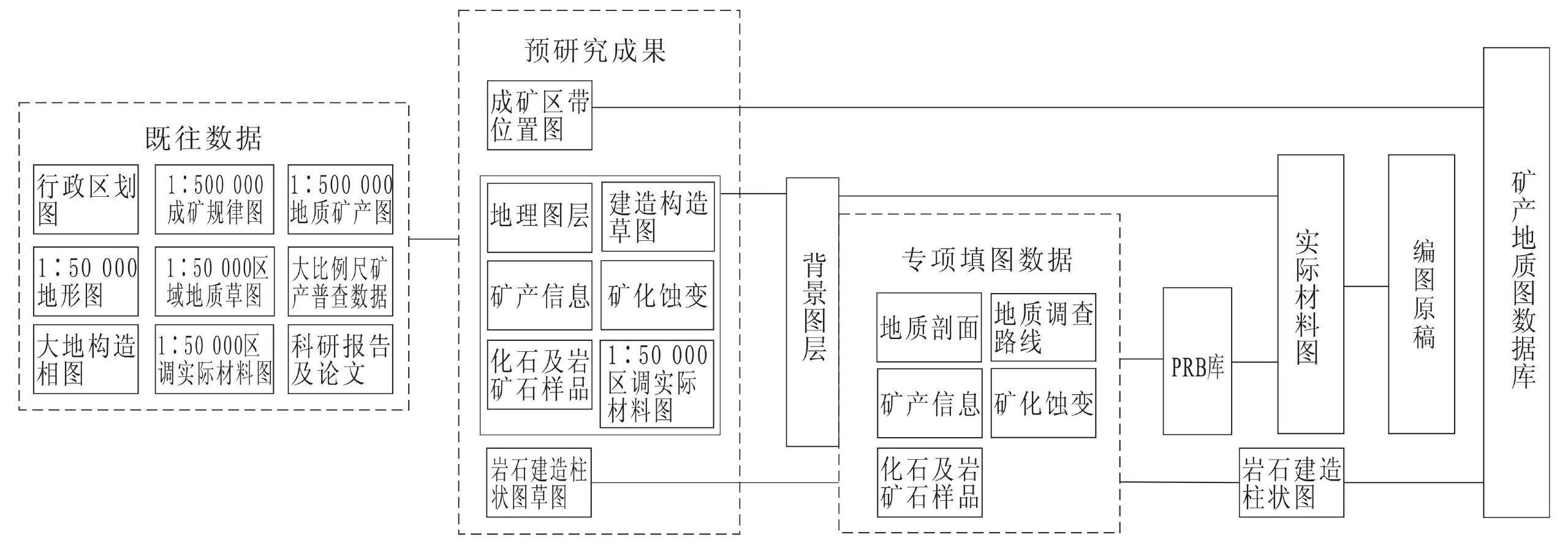
表 1 数据库(集)元数据简介
条目 描述 数据库(集)名称 甘肃省巴藏幅1∶50 000矿产地质图数据库 数据库(集)作者 何进忠,甘肃省地质调查院,野外数据采集、入库,数据质量检查
吕传元,甘肃地矿局第三地质矿产勘查院,野外数据采集
曹海龙,甘肃省地质调查院,野外数据采集及部分路线整理
张祥年,甘肃省地质调查院,野外数据采集
武 凌,甘肃省地矿局第二地质矿产勘查院,图形数据采集
牛鹏飞,甘肃省地质调查院,数据质量检查数据时间范围信息 2016年6月—2019年3月 地理区域 104°~104°15′ E;33°50′~34° N 数据格式 MapGIS 6.7(*.WT,*.WL,*.WP) 数据量 90.2 MB 数据服务系统网址 http://dcc.cgs.gov.cn 基金项目 中国地质调查局地质调查项目“甘肃崖湾−大桥地区金锑矿整装勘查区(巴藏幅)矿产调查与找矿预测” (121201004000150017–35) 语种 中文 数据集组成 基本要素类包括地质(界)线、河、水库岸线、脉岩(点)、矿产地(点)、产状、样品、同位素采样点、化石;综合要素类包括标准图框(内图框)、岩石建造花纹、图切剖面;独立要素类包括责任表、接图表、图例、综合柱状图、图切剖面、典型矿床角图、其他辅助角图(构造纲要图和成矿区带位置图);对象类包括断层、褶皱、建造构造(面)、矿化蚀变、图幅基本信息  下载: 导出CSV
表 2 成果图件数据库提交目录
一级目录 二级目录 三级目录 文件名称 说明 I48E013009
成果数据库I48E013009
矿产地质图MAP -Geopolygon.WP
-Geoline
……用于输出的全要素图形数据、工程文件以及图整饰文件。左下角原点,底边水平 MAPGIS高斯(北京、西安、2000) -Geopolygon.WP
-Geoline
……按规范命名的具有投影参数的所有要素类文件 METADATA矿产地质图.XML 元数据文件 MDB BASE-FCLS.MDB
DSGMAP.MDB
SYNTH-FCLS.MDB要素类、对象类数据表 README LEGEND 图式图例说明及系统库增加的内容说明 ADD-LAYER 增加的图层说明 质量检查表 自检、互检、抽检记录
下载: 导出CSV
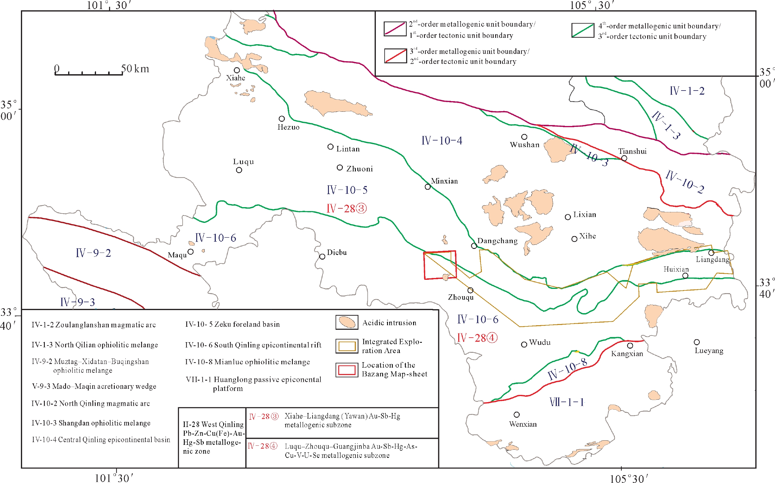
表 3 甘肃巴藏幅矿产地质图图层结构
图层类别 图层名称 地理图层 图框(.WT、.WL、.WP)、主要行政境界(.WL)、主要居民点(.WT)、主要面状水系(.WP)、主要线状水系(.WL)、主要地理标注(.WT) 建造构造图层 建造构造(.WP)、地质(界)线(.WL)、构造变形带(.WP)、褶皱(.WL)、断层(.WL)、产状要素(.WT)、重要钻孔(.WT)、化石样点(.WT)、同位素年龄(.WT) 矿产地图层 矿产地(.WT) 整饰图层图内部分 地质注记(.WT)、建造花纹(线)、指引线(.WL)、断层倾向倾角及断层性质(.WT)、产状倾角(.WT)、同位素注记(.WT)、图切剖面(.WT、.WL)、方里网(.WT、.WL) 整饰图层图外部分 接图表(.WL)、图例(.WT、.WL、.WP)、建造柱状图(.WT、.WL、.WP)、图切剖面(.WT、.WL、.WP)、典型矿区图件(.WT、.WL、.WP)、责任表(.WT、.WL)、图外其他整饰(.WT、.WL) 增设图层 矿化蚀变(DZKHSB.WT、DZKHSB.WL)、建造界线 (DZJZJX.WL)、居民地(DLJJBZ2K.WT)、地名(DLDMBZ.WT)、高程点(DLGCDBZ.WT)、主要居民地(DLJMDBZ.WT)和井泉(DLJQBZ.WT); 图名(MAP_NAME.WT)
下载: 导出CSV
Table 1. Metadata Table of Database (Dataset)
Items Description Database (dataset) name 1∶50 000 Mineral Geological Map Database of the Bazang Map-sheet (I48E013009), Gansu Database (dataset) authors He Jinzhong, Gansu Institute of Geological Survey, field data acquisition and entry, data quality check
Lyu Chuanyuan, The Third Geological Mineral Exploration Institute of Gansu Provincial Geology and Mineral Bureau, field data acquisition
Cao Hailong, Gansu Institute of Geological Survey, field data acquisition & reorganization of some of the routes
Zhang Xiangnian, Gansu Institute of Geological Survey, field data acquisition
Wu Ling, The Second Geological Mineral Exploration Institute of Gansu Provincial Geology and Mineral Bureau, graphic data acquisition
Niu Pengfei, Gansu Institute of Geological Survey, data quality checkData acquisition time Jun 2016–Mar 2019 Geographical area 104°–104°15′ E; 33°50′–34° N Data format MapGIS 6.7(*.WT, *.WL, *.WP) Data size 90.2 MB Data service system URL http://dcc.cgs.gov.cn Fund project China Geological Survey Project Mineral Survey and Prospecting Prediction of the Integrated Exploration Area of Gold Antimony Deposits in Yawan–Daqiao, Gansu (No.: 121201004000150017–35) Language Chinese Database (dataset) composition Basic feature classes include geological (boundary) lines, rivers/reservior shorelines, dykes (spots), mineral deposits (ore occurrences), attitudes, samples, isotopic sampling points, and fossils. Comprehensive feature classes include standard map frames (internal map frames), rock formation patterns, and transverse cutting profiles. Independent feature classes include duty tables, index maps, legends, integrated columnar sections, transverse cutting profiles, typical deposit corner maps, and other auxiliary maps (tectonic outline maps and metallogenic zone location maps). Object classes include faults, folds, formations and structure (planes), mineralization alterations, and basic information of the Map-sheet
下载: 导出CSV
Table 2. Directory for submission of the result map database
L1 Directory L2 Directory L3 Directory File Name Description I48E013009 Result database I48E013009 Mineral geological map MAP -Geopolygon.WP
-Geoline
……Used for total-feature graphic data, engineering files & map finishing files outputted. Origin at bottom left corner, bottom level MAPGISGauss (Beijing, Xi’an, 2000) -Geopolygon.WP
-Geoline
……All feature class files named per standard and with projection parameters METADATA of the mineral geological map.XML Metadata file MDB BASE-FCLS.MDB
DSGMAP.MDB
SYNTH-FCLS.MDBFeature class, object class access files README LEGEND Annotations of scheme & legend and added contents in SLIB ADD-LAYER Annotations of added layers Quality check sheet Record of self-check, mutual check, spot check
下载: 导出CSV
Table 3. Layer structure of the Mineral Geological Map of the Bazang Map-sheet, Gansu
Layer Type Layer Name Geographic layer Frame (.WT,.WL,.WP), main administrative boundary (.WL), main settlement (.WT), main areal drainage system (.WP), main linear drainage system (.WL), main geologic annotation (.WT) Formation–structure layer Formation and structure (.WP), geological (boundary) line (.WL), tectonic deformation zone (.WP), fold (.WL), fault (.WL), attitude feature (.WT), important drillhole (.WT), fossil sampling point (.WT), isotopic age (.WT) Mineral deposit layer Mineral deposit (.WT) Finishing layer: internal part Geological annotation (.WT), formation pattern (line), leader line (.WL), fault dip direction, dip angle & fault nature (.WT), attitude dip angle (.WT), isotope annotation (.WT), transverse cutting profile (.WT,.WL), square grid (.WT,.WL) Finishing layer: external part Index map (.WL), legend (.WT,.WL,.WP), formation columnar section (.WT,.WL,.WP), transverse cutting profile (.WT,.WL,.WP), typical mineral area map (.WT,.WL,.WP), duty table (.WT,.WL), other external decoration (.WT,.WL) Additional layer Mineralization alteration (DZKHSB.WT, DZKHSB.WL), formation boundary (DZJZJX.WL), settlement (DLJJBZ2K.WT), place name (DLDMBZ.WT), elevation point (DLGCDBZ.WT), main settlement (DLJMDBZ.WT) and well spring (DLJQBZ.WT); map name (MAP_NAME.WT)
下载: 导出CSV
-
[1] Hu R Z, Su W C, Bi X W. 2002. Geology and geochemistry of Carlin–type gold deposits in China[J]. Mineralium Deposita, 37: 378−392. doi: 10.1007/s00126-001-0242-7
[2] Zhang F X, Zhang J. 2003. Geological–Geochemical characteristics of Carlin– and Carlin–like–type gold deposits in south Qinling mountains[J]. Chinese journal of geochemistry, 22(1): 11−22. doi: 10.1007/BF02831541
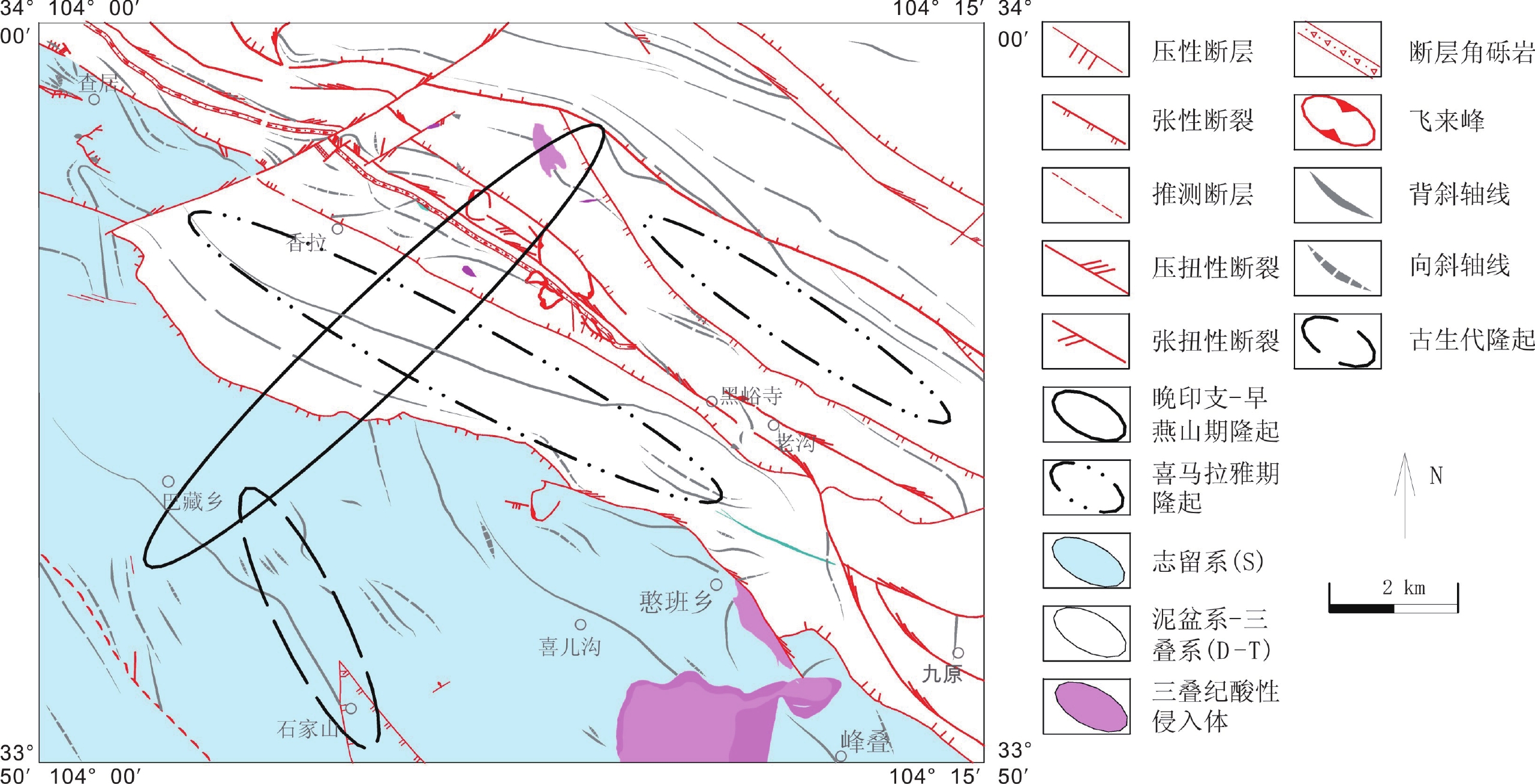
[3] 白志强, 刘树根, 宋金民, 彭瀚霖, 林彤, 柳存喜. 2015. 米仓山南缘中志留统罗惹坪组风暴岩沉积特征及其意义[J]. 中国地质, 33(2): 226−231. https://www.cnki.com.cn/Article/CJFDTOTAL-CJXB201502002.htm
[4] 曹宣铎, 张瑞林, 张汉文. 1990. 秦巴地区泥盆纪地层及重要含矿层位形成环境的研究[J]. 中国地质科学院西安地质矿产研究所所刊, 27: 1−127. https://www.cnki.com.cn/Article/CJFDTOTAL-XBFK199001000.htm
[5] 杜远生, 殷鸿福, 王治平. 1997. 秦岭造山带晚加里东–早海西期的盆地格局与构造演化[J]. 地球科学, 22(4): 401−405. https://www.cnki.com.cn/Article/CJFDTOTAL-DQKX704.015.htm
[6] 冯永忠, 李亚东. 2005. 韧脆性复成断裂构造对白龙江地区金矿成矿的控制规律及成矿预测[J]. 甘肃地质学报, 14(1): 42−47. https://www.cnki.com.cn/Article/CJFDTOTAL-GSDZ200501008.htm
[7] 甘肃省地质矿产局. 1997. 甘肃岩石地层[M]; 武汉: 中国地质大学出版社. 1–290.
[8] 甘肃省地质矿产局区调队. 1986. 西秦岭南坡的志留系[J]. 甘肃地质, 5: 33−63. https://www.cnki.com.cn/Article/CJFDTOTAL-GSDZ198600001.htm
[9] 何进忠, 吕传元, 曹海龙, 张祥年, 武凌, 牛鹏飞. 2020. 甘肃省巴藏幅1∶50 000矿产地质图数据库[DB/OL]. 地质科学数据出版系统. (2020-12-30). DOI: 10.35080/data.C.2020.P29.
[10] 何高文, 孙晓明, 杨胜雄, 朱克超, 宋成兵. 2011. 太平洋多金属结核和富钴结壳稀土元素地球化学对比及其地质意义[J]. 中国地质, 38(2): 462−472. doi: 10.3969/j.issn.1000-3657.2011.02.020
[11] 刘明强. 2012. 甘肃西秦岭舟曲憨班花岗岩体的单颗粒锆石U–Pb年龄及地质意义[J]. 地质科学, 47(3): 899−907. doi: 10.3969/j.issn.0563-5020.2012.03.023
[12] 李亚东. 1994. 白龙江地区逆冲推覆构造及其与金矿的关系[J]. 贵金属地质, 3(4): 262−269. https://www.cnki.com.cn/Article/CJFDTOTAL-GJSD404.002.htm
[13] 李鸿睿, 胡积球, 马涛. 2011. 甘肃迭部县尖尼—桑坝一带金地球化学特征及找矿意义[J]. 甘肃地质, 20(1): 24−27. https://www.cnki.com.cn/Article/CJFDTOTAL-GSDZ201101005.htm
[14] 李通国. 2001. 九源一坪定金矿床地球化学特征及异常模式研究[J]. 西北地质, 17(1): 24−31. https://www.cnki.com.cn/Article/CJFDTOTAL-XBDI601.004.htm
[15] 李通国, 谢建强. 1998. 白龙江中上游地区金矿控矿因素及成矿模式探讨[J]. 甘肃地质学报, 7(1): 63−72. https://www.cnki.com.cn/Article/CJFDTOTAL-GSDZ801.003.htm
[16] 李超岭. 2011. 数字地质调查系统操作指南(中)[M]. 北京: 地质出版社, 3–450.
[17] 彭东, 林丽, 王全伟, 阚泽忠, 付小方, 彭波. 2011. 甘孜–理塘结合带锰结核的发现及其地质意义[J]. 中国地质, 38(2): 442−450. doi: 10.3969/j.issn.1000-3657.2011.02.018
[18] 田莉莉, 张建辉, 陈国忠, 赵向农. 2003. 甘肃省迭部刀扎—舟曲憨班一带金矿找矿新认识[J]. 甘肃地质学报, 12(2): 73−79. https://www.cnki.com.cn/Article/CJFDTOTAL-GSDZ200302014.htm
[19] 谭光裕. 1992. 坪定砷金矿床地质特征及成矿机制探讨[J]. 甘肃地质学报, 1(1): 48−56. https://www.cnki.com.cn/Article/CJFDTOTAL-GSDZ199201005.htm
[20] 田景春, 张翔, 林小兵, 孟万斌, 王峰. 2014. 事件沉积学[M]. 北京: 地质出版社. 68–72.
[21] 王根宝, 冯华, 焦建宏. 1998. 论南秦岭加里东运动[J]. 陕西地质, 16(1): 3−5. https://www.cnki.com.cn/Article/CJFDTOTAL-SXDY199801001.htm
[22] 王东华, 陈耀宇, 雷祥军, 柳生祥, 赵向农, 邓喜涛, 李学册. 2015. 舟曲羊里尾沟金矿地质矿化特征及找矿标志[J]. 甘肃地质, 24(4): 28−36. https://www.cnki.com.cn/Article/CJFDTOTAL-GSDZ201504005.htm
[23] 王东华, 杨华奎, 李学册. 2014. 甘肃省舟曲县羊里尾沟金矿地质特征及找矿前景分析[J]. 甘肃科技, 30(16): 26−30. doi: 10.3969/j.issn.1000-0952.2014.16.011
[24] 于淼, 邓希光, 姚会强, 刘永刚. 2018. 世界海底多金属结核调查与研究进展[J]. 中国地质, 45(1): 49−58. https://www.cnki.com.cn/Article/CJFDTOTAL-DIZI201801004.htm
[25] 叶天竺, 吕志成, 庞振山, 张德会, 刘士毅, 王全明, 刘家军, 程志中, 李超岭, 肖克炎, 甄世民, 杜泽忠, 陈正乐. 2014. 勘查区找矿预测理论与方法[M]. 北京: 地质出版社. 1–565.
[26] 叶连俊, 关士聪. 1945. 甘肃中南部地质志[M]; 重庆: 重庆北碚本所印行. 1–565.
[27] 张复新, 于岚. 2002. 秦岭造山带斜向俯冲–碰撞与南秦岭金–铅锌矿床成矿作用的响应[J]. 矿床地质, 21(suppl.): 297−300. https://www.cnki.com.cn/Article/CJFDTOTAL-KCDZ2002S1084.htm
[28] 翟裕生, 彭润民, 邓军, 王建平. 2001. 区域成矿学与找矿新思路[J]. 现代地质, 15(2): 101−106. https://www.cnki.com.cn/Article/CJFDTOTAL-XDDZ200102006.htm
[29] 张国伟, 孟庆任, 赖绍聪. 1995. 秦岭造山带的结构构造[J]. 中国科学(B辑), 25(9): 994−1003. https://www.cnki.com.cn/Article/CJFDTOTAL-JBXK199509014.htm
[30] 张翔, 石连成, 程莎莎, 段晨宇, 魏永强, 邓德伟, 卢亚运. 2019. 西秦岭造山带东段航磁特征及断裂构造格架[J]. 中国地质, 46(3): 587−600. doi: 10.12029/gc20190310
[31] 郑宁, 姜在兴, 李廷栋, 耿树方, 游国庆, 何幼斌. 2010. 渤海湾盆地孤南洼陷沙三中亚段风暴沉积基本特征及其地质意义[J]. 中国地质, 37(44): 1191−1198. https://www.cnki.com.cn/Article/CJFDTOTAL-DIZI201004035.htm
[1] Bai Zhiqiang, Liu Shugen, Song Jinmin, Peng Hanlin, Lin Tong, Liu Cunxi. 2015. Sedimentary characteristics and geological implications of tempesite,Luoreping Formation,Middle Silurian in southern Micangshan[J]. Geology in China, 33(2): 226−231 (in Chinese with English abstract). http://en.cnki.com.cn/Article_en/CJFDTOTAL-CJXB201502002.htm
[2] Cao Xuanduo, Zhang Ruilin, Zhang Hanwen. 1990. On stratigraphy and sedimentary environment of important ore-bearing horizon in devonian period Qinling-Dabashan area[J]. Journal of Xi’an Institute of Geology and Mineral Resources, Chinese Academy of Geological Sciences, 27: 1−127 (in Chinese with English abstract). http://en.cnki.com.cn/Article_en/CJFDTOTAL-XBFK199001000.htm
[3] Du Yuansheng, Yin Hongfu, Wang Zhiping. 1997. The late Caledonia-early Hycynian basin’s framework and tectonic revolution of Qinling orogenic belt[J]. Earth Science——Journal of China University of Geosciences, 22(4): 401−405 (in Chinese with English abstract). http://www.researchgate.net/publication/285796403_The_late_Caledonian-early_Earynian_basin's_framework_and_tectonic_evolution_of_Qinling_orogenic_belt
[4] Feng Yongzhong, Li Yadong. 2005. The ore-controll rules and prognosis for gold metallogenesis of ductile complex fautled structure in Diebu, Gansu province[J]. Acta Geologica Gansu, 14(1): 42−47 (in Chinese with English abstract).
[5] Gansu Bureau of Geology and Mineral Resources. 1997. Stratigraphy (Lithostratic) of Gansu province[M]. Wuhan: China University of Geosciences Press, 1–290 (in Chinese).
[6] He Jinzhong, Lyu Chuanyuan, Cao Hailong, Zhang Xiangnian, Wu Ling, Niu Pengfei. 2020. 1∶50 000 Mineral Geological Map Database of the Bazang Map-sheet, Gansu[DB/OL]. Geoscientific Data & Discovery Publishing System. (2020-12-30). DOI: 10.35080/data.C.2020.P29.
[7] He Gaowen, Sun Xiaoming, Yang Shengxiong, Zhu Kechao, Song Chengbing. 2011. A Comparison of REE geochemistry between polymetallic nodules and cobalt-rich crusts in the Pacific ocean[J]. Geology in China, 38(2): 462−472 (in Chinese with English abstract).
[8] Hu RZ, Su WC, Bi XW. 2002. Geology and geochemistry of Carlin-type gold deposits in China[J]. Mineralium Deposita, 37: 378−392. doi: 10.1007/s00126-001-0242-7
[9] Li Chaoling. 2011. Operation Guide of Digital Geological Survey System (middle)[M]. Beijing: Geological Publishing House, 3–450 (in Chinese).
[10] Li HongRui, Hu Jiqiu, Ma Tao. 2011. Geochemical features of gold in Jianni-Sangba area of Diebu county, Gansu province[J]. Gansu Geology, 20(1): 24−27 (in Chinese with English abstract). http://en.cnki.com.cn/Article_en/CJFDTOTAL-GSDZ201101005.htm
[11] Li Tongguo. 2001. Geochemical characteristics and geochemical anomaly pattern of gold in the Jiuyuan-Pingding district[J]. Northwestern Geology, 17(1): 24−31 (in Chinese).
[12] Li Tongguo, Xie Jianqiang. 1998. An approach to metallotect and metallogenetic patterns of gold deposits along the middle upper reaches of Bailongjiang river area[J]. Acta Geologica Gansu, 7(1): 63−72 (in Chinese with English abstract). http://en.cnki.com.cn/Article_en/CJFDTOTAL-GSDZ801.003.htm
[13] Li Yadong. 1994. Thrust nappe structure and gold mineralization in Bailongjiang area[J]. Journal of Precious Metallic Geology, 3(4): 262−269 (in Chinese with English abstract).
[14] Liu Mingqiang. 2012. Single-grain zircon U-Pb ages and geological significance of the Hanban granite from Zhouqu(Gansu) in the west Qinling orogenic belt[J]. Chinese Journal of Geology, 47(3): 899−907 (in Chinese with English abstract).
[15] Peng Dong, Lin Li, Wang Quanwei, Kan Zezhong, Fu Xiaofang, Peng Bo. 2011. The discovery of manganese nodules in Ganzi-Litang suture zone[J]. Geology in China, 38(2): 442−450 (in Chinese with English abstract). http://www.researchgate.net/publication/287680680_The_discovery_of_manganese_nodules_in_Garze-Litang_suture_zone
[16] Regional Geological Suvreying Team of Gansu Province. 1986. The Silyrian system in southern slope of the west Qinling mountain[J]. Gansu Geology, 5: 33−63 (in Chinese with English abstract). http://en.cnki.com.cn/Article_en/CJFDTOTAL-GSDZ198600002.htm
[17] Tan Guangyu. 1992. Geological character of Pingding As-Au deposit and its metallogenic mechanism[J]. Acta Geologica Gansu, 1(1): 48−56 (in Chinese with English abstract). http://en.cnki.com.cn/Article_en/CJFDTOTAL-GSDZ199201005.htm
[18] Tian Jingchun, Zhang Xiang, Lin Xiaobing, Meng Wanbin, Wang Feng. 2014. Event sedimentology[M]. Beijing: Geological Publishing House, 68–72 (in Chinese).
[19] Tian Lili, Zhang Jianhui, Chen Guozhong, Zhao Xiangnong. 2003. New ideas for gold prospecting in the area from Daozha of Diebu County to Hanban of Zhouqu County in Gansu Province[J]. Acta Geologica Gansu, 12(2): 73−79 (in Chinese with English abstract). http://en.cnki.com.cn/Article_en/CJFDTOTAL-GSDZ200302014.htm
[20] Wang Donghua, Chen Yaoyu, Lei Xiangjun, Liu Shengxiang, Zhao Xiangnong, Deng Xitao, Li Xuece. 2015. Geological mineralization and prospecting indicators of Yangliweigou gold deposit in Zhouqu[J]. Gansu geology, 24(4): 28−36 (in Chinese with English abstract). http://en.cnki.com.cn/Article_en/CJFDTotal-GSDZ201504005.htm
[21] Wang Donghua, Yang Huakui, Li Xuece. 2014. Geological characteristics and prospecting prospect analysis of yangliweigou gold deposit in Zhouqu County, Gansu Province[J]. Gansu Science and Technology, 30(16): 26−30 (in Chinese).
[22] Wang Genbao, Feng Hua, Jiao Jianhong. 1998. Caledonian movement in the the southern Qinling[J]. Geology of Shaanxi, 16(1): 3−5 (in Chinese with English abstract).
[23] Ye Lianjun, Guan Shicong. 1945. Geological records of central and southern Gansu[M]. Chongqing: Beibei Printing of Chongqing, 1–565 (in Chinese).
[24] Ye Tianzhu, Lyu Zhicheng, Pang Zhenshan, Zhang Dehui, Liu Shiyi, Wang Quanming, Liu Jiajun, Cheng Zhizhong, Li Chaoling, Xiao Keyan, Zhen Shimin, Du Zezhong, Chen Zhengle. 2014. Theories and methods of prospecting prediction in prospecting areas[M]. Beijing: Geological Publishing House, 1–565(in Chinese).
[25] Yu Miao, Deng Xiguang, Yao Huiqiang, Liu Yonggang. 2018. The progress in the investigation and study of global deep-sea polumetallic nodules[J]. Geology in China, 45(1): 49−58 (in Chinese with English abstract).
[26] Zhai Yusheng, Peng Runmin, Deng Jun, Wang Jianping. 2001. Regional metallogeny and exploratory thinking[J]. Geoscience, 15(2): 101−106 (in Chinese with English abstract). http://en.cnki.com.cn/Article_en/CJFDTOTAL-XDDZ200102006.htm
[27] Zhang F X, Zhang J. 2003. Geological-Geochemical characteristics of Carlin-and Carlin-like-taye gold deposits in south Qinling mountains[J]. Chinese Journal of Geochemistry, 22(1): 11−22. doi: 10.1007/BF02831541
[28] Zhang Fuxin, Yu Lan. 2002. Mineralization of gold and lead-zinc deposits respond to Qinling Orogeny of underthrust and collision[J]. Mineral Deposits, 21(suppl.): 297−300 (in Chinese).
[29] Zhang Guowei, Meng Qingren, Lai Shaocong. 1995. Texture and structure of Qinling orogenic belt[J]. Science in China (Series B), 25(9): 994−1003 (in Chinese). http://ci.nii.ac.jp/naid/80008671056
[30] Zhang Xiang, Shi Liancheng, Cheng Shasha, Duan Chenyu, Wei Yongqiang, Deng Dewei, Lu Yayun. 2019. Aeromagnetic characteristics and fracture structure framework of the eastern part of the western Qinling orogen[J]. Geology in China, 46(3): 587−600 (in Chinese with English abstract). http://en.cnki.com.cn/Article_en/CJFDTotal-DIZI201903011.htm
[31] Zheng Ning, Jiang Zaixing, Li Tingdong, Geng Shufang, You Guoqing, He Youbin. 2010. Basic characteristics of tempestite sediments of Middle Sha 3 Formation in Gunan Subsag of Bohai Bay Basin and their geological significance[J]. Geology in China, 37(4): 1191−1198 (in Chinese with English abstract). http://www.researchgate.net/publication/287696996_Basic_characteristics_of_tempestite_sediments_of_Middle_Sha_3_Formation_in_Gunan_Subsag_of_Bohai_Bay_Basin_and_their_geological_significance
-


图(16)
表(6)
计量
- 文章访问数: 7405
- PDF下载数: 416
- 施引文献: 0