

Spatial-temporal variation of ecosystem carbon storage driven by land use in northwest inland desert resource region in recent 30 years
-
摘要:
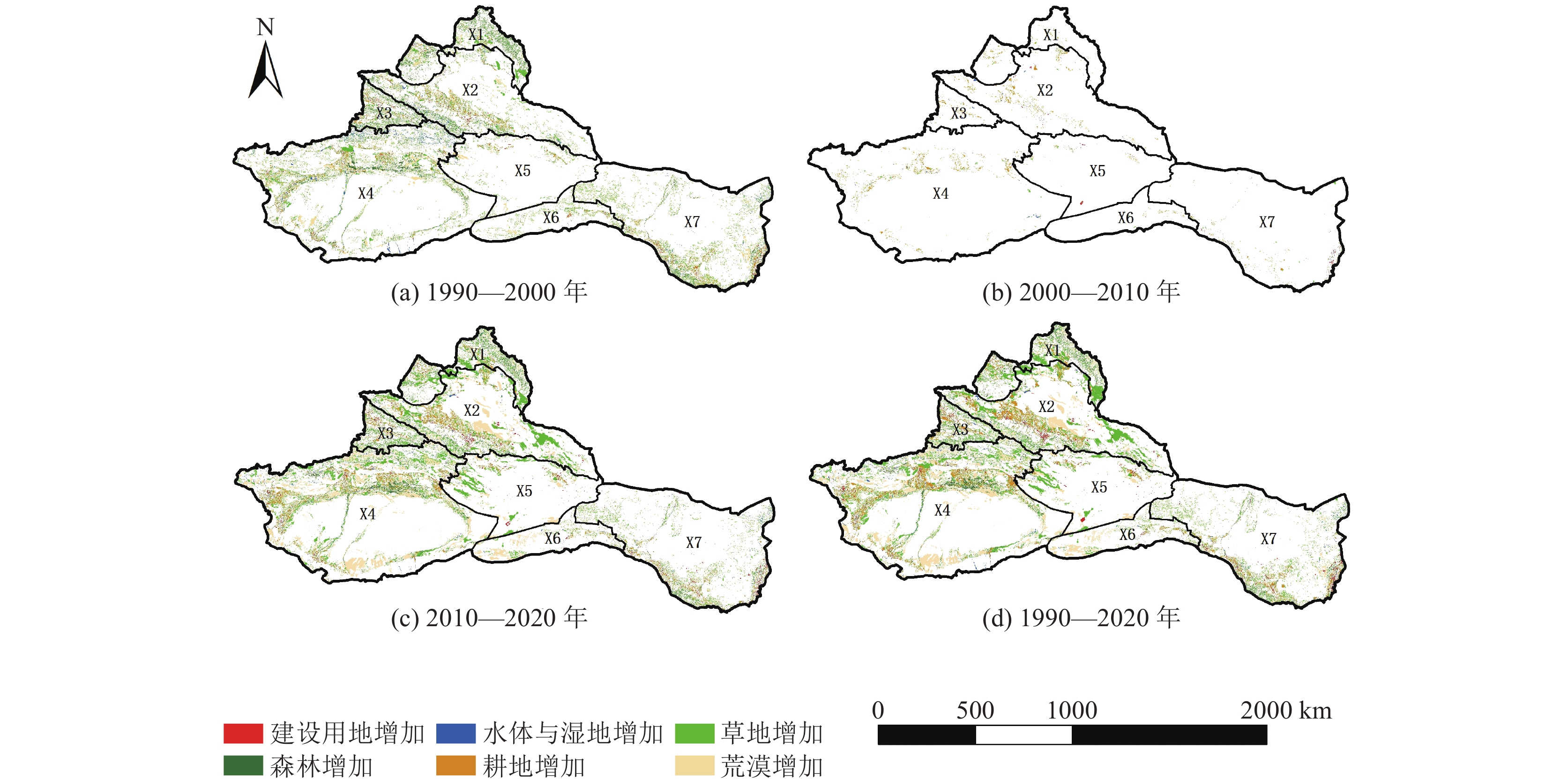
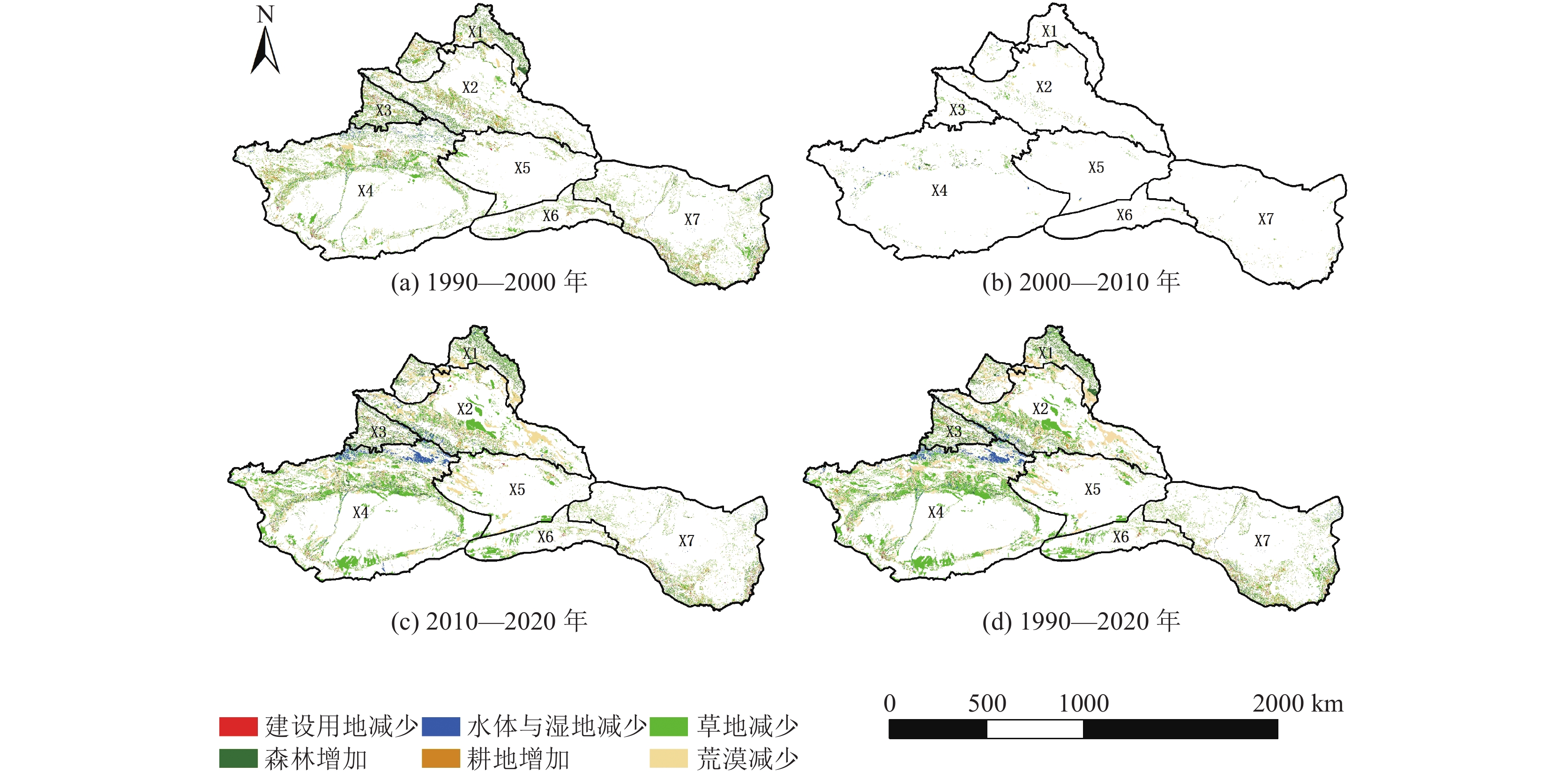
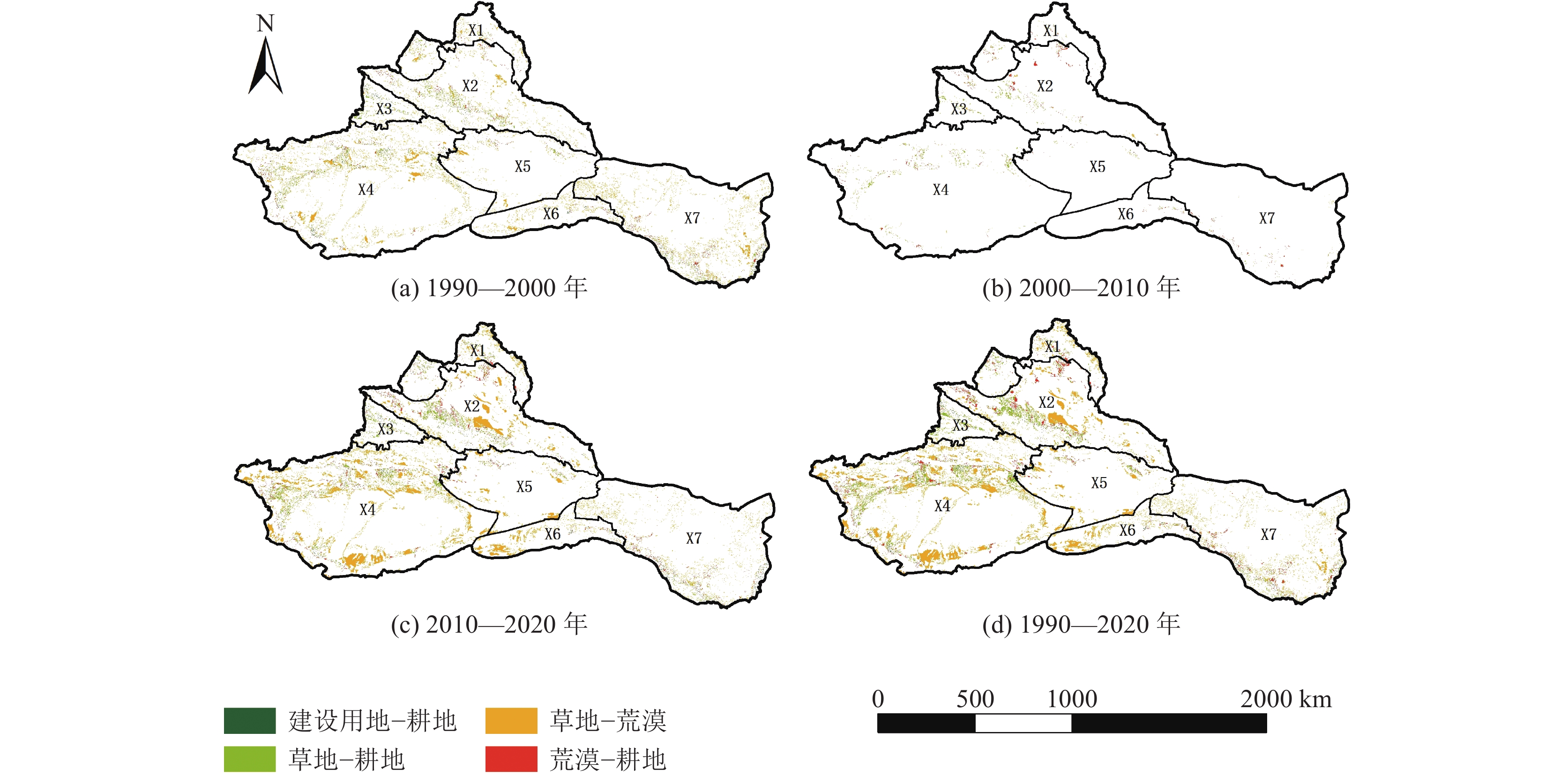
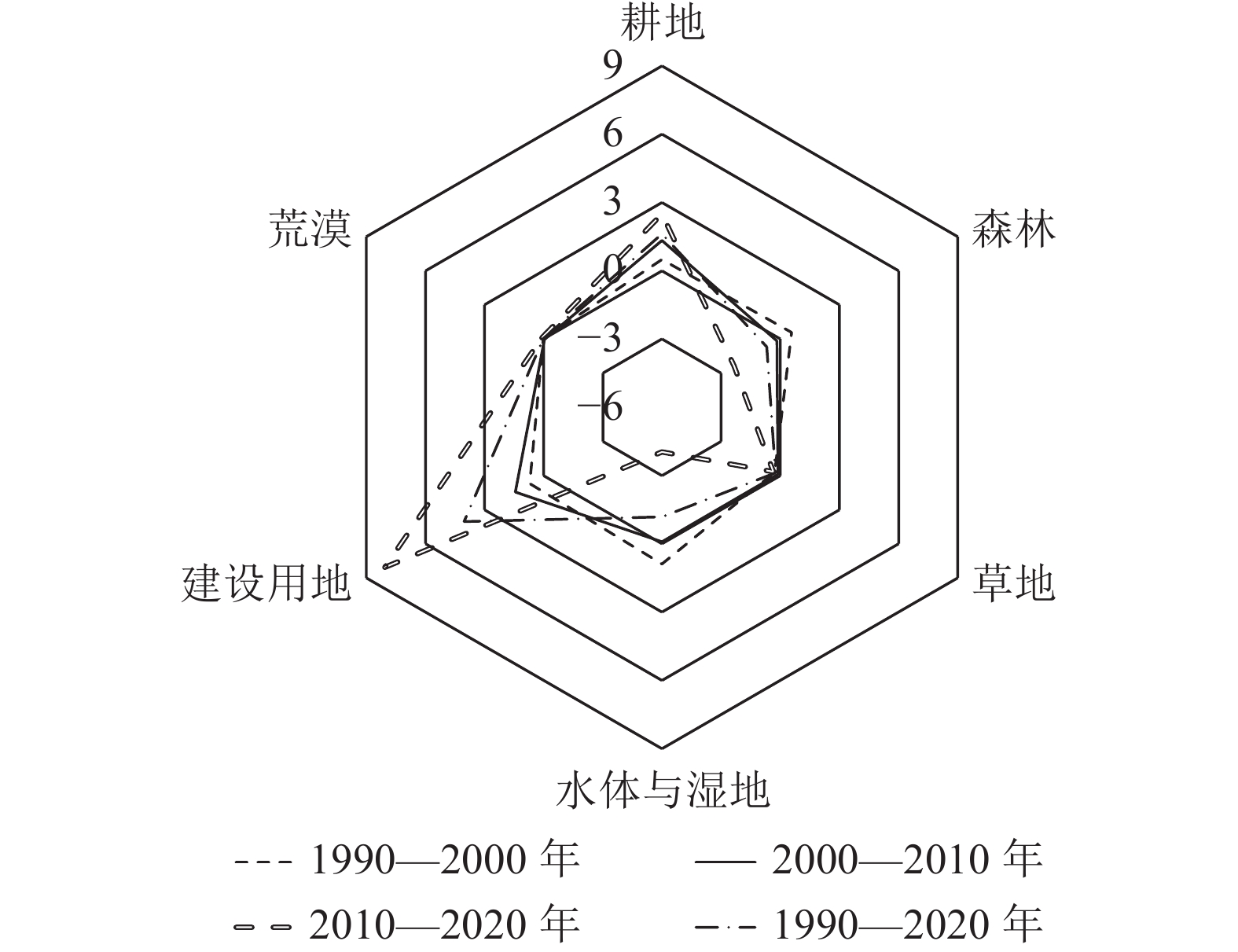
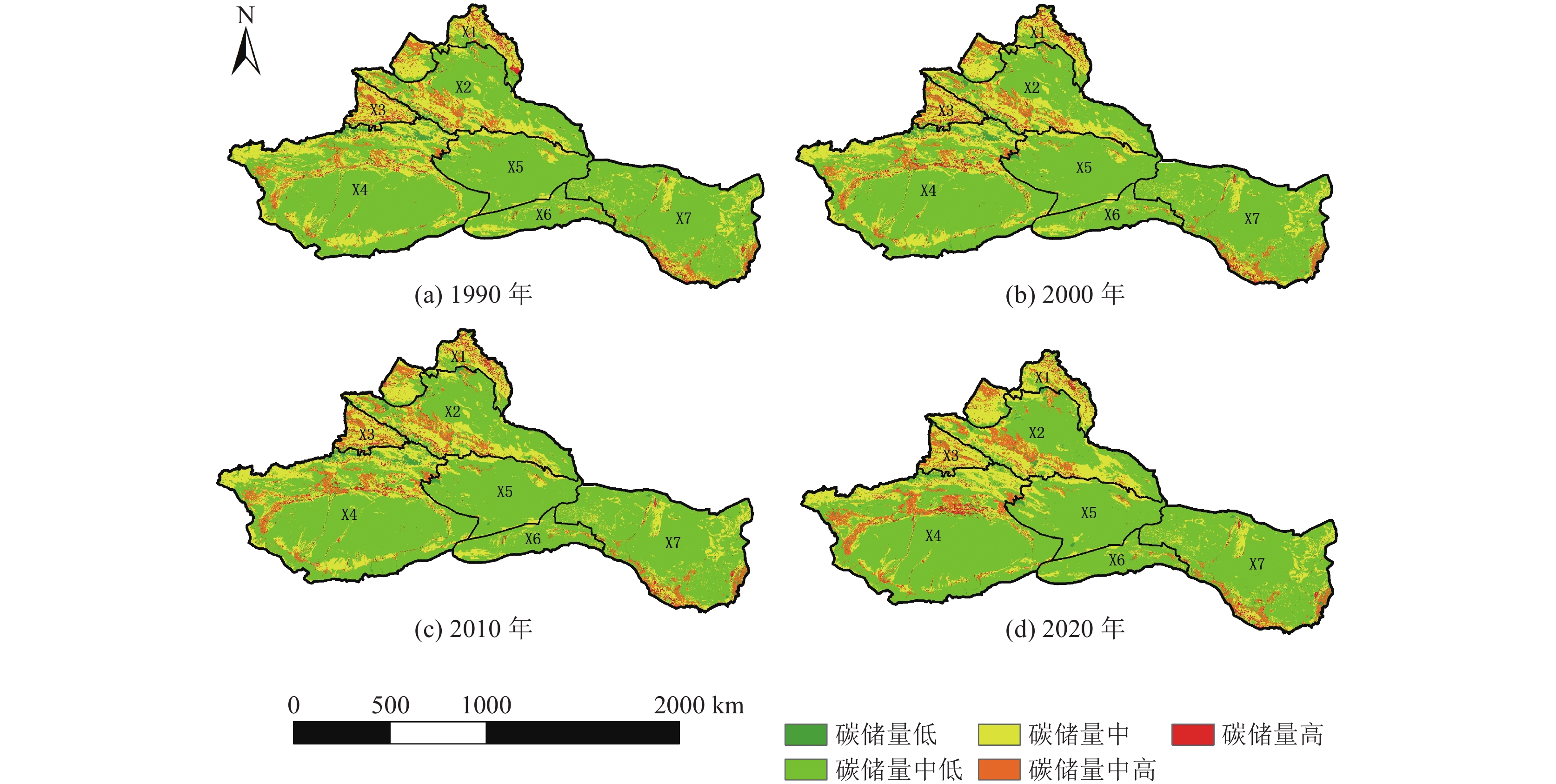
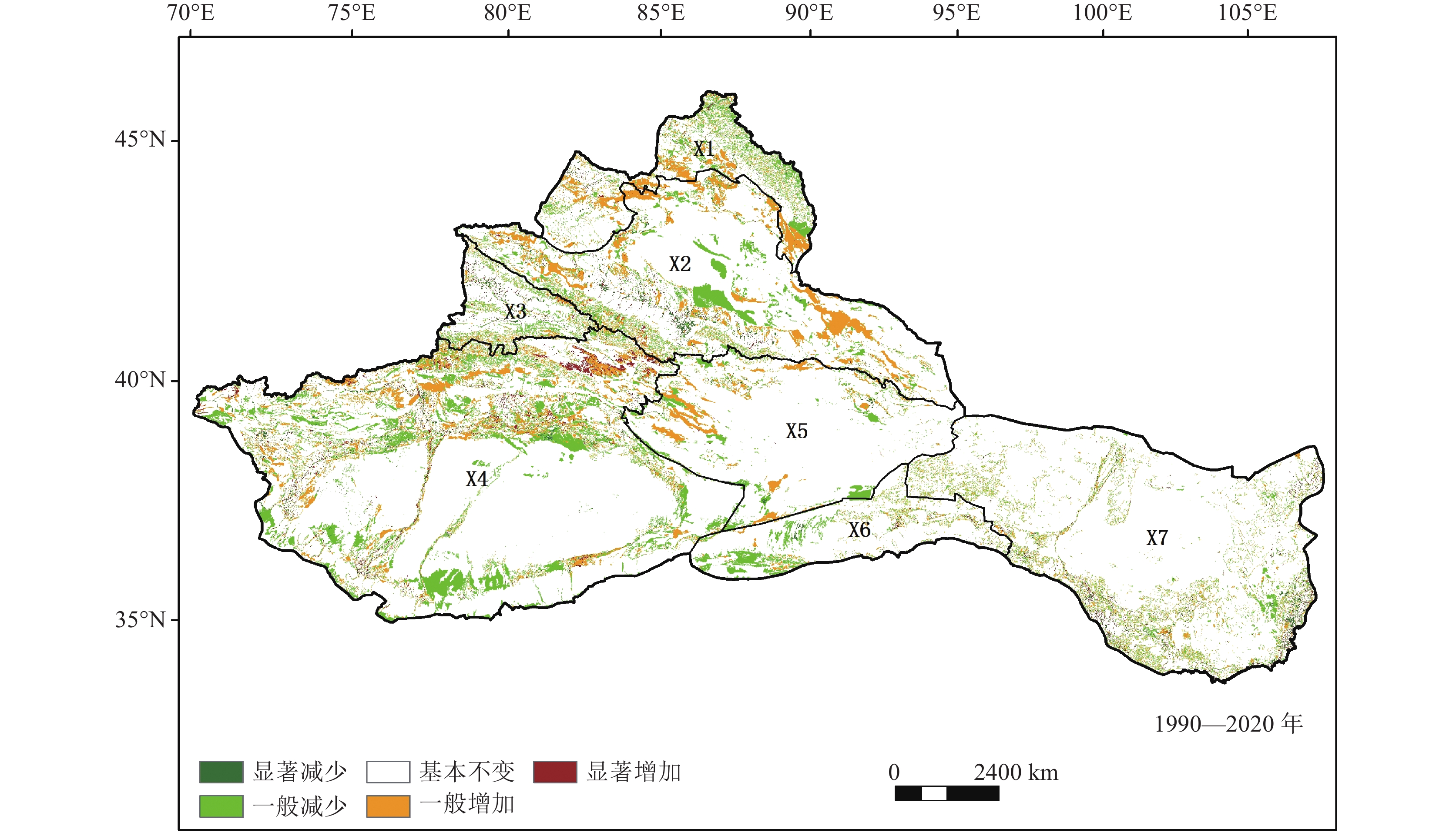
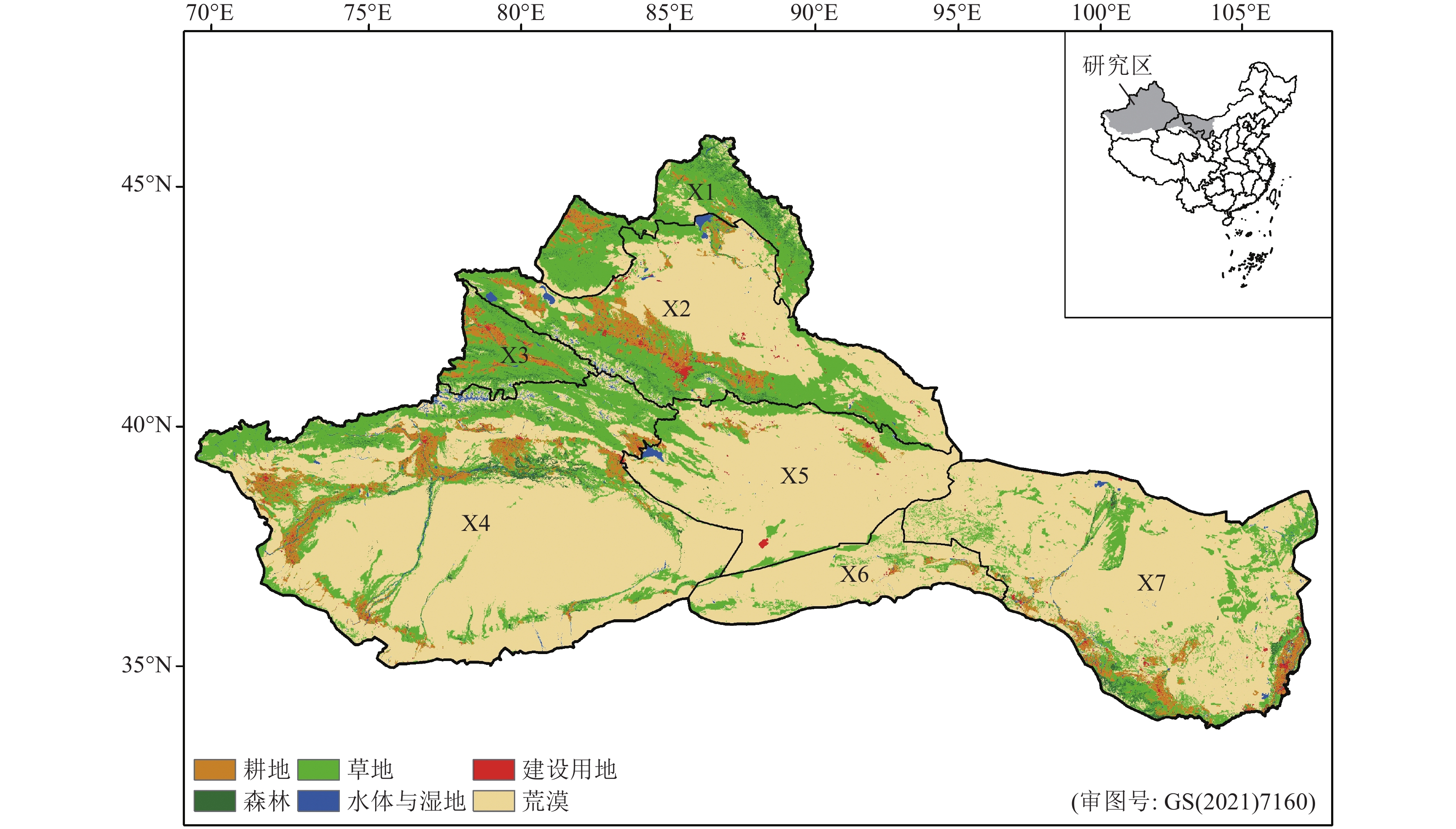
依据1990—2020年遥感影像、高程模型、植被、气象等数据,通过定量计算与定性分析相结合的区划分析,获取西北内陆荒漠资源大区的自然资源综合区划。根据西北内陆荒漠资源大区气候因子对全国水平下不同土地类型的碳密度进行修正,获取西部干旱区碳密度数据,利用InVEST模型,分析1990—2020年土地利用变化对碳储量的影响。结果表明:①近30 a来该研究区以草地退化为主,耕地和荒漠是草地主要转出的类型,其中2010—2020年土地利用类型变化显著;②研究区碳储量呈现西多东少的空间分布,其中西部阿尔泰山与塔城盆地温带草原亚区和伊犁盆地温带草原亚区由于草地面积较丰富而碳储量较高;③1990—2020年西北内陆荒漠资源大区的碳储量总体呈波动下降趋势,土地利用类型的转化引起碳储量净减少1.86×10⁸ t,其中2000年和2020年研究区大量草地转化为荒漠,使土壤碳储量明显下降,固碳潜力有所下降。本次对西北内陆荒漠资源大区土地利用对生态系统碳储量时空变化的评估,有助于判断生态系统功能的转化趋势,为生态系统调控和促进该地区低碳可持续发展提供参考。
Abstract:Based on remote sensing images, elevation models, vegetation and meteorological data from 1990 to 2020, the comprehensive regionalization of natural resources in northwest inland desert resource region was obtained by means of regionalization analysis combining quantitative calculation and qualitative analysis. According to the climate factors in the northwest inland desert resource region, the carbon density of different land types under the national level was revised to obtain the carbon density data of the western arid region. Based on the Integrated Valuation of Ecosystem Services and Tradeoffs (InVEST) model, we analyzed the effects of land use change on carbon stocks from 1990 to 2020. The results showed that :① In recent 30 years, the grassland in this study area was mainly degraded, and the grassland was mainly transformed into cultivated land and desert, and the land use type changed significantly from 2010 to 2020.② The spatial distribution of carbon storage in the study area is more in the west and less in the east. The grassland in Altai and Tacheng basin temperate grassland subregion and Yili Basin temperate grassland subregion are rich, so the carbon storage content is high.③ From 1990 to 2020, the carbon storage in the northwest inland desert resource region showed a decreasing trend. The conversion of land use type resulted a net reduction of carbon storage of 1.86×10⁸ tons. In 2000 and 2020, a large amount of grassland in the study area was transformed into desert, which significantly reduced soil carbon storage and carbon sequestration potential. This study evaluated the temporal and spatial changes of ecosystem carbon storage by land use in the northwest inland desert resource region, which is helpful to judge the transformation trend of ecosystem function and provide reference for ecosystem regulation and promoting low-carbon sustainable development in this region.
-
Key words:
- land use change /
- ecosystem carbon storage /
- InVEST model /
- Northwest China
-

-
表 1 不同土地类型的碳密度
Table 1. Carbon density of different land types
t/hm2 土地利用类型 地上生物量 地下生物量 土壤有机质 死亡有机质 耕地 4.22 5.01 89.94 0 森林 44.95 13.27 126.59 0 草地 0.71 6.24 88.69 0 水体与湿地 0.93 0.66 0 0 建设用地 3.29 2.11 0 0 荒漠 0.66 1.26 45.26 0  下载: 导出CSV
表 2 西北内陆荒漠资源大区碳密度
Table 2. Carbon density of the northwest inland desert resource region
t/hm2 土地类型 地上生物量碳密度 地下生物量碳密度 土壤碳密度 1990 2000 2010 2020 1990 2000 2010 2020 1990 2000 2010 2020 耕地 1.15 1.14 1.12 1.14 1.36 1.35 1.33 1.36 50.72 49.42 49.66 49.40 森林 12.22 12.13 11.90 12.18 3.61 3.58 3.51 3.60 71.39 69.55 69.89 69.53 草地 0.19 0.19 0.19 0.19 1.70 1.68 1.65 1.69 50.02 48.73 48.97 48.71 水体与湿地 0.25 0.25 0.25 0.25 0.18 0.18 0.17 0.18 0.00 0.00 0.00 0.00 建设用地 0.89 0.89 0.87 0.89 0.57 0.57 0.56 0.57 0.00 0.00 0.00 0.00 荒漠 0.18 0.18 0.17 0.18 0.34 0.34 0.33 0.34 25.52 24.87 24.99 24.86
下载: 导出CSV
表 3 1990—2020年西北内陆荒漠资源大区土地利用转移矩阵
Table 3. Land use transfer matrix of the northwest inland desert resource region from 1990 to 2020
土地类型 转移面积/km2 1990年面积/km2 草地 耕地 荒漠 建设用地 森林 水体与湿地 草地 294900.47 32045.29 103545.79 2343.19 15782.08 3503.37 452120.19 耕地 8914.81 55082.84 2626.27 4618.32 1454.18 1042.61 73739.02 荒漠 86651.42 15592.15 1069950.29 3232.06 2660.10 3804.09 1181890.10 建设用地 457.78 2720.58 474.95 1733.45 109.90 79.37 5576.03 森林 21618.14 2949.27 3468.69 248.60 12595.60 562.96 41443.25 水体与湿地 6223.33 1197.67 10896.87 161.85 389.08 8735.54 27604.33 2020年面积/km2 418765.95 109587.80 1190962.86 12337.46 32990.93 17727.93 1782372.92
下载: 导出CSV
表 4 近30 a西北内陆荒漠大区主要土地类型转变下的碳储量变化
Table 4. Carbon storage changes under the change of main land types in the inland desert region of Northwest China in recent 30 years
阶 段 土地类型转化 面积/km2 生物碳储量变化/104 t 土壤碳储量变化/104 t 总碳储量变化/104 t 1990—2000年 草地—耕地 15248.65 91.49 −91.49 0 草地—荒漠 53042.32 −726.68 −13340.14 −14066.82 建设用地—耕地 2748.80 28.31 1358.46 1386.77 荒漠—耕地 6105.24 120.27 1459.15 1579.42 2000—2010年 草地—耕地 6576.00 38.14 61.56 99.70 草地—荒漠 601.00 −8.23 −142.68 −150.91 建设用地—耕地 17.00 0.17 8.44 8.61 荒漠—耕地 3859.00 74.48 956.65 1031.13 2010—2020年 草地—耕地 21994.25 145.16 94.58 239.74 草地—荒漠 92004.14 −1214.45 −22182.20 −23396.65 建设用地—耕地 2755.13 29.48 1361.03 1390.51 荒漠—耕地 11044.82 220.90 2696.04 2916.94
下载: 导出CSV
-
[1] Houghton R A, Nassikas A A. 2017. Global and regional fluxes of carbon from land use and land cover change 1850 —2015[J]. Global Biogeochemical Cycles, 3(31): 456−472.
[2] Kalantaria Z, Ferreirab C S S, Pagea J, et al. 2019, Meeting sustainable development challenges in growing cities: Coupled social−ecological systems modeling of land use and water changes[J]. Journal of Environmental Management, 1(245): 471−480.
[3] Liu G, Wei M, Yang Z, et al. 2023. Relationship between spatio−temporal evolution of soil pH and geological environment/surface cover in the eastern Nenjiang River Basin of Northeast China during the past 30 years[J]. China Geology, 6(3): 369−382.
[4] Potter C S, Randerson J T, Field C B, et al. 1993. Terrestrial ecosystem production: A process model based on global Satellite and suface data[J]. Global Biogeochemical Cycles, 7(4): 811−841.
[5] Tang X, Zhao X, Bai Y, et al. 2018. Carbon pools in China’s terrestrial ecosystems: New estimates based on an intensive field survey[J]. Proceedings of the National Academy of Sciences of the United States of America, 16(115): 4021−4026.
[6] Zhou J, Zhao Y, Huang P, et al. 2020. Impacts of ecological restoration projects on the ecosystem carbon storage of inland river ba sin in arid area, China[J]. Ecological Indicators, (118): 106803.
[7] Zhu G, Qiu D, Zhang Z, et al. 2021. Land−use changes lead to a decrease in carbon storage in arid region, China[J]. Ecological Indicators, (127): 107770.
[8] 阿米娜木·艾力, 常顺利, 张毓涛, 等. 2014. 天山云杉森林土壤有机碳沿海拔的分布规律及其影响因素[J]. 生态学报, 34(7): 1626−1634.
[9] 陈光水, 杨玉盛, 刘乐中, 等. 2007. 森林地下碳分配(TBCA)研究进展[J]. 亚热带资源与环境学报, (1): 34−42. doi: 10.3969/j.issn.1673-7105.2007.01.005
[10] 陈宁, 辛存林, 唐道斌, 等. 2023. 中国西北地区多情景土地利用优化与碳储量评估[J]. 环境科学, 44(8): 4655−4665.
[11] 揣小伟, 黄贤金, 郑泽庆, 等. 2011. 江苏省土地利用变化对陆地生态系统碳储量的影响[J]. 资源科学, 33(10): 1932−1939.
[12] 冯益明, 姚爱冬, 姜丽娜. 2014. CASA模型的改进及在干旱区生态系统NPP估算中的应用[J]. 干旱区资源与环境, 28(8): 39−43.
[13] 高扬, 何念鹏, 汪亚峰. 2013. 生态系统固碳特征及其研究进展[J]. 自然资源学报, 28(7): 1264−1274. doi: 10.11849/zrzyxb.2013.07.018
[14] 葛全胜, 戴君虎, 何凡能, 等. 2008. 过去300年中国土地利用、土地覆被变化与碳循环研究[J]. 中国科学(D辑), (2): 197−210.
[15] 黄卉. 2015. 基于InVEST模型的土地利用变化与碳储量研究[D]. 中国地质大学(北京)硕士学位论文.
[16] 黄莉, 刘晓煌, 刘玖芬, 等. 2021. 长时间尺度下自然资源动态综合区划理论与实践研究——以青藏高原为例[J]. 中国地质调查, 8(2): 109−117.
[17] 赖明, 吴淑玉, 张海燕, 等. 2021. 基于综合区划的中国西南地区自然资源动态变化特征分析[J]. 中国地质调查, 8(2): 83−91.
[18] 李传华, 曹红娟, 范也平, 等. 2019. 基于校正的CASA模型NPP遥感估算及分析——以河西走廊为例[J]. 生态学报, 39(5): 1616−1626.
[19] 李勇, 高岚. 2021. 中国“碳中和”目标的实现路径与模式选择[J]. 华南农业大学学报(社会科学版), 20(5): 77−93.
[20] 廖艳, 崔军, 杨忠芳, 等. 2012. 三江平原典型土地利用类型土壤呼吸强度对温度的敏感性[J]. 地质通报, 31(1): 164−171. doi: 10.3969/j.issn.1671-2552.2012.01.021
[21] 刘国华, 傅伯杰, 方精云. 2000. 中国森林碳动态及其对全球碳平衡的贡献[J]. 生态学报, (5): 733−740. doi: 10.3321/j.issn:1000-0933.2000.05.004
[22] 刘海霞, 马立志. 2016. 西北地区生态环境问题及其治理路径[J]. 实事求是, (4): 50−54. doi: 10.3969/j.issn.1003-4641.2016.04.10
[23] 刘建泉, 李进军, 郝虎, 等. 2017. 祁连山青海云杉林生物量与碳储量及其影响因素分析[J]. 现代农业科技, (12): 140−143. doi: 10.3969/j.issn.1007-5739.2017.12.088
[24] 刘晓娟, 黎夏, 梁迅, 等. 2019. 基于FLUS−InVEST模型的中国未来土地利用变化及其对碳储量影响的模拟[J]. 热带地理, 39(3): 397−409.
[25] 柳梅英, 包安明, 陈曦, 等. 2010. 近30年玛纳斯河流域土地利用/覆被变化对植被碳储量的影响[J]. 自然资源学报, 25(6): 926−938. doi: 10.11849/zrzyxb.2010.06.005
[26] 卢雅焱, 徐晓亮, 李基才, 等. 2022. 基于InVEST模型的新疆天山碳储量时空演变研究[J]. 干旱区研究, 39(6): 1896−1906.
[27] 马晓哲, 王铮. 2015. 土地利用变化对区域碳源汇的影响研究进展[J]. 生态学报, 35(17): 5898−5907.
[28] 曲福田, 卢娜, 冯淑怡. 2011. 土地利用变化对碳排放的影响[J]. 中国人口·资源与环境, 21(10): 76−83. doi: 10.3969/j.issn.1002-2104.2011.10.012
[29] 石聪. 2012. 徐州侧柏人工林生态系统碳储量影响因素研究[D]. 南京林业大学硕士学位论文.
[30] 宋佳颖. 2021. 西北五省植被NDVI的时空变化及驱动力研究[D]. 西北师范大学硕士学位论文.
[31] 王绍强, 周成虎, 李克让, 等. 2000. 中国土壤有机碳库及空间分布特征分析[J]. 地理学报, (5): 533−544. doi: 10.11821/xb200005003
[32] 王文俊. 2019. 福建省土壤有机碳储量估算、时空分布特征及其影响因素[J]. 现代地质, 33(6): 1295−1305.
[33] 王效科, 冯宗炜, 欧阳志云. 2001. 中国森林生态系统的植物碳储量和碳密度研究[J]. 应用生态学报, (1): 13−16. doi: 10.3321/j.issn:1001-9332.2001.01.003
[34] 王秀兰, 包玉海. 1999. 土地利用动态变化研究方法探讨[J]. 地理科学进展, (1): 83−89.
[35] 谢立军, 白中科, 杨博宇, 等. 2023. 碳中和背景下国内外陆地生态系统碳汇评估方法研究进展[J]. 地学前缘, 30(2): 447−462.
[36] 辛晓平, 丁蕾, 程伟, 等. 2020. 北方草地及农牧交错区草地植被碳储量及其影响因素[J]. 中国农业科学, 53(13): 2757−2768. doi: 10.3864/j.issn.0578-1752.2020.13.022
[37] 徐丽, 何念鹏, 于贵瑞. 2019. 2010s中国陆地生态系统碳密度数据集[J]. 中国科学数据(中英文网络版), 4(1): 90−96.
[38] 杨园园, 戴尔阜, 付华. 2012. 基于InVEST模型的生态系统服务功能价值评估研究框架[J]. 首都师范大学学报(自然科学版), 33(3): 41−47.
[39] 翟羽娟, 张艳红, 姜琦刚, 等. 2022. 吉林省西部农牧交错区“三生空间”时空演变[J]. 吉林大学学报(地球科学版), 52(3): 1016−1026.
[40] 张楚强, 向洋, 方婷, 等. 2022. LUCC影响下太原市生态系统碳储量时空变化及预测[J]. 安全与环境工程, 29(6): 248−258.
[41] 张峰, 周广胜, 王玉辉. 2008. 基于CASA模型的内蒙古典型草原植被净初级生产力动态模拟[J]. 植物生态学报, (4): 786−797. doi: 10.3773/j.issn.1005-264x.2008.04.007
[42] 张海燕, 樊江文, 黄麟, 等. 2020. 中国自然资源综合区划理论研究与技术方案[J]. 资源科学, 42(10): 1870−1882.
[43] 张杰, 李敏, 敖子强, 等. 2018. 中国西部干旱区土壤有机碳储量估算[J]. 干旱区资源与环境, 32(9): 132−137.
[44] 张子凡, 张海燕, 刘晓煌, 等. 2021. 华北地区自然资源综合区划的动态变化特征[J]. 中国地质调查, 8(2): 92−99.
[45] 郑艺文, 张海燕, 刘晓洁, 等. 2021. 1990—2018年东北地区综合区划下自然资源动态变化特征分析[J]. 中国地质调查, 8(2): 100−108.
[46] 周涛, 史培军. 2006. 土地利用变化对中国土壤碳储量变化的间接影响[J]. 地球科学进展, (2): 138−143. doi: 10.3321/j.issn:1001-8166.2006.02.004
-


图(10)
表(4)
计量
- 文章访问数: 981
- PDF下载数: 55
- 施引文献: 0