

Classification framework and empirical study of Earth Critical Zone at small-scale: A case study of Xixia County, Henan Province
-
摘要:
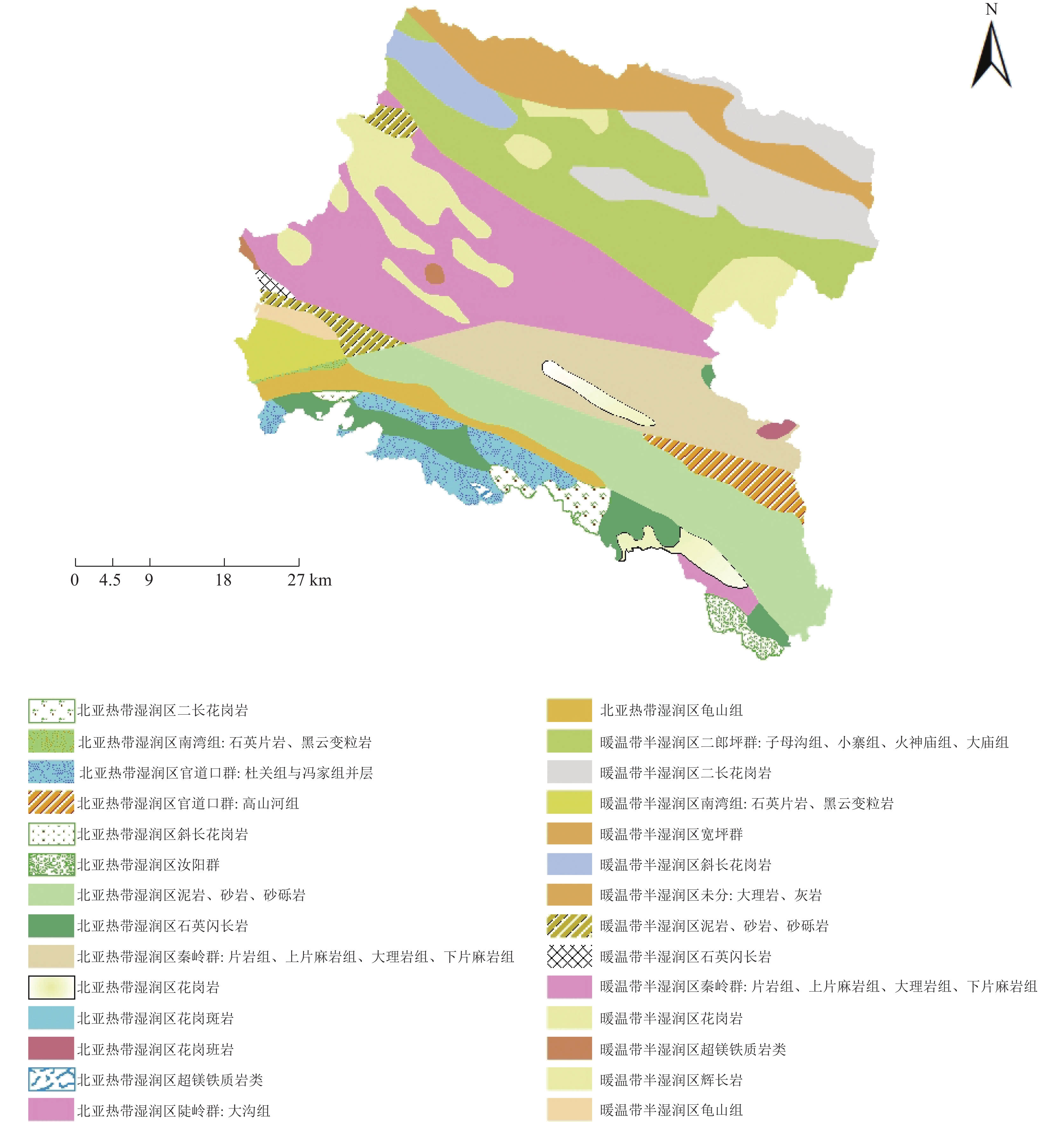
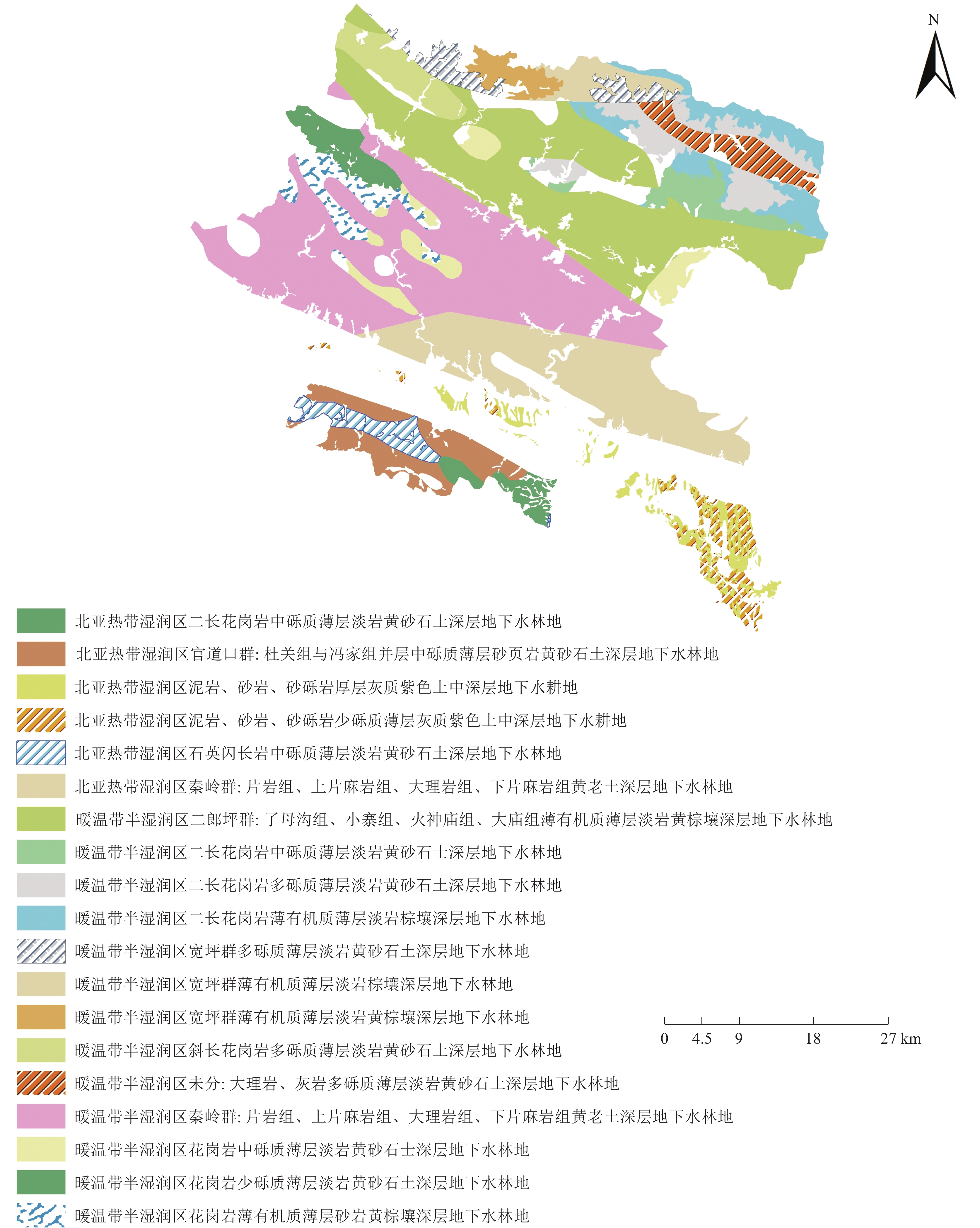
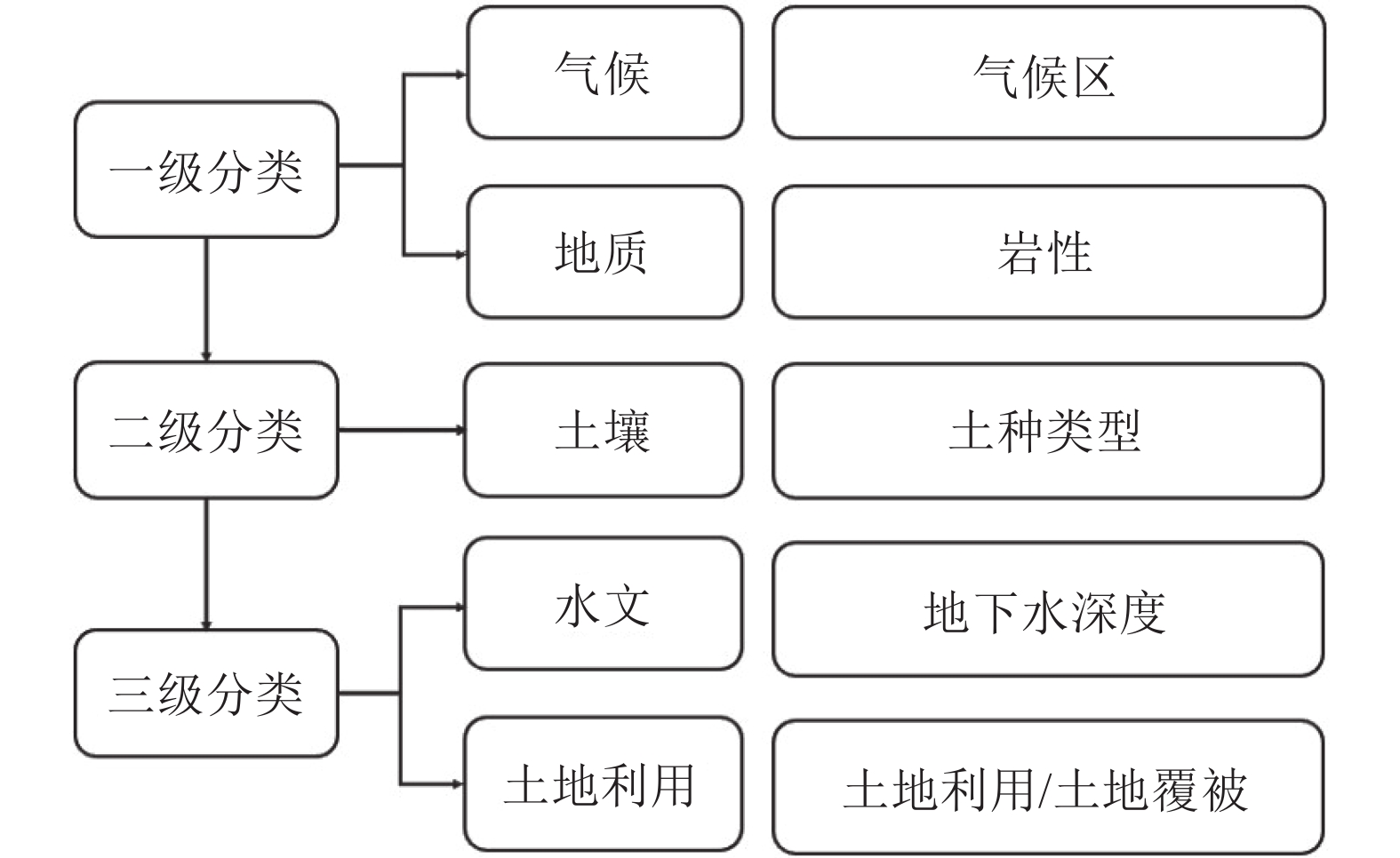
地球关键带分类有助于认知关键带的空间布局,了解其发生和演化的区域差异性,并可以作为观测和调查关键带的基础。为了延续大尺度地球关键带分类,在分析关键带组成要素的基础上,采用多层级划分法构建了一套小尺度关键带分类的框架,并在GIS中以图层叠置法对河南省西峡县做了实证研究。建立了一套涵盖分类原则、分类指标的多层级地球关键带分类框架,并将西峡县地球关键带划分为28 个一级类型单元,246个二级类型单元和722个三级类型单元。这种划分可以提高对地球系统科学的整体认知,对小尺度地球关键带的科学研究和自然资源综合管理也具有一定的参考意义。
Abstract:The classification of Earth Critical Zone is helpful to cognize the spatial distribution and understand the regional differences in the occurrence and evolution of Critical Zone. Besides, it is the basis for the observation and investigation of Critical Zone. To further study the existing large−scale Critical Zone classification, this study constructed a set of small−scale Critical Zone classification frameworks using a multi−level classification method. It made an empirical study of Xixia County in Henan Province by using the map overlay method in GIS. The research results showed a group of multi−level classification frameworks covering classification principles and indexes in the mountainous area, and the Critical Zone of Xixia County was divided into 28 first−level types, 246 second−level types, and 722 third−level types. This classification can improve the overall understanding of earth system science. It also has specific reference significance for scientific research and the comprehensive management of natural resources in the critical zones of the earth at different scales.
-
Key words:
- Earth Critical Zone /
- classification unit /
- county level /
- Xixia County /
- Henan Province
-

-
表 1 面积占比前65%的地球关键带三级类型区划分结果
Table 1. Results of the classification of the third-level of Earth Critical Zone with the top 65% area
序号 地球关键带三级类型名称 地理位置 面积/km2 占比 1 暖温带半湿润区秦岭群:片岩组、上片麻岩组、大理岩组、下片麻岩组−黄老土−深层地下水林地 西南部 575.28 16.70% 2 暖温带半湿润区二郎坪群:子母沟组、小寨组、火神庙组、大庙组−薄有机质薄层淡岩黄棕壤−深层地下水林地 北部 479.80 13.93% 3 北亚热带湿润区秦岭群:片岩组、上片麻岩组、大理岩组、下片麻岩组−黄老土−深层地下水林地 东南部 287.59 8.35% 4 暖温带半湿润区二长花岗岩−薄有机质薄层淡岩棕壤−深层地下水林地 北部 104.08 3.02% 5 北亚热带湿润区官道口群:杜关组与冯家组并层−中砾质薄层砂页岩黄砂石土−深层地下水林地 南部 98.97 2.87% 6 暖温带半湿润区二长花岗岩−多砾质薄层淡岩黄砂石土−深层地下水林地 东北部 96.81 2.81% 7 暖温带半湿润区花岗岩−中砾质薄层淡岩黄砂石土−深层地下水林地 中部 71.71 2.08% 8 暖温带半湿润区斜长花岗岩−多砾质薄层淡岩黄砂石土−深层地下水林地 西北部 62.69 1.82% 9 暖温带半湿润区二长花岗岩−中砾质薄层淡岩黄砂石土−深层地下水林地 东北部 58.46 1.70% 10 暖温带半湿润区未分:大理岩、灰岩−多砾质薄层淡岩黄砂石土−深层地下水林地 东北部 57.82 1.68% 11 北亚热带湿润区泥岩、砂岩、砂砾岩−厚层灰质紫色土−中深层地下水耕地 东南部 56.79 1.65% 12 暖温带半湿润区花岗岩−薄有机质薄层砂岩黄棕壤−深层地下水林地 西南部 54.83 1.59% 13 暖温带半湿润区花岗岩−少砾质薄层淡岩黄砂石土−深层地下水林地 中西部 49.45 1.44% 14 北亚热带湿润区泥岩、砂岩、砂砾岩−少砾质薄层灰质紫色土−中深层地下水耕地 南部 46.51 1.35% 15 暖温带半湿润区宽坪群−多砾质薄层淡岩黄砂石土−深层地下水林地 北部 45.45 1.32% 16 暖温带半湿润区宽坪群−薄有机质薄层淡岩棕壤−深层地下水林地 北部 42.74 1.24% 17 北亚热带湿润区石英闪长岩−中砾质薄层淡岩黄砂石土−深层地下水林地 南部 41.93 1.22% 18 暖温带半湿润区宽坪群薄有机质−薄层淡岩黄棕壤−深层地下水林地 北部 34.06 0.99% 19 北亚热带湿润区二长花岗岩−中砾质薄层淡岩黄砂石土−深层地下水林地 南部 30.96 0.90%  下载: 导出CSV
-
[1] An Z S, Fu C B. 2001. The progess in global change science[J]. Advance in Earth Sciences, (5): 671−680(in Chinese with English abstract).
[2] Banwart S A, Chorover J, Gaillardet J, et al. 2013. Sustaining Earth’s critical zone basic science and interdisciplinary solutions for global challenges[M]. Sheffield: University of Sheffield.
[3] Banwart S, Bernasconi S M, Bloem J, et al. 2011. Soil processes and functions in critical zone observatories: Hypotheses and experimental design[J]. Vadose Zone Journal, 10(3): 974−987. doi: 10.2136/vzj2010.0136
[4] Brantley S L, Goldhaber M B, Ragnarsdottir K V. 2007. Crossing disciplines and scales to understand the critical zone[J]. Elements, 3(5): 307−314. doi: 10.2113/gselements.3.5.307
[5] Brantley S L, White T S, White A F. 2005. Frontiers in exploration of the critical zone: Report of a workshop sponsored by the NSF Newark [R].
[6] Cao J H, Yang H, Zhang C L, et al. 2018. Characteristics of structure and material cycling of the karst critical zone in Southwest China[J]. Geological Survey of China, 5(5): 1−12(in Chinese with English abstract).
[7] Giardino J R, Houser C. 2015. Principles and dynamics of the critical zone [M]. Elsevier.
[8] Guo Z J. 2012. A review on the Paleozoic tectonic evolution of northern Xinjiang and a discussion on the important role of geological maps in tectonic study[J]. Geological Bulletin of China, 31(7): 1054−1060(in Chinese with English abstract).
[9] Hjort J, Gordon J E, Gray M, et al. 2015. Why geodiversity matters in valuing nature's stage[J]. Conservation Biology, 29(3): 630−639. doi: 10.1111/cobi.12510
[10] Hu J, Hu J J, Lü Y H. 2021, Spatial variation of the relationship between annual runoff and sediment yield and land uses based on the regional critical zone differentiation in the Loss Plateau [J]. Acta Ecologica Sinica, 41(16) : 6417−6429(in Chinese with English abstract).
[11] Keith D A. 2011. Relationships between geodiversity and vegetation in southeastern Australia[C]//Proceedings of the Linnean Society of New South Wales: 5−26.
[12] Li L, Maher K, Navarre−Sitchler A, et al. 2017. Expanding the role of reactive transport models in critical zone processes[J]. Earth−Science Reviews, 165: 280−301. doi: 10.1016/j.earscirev.2016.09.001
[13] Li X L, Wu K N, Feng Z, et al. 2022. Research progress of land surface system classification: From land type to Earth's critical zone type[J]. Progress in Geography, 41(3): 531−542 (in Chinese with English abstract). doi: 10.18306/dlkxjz.2022.03.015
[14] Liu L M. 2002. Land resource management[M]. Beijing: China Agricultural University Press (in Chinese).
[15] Liu Y N, Wu K N, Li X L, et al. 2022. Classification of land types at provincial level based on the goal of black land protection: A case study of Heilongjiang Province[J]. Scientia Geographica Sinica, 42(8): 1348−1359 (in Chinese with English abstract).
[16] Liu Y S. 2020. Modern human−earth relationship and human−earth system science[J]. Scientia Geographica Sinica. 40(8): 1221−1234 (in Chinese with English abstract).
[17] Luo Z B, Fan J, Shao M A. 2022. Progresses of weathered bedrock ecohydrology in the Earth’s critical zone[J]. Chinese Science Bulletin, 67: 3311−3323 (in Chinese with English abstract). doi: 10.1360/TB-2022-0046
[18] Lü Y H, Hu J, Fu B J, et al. 2019. A framework for the regional critical zone classification: The case of the Chinese Loess Plateau[J]. National Science Review, 6(1): 14−18. doi: 10.1093/nsr/nwy147
[19] Ma W J, Min L L, Qi Y Q, et al. 2022. Classification of agricultural critical zones in the North China Plain[J]. Chinese Journal of Eco−Agriculture, 30(5): 769−778 (in Chinese with English abstract).
[20] National Research Council. 2001. Basic research opportunities in Earth science[M]. Washington DC: National Academy Press.
[21] Pu J B. 2022. Earth's critical zone and karst critical zone: Structure, characteristic and bottom boundary[J]. Bulletin of Geological Science and Technology, 41(5): 230−241 (in Chinese with English abstract).
[22] Rasmussen C, Troch P A, Chorover J, et al. 2011. An open system framework for integrating critical zone structure and function[J]. Biogeochemistry, 102(1): 15−29.
[23] Richter D B, Billings S A. 2015. ‘One physical system’: Tansley's ecosystem as Earth's critical zone[J]. New Phytologist, 206(3): 900−912. doi: 10.1111/nph.13338
[24] Salve R, Rempe D M, Dietrich W E. 2012. Rain, rock moisture dynamics, and the rapid response of perched groundwater in weathered, fractured argillite underlying a steep hillslope[J]. Water Resources Research, 48(11): 1−25.
[25] Scarpone C, Schmidt M G, Bulmer C E, et al. 2016. Modelling soil thickness in the critical zone for Southern British Columbia[J]. Geoderma, 282: 59−69. doi: 10.1016/j.geoderma.2016.07.012
[26] Sullivan P L, Wymore A S, McDowell M. 2017. New Opportunities for Critical Zone Science[R]. Arlington, VA: 2017 CZO Arlington Meeting White Booklet.
[27] Shi J P, Song G., 2016. Soil type database of China: A nationwide soil dataset based on the Second National Soil Survey[J]. China Scientific Data, (2): 1−12(in Chinese with English abstract).
[28] Wang J G, Yang L Z, Shan Y H, 2001. Application of fuzzy mathematics to soil quality evaluation[J]. Acta Pedologica Sinica, (2): 176−183(in Chinese with English abstract).
[29] Yang J F, Zhang C G. 2014. Earth’s critical zone: A holistic framework for geo−environmental researches[J]. Hydrogeology & Engineering Geology, 41(3): 98−104,110(in Chinese with English abstract).
[30] Yang S H, Zhang G L. 2021. What are Earth's key zones[J]. Science, 73(5): 33−36,4 (in Chinese).
[31] Zhang G L, Zhu Y G, Shao M A. 2019. Understanding sustainability of soil and water resources in a critical zone perspective[J]. Science China Earth Sciences, 62: 1716−1718 (in Chinese with English abstract). doi: 10.1007/s11430-019-9368-7
[32] Zhang G L, Song X D, Wu K N. 2021. A classification scheme for Earth’s critical zones and its application in China[J]. Science China Earth Sciences, 64(10): 1709−1720 (in Chinese with English abstract). doi: 10.1007/s11430-020-9798-2
[33] Zheng J Y, Yin Y H, Li B Y. 2010. A new scheme for climate regionalization in China[J]. Acta Geographica Sinica, 65(1): 3−12 (in Chinese with English abstract).
[34] Zheng J Y, Bian J J, Ge Q S, et al. 2013. The climate regionalization in China for 1951−1980 and 1981−2010[J], Geographical Research, 32(6): 987−997 (in Chinese with English abstract).
[35] Zhu Y G, Li G, Zhang G L, et al. 2015. Soil security: From Earth's critical zone to ecosystem services[J]. Acta Geographica Sinica, 70(12): 1859−1869 (in Chinese with English abstract).
[36] 安芷生, 符淙斌. 2001. 全球变化科学的进展[J]. 地球科学进展, (5): 671−680. doi: 10.3321/j.issn:1001-8166.2001.05.011
[37] 曹建华, 杨慧, 张春来, 等. 2018. 中国西南岩溶关键带结构与物质循环特征[J]. 中国地质调查, 5(5): 1−12.
[38] 郭召杰. 2012. 新疆北部大地构造研究中几个问题的评述——兼论地质图在区域构造研究中的重要意义[J]. 地质通报, 31(7): 1054−1060. doi: 10.3969/j.issn.1671-2552.2012.07.004
[39] 胡健, 胡金娇, 吕一河. 2021. 基于黄土高原关键带类型的土地利用与年径流产沙关系空间分异研究[J]. 生态学报, 41(16): 6417−6429.
[40] 李晓亮, 吴克宁, 冯喆, 等. 2022. 陆地表层系统分类研究进展——从土地类型到地球关键带类型[J]. 地理科学进展, 41(3): 531−542. doi: 10.18306/dlkxjz.2022.03.015
[41] 刘黎明. 2002. 土地资源学[M]. 北京: 中国农业大学出版社.
[42] 刘亚男, 吴克宁, 李晓亮, 等. 2022. 基于黑土地保护目标的省级尺度土地类型划分研究——以黑龙江省为例[J]. 地理科学, (8): 1348−1359.
[43] 刘彦随. 2020. 现代人地关系与人地系统科学[J]. 地理科学, 40(8): 1221−1234.
[44] 骆占斌, 樊军, 邵明安. 2022. 地球关键带基岩风化层生态水文研究进展[J]. 科学通报, 67(27): 3311−3323.
[45] 马婉君, 闵雷雷, 齐永青, 等. 2022. 华北平原农田关键带分类研究[J]. 中国生态农业学报(中英文), 30(5): 769−778. doi: 10.12357/cjea.20220042
[46] 蒲俊兵. 2022. 地球关键带与岩溶关键带: 结构、特征、底界[J]. 地质科技通报, 41(5): 230−241.
[47] 施建平, 宋歌. 2016. 中国土种数据库——基于第二次土壤普查的全国性土壤数据集[J]. 中国科学数据, (2): 1−12.
[48] 王建国, 杨林章, 单艳红. 2001. 模糊数学在土壤质量评价中的应用研究[J]. 土壤学报, (2): 176−183. doi: 10.3321/j.issn:0564-3929.2001.02.005
[49] 杨建锋, 张翠光. 2014. 地球关键带: 地质环境研究的新框架[J]. 水文地质工程地质, 41(3): 98−104,110.
[50] 杨顺华, 张甘霖. 2021. 什么是地球关键带[J]. 科学, 73(5): 33−36,4.
[51] 张甘霖, 朱永官, 邵明安. 2019. 地球关键带过程与水土资源可持续利用的机理[J]. 中国科学: 地球科学, 49(12): 1945−1947.
[52] 张甘霖, 宋效东, 吴克宁. 2021. 地球关键带分类方法与中国案例研 究[J]. 中国科学: 地球科学, 51(10): 1681−1692.
[53] 郑景云, 尹云鹤, 李炳元. 2010. 中国气候区划新方案[J]. 地理学报, 65(1): 3−12. doi: 10.11821/xb201001002
[54] 郑景云, 卞娟娟, 葛全胜, 等. 2013. 中国1951—1980年及1981— 2010年的气候区划[J]. 地理研究, 32(6): 987−997.
[55] 朱永官, 李刚, 张甘霖, 等. 2015. 土壤安全: 从地球关键带到生态系统服务[J]. 地理学报, 70(12): 1859−1869. doi: 10.11821/dlxb201512001
-

图(4)
表(1)
计量
- 文章访问数: 660
- PDF下载数: 85
- 施引文献: 0