

Research progress and prospect of soil hydrological processes in critical zone of the Loess Plateau
-
摘要:
地球关键带是21世纪地球科学的前沿和重点领域之一。黄土约占全球陆地面积的10%,中国的黄土高原是典型的地球关键带之一。土壤水文过程驱动着黄土高原关键带不同尺度的系列生物地球化学循环过程,决定土壤−植被−大气连续体的演化方向与可持续性。基于地球关键带“4M”研究框架,综述了黄土高原关键带土壤水文过程研究的热点与前沿,梳理了不同尺度土壤水文过程的观测方法与技术、模型模拟与填图、深层土壤干化管理等研究进展;在此基础上,围绕黄土高原关键带土壤水资源优化利用与生态系统服务功能提升,提出了全球气候变化和大规模人类活动共同影响下黄土高原关键带土壤水文过程的优化管理对策和建议,展望了黄土高原关键带土壤水文过程研究的未来趋势。以期深化黄土高原关键带研究的科学认知,促进地球关键带科学的发展,为黄土高原自然资源优化管理、山水林田湖草系统治理提供科学参考。
Abstract:The Earth Critical Zone (CZ) is one of the frontiers and key fields of earth science in the 21st century. Loess accounts for about 10% of the global land area, and the Chinese Loess Plateau (CLP) is one of the typical Loess CZs. Soil hydrological processes drive a series of biogeochemical cycles at different scales in the CLP−CZ and determine the evolution direction and sustainability of the soil−vegetation−atmosphere continuum. Based on the "4M" research framework of the CZ science, we summarized the hot spots and frontiers of soil hydrological processes in the CLP−CZ, and then reviewed the research progresses of soil hydrological processes at different scales, including the observation methods and techniques, model simulation and mapping, and deep soil drying management. Based on this, focusing on the optimal utilization of soil water resources and the improvement of ecosystem service function in the CLP−CZ, the countermeasures and suggestions for the optimal management of soil hydrological processes in the CLP−CZ under the joint impact of global climate change and intense human activities were put forward, and the future trend of soil hydrological processes in the CLP−CZ was forecasted. A good understanding of this information is helpful to deepen the scientific understanding of the CLP−CZ research, promote the development of the CZs science, and provide scientific reference for the CLP natural resources optimization and mountains, rivers, forests, farmlands, lakes, and grasslands ecosystems management.
-

-
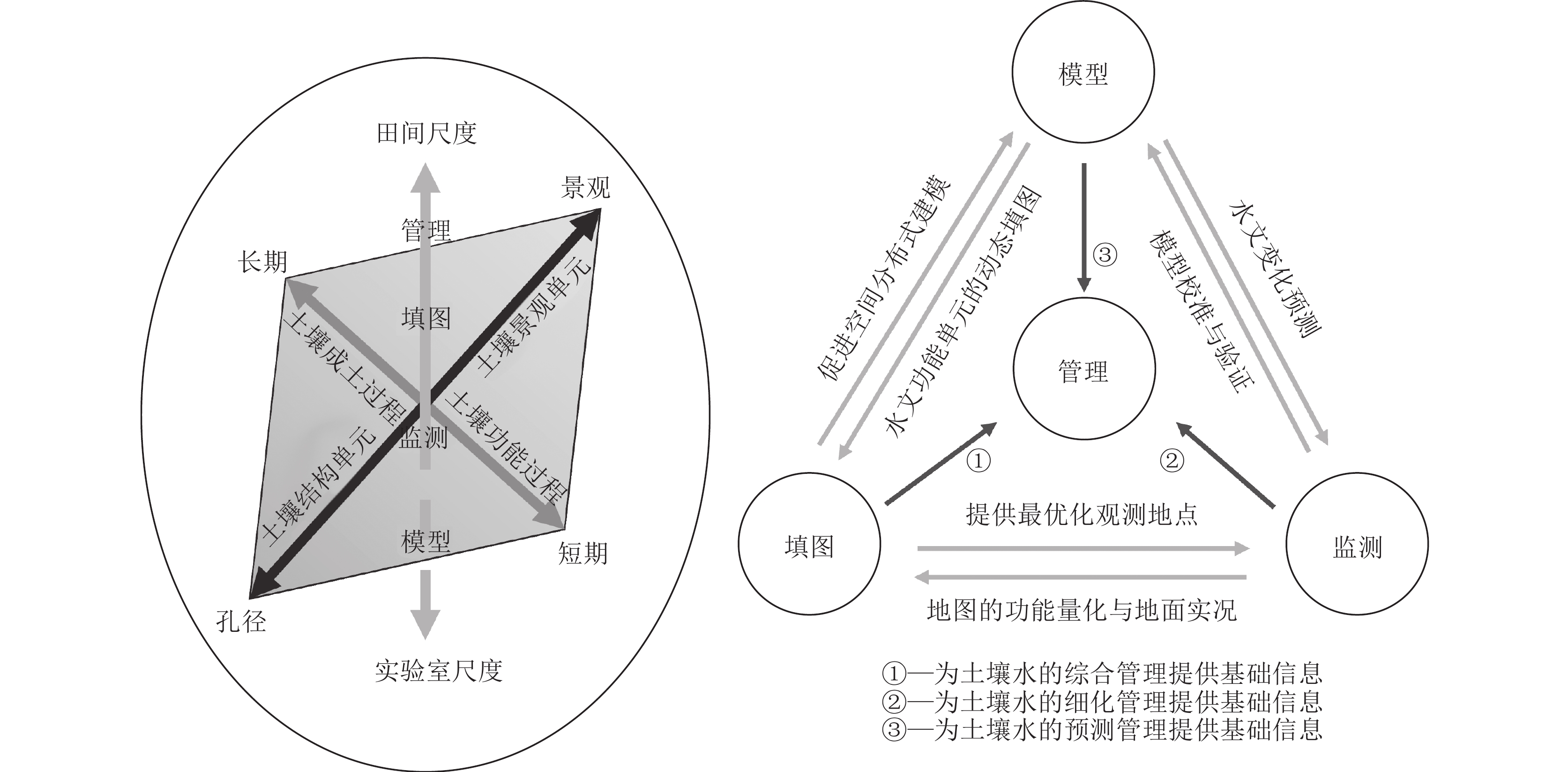
图 5 地球关键带土壤水文过程研究的时间、空间、方法三维框架和系统关系示意图(底图据Ma et al., 2017)
Figure 5.
表 1 土壤水分监测方法及特点
Table 1. Typical methods and characteristics of soil moisture monitoring
监测方法 应用尺度 探测方式 相关设备及技术 适用性 局限性 取样称重烘干法 田间、场地尺度 直接 烘箱、烘干法水分
测定仪等操作方便,设备简单,精度高 连续取样工作量大,费时费力 中子散射法(Fan et al., 2010; 魏玉涛等,2021) 田间、场地尺度 直接 中子水分测定仪 可周期性测定土壤水分,获取
实时数据,精度高垂直分辨率较差,因存在放射源
导致安全性较差土壤水势法(常学尚等,2021; Li et al., 2022) 田间、场地尺度 间接 张力计、露点水势仪等 操作方便,仪器设备简单 易受环境影响,测量精度低 介电常数法(Noborio, 2001) 坡面、田间、场地尺度 间接 时域反射仪(TDR)、
频域反射仪(FDR)布设及操作方便,对土体扰动
小,响应快,精度高易受到土壤孔隙、温度及容重影响 示踪剂法(Ren et al., 2018) 流域、坡面、田间尺度 间接 同位素示踪剂、
温度示踪剂等投放简单,不存在放射性危害 某些示踪剂需要排除
降水对实验的影响地球物探技术反演法
(朱青等,2019)流域、坡面、田间尺度 间接 电阻率层析成像仪(ERT)、探地雷达(GPR)、大地电导率仪(EMI)、宇宙射线中子流(CRNP)等 探测灵敏度高,可实现高密度
数据采集,并快速反演高空
间分辨率的土壤水分仪器成本高,图像解译难度较大,数据反演
依赖于经验关系和物理模型遥感法(胡猛等,2013;
贺缠生等,2021)区域、流域尺度 间接 植被指数法、微波技术遥感法、高光谱遥感法 成本低,动态对比性强,
适用于大尺度监测作物生长和植被覆盖通常会对
土壤水反演精度造成影响模型模拟法(Narayanan et al., 2001; 申慧娟等,2003) 不限 间接 神经网络模型、陆面数据同化模型、土壤水动力学模型等 时间及人力成本投入低,
数据获取量高侧重于数学建模,强调理论探索,
相关研究尚需深入 下载: 导出CSV
表 2 地球关键带土壤水文模型及应用特征
Table 2. Soil moisture models and their application characteristics in Earth’s Critical Zone
模型名称 开发年份 开发国家 应用尺度 应用范围 模型功能 EPIC 模型(Williams
et al., 1984)1984 美国 田间尺度 土壤侵蚀连续模拟 综合评估土壤侵蚀对生产力的影响,并预测管理模式对土壤、水分、养分、农药运动及作物产量的影响 SPAW 模型
(Arora et al., 1996)1989 美国 流域、田间尺度 径流、渗透、蒸发蒸腾
和土壤水渗流模拟预测农业水文学及其与土壤和作物生产的相互作用 VIC模型(Liang et al., 1994) 1992 美国 区域、流域尺度 陆面过程、汇流模拟 基于空间分布网格化的分布式水文模型,可同时进行陆−气间能量平衡和水量平衡的模拟 WAVES 模型(Zhang et al., 1996; 叶林媛等,2020) 1993 澳大利亚 田间尺度 生态系统蒸渗及水盐平衡
模拟在日时间步长上模拟土壤−植物−大气连续体中水、能量、溶质的动态输移过程 SWAT模型
(Arnold et al., 1993)1994 美国 流域尺度 水土流失、非点源污染、
农业管理及径流模拟预测在大流域复杂土壤类型、土地利用方式下,土地管理对水分、泥沙和化学物质的长期影响 HYDRUS 模型
(廖凯华等,2018)1998 美国 坡面、田间尺度 土壤水分和溶质运移模拟 采用Richards方程(Celia et al.,1990)描述土壤水分运动过程,模拟饱和多孔介质的水流、溶质运移、根系吸水和溶质吸收、热量传输模拟
下载: 导出CSV
-
[1] Amundson R, Richter D D, Humphreys G S, et al. 2007. Coupling between biota and earth materials in the critical zone[J]. Elements (Quebec), 3(5): 327−332. doi: 10.2113/gselements.3.5.327
[2] Arnold J G, Allen P M, Bernhardt G. 1993. A comprehensive surface−groundwater flow model[J]. Journal of Hydrology, 142(1): 47−69.
[3] Arora V K, Gajri P R. 1996. Performance of simplified water balance models under maize in a semiarid subtropical environment[J]. Agricultural Water Management, 31(1): 51−64.
[4] Bai X, Jia X X, Zhao C L, et al. 2021. Artificial forest conversion into grassland alleviates deep−soil desiccation in typical grass zone on China's loess plateau: Regional modeling[J]. Agriculture Ecosystems & Environment, 320: 107608.
[5] Blöschl G, Cudennec C, Fiori A, et al. 2019. Twenty−three unsolved problems in hydrology (uph)−A community perspective[J]. Hydrological Sciences Journal, 64(10): 1141−1158. doi: 10.1080/02626667.2019.1620507
[6] Bouma J. 2012. Chapter 15−hydropedology as a powerful tool for environmental policy and regulations: Toward sustainable land use, management and planning[C]//Lin H. Hydropedology. Boston: Academic Press: 483−512.
[7] Castellini M, Di Prima S, Stewart R, et al. 2022. Advances in ecohydrology for water resources optimization in arid and semi−arid areas[J]. Water, 14(12): 1830. doi: 10.3390/w14121830
[8] Celia M A, Bouloutas E T, Zarba R L. 1990. A general mass−conservative numerical solution for the unsaturated flow equation[J]. Water Resources Research, 26(7): 1483−1496. doi: 10.1029/WR026i007p01483
[9] Chang X S, Chang G Q. 2021. Advances in research and prospect on soil moisture in arid and semi−arid areas[J]. Journal of Desert Research, 41(1): 156−163(in Chinese with English abstract).
[10] Chen H, Shao M, Li Y. 2008. Soil desiccation in the loess plateau of China[J]. Geoderma, 143(1/2): 91−100. doi: 10.1016/j.geoderma.2007.10.013
[11] Chorover J, Kretzschmar R, Garcia−Pichel F, et al. 2007. Soil biogeochemical processes within the critical zone[J]. Elements, 3(5): 321−326.
[12] Cleverly J, Eamus D, Restrepo Coupe N, et al. 2016. Soil moisture controls on phenology and productivity in a semi−arid critical zone[J]. Science of the Total Environment, 568: 1227−1237. doi: 10.1016/j.scitotenv.2016.05.142
[13] Dexter A R. 1988. Advances in characterization of soil structure[J]. Soil & Tillage Research, 11(3/4): 199−238.
[14] Dexter A R, Young I M. 1992. Soil physics towards 2000[J]. Soil & Tillage Research, 24(2): 101−106.
[15] Ding W B, Wang F. 2022. The effects of vegetation construction on soil moisture in the loess plateau of China[J]. Acta Ecologica Sinica, 42(13): 5531−5542(in Chinese with English abstract).
[16] Fan J, Shao M A, Wang Q J, et al. 2010. Toward sustainable soil and water resources use in China's highly erodible semi−arid loess plateau[J]. Geoderma, 155(1/2): 93−100. doi: 10.1016/j.geoderma.2009.11.027
[17] Feng H M , Lei T W, Zhang J W, et al. 2009. An introduction of soil and water conservation legal system in USA[J]. Research of Soil and Water Conservation, 16(3): 276−280(in Chinese with English abstract).
[18] Feng X, Fu B, Piao S, et al. 2016. Revegetation in China's loess plateau is approaching sustainable water resource limits[J]. Nature Climate Change, 6(11): 1019. doi: 10.1038/nclimate3092
[19] Georgiou K, Jackson R B, Vinduskova O, et al. 2022. Global stocks and capacity of mineral−associated soil organic carbon[J]. Nature Communications, 13(1): 1−12.
[20] Grunwald S. 2009. Multi−criteria characterization of recent digital soil mapping and modeling approaches[J]. Geoderma, 152(3): 195−207.
[21] Grunwald S, Thompson J A, Boettinger J L. 2011. Digital soil mapping and modeling at continental scales: Finding solutions for global issues[J]. Soil Science Society of America Journal, 75(4): 1201−1213. doi: 10.2136/sssaj2011.0025
[22] Guan Y, Zhou W, Bai Z, et al. 2020. Soil nutrient variations among different land use types after reclamation in the Pingshuo opencast coal mine on the loess plateau, China[J]. Catena, 188: 104427. doi: 10.1016/j.catena.2019.104427
[23] Gutiérrez Jurado H A, Vivoni E R, Harrison J B J, et al. 2006. Ecohydrology of root zone water fluxes and soil development in complex semiarid rangelands[J]. Hydrological Processes, 20(15): 3289−3316. doi: 10.1002/hyp.6333
[24] Hartemink A E, Minasny B. 2016. Digital soil morphometrics[M]. Springer International Publishing.
[25] He C S, Tian J, Zhang B Q, et al. 2021. A review of advances in impacts of soil hydraulic properties on hydrological processes, challenges and opportunities[J]. Advances in Earth Science, 36(2): 113−124(in Chinese with English abstract).
[26] He H S, Mladenoff D J, Crow T R. 1999. Linking an ecosystem model and a landscape model to study forest species response to climate warming[J]. Ecological Modelling, 114(2/3): 213−233. doi: 10.1016/S0304-3800(98)00147-1
[27] Hengl T, de Jesus J M, Heuvelink G B M, et al. 2017. Soilgrids250m: global gridded soil information based on machine learning[J]. Plos One, 12(2): 1−40.
[28] Huang L M, Shao M A. 2019. Advances and perspectives on soil water research in China's loess plateau[J]. Earth−Science Reviews, 199: 102962.
[29] Huang M, Gallichand J. 2006. Use of the shaw model to assess soil water recovery after apple trees in the gully region of the loess plateau, China[J]. Agricultural Water Management, 85(1/2): 67−76. doi: 10.1016/j.agwat.2006.03.009
[30] Huang T M, Pang Z H. 2011. Estimating groundwater recharge following land−use change using chloride mass balance of soil profiles: A case study at Guyuan and Xifeng in the loess plateau of China[J]. Hydrogeology Journal, 19(1): 177−186. doi: 10.1007/s10040-010-0643-8
[31] Huang T, Pang Z, Edmunds W M. 2013. Soil profile evolution following land−use change: implications for groundwater quantity and quality[J]. Hydrological Processes, 27(8): 1238−1252. doi: 10.1002/hyp.9302
[32] Hu M, Feng Q, Xi H Y. 2013. Progress of monitoring soil moisture by remote sensing in arid areas[J]. Chinese Journal of Soil Science, 44(5): 1270−1275(in Chinese with English abstract).
[33] Jiao F, Wen Z M, Chen Y M. 2005. Mapping and quantitative analysis of soil moisture using GIS techniques[J]. Research of Soil and Water Conservation, 12(3): 129−131,177(in Chinese with English abstract).
[34] Jiao F, Wen Z M, Chen Y M, et al. 2006. Mapping and quantitative analysis of soil moisture of Ansai county based on GIS techniques[J]. Science of Soil and Water Conservation, 4(1): 75−80(in Chinese with English abstract).
[35] Jia X, Shao M A, Wei X, et al. 2020. Policy development for sustainable soil water use on China's loess plateau[J]. Science Bulletin, 65(24): 2053−2056. doi: 10.1016/j.scib.2020.09.006
[36] Jin Q, Zhang J, Shi M, et al. 2016. Estimating loess plateau average annual precipitation with multiple linear regression kriging and geographically weighted regression kriging[J]. Water, 8(6): 266. doi: 10.3390/w8060266
[37] Li B, Wang Y, Hill R L, et al. 2019. Effects of apple orchards converted from farmlands on soil water balance in the deep loess deposits based on HYDRUS−1D model[J]. Agriculture, Ecosystems & Environment, 285: 106645.
[38] Li H, Han S, Wu X, et al. 2021. Distribution, characteristics and influencing factors of fresh groundwater resources in the loess plateau, China[J]. China Geology, 4(3): 509−526.
[39] Li H, Liu W, Zhan H, et al. 2022. Effect of barometric pumping on relative humidity in the loessal soil of the loess plateau[J]. Geoderma, 424: 116008.
[40] Li H, Si B, Li M. 2018. Rooting depth controls potential groundwater recharge on hillslopes[J]. Journal of Hydrology, 564: 164−174. doi: 10.1016/j.jhydrol.2018.07.002
[41] Li W, Wang Q J, Wei S P, et al. 2008. Soil desiccation for loess soils on natural and regrown areas[J]. Forest Ecology and Management, 255(7): 2467−2477. doi: 10.1016/j.foreco.2008.01.006
[42] Liang X, Lettenmaier D P, Wood E F, et al. 1994. A simple hydrologically based model of land surface water and energy fluxes for general circulation models[J]. Journal of Geophysical Research, 99(D7): 14415. doi: 10.1029/94JD00483
[43] Liao K H, Lu L G. 2018. Advances in research of hillslope soil hydrological processes in the humid region of Southeast China[J]. Progress in Geography, 37(4): 476−484(in Chinese with English abstract). doi: 10.18306/dlkxjz.2018.04.003
[44] Lin H. 2010. Earth's critical zone and hydropedology, concepts, characteristics, and advances[J]. Hydrology and Earth System Sciences, 14(1): 25−45. doi: 10.5194/hess-14-25-2010
[45] Lin H, Drohan P, Green T R. 2015. Hydropedology: the last decade and the next decade[J]. Soil Science Society of America Journal, 79(2): 357−361. doi: 10.2136/sssaj2015.02.0069
[46] Liu G B, Shang G Z P, Yao W Y, et al. 2017. Ecological effects of soil conservation in loess plateau[J]. Bulletin of Chinese Academy of Sciences, (1): 11−19(in Chinese with English abstract).
[47] Liu J, Rühland K M, Chen J, et al. 2017. Aerosol−weakened summer monsoons decrease lake fertilization on the Chinese loess plateau[J]. Nature Climate Change, 7(3): 190−194. doi: 10.1038/nclimate3220
[48] Li Z S, Yang L, Wang G L, et al. 2019. The management of soil and water conservation in the loess plateau of China: Present situations, problems, and counter−solutions[J]. Acta Ecologica Sinica, 39(20): 7398−7409(in Chinese with English abstract).
[49] Lu A G, Suo A N, Zhang L. 2011. Simulation of spatial pattern of soil water loss in a watershed of the loess plateau based SWAT model[J]. Research of Soil and Water Conservation, 18(2): 57−61(in Chinese with English abstract).
[50] Luo Z B, Fan J, Shao M A. 2022. Progresses of weathered bedrock ecohydrology in the Earth's critical zone[J]. Chinese Science Bulletin, 67(27): 3311−3323(in Chinese with English abstract). doi: 10.1360/TB-2022-0046
[51] Lü Y, Hu J, Fu B, et al. 2019. A framework for the regional critical zone classification: the case of the chinese loess plateau[J]. National Science Review, 6(1): 14−18. doi: 10.1093/nsr/nwy147
[52] Ma Y, Li X, Guo L, et al. 2017. Hydropedology: interactions between pedologic and hydrologic processes across spatiotemporal scales[J]. Earth−Science Reviews, 171: 181−195. doi: 10.1016/j.earscirev.2017.05.014
[53] Mccoll K A, Alemohammad S H, Akbar R, et al. 2017. The global distribution and dynamics of surface soil moisture[J]. Nature Geoscience, 10(2): 100. doi: 10.1038/ngeo2868
[54] Mcmillan H, Gueguen M, Grimon E, et al. 2014. Spatial variability of hydrological processes and model structure diagnostics in a 50 km2 catchment[J]. Hydrological Processes, 28(18): 4896−4913. doi: 10.1002/hyp.9988
[55] Mello C R D, Norton L D, Pinto L C, et al. 2016. Agricultural watershed modeling: a review for hydrology and soil erosion processes[J]. Ciência E Agrotecnologia, 40(1): 7−25.
[56] Narayanan R M, Hirsave P P. 2001. Soil moisture estimation models using sir−c sar data: a case study in new hampshire, USA[J]. Remote Sensing of Environment, 75(3): 385−396. doi: 10.1016/S0034-4257(00)00181-4
[57] Noborio K. 2001. Measurement of soil water content and electrical conductivity by time domain reflectometry: A review[J]. Computers and Electronics in Agriculture, 31(3): 213−237. doi: 10.1016/S0168-1699(00)00184-8
[58] Peng X H, Wang Y Q, Jia X X, et al. 2020. Some key research fields of Chinese soil physics in the new era: Progresses and perspectives[J]. Acta Pedologica Sinica, 57(5): 1071−1087(in Chinese with English abstract).
[59] Qiao X T, Cao Y, Bi R T. 2019. Characteristics of soil water content of reclamation farmland in mining area of the loess plateau based on AEA method[J]. Chinese Journal of Soil Science, 50(1): 63−69(in Chinese with English abstract).
[60] Quinlan J R. 1996. Improved use of continuous attributes in C4.5[J]. Journal of Artificial Intelligence Research, 4: 77−90. doi: 10.1613/jair.279
[61] Rao P, Wang Y, Liu Y, et al. 2022. A comparison of multiple methods for mapping groundwater levels in the MU US sandy land, China[J]. Journal of Hydrology: Regional Studies, 43: 101189. doi: 10.1016/j.ejrh.2022.101189
[62] Ren J, Wang X, Shen Z, et al. 2018. Heat tracer test in a riparian zone: laboratory experiments and numerical modelling[J]. Journal of Hydrology, 563: 560−575. doi: 10.1016/j.jhydrol.2018.06.030
[63] Richardson M, Kumar P. 2017. Critical zone services as environmental assessment criteria in intensively managed landscapes[J]. Earth's Future, 5(6): 617−632. doi: 10.1002/2016EF000517
[64] Richter D D, Mobley M L. 2009. Monitoring earth's critical zone[J]. Science, 326(5956): 1067−1068. doi: 10.1126/science.1179117
[65] Sayde C, Buelga J B, Rodriguez−Sinobas L, et al. 2014. Mapping variability of soil water content and flux across 1−1000 m scales using the actively heated fiber optic method[J]. Water Resources Research, 50(9): 7302−7317. doi: 10.1002/2013WR014983
[66] Sciences C O B R. 2001. Basic research opportunities in earth science[M]: National Academy Press.
[67] Shao M, Wang Y, Xia Y, et al. 2018. Soil drought and water carrying capacity for vegetation in the critical zone of the loess plateau: A review[J]. Vadose Zone Journal, 17(1): 1−8.
[68] Shao X M, Yan C R, Xu Z J. 2004. Progress in monitoring and simulation of soil moisture[J]. Progress in Geography, 23(3): 58−66(in Chinese with English abstract).
[69] Shen H J, Yan C R, Dai Y P. 2003. Progress and application of soil moisture monitoring and forecasting models[J]. Ecologic Science, 22(4): 366−370,376(in Chinese with English abstract).
[70] Sun A, Guo Z, Wu H, et al. 2017. Reconstruction of the vegetation distribution of different topographic units of the Chinese loess plateau during the Holocene[J]. Quaternary Science Reviews, 173: 236−247. doi: 10.1016/j.quascirev.2017.08.006
[71] Sun H, Wang Y, Zhao Y, et al. 2020. Assessing the value of electrical resistivity derived soil water content: Insights from a case study in the critical zone of the Chinese loess plateau[J]. Journal of Hydrology, 589: 125132. doi: 10.1016/j.jhydrol.2020.125132
[72] Sun P P, Zhang M S, Jiang R J, et al. 2021. Deformation and failure mechanism of rainfall−induced shallow loess landside[J]. Geological Bulletin of China, 40(10): 1617−1625.
[73] Sun Y S, Chou R R, Deng X. 2014. Research development of mapping knowledge domains in China——Analysis based on CiteSpace Ⅱ[J]. Journal of Modern Information, 34(1): 84−88(in Chinese with English abstract).
[74] Tang Q, Xu Y, Bennett S J, et al. 2015. Assessment of soil erosion using rusle and gis: a case study of the yangou watershed in the loess plateau, China[J]. Environmental Earth Sciences, 73(4): 1715−1724. doi: 10.1007/s12665-014-3523-z
[75] Vose J M, Sun G, Ford C R, et al. 2011. Forest ecohydrological research in the 21st century: what are the critical needs?[J]. Ecohydrology, 4(2): 146−158. doi: 10.1002/eco.193
[76] Wang H, Zhao W W, Jia L Z. 2021. Progress and prospect of soil water erosion research over past decade based on the bibliometrics analysis[J]. Science of Soil and Water Conservation, 19(1): 141−151(in Chinese with English abstract).
[77] Wang J, Zhao W, Jia L, et al. 2021. Soil desiccation trends after afforestation in the loess plateau of China[J]. Journal of Soils and Sediments, 21(2): 1165−1176. doi: 10.1007/s11368-020-02845-3
[78] Wang Q, Fan J, Wang S, et al. 2019. Application and accuracy of cosmic−ray neutron probes in three soil textures on the loess plateau, China[J]. Journal of Hydrology, 569: 449−461. doi: 10.1016/j.jhydrol.2018.11.073
[79] Wang X C, Li J, Tahir M N, et al. 2011. Validation of the epic model using a long−term experimental data on the semi−arid loess plateau of China[J]. Mathematical and Computer Modelling, 54(3/4): 976−986. doi: 10.1016/j.mcm.2010.11.025
[80] Wang X, Hu G, Saito Y, et al. 2022. Did the modern yellow river form at the mid−pleistocene transition ?[J]. Science Bulletin, 67(15): 1603−1610. doi: 10.1016/j.scib.2022.06.003
[81] Wang Y Q, Hu W, Sun H, et al. 2024. Soil moisture decline in China's monsoon loess critical zone: More a result of land−use conversion than climate change[J]. Proceedings of the National Academy of Sciences, 121(15): e2322127121.
[82] Wang Y Q, Shao M A, Hu W, et al. 2016. Spatial variations of soil water content in the critical zone of the Chinese loess plateau[J]. Earth and Environment, 44(4): 391−397(in Chinese with English abstract).
[83] Wang Y Q, Shao M A, Sun H, et al. 2020. Response of deep soil drought to precipitation, land use and topography across a semiarid watershed[J]. Agricultural and Forest Meteorology, 282: 107866.
[84] Wang Y S, Xia S T. 2018. A survey of random forests algorithms[J]. Information and Communications Technologies, 12(1): 49−55(in Chinese with English abstract).
[85] Wei Y T, Liu M H, Liu K, et al. 2021. Progress of multi−scale soil moisture monitoring[J]. Chinese Agricultural Science Bulletin, 37(26): 140−145(in Chinese with English abstract).
[86] Williams J R, Jones C A, Dyke P T. 1984. A modeling approach to determining the relationship between erosion and soil productivity.[J]. Transactions of the Asae, 27(1): 129−144. doi: 10.13031/2013.32748
[87] Wu P T, Zhao X N, Zhang B Q, et al. 2017. Exploitation of rainwater harvesting potential and its impact on regional ecological restoration over the loess plateau[J]. Journal of Hydroelectric Engineering, 36(8): 1−11(in Chinese with English abstract).
[88] Xiao B, Wang Q H, Zhao Y G, et al. 2011. Artificial culture of biological soil crusts and its effects on overland flow and infiltration under simulated rainfall[J]. Applied Soil Ecology, 48(1): 11−17. doi: 10.1016/j.apsoil.2011.02.006
[89] Yang Q, Luo W, Jiang Z, et al. 2016. Improve the prediction of soil bulk density by cokriging with predicted soil water content as auxiliary variable[J]. Journal of Soils and Sediments, 16(1): 77−84. doi: 10.1007/s11368-015-1193-4
[90] Ye L Y, Liu P, Huang J X, et al. 2020. Estimation of water consumption characteristics of typical ecosystems in the Daqing River Basin using WAVES model[J]. China Rural Water and Hydropower, (8): 35−39(in Chinese with English abstract).
[91] Zhang C, Tang Y, Xu X, et al. 2011. Towards spatial geochemical modelling: use of geographically weighted regression for mapping soil organic carbon contents in Ireland[J]. Applied Geochemistry, 26(7): 1239−1248. doi: 10.1016/j.apgeochem.2011.04.014
[92] Zhang C, Wang Y, Jia X, et al. 2020. Variations in capacity and storage of plant−available water in deep profiles along a revegetation and precipitation gradient[J]. Journal of Hydrology, 581: 124401. doi: 10.1016/j.jhydrol.2019.124401
[93] Zhang G L, Shi Z, Zhu A X, et al. 2020. Progress and perspective of studies on soils in space and time[J]. Acta Pedologica Sinica, 57(5): 1060−1070(in Chinese with English abstract).
[94] Zhang L, Dawes W R, Hatton T J. 1996. Modelling hydrologic processes using a biophysically based model−application of waves to fife and hapex−mobilhy[J]. Journal of Hydrology, 185(1/4): 147−169. doi: 10.1016/0022-1694(95)03006-9
[95] Zhang Y T, Xiao H B, Nie X D, et al. 2020. Evolution of research on soil Erosion at home and abroad in the past 30 years—Based on bibliometric analysis[J]. Acta Pedologica Sinica, 57(4): 797−810(in Chinese with English abstract).
[96] Zhen Q, Zheng J, Zhang X, et al. 2019. Changes of solute transport characteristics in soil profile after mining at an opencast coal mine site on the loess plateau, China[J]. Science of the Total Environment, 665: 142−152. doi: 10.1016/j.scitotenv.2019.02.035
[97] Zhu A N, Ji L Q, Zhang J B, et al. 2009. Research progress on soil moisture measurement via ground−penetrating radar[J]. Chinese Journal of Eco−Agriculture, 17(5): 1039−1044(in Chinese with English abstract). doi: 10.3724/SP.J.1011.2009.01039
[98] Zhu A X, Band L, Vertessy R, et al. 1997. Derivation of soil properties using a soil land inference model (solim)[J]. Soil Science Society of America Journal, 61(2): 523−533. doi: 10.2136/sssaj1997.03615995006100020022x
[99] Zhu Q, Liao K H, Lai X M, et al. 2019. A review of soil water monitoring and modelling across spatial scales in the watershed[J]. Progress in Geography, 38(8): 1150−1158(in Chinese with English abstract). doi: 10.18306/dlkxjz.2019.08.004
[100] Zou C B, Turton D J, Will R E, et al. 2014. Alteration of hydrological processes and streamflow with Juniper (Juniperus Jirginiana) encroachment in a mesic grassland catchment[J]. Hydrological Processes, 28(26): 6173−6182. doi: 10.1002/hyp.10102
[101] Zou J L, Shao M, Gong S H. 2011. Effects of different vegetation and soil types on profile variability of soil moisture[J]. Research of Soil and Water Conservation, 18(6): 12−17(in Chinese with English abstract).
[102] 常学尚, 常国乔. 2021. 干旱半干旱区土壤水分研究进展[J]. 中国沙漠, 41(1): 156−163.
[103] 丁文斌, 王飞. 2022. 植被建设对黄土高原土壤水分的影响[J]. 生态学报, 42(13): 5531−5542.
[104] 冯慧敏, 雷廷武, 张久文, 等. 2009. 美国水土保持法律法规简介[J]. 水土保持研究, 16(3): 276−280.
[105] 贺缠生, 田杰, 张宝庆, 等. 2021. 土壤水文属性及其对水文过程影响研究的进展、挑战与机遇[J]. 地球科学进展, 36(2): 113−124. doi: 10.11867/j.issn.1001-8166.2021.016
[106] 胡猛, 冯起, 席海洋. 2013. 遥感技术监测干旱区土壤水分研究进展[J]. 土壤通报, 44(5): 1270−1275.
[107] 焦峰, 温仲明, 陈云明. 2005. 基于GIS的黄丘区土壤水分制图及其定量化分析[J]. 水土保持研究, 12(3): 129−131,177. doi: 10.3969/j.issn.1005-3409.2005.03.042
[108] 焦峰, 温仲明, 陈云明, 等. 2006. 基于gis的安塞县土壤水分制图及其数量分析[J]. 中国水土保持科学, 4(1): 75−80. doi: 10.3969/j.issn.1672-3007.2006.01.014
[109] 李宗善, 杨磊, 王国梁, 等. 2019. 黄土高原水土流失治理现状、问题及对策[J]. 生态学报, 39(20): 7398−7409.
[110] 廖凯华, 吕立刚. 2018. 东南湿润区坡面土壤水文过程研究进展与展望[J]. 地理科学进展, 37(4): 476−484.
[111] 刘国彬, 上官周平, 姚文艺, 等. 2017. 黄土高原生态工程的生态成效[J]. 中国科学院院刊, (1): 11−19.
[112] 卢爱刚, 索安宁, 张镭. 2011. 基于SWAT模型的黄土高原典型区水土流失格局模拟评价[J]. 水土保持研究, 18(2): 57−61.
[113] 骆占斌, 樊军, 邵明安. 2022. 地球关键带基岩风化层生态水文研究进展[J]. 科学通报, 67(27): 3311−3323.
[114] 彭新华, 王云强, 贾小旭, 等. 2020. 新时代中国土壤物理学主要领域进展与展望[J]. 土壤学报, 57(5): 1071−1087. doi: 10.11766/trxb202002280077
[115] 乔新涛, 曹毅, 毕如田. 2019. 基于AEA法的黄土高原矿区复垦农田土壤含水率特征研究[J]. 土壤通报, 50(1): 63−69.
[116] 邵晓梅, 严昌荣, 徐振剑. 2004. 土壤水分监测与模拟研究进展[J]. 地理科学进展, 23(3): 58−66. doi: 10.3969/j.issn.1007-6301.2004.03.008
[117] 申慧娟, 严昌荣, 戴亚平. 2003. 农田土壤水分预测模型的研究进展及应用[J]. 生态科学, 22(4): 366−370,376. doi: 10.3969/j.issn.1008-8873.2003.04.017
[118] 孙萍萍, 张茂省, 江睿君, 等. 2021. 降雨诱发浅层黄土滑坡变形破坏机制[J]. 地质通报, 40(10): 1617−1625. doi: 10.12097/j.issn.1671-2552.2021.10.003
[119] 孙雨生, 仇蓉蓉, 邓兴. 2014. 国内知识图谱研究进展——基于citespace ⅱ的分析[J]. 现代情报, 34(1): 84−88. doi: 10.3969/j.issn.1008-0821.2014.01.019
[120] 王涵, 赵文武, 贾立志. 2021. 近10年土壤水蚀研究进展与展望: 基于文献计量的统计分析[J]. 中国水土保持科学(中英文), 19(1): 141−151.
[121] 王奕森, 夏树涛. 2018. 集成学习之随机森林算法综述[J]. 信息通信技术, 12(1): 49−55. doi: 10.3969/j.issn.1674-1285.2018.01.009
[122] 王云强, 邵明安, 胡伟, 等. 2016. 黄土高原关键带土壤水分空间分异特征[J]. 地球与环境, 44(4): 391−397.
[123] 魏玉涛, 刘明欢, 刘可, 等. 2021. 多尺度土壤水监测研究进展[J]. 中国农学通报, 37(26): 140−145. doi: 10.11924/j.issn.1000-6850.casb2021-0145
[124] 吴普特, 赵西宁, 张宝庆, 等. 2017. 黄土高原雨水资源化潜力及其对生态恢复的支撑作用[J]. 水力发电学报, 36(8): 1−11. doi: 10.11660/slfdxb.20170801
[125] 叶林媛, 刘攀, 黄俊雄, 等. 2020. 基于WAVES模型的大清河流域典型生态系统耗水特征分析[J]. 中国农村水利水电, (8): 35−39. doi: 10.3969/j.issn.1007-2284.2020.08.007
[126] 张甘霖, 史舟, 朱阿兴, 等. 2020. 土壤时空变化研究的进展与未来[J]. 土壤学报, 57(5): 1060−1070. doi: 10.11766/trxb202004270199
[127] 张宇婷, 肖海兵, 聂小东, 等. 2020. 基于文献计量分析的近30年国内外土壤侵蚀研究进展[J]. 土壤学报, 57(4): 797−810. doi: 10.11766/trxb201906030237
[128] 朱安宁, 吉丽青, 张佳宝, 等. 2009. 基于探地雷达的土壤水分测定方法研究进展[J]. 中国生态农业学报, 17(5): 1039−1044.
[129] 朱青, 廖凯华, 赖晓明, 等. 2019. 流域多尺度土壤水分监测与模拟研究进展[J]. 地理科学进展, 38(8): 1150−1158. doi: 10.18306/dlkxjz.2019.08.004
[130] 邹俊亮, 邵明安, 龚时慧. 2011. 不同植被和土壤类型下土壤水分剖面的分异[J]. 水土保持研究, 18(6): 12−17.
-


图(6)
表(2)
计量
- 文章访问数: 1672
- PDF下载数: 249
- 施引文献: 0