

-
摘要:
研究目的 喜马拉雅山地区大型—巨型古滑坡发育,近年来古滑坡复活问题日益突出,潜在危害严重。然而,内外动力耦合作用下的古滑坡复活机理不清,导致危险性预测不准。
研究方法 以西藏山南市隆子县加玉乡庞村古滑坡为研究对象,采用遥感解译、现场调查、工程地质钻探、综合监测等方法,分析了庞村古滑坡发育特征与复活影响因素,并采用数值模拟技术预测滑坡失稳后的运动过程,评价其潜在危险性。
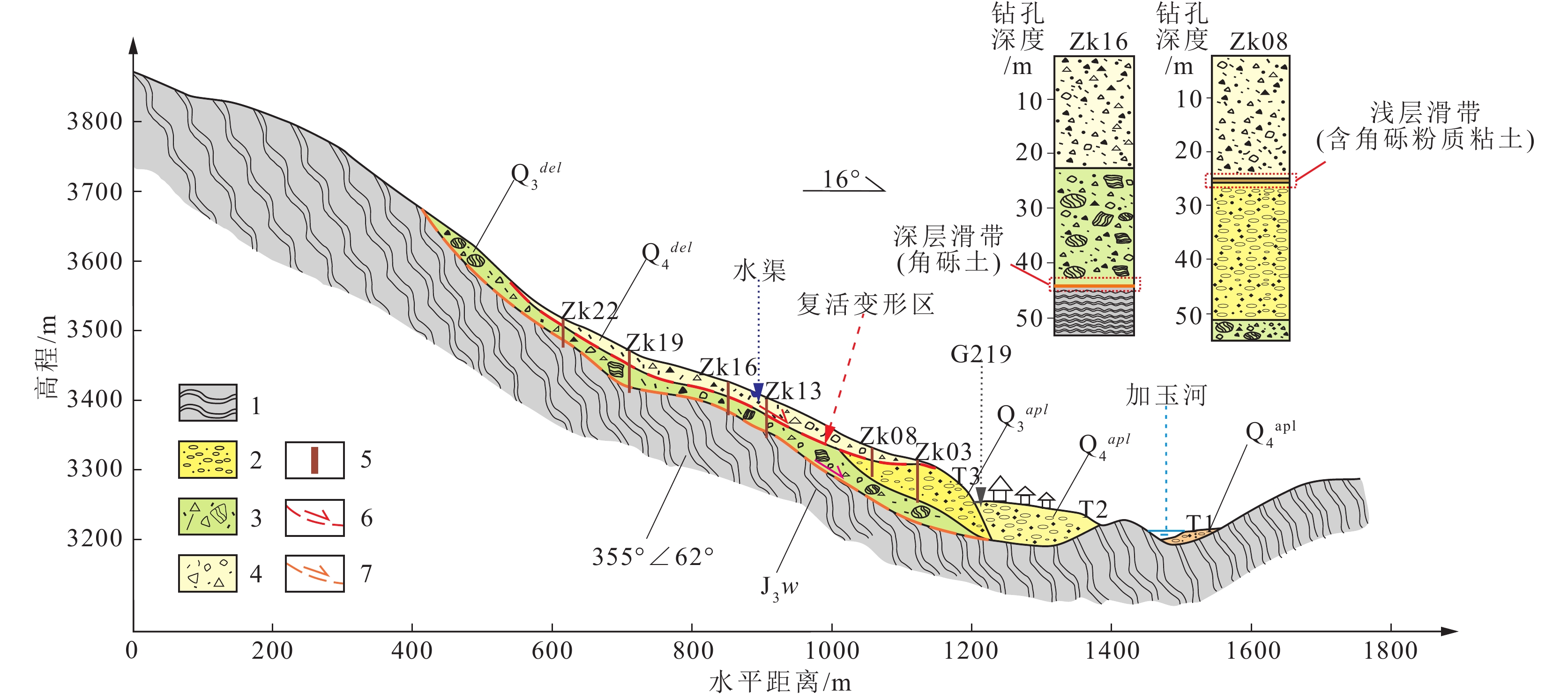
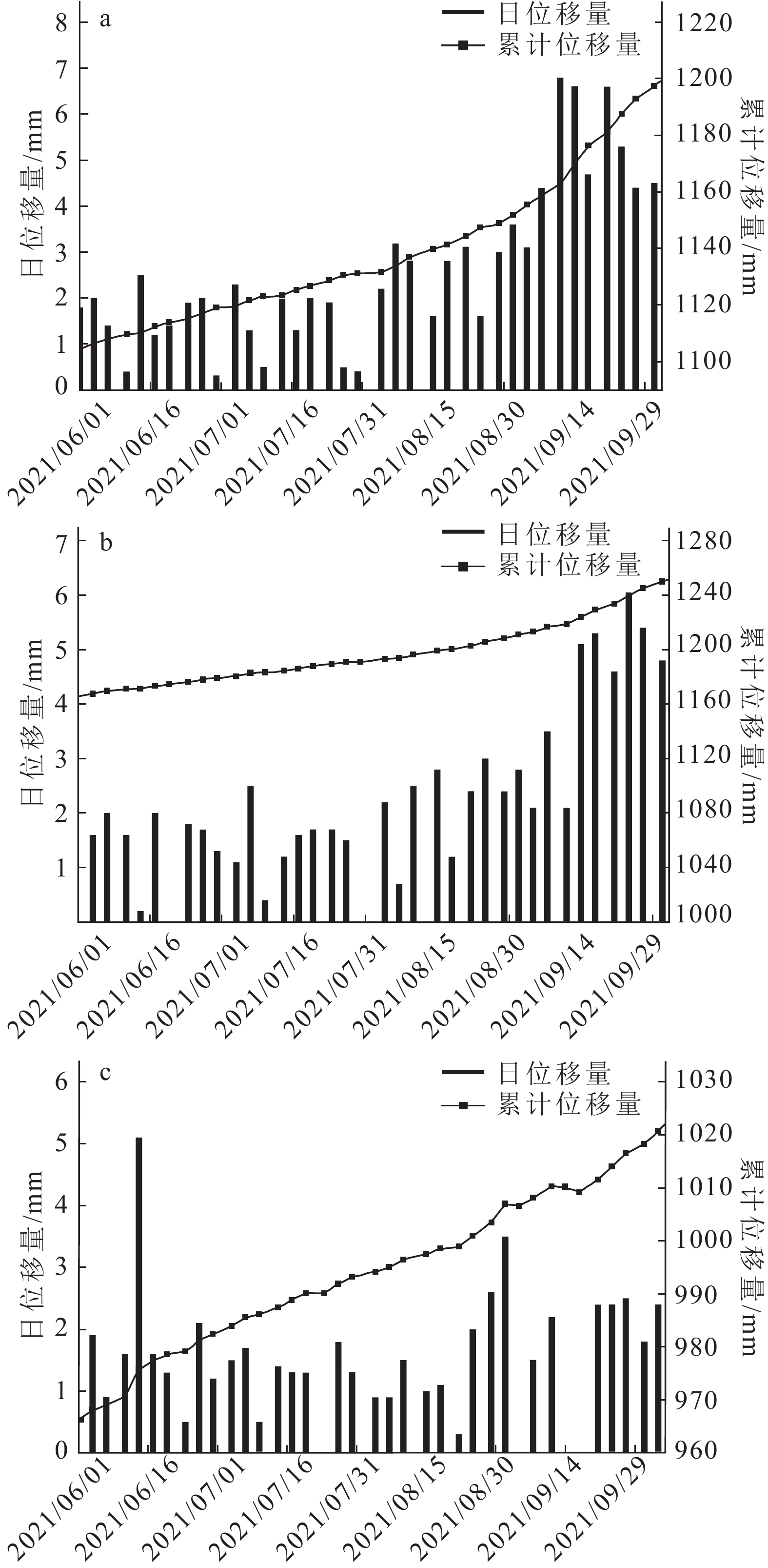
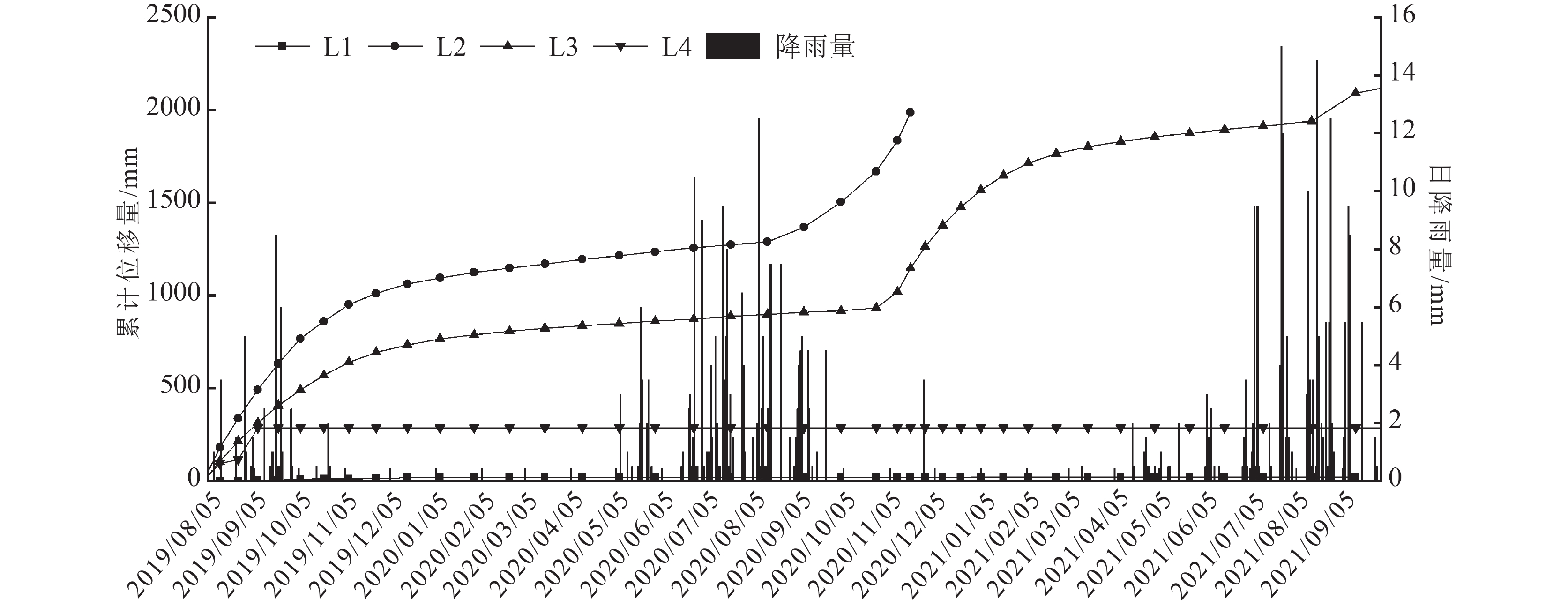
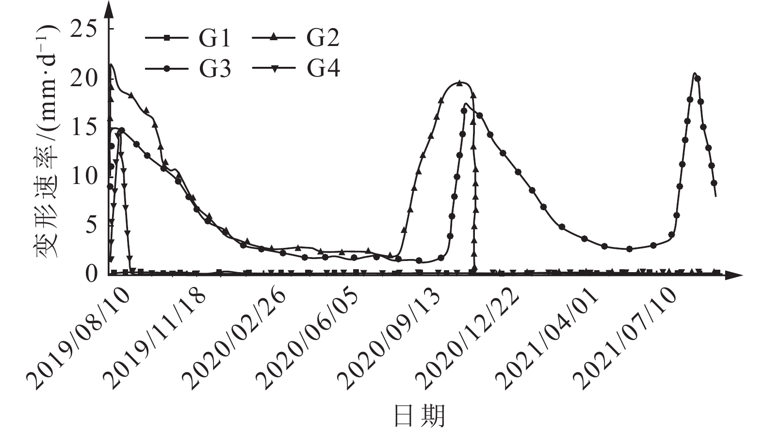
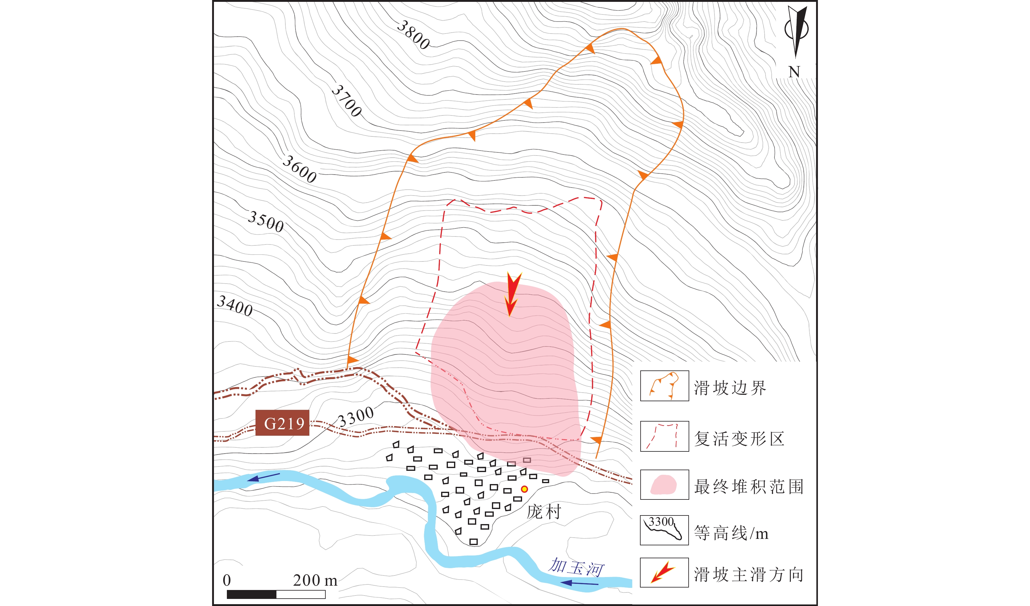
研究结果 庞村滑坡最早发生于中—晚更新世,体积约18.9×10⁶ m3,滑坡发育两层滑带,埋深分别为6~25 m和25~55 m。目前滑坡复活变形特征明显,历史滑动所形成的碎石土堆积体是现今主要的复活变形区,该区左侧变形强烈,右侧变形较弱,其复活变形受降雨作用影响明显,周边地震活动也起到一定的促进作用。
结论 一旦滑坡复活变形区发生整体失稳,滑体最大堆积厚度达25 m,最大运动速度达16.52 m/s,最远距离达175 m,将严重威胁坡脚的庞村居民区和国道G219。该研究结果对深化喜马拉雅山地区古滑坡复活机理的认识和支撑当地防灾减灾工作具有一定意义。
Abstract:Objective Intense amount of large ancient landslides are developing in the Himalayan region. In recent years, the problem of ancient landslide reactivation has become more and more prominent, and the potential hazards are serious. However, the mechanisms controlling the reactivation of ancient landslides under endogenic−exogenic dynamic coupling remain poorly constrained, which hinders accurate hazard predictions and risk mitigation strategies.
Methods Based on remote sensing interpretation, field investigation, engineering geological drilling and comprehensive monitoring, we analyze the development characteristics and reactivation factors of ancient landslide in Pangcun, Jiayu Township, Longzi County, Shannan City, Xizang. Numerical simulation is used to predict the movement process of landslide after instability and evaluate its potential risk.
Results The Pangcun landslide first slided in the middle to Late Pleistocene with a volume of about 18.9×10⁶ m3, and the landslide developed two layers of slip zones, with buried depths ranging from 6 m to 25 m and 25 m to 55 m, respectively. At present, the reactivation characteristics of the landslide are obvious, and the gravel soil accumulation formed by historical sliding is the reactivation and deformation area, which is strongly deformed on the left side and weakly deformed on the right side, and its deformation is obviously affected by rainfall, and the surrounding seismic activities also play a certain role in promoting its reactivation.
Conclusions Once the reactivation deformation area of the landslide occurs the whole instability, the maximum accumulation thickness of the slide body reaches 25 m, the maximum movement speed reaches 16.52 m/s, and the furthest distance reaches 175 m, which will seriously threaten the Pangcun residential area at the slope foot and the national highway G219. The study results have a certain significance for deepening the understanding of the ancient landslide reactivation mechanism in the Himalayan region and supporting the local disaster prevention and reduction work.
-

-
表 1 数值模拟参数取值
Table 1. Numerical simulation parameter values
岩土类型 土体密度ρ/
(kg·m−3)粘聚力φ/
kPa基底摩擦
系数μ孔隙水压
力系数B含角砾粉质粘土 2104 34.4 0.5 0.3  下载: 导出CSV
-
[1] Dai X J, Yin Y P, Xing A G. 2019. Simulation and dynamic analysis of Yigong rockslide−debris avalanche−dam breaking disaster chain[J]. The Chinese Journal of Geological Hazard and Control, 30(5): 1−8 (in Chinese with English abstract).
[2] Deng J H, Gao Y J, Yao X, et al. 2021. Recognition and implication of Basu giant rock avalanche[J]. Advanced Engineering Sciences, 53(3): 19−28 (in Chinese with English abstract).
[3] Delaney K B, Evans S G. 2015. The 2000 Yigong landslide (Tibetan Plateau), rockslide−dammed lake and outburst flood: review, remote sensing analysis, and process modelling[J]. Geomorphology, 246(1): 377−393.
[4] Du G L. 2017. Development characteristics and hazard assessment of landslide in the eastern Himalayan syntaxis region of Tibetan Plateau[D]. Doctoral Dissertation of Chinese Academy of Geological Sciences, Beijing (in Chinese with English abstract).
[5] Fan X M, Yang F, Siva S S, et al. 2020. Prediction of a multi−hazard chain by an integrated numerical simulation approach: the Baige landslide, Jinsha river, China[J]. Landslides, 17: 147−164.
[6] Horton A J, Hales T C, Ouyang C J, et al. 2019. Identifying post−earthquake debris flow hazard using Massflow[J]. Engineering Geology, 258: 105−134.
[7] Hu X H, Zhu D M, 2020. Stability analysis and control technique discussion of large landslide in Pang village, Jiayu township[J]. Engineering and Technological Research, 5(18): 116−118 (in Chinese with English abstract).
[8] Huang Y C. 2006. The neotectonics movement and its effecton environment and resources in Menba area, Tibet[D]. Master Dissertation of Jilin University (in Chinese with English abstract).
[9] Li J X, Wang C M, Wang G C. 2013. Landslide risk assessment based on combination weighting−unascertained measure theory[J]. Rock and Soil Mechanics, 34(2): 468−474 (in Chinese with English abstract).
[10] Li J X. 2011. Formation mechanism and non−linear prediction of landslide hazards in Longzi county, Tibet[D]. Doctoral Dissertation of Jilin University (in Chinese with English abstract).
[11] Liu C Z, Lu J T, Tong L Q, et al. 2019. Research on glacial/rock fall−landslide−debris flows in Sedongpu basin Alonoyarlung Zangbo river in Tibet[J]. Geology in China, 46(2): 219−234 (in Chinese with English abstract).
[12] Liu C L, Qi S W, Tong L Q, et al. 2010. Great landslides in Himalaya mountain area and their occurrence with lithology[J]. Journal of Engineering Geology, 18(5): 669−676 (in Chinese with English abstract).
[13] Ouyang C J, He S M, Xu Q, et al. 2013. A Maccormack− TVD finite difference method to simulate the mass flow in mountainous terrain with variable computational domain[J]. Computers & Geosciences, 52: 1−10.
[14] Ouyang C J, He S M, Xu, Q. 2015. Maccormack−TVD finite difference solution for dam break hydraulics over erodible sediment beds[J]. Journal of Hydraulic Engineering, 141(5): 06014026.
[15] Qi S W, Li Y C, Song S H, et al. 2022. Regionalization of engineering geological stability and distribution of engineering disturbance disasters in Tibetan plateau[J]. Journal of Engineering Geology, 30(3): 599−608 (in Chinese with English abstract).
[16] Singh K, Kumar V. 2018. Hazard assessment of landslide disaster using information value method and analytical hierarchy process in highly tectonic Chamba region in Bosom of Himalaya[J]. Journal of Mountain Science, 15(4): 808−824.
[17] Tie Y B, Zhang X Z, Gong L F, et al. 2022. Research on the pattern of typical geohazard chains in the southwest mountainous region, China[J]. Journal of Geomechanics, 28(6): 1071−1080 (in Chinese with English abstract).
[18] Tong L Q, Qi S W, Liu C L. 2007. Preliminary study of geohazard development patterns in the southeast region of Himalaya mountains[J]. Journal of Engineering Geology, (6): 721−729 (in Chinese with English abstract).
[19] Wang S S, Hu R L, Tong L Q. 2015. Inventory of landslide dams at Himalaya, China and analyses of their spatial characteristic[J]. Journal of Engineering Geology, 23(3): 361−372 (in Chinese with English abstract).
[20] Wu R A, Zhang Y S, Guo C B, et al. 2018. Characteristics and formation mechanisms of the Lagangcun giant ancient landslide in Jiacha, Tibet[J]. Acta Geologica Sinica, 92(6): 1324−1334 (in Chinese with English abstract).
[21] Xu D L, Wang T, Da W S J, et al. 2021. Application of SBAS−InSAR technology in extra large landslide deformation monitoring: Taking Pangcun landslide in Tibet autonomous region as an example[J]. Science Technology and Engineering, 21(35): 14927−14935 (in Chinese with English abstract).
[22] Yi S J. 2018. Engineering geological partition research based on GIS for the section of across suture zone in Sichuan−Tibet railway[D]. Master Dissertation of Chengdu University of Technology (in Chinese with English abstract).
[23] Yin Y P. 2000. Study on characteristics and disaster reduction of high−speed giant landslide in Bhumi Yigong, Tibet[J]. Hydrogeology & Engineering Geology, (4): 8−11 (in Chinese with English abstract).
[24] Yuan H, Guo C B, Wu R A, et al. 2023. Research progress and prospects of the giant Yigong long run−out landslide[J]. Geological Bulletin of China, 42(10): 1757−1773 (in Chinese with English abstract).
[25] Zeng Q L, Yang Z F, Shang Y J, et al. 2008. Study on discontinuity between bedrock and quaternary covers in No. 102 landslide group section of Sichuan−Tibet highway[J]. Hydrogeology & Engineering Geology, (3): 1−6 (in Chinese with English abstract).
[26] Zhang C S, Zhang Y C, Hu J J, et al. 1999. Neotectonic movement and the temporal spatial distribution of geological disasters in China continent[J]. Acta Geologica Sinica, (3): 84−88,21 (in Chinese with English abstract).
[27] Zhang X G, Wang C H, Kong J M, et al. 1998. Basic characteristics of "102" landslide group on Sichuan−Tibet highway[J]. Mountain Research, (2): 151−155 (in Chinese with English abstract).
[28] Zhang Y S, Wu R A, Guo C B, et al. 2018. Research progress and prospect on reactivation of ancient landslides[J]. Advances in Earth Science, 33(7): 728−740 (in Chinese with English abstract).
[29] Zhang Y S, Liu X Y, Yao X. 2020. InSAR−based method for early recognition of ancient landslide reactivation in Dadu river, China[J]. Journal of Hydraulic Engineering, 51(5): 545−555 (in Chinese with English abstract).
[30] Zheng D, Yao T D, 2004. Progress in research on formation and evolution of Tibetan Plateau with its environment and resource effects[J]. China Basic Science, (2): 17−23 (in Chinese with English abstract).
[31] Zhou P K, Zhang H B, Zhao W H, et al. 2023. Study of a large−scale rock landslide−debris flow in the southwest mountainous region of China based on Massflow numerical simulation[J]. Journal of Chengdu University of Technology(Science & Technology Edition), 50(3): 361−368 (in Chinese with English abstract).
[32] Zhou Y. 2010. Study on major geological hazard risk assessment based on GIS technology in the Eastern Himalayas[D]. Master Dissertation of Jilin University (in Chinese with English abstract).
[33] Zhu J S, Cao J W, Yuan Q. 2008. Research on deformation characteristics and forming causes of revived fossil landslide in Tibet Longzi county[J]. Journal of Anhui Agricultural Sciences, 36(5): 1989−1990 (in Chinese with English abstract).
[34] 戴兴建, 殷跃平, 邢爱国. 2019. 易贡滑坡-碎屑流-堰塞坝溃坝链生灾害全过程模拟与动态特征分析[J]. 中国地质灾害与防治学报, 30(5): 1−8.
[35] 邓建辉, 高云建, 姚鑫, 等. 2021. 八宿巨型滑坡的发现及其意义[J]. 工程科学与技术, 53(3): 19−28.
[36] 杜国梁. 2017. 喜马拉雅东构造结地区滑坡发育特征及危险性评价[D]. 中国地质科学院博士学位论文.
[37] 胡孝洪, 朱德明. 2020. 加玉乡庞村后山大型滑坡稳定性分析及治理技术探讨[J]. 工程技术研究, 5(18): 116−118. doi: 10.3969/j.issn.1671-3818.2020.18.053
[38] 黄映聪. 2006. 西藏门巴地区新构造运动及其资源环境效应[D]. 吉林大学硕士学位论文.
[39] 李军霞, 王常明, 王钢城. 2013. 基于组合赋权-未确知测度理论的滑坡危险性评价[J]. 岩土力学, 34(2): 468−474.
[40] 李军霞. 2011. 西藏隆子县滑坡灾害形成机理及非线性预测研究[D]. 吉林大学博士学位论文.
[41] 刘传正, 吕杰堂, 童立强, 等. 2019. 雅鲁藏布江色东普沟崩滑-碎屑流堵江灾害初步研究[J]. 中国地质, 46(2): 219−234. doi: 10.12029/gc20190201
[42] 刘春玲, 祁生文, 童立强, 等. 2010. 喜马拉雅山地区重大滑坡灾害及其与地层岩性的关系研究[J]. 工程地质学报, 18(5): 669−676. doi: 10.3969/j.issn.1004-9665.2010.05.010
[43] 祁生文, 李永超, 宋帅华, 等. 2022. 青藏高原工程地质稳定性分区及工程扰动灾害分布浅析[J]. 工程地质学报, 30(3): 599−608.
[44] 铁永波, 张宪政, 龚凌枫, 等. 2022. 西南山区典型地质灾害链成灾模式研究[J]. 地质力学学报, 28(6): 1071−1080. doi: 10.12090/j.issn.1006-6616.20222830
[45] 童立强, 祁生文, 刘春玲. 2007. 喜马拉雅山东南地区地质灾害发育规律初步研究[J]. 工程地质学报, (6): 721−729. doi: 10.3969/j.issn.1004-9665.2007.06.001
[46] 王珊珊, 胡瑞林, 童立强. 2015. 中国喜马拉雅山地区滑坡堵江编目及空间特征分析[J]. 工程地质学报, 23(3): 361−372.
[47] 吴瑞安, 张永双, 郭长宝, 等. 2018. 西藏加查拉岗村巨型古滑坡发育特征与形成机理研究[J]. 地质学报, 92(6): 1324−1334. doi: 10.3969/j.issn.0001-5717.2018.06.015
[48] 许东丽, 王涛, 达瓦桑杰, 等. 2021. SBAS-InSAR技术在特大型滑坡形变监测中的应用——以西藏自治区庞村滑坡为例[J]. 科学技术与工程, 21(35): 14927−14935. doi: 10.3969/j.issn.1671-1815.2021.35.008
[49] 易树健. 2018. 川藏铁路跨板块结合带区段基于GIS的工程地质分区研究[D]. 成都理工大学硕士学位论文.
[50] 殷跃平. 2000. 西藏波密易贡高速巨型滑坡特征及减灾研究[J]. 水文地质工程地质, (4): 8−11. doi: 10.3969/j.issn.1000-3665.2000.04.003
[51] 袁浩, 郭长宝, 吴瑞安, 等. 2023. 西藏易贡高位远程滑坡研究进展与展望[J]. 地质通报, 42(10): 1757−1773.
[52] 曾庆利, 杨志法, 尚彦军, 等. 2008. 川藏公路102滑坡群地段基覆界面问题研究[J]. 水文地质工程地质, (3): 1−6. doi: 10.3969/j.issn.1000-3665.2008.03.002
[53] 张春山, 张业成, 胡景江, 等. 1999. 中国大陆新构造运动与地质灾害时空分布[J]. 地质力学学报, (3): 84−88, 21. doi: 10.3969/j.issn.1006-6616.1999.03.014
[54] 张晓刚, 王成华, 孔纪名, 等. 1998. 川藏公路“102”滑坡群的基本特征[J]. 山地研究, (2): 151−155.
[55] 张永双, 刘筱怡, 姚鑫. 2020. 基于InSAR技术的古滑坡复活早期识别方法研究——以大渡河流域为例[J]. 水利学报, 51(5): 545−555.
[56] 张永双, 吴瑞安, 郭长宝, 等. 2018. 古滑坡复活问题研究进展与展望[J]. 地球科学进展, 33(7): 728−740. doi: 10.11867/j.issn.1001-8166.2018.07.0728
[57] 郑度, 姚檀栋. 2004. 青藏高原形成演化及其环境资源效应研究进展[J]. 中国基础科学, (2): 17−23.
[58] 周硼焜, 张洪波, 赵伟华, 等. 2023. 基于Massflow的西南山区某大型岩质滑坡-碎屑流运动模拟研究[J]. 成都理工大学学报(自然科学版), 50(3): 361−368.
[59] 周毅. 2010. 基于GIS技术对喜马拉雅山东部地区重大地质灾害危险性评价研究[D]. 吉林大学硕士学位论文.
[60] 朱进守, 曹建文, 苑泉. 2008. 西藏隆子县古滑坡复活变形特征及成因研究——以当来木古滑坡为例[J]. 安徽农业科学, 36(5): 1989−1990. doi: 10.3969/j.issn.0517-6611.2008.05.115
-


图(14)
表(1)
计量
- 文章访问数: 61
- PDF下载数: 0
- 施引文献: 0