

Evaluation of land subsidence evolution law and potential prediction model in Wangsiying area of Beijing
-
摘要:
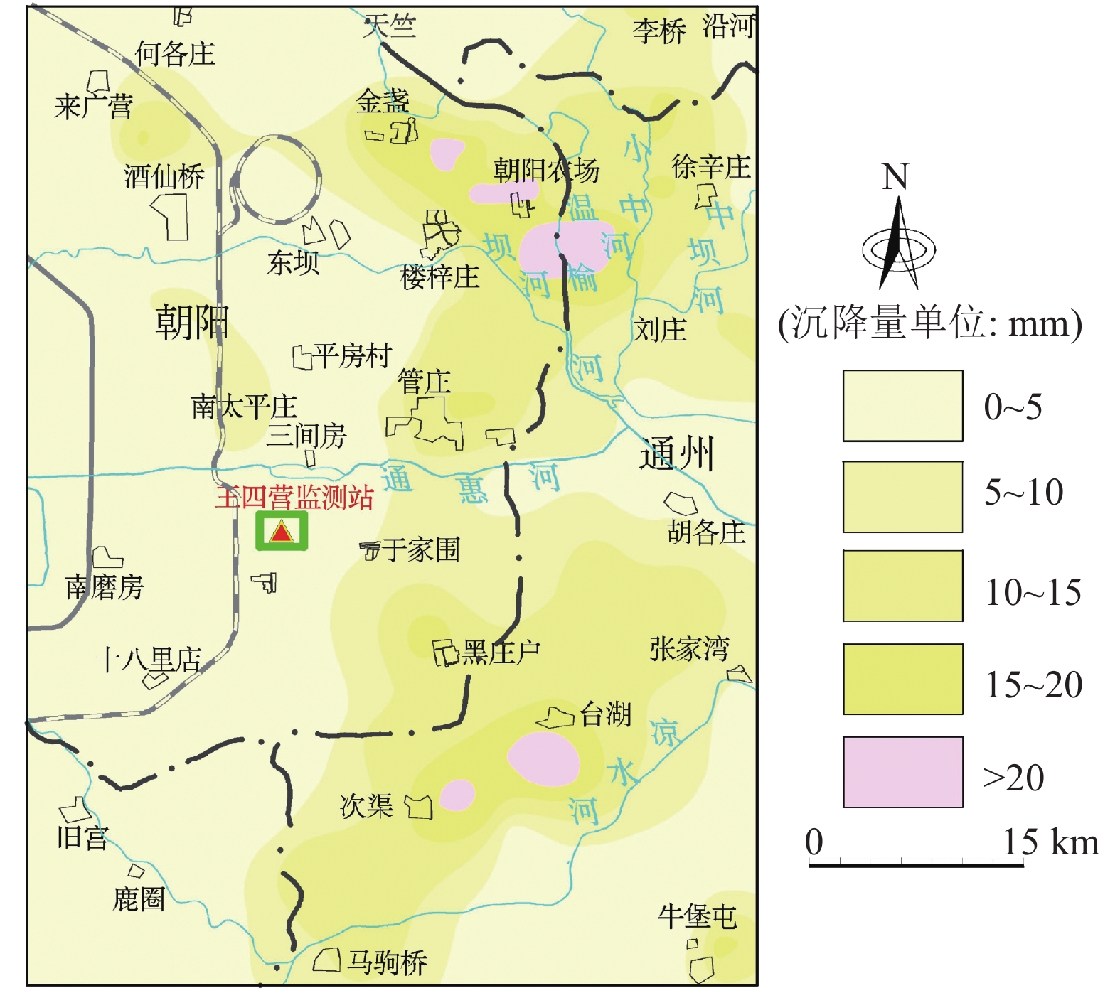
研究目的 为研究地面沉降演化规律及其沉降潜力,以北京王四营地区为例,结合多源精细化监测数据“由点到面”对该地区地面沉降特征进行分析和对比研究。
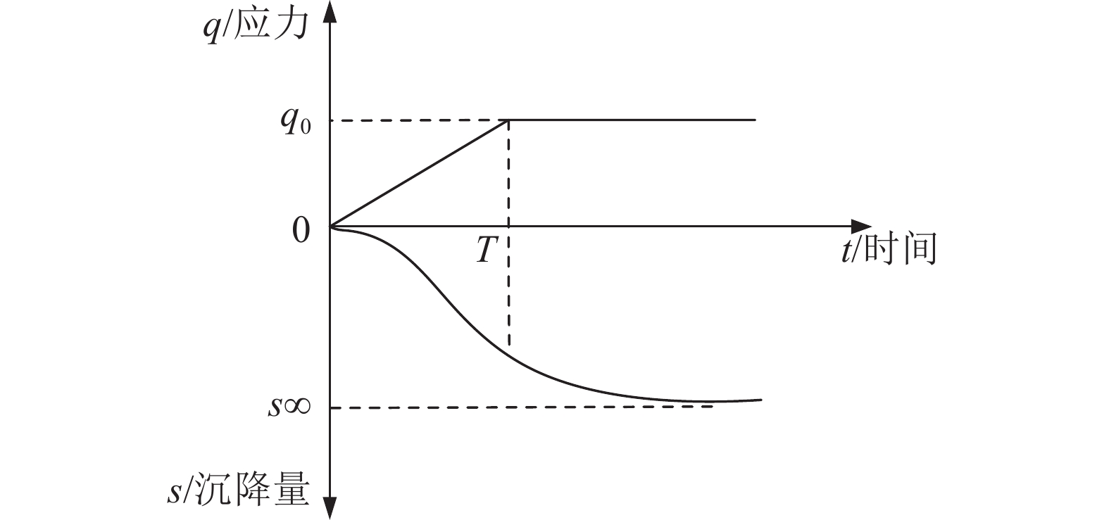
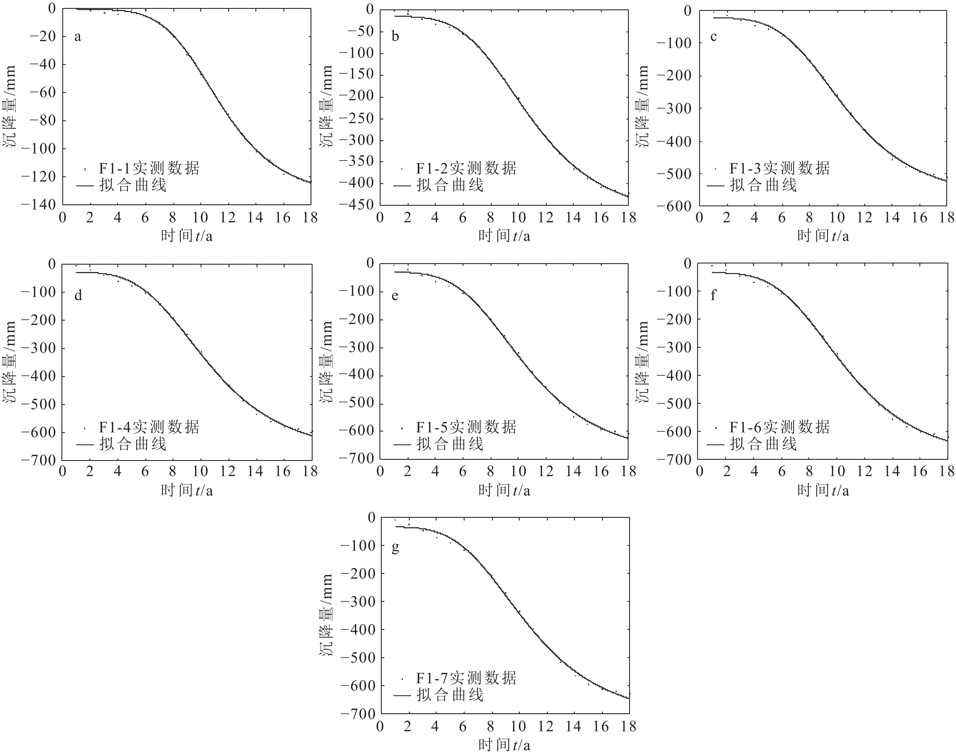
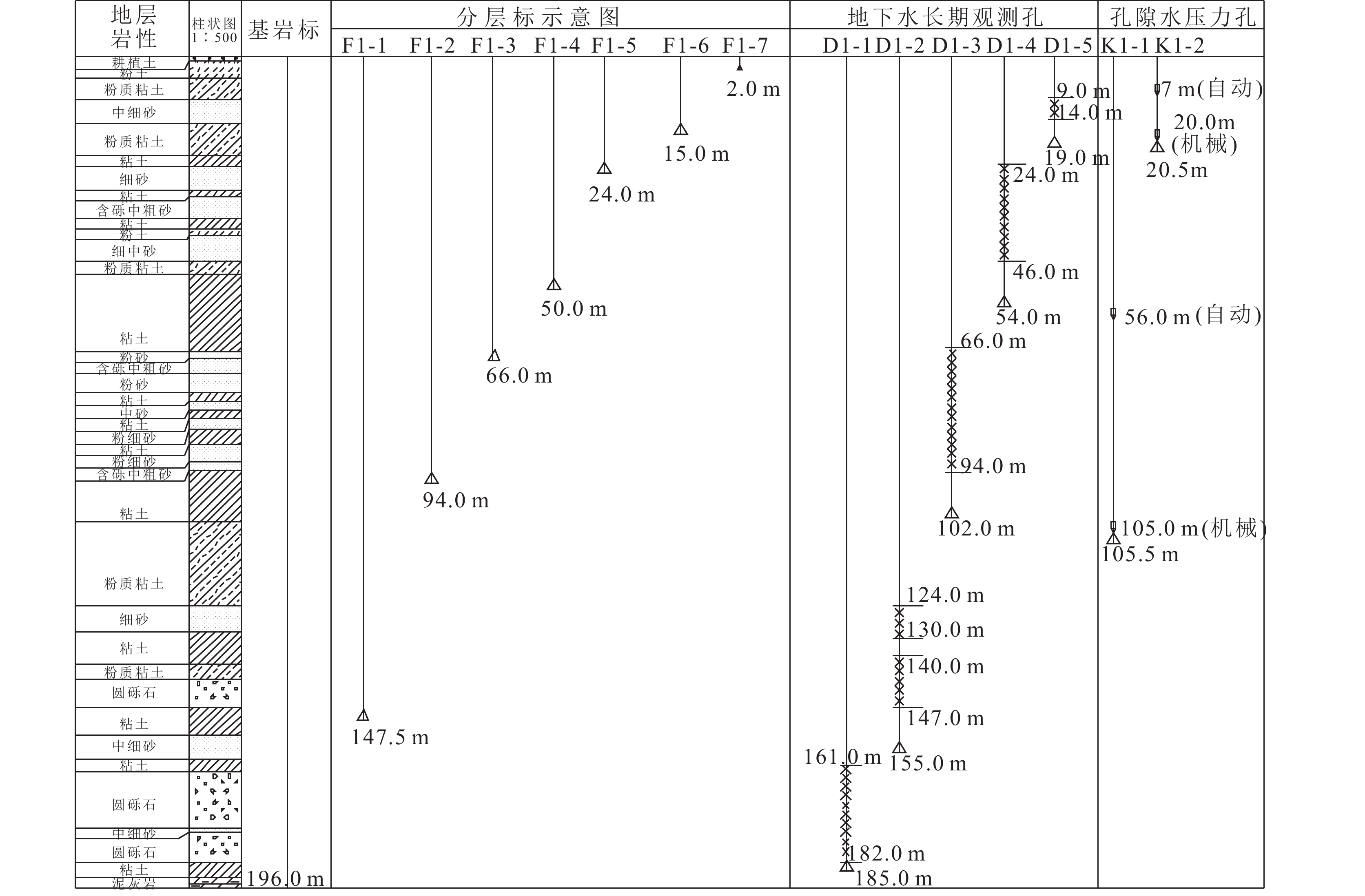
研究方法 引入成长曲线沉降模型,通过MATLAB构建了多源数据融合的地面沉降潜力评价模型。“点”上以王四营地面沉降站为依托,对分层沉降情况进行机理分析和预测;“面”上以区域水准测量和区域地下水位动态监测数据为依托,对区域沉降演化特征沉降潜力进行评价。
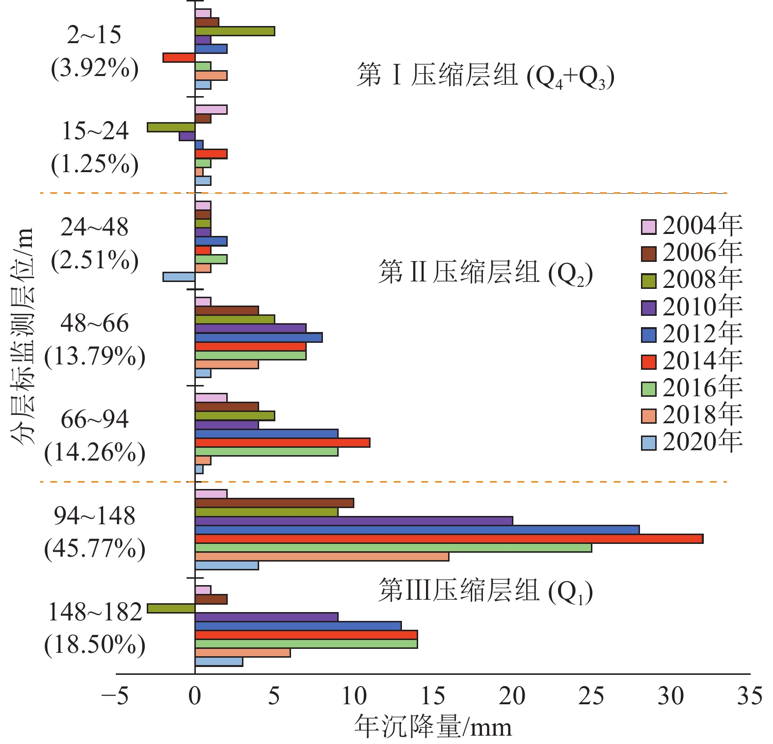
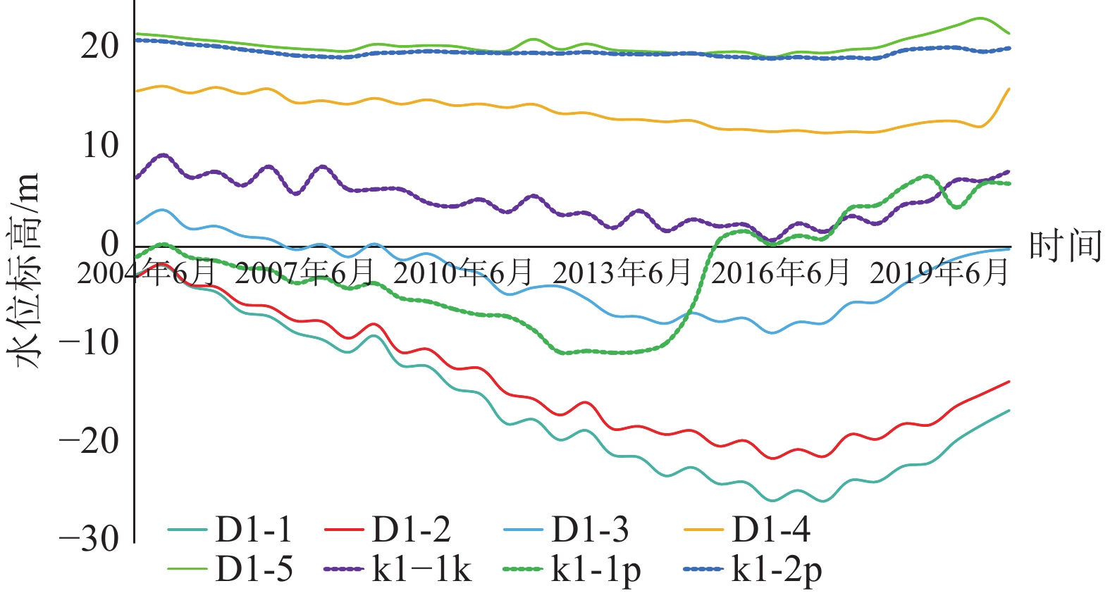
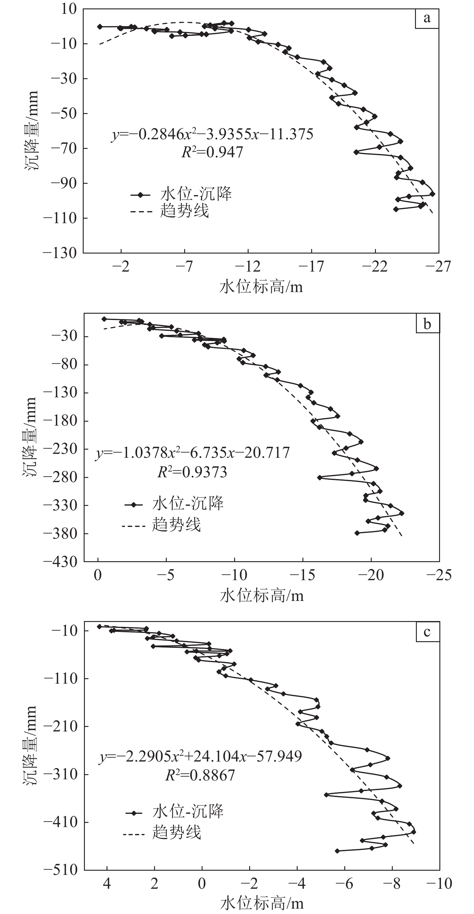
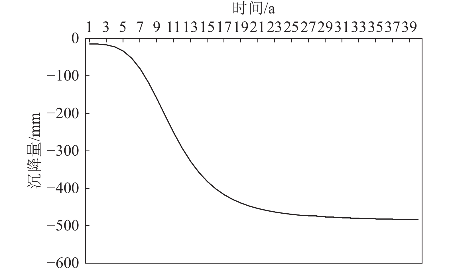
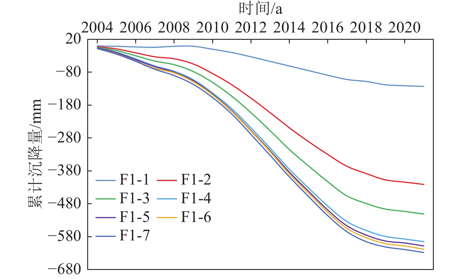
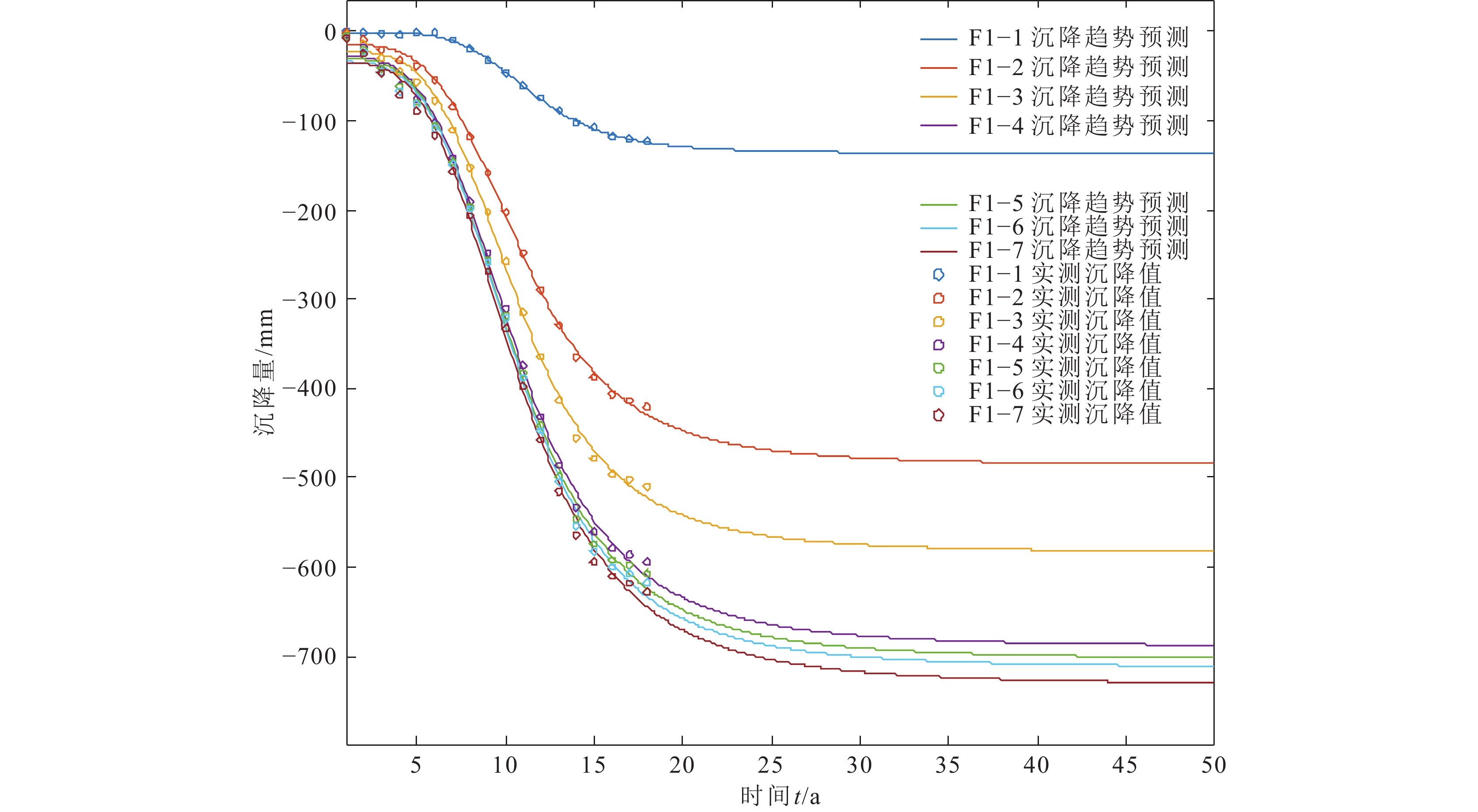
研究结果 ①地面沉降主要发生在粘性土层,地面沉降发育情况与粘性土含量成正比,王四营地区浅部地层中沉降量和沉降比例越来越小,而深部地层随着时间沉降量和沉降比例越来越大;丰水期地面沉降速率减缓,枯水期地面沉降速率明显增大;地面沉降和地下水位数据拟合后发现二者具有一定的相关性,随着水位降幅的增大,相关性也随之增大,二者呈正相关。②基岩标-分层标静力水准测量系统与人工水准测量系统对同一监测点数据互校后的误差值非常接近,符合正态分布规律。③预测未来地面沉降,垂向上随着时间的增长,各地层地面沉降开始逐渐衰减,但地层整体残余沉降量仍有100 mm左右的发展空间,中深部地层是未来地面沉降发生的主要优势层位,沉降潜力较大;横向上,未来地面沉降趋势与现阶段一致,但速率整体呈减缓趋势。
结论 王四营地区深部地层是主要的沉降“优势”层位,地面沉降所表现出的季节性形变特征与地下水位动态变化趋势有较高相关性,未来该地区沉降将持续减缓。
Abstract:Objective In order to research the evolution law of land subsidence and its subsidence potential,take the Wangsiying area in Beijing as an example,the characteristics of land subsidence in Wangsiying area "from point to surface" are analyzed and compared with multi−source fine monitoring data.
Methods The growth curve land subsidence model is introduced, and the land subsidence potential evaluation model based on multi−source data fusion is constructed by MATLAB.Based on Wangsiying ground land subsidence station, the mechanism analysis and prediction of layered land subsidence are carried out on "point"; Based on the regional leveling and dynamic monitoring data of regional groundwater level, the regional land subsidence evolution characteristics and land subsidence potential are evaluated.
Results (1) The land subsidence mainly occurs in the cohesive soil layer, and the development of land subsidence is directly proportional to the content of cohesive soil. The land subsidence amount and the land subsidence ratio of the shallow strata in Wangsiying area are getting smaller and smaller, while the land subsidence amount and the land subsidence ratio of the deep strata are getting larger and larger with time; The land subsidence rate slows down in the wet season and increases significantly in the dry season; After fitting the data of land subsidence and groundwater level, it is found that there is a certain correlation between them. The correlation increases with the increase of water level decline, and the correlation is positive; The development of land subsidence in Wangsiying area is relatively high,and the differential subsidence in the whole area is also very obvious. (2) The error values of the static leveling system of bedrock level and layered level and the manual leveling system for the data of the same monitoring point are very close to each other and conform to the normal distribution law. (3) It is predicted that the future land subsidence will be vertical. With the increase of time, the land subsidence of each layer will gradually decline, but the overall residual subsidence of the stratum still has a development space of about 100 mm. The middle and deep strata are the main "dominant strata" for the future land subsidence, and the land subsidence potential is large; Horizontally, the trend of land subsidence in the future is consistent with that in the current stage, but the overall rate is slowing down.
Conclusions The deep strata in Wangsiying area are the main subsidence "advantageous" layers, and the seasonal deformation characteristics of land subsidence are highly correlated with the dynamic changes in groundwater level. In the future, the land subsidence in this area will continue to slow down.
-
Key words:
- data fusion /
- land subsidence /
- evolution law /
- potential prediction /
- Beijing
-

-
表 1 不同监测方法与水准测量互校差值
Table 1. Differences after mutual calibration of different monitoring methods and levelingt
监测方法对比 两种监测方法互校后的差值/mm 基岩标−分层标与
水准测量对比−0.368 0.559 0.19 −0.13 −0.169 0.847 5.868 3.681 −1.485 0.969 −1.082 0.407 −1.909 −0.737 2.096 −0.424 −1.399 2.138 −2.144 1.957 −0.886 −1.25 1.639 −0.112  下载: 导出CSV
表 2 王四营站各分层标沉降潜力预测模型参数
Table 2. Parameters of the land subsidence potential prediction model of each layered standard at Wangsiying Station
分层标 F1-1 F1-2 F1-3 F1-4 F1-5 F1-6 F1-7 地层 中细砂 粘土 粘土 细砂 中粗砂 粘土 粘土 中粗砂 粘土 粉粘 粉土 中细砂 观测层位埋深/m 147.60~185.30 94.00~147.60 66.00~94.00 48.00~66.00 24.00~48.00 15.00~24.00 2.00~15.00 观测层初始厚度/m 37.7 53.5 28 18 24 9 13 当前标杆沉降量 −123 −421 −511 −595 −608 −618 −628 当前各层累计沉降量/mm −123 −298 −90 −84 −13 −10 −10 当前累计沉降量占总沉降百分比 19.59% 47.45% 14.33% 13.38% 2.07% 1.59% 1.59% 模型参数
(见公式(3))A1 −0.6717 −14.66 −22.4 −28.01 −30.01 −33.79 −34.18 A2 −136.3 −485.7 −583.4 −689.4 −703.3 −712.9 −731.9 p 5.14 4.03 4.05 3.802 3.816 3.855 3.72 t0 11.45 10.95 10.69 10.63 10.6 10.64 10.64 评价参数 相关系数R2 0.9987 0.9986 0.9979 0.9974 0.9973 0.9972 0.9969 误差项自由度dfe 14 14 14 14 14 14 14 均方根rmse 1.9668 6.6205 9.8388 12.6073 13.0732 13.5393 14.2547 预测稳定阶段 标杆沉降量/mm −136.231 −484.667 −582.317 −687.569 −701.496 −711.162 −729.700 各层预测累计沉降量/mm −136.231 −348.437 −97.650 −105.252 −13.926 −9.666 −18.539 各层预测累计沉降占
总沉降百分比18.67% 47.75% 13.38% 14.42% 1.91% 1.32% 2.54% 各层残余沉降量/mm −13.2305 −50.4365 −7.6499 −21.2523 −0.9264 0.334 −8.5387
下载: 导出CSV
表 3 2021年与2022年实测沉降量与模型预测沉降量对比
Table 3. Comparison between measured land subsidence and model predicted land subsidence in 2021 and 2022
点号 2021年 差值 2022年 差值 实测值/mm 预测值/mm 实测值/mm 预测值/mm 点1 −58.50 −57.42 −1.08 −44.60 −42.67 −1.93 点2 −30.90 −28.96 −1.94 −24.00 −23.01 −0.99 点3 −56.20 −53.56 −2.64 −50.00 −47.96 −2.04 点4 −51.20 −52.43 1.23 −36.50 −36.18 −0.32 点5 −40.00 −38.07 −1.93 −37.13 −36.00 −1.13 点6 −3.80 −5.69 1.89 −0.30 −2.63 2.33 点7 −5.70 −4.21 −1.49 −3.56 −5.13 1.57 点8 −13.90 −14.90 1.00 −11.60 −11.03 −0.57
下载: 导出CSV
-
[1] Das B M. 1983. Advanced soil mechanics[M]. New York: McGraw−Hill Book Company.
[2] Gompertz B. 1825. On the function expressive of the law of human mortality and on a new method of determining the value of life contingencies[J]. Philosophical Transactions of the Royal Society of London. Series A. Mathematical and Physical Sciences: 513−585.
[3] Karim M R. 2000. Analysis of Biot’s consolidation using element free galerkin method[D]. Singapore: National University of Singapore: 1−98.
[4] Beijing Hydrogeological Engineering Geological Brigade (Beijing Geological Environment Monitoring Station). 2018. Ground subsidence in Beijing[M]. Beijing: Geological Publishing House (in Chinese).
[5] Yu H R, Gong H L, Chen B B, et al. 2020. Progress and reflection on land subsidence research in the Beijing−Tianjin−Hebei region[J]. Surveying and Mapping Science, 45(4): 125−133, 141 (in Chinese with English abstract).
[6] Guo H P, Li W P, Wang L Y, et al. 2021. Current situation and research prospect of land subsidence driven by groundwater level in the North China Plain[J]. Hydrogeology and Engineering Geology, 48(3): 162−171 (in Chinese with English abstract).
[7] Luo Y, Ye S J, Wu J C, et al. 2015. Analysis of soil deformation characteristics under the condition of significant groundwater level rise in Shanghai[J]. Journal of Geological Sciences, 21(2): 243−254 (in Chinese with English abstract).
[8] Li Z F, Zhou Z F, Li M Y, et al. 2017. Hydraulic parameter response law during water release process in weakly permeable layers[J]. Journal of Hohai University (Natural Science Edition), 45(4): 340−344 (in Chinese with English abstract).
[9] Zhu W W. 1991. Study on hydraulic and compressive properties of overflowing aquifer systems[J]. Journal of Earth Sciences (China University of Geosciences), (1): 95−104 (in Chinese with English abstract).
[10] Wu Q, Xie H L, Zhao Z M, et al. 2006. Study on the deformation mechanism of weakly permeable layers[J]. Journal of Beijing University of Science and Technology, (3): 207−210 (in Chinese with English abstract).
[11] Sun J. 1992. Overflow and cohesive soil water release in deep pore water resource evaluation[J]. Geology of Anhui Province, (3): 46−50 (in Chinese with English abstract).
[12] Wang W, Lu T H. 2007. Model analysis of soft foundation settlement prediction based on Weibull curve[J]. Geotechnical Mechanics, 28(4): 803−807 (in Chinese with English abstract).
[13] Zhu Z D, Zhou L H. 2009. Application of logistic model for predicting the whole process settlement of soft soil roadbeds[J]. Journal of Geotechnical Engineering, 31(6): 965−969 (in Chinese with English abstract).
[14] Yu C, Liu S Y. 2005. Application of Gompertz Model for predicting embankment settlement[J]. Geotechnical Mechanics, 26(1): 82−86 (in Chinese with English abstract).
[15] Mei G X, Zai J M, Yin Z Z, et al. 2004. Proof of the "S" shape of the settlement time curve[J]. Geotechnical Mechanics, 25(1): 20−22 (in Chinese with English abstract).
[16] Yang T, Li G W, Yang W Q. 2004. Prediction of settlement of graded embankment based on hyperbolic method[J]. Geotechnical Mechanics, 25(10): 1551−1554 (in Chinese with English abstract).
[17] Yang T, Yin Z Z. 1998. Composite constitutive finite element analysis of settlement of composite foundation[J]. Geotechnical Mechanics, 19(2): 19−25 (in Chinese with English abstract).
[18] Liu H, Cui W J, Luo Y, et al. 2022. Changes in land subsidence, groundwater level, and pore water pressure in Tianzhu, Beijing based on layered monitoring[J]. Geological Bulletin of China, 41(4): 692−701 (in Chinese with English abstract).
[19] Lei K C, Ma F S, Luo Y, et al. 2019. Stability study of reference datum for land subsidence monitoring network in Beijing plain area[J]. Advances in Geophysics, 34(5): 1757−1769 (in Chinese with English abstract).
[20] Lu T H. 2002. Soil mechanics[M]. Nanjing: Hohai University Publishing House (in Chinese).
[21] Mei G X, Zai J M, Yin Z Z, et al. 2004. Proof of S−shaped settlement time curve from the perspective of one−dimensional consolidation theory[J]. Geotechnical Mechanics, (1): 20−22 (in Chinese with English abstract).
[22] 北京市水文地质工程地质大队(北京市地质环境监测总站). 2018. 北京地面沉降[M]. 北京: 地质出版社.
[23] 郭海朋, 李文鹏, 王丽亚, 等. 2021. 华北平原地下水位驱动下的地面沉降现状与研究展望[J]. 水文地质工程地质, 48(3): 162−171.
[24] 雷坤超, 马凤山, 罗勇, 等. 2019. 北京平原区地面沉降水准监测网参考基准稳定性研究[J]. 地球物理学进展, 34(5): 1757−1769. doi: 10.6038/pg2019CC0303
[25] 李兆峰, 周志芳, 李明远, 等. 2017. 弱透水层释水过程中水力参数响应规律[J]. 河海大学学报(自然科学版), 45(4): 340−344.
[26] 刘贺, 崔文君, 罗勇, 等. 2022. 基于分层监测的北京天竺地面沉降、地下水位与孔隙水压力变化规律[J]. 地质通报, 41(4): 692−701. doi: 10.12097/j.issn.1671-2552.2022.04.013
[27] 卢廷浩. 2002. 土力学[M]. 南京: 河海大学出版社.
[28] 罗跃, 叶淑君, 吴吉春, 等. 2015. 上海市地下水位大幅抬升条件下土层变形特征分析[J]. 高校地质学报, 21(2): 243−254.
[29] 梅国雄, 宰金珉, 殷宗泽, 等. 2004. 沉降–时间曲线呈“S”型的证明[J]. 岩土力学, 25(1): 20−22. doi: 10.3969/j.issn.1000-7598.2004.01.005
[30] 孙健. 1992. 深层孔隙水资源评价中的越流和粘性土释水[J]. 安徽地质, (3): 46−50.
[31] 王伟, 卢廷浩. 2007. 基于Weibull曲线的软基沉降预测出模型分析[J]. 岩土力学, 28(4): 803−807. doi: 10.3969/j.issn.1000-7598.2007.04.033
[32] 武强, 谢海澜, 赵增敏, 等. 2006. 弱透水层变形机理的研究[J]. 北京科技大学学报, (3): 207−210.
[33] 杨涛, 李国维, 杨伟清. 2004. 基于双曲线法的分级填筑路堤沉降预测[J]. 岩土力学, 25(10): 1551−1554. doi: 10.3969/j.issn.1000-7598.2004.10.008
[34] 杨涛, 殷宗泽. 1998. 复合地基沉降的复合本构有限元分析[J]. 岩土力学, 19(2): 19−25.
[35] 于海若, 宫辉力, 陈蓓蓓, 等. 2020. 京津冀地区地面沉降研究进展与思考[J]. 测绘科学, 45(4): 125−133,141.
[36] 余闯, 刘松玉. 2005. 路堤沉降预测的Gompertz模型应用研究[J]. 岩土力学, 26(1): 82−86. doi: 10.3969/j.issn.1000-7598.2005.01.017
[37] 朱伟武. 1991. 越流含水层系统水力性质及压密性质的研究[J]. 地球科学-中国地质大学学报, (1): 95−104.
[38] 朱志铎, 周礼红. 2009. 软土路基全过程沉降预测的Logistic模型应用研究[J]. 岩土工程学报, 31(6): 965−969. doi: 10.3321/j.issn:1000-4548.2009.06.023
-


图(15)
表(3)
计量
- 文章访问数: 68
- PDF下载数: 24
- 施引文献: 0