

LAND USE CHANGES AND SIMULATION PREDICTION IN DALING RIVER BASIN BASED ON CA-MARKOV MODEL
-
摘要:
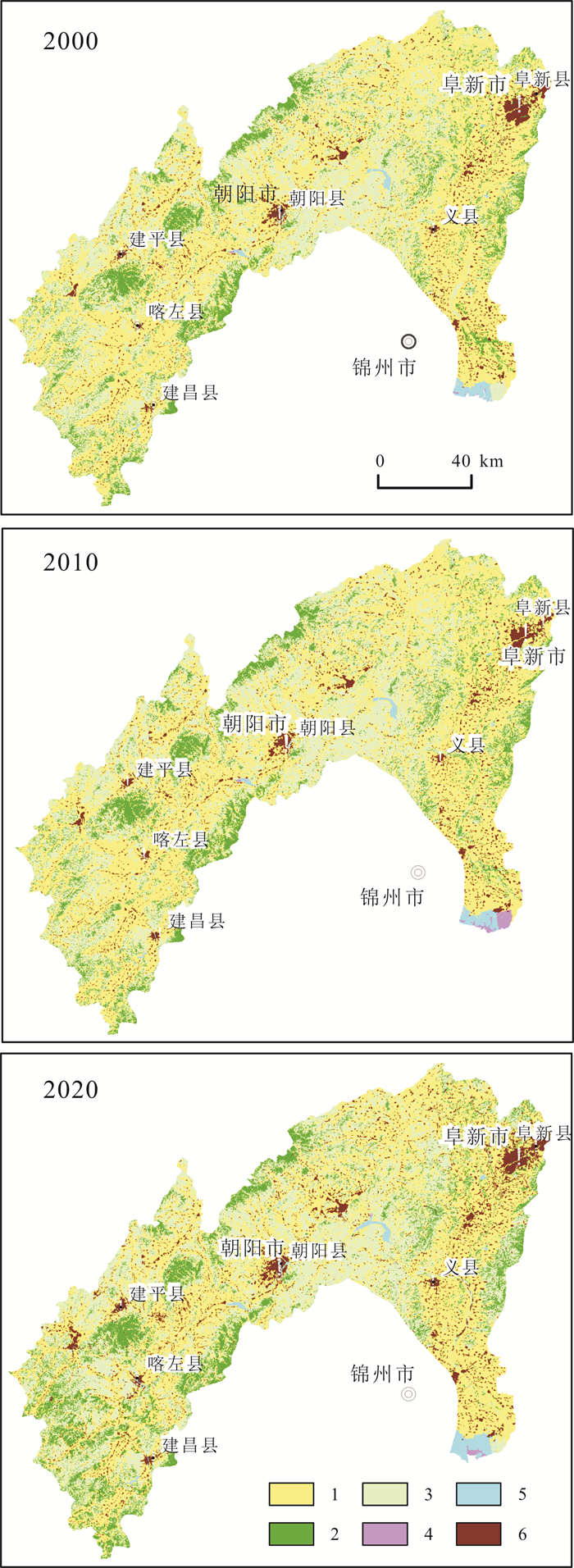
基于大凌河流域2000、2010和2020年3期土地利用数据, 采用土地利用动态度、土地利用程度、土地利用转移矩阵等方法分析过去20年来研究区土地利用变化规律, 并基于元胞自动机-马尔可夫(CA-Markov)模型模拟预测研究区2030年土地利用格局.结果表明: 2000-2020年大凌河流域土地利用以耕地和草地为主, 二者占比超过80%.近20年间, 研究区内林地、草地和建设用地面积不断增加, 耕地面积持续减少, 且减少的速度在加快, 前后两个10年分别减少了132.85和1360.13 km2.2000-2020年间, 土地综合利用动态度由43.53%降低为10.36%, 处于降低趋势.建设用地动态度由0.11%增加至4.99%, 湿地动态度由86.32%变为-7.22%, 土地利用程度综合指数由262.53变为259.91, 表明大凌河流域近20年土地处于衰退期.基于CA-Markov模型预测大凌河流域2030年土地利用格局, 模拟精度Kappa系数为0.8835.预测结果表明, 2030年, 大凌河流域耕地面积将进一步减少1 699.92 km2, 主要变为草地、建设用地和林地.
Abstract:According to the land use data of Daling River Basin in 2000, 2010 and 2020, the land use dynamic degree, land use degree and land use transfer matrix are adapted to analyze the change rule of land use in the area in the past 20 years, and the land use patterns in 2030 are simulated and predicted based on the CA-Markov model. The results show that the cultivated land and grassland are dominated during 2000-2020, accounting for over 80% of the total land use in Daling River Basin. In the past 20 years, the area of forest land, grassland and construction land have been continuously increasing, while the area of farm land has been decreasing, and the rate of decline is accelerating, with the decrease of 132.85 and 1360.13 km2 respectively in the first and second decades. The dynamic degree of comprehensive land use reduces from 43.53% to 10.36%, showing a decreasing trend. The dynamic degree of construction land increases from 0.11% to 4.99%, and that of wetland changes from 86.32% to -7.22%. The comprehensive index of land use degree changes from 262.53 to 259.91, indicating that the land in Daling River Basin is in decline in recent 20 years. The land use patterns of the area in 2030 are predicted based on CA-Markov model, with the simulation accuracy Kappa coefficient of 0.8835. The prediction results reveal that the farm land will further decrease by 1699.92 km2 in 2030, mainly changing into grassland, construction land and forest land.
-
Key words:
- Daling River Basin /
- land use /
- spatiotemporal pattern /
- simulation prediction /
- CA-Markov model /
- Northeast China
-

-
表 1 土地利用类型分类表
Table 1. Classification of land use types
类型 含义 耕地 水田、灌溉旱地、雨养旱地、菜地、牧草种植地、大棚用地、茶园 林地 落叶阔叶林、常绿阔叶林、落叶针叶林、常绿针叶林、混交林和疏林地 草地 草原、草甸、稀树草原、荒漠草原、城市人工草地 湿地 内陆沼泽、湖泊沼泽、河流洪泛湿地、森林/灌木湿地、泥炭沼泽、红树林、盐沼 水体 江河、湖泊、水库、坑塘 建设用地 城镇等各类居民地、工矿、交通设施 裸地 荒漠、沙地、砾石地、裸岩、盐碱地  下载: 导出CSV
表 2 土地利用类型及分级表
Table 2. Land use types and grading indexes
类别 未利用地级 林、草、水地级 农用地级 城镇聚落地级 土地利用类型 裸地 林地、草地、湿地、水体 耕地 建设用地 指标 1 2 3 4
下载: 导出CSV
表 3 大凌河流域土地利用面积统计表
Table 3. Statistics of land use area in Daling River Basin
类别 面积/km2 占比/% 面积变化/km2 2000年 2010年 2020年 2000年 2010年 2020年 2000-2010年 2010-2020年 2000-2020年 耕地 11024.48 10891.63 9531.50 53.23 52.59 46.02 -132.85 -1360.13 -1492.97 林地 2309.12 2342.50 2656.09 11.15 11.31 12.82 33.39 313.59 346.97 草地 6236.09 6282.03 6852.26 30.11 30.33 33.09 45.94 570.23 616.17 湿地 6.57 63.33 17.59 0.03 0.31 0.08 56.75 -45.74 11.01 水体 152.46 156.90 235.37 0.74 0.76 1.14 4.44 78.47 82.91 建设用地 954.21 964.80 1446.44 4.61 4.66 6.98 10.58 481.65 492.23
下载: 导出CSV
表 4 大凌河流域土地利用动态度统计表
Table 4. Dynamic degree statistics of land use in Daling River Basin
时段 耕地 林地 草地 湿地 水体 建设用地 综合动态度 2000-2010年 -0.12 0.14 0.07 86.32 0.29 0.11 43.53 2010-2020年 -1.25 1.34 0.91 -7.22 5.00 4.99 10.36 2000-2020年 -0.68 0.75 0.49 8.38 2.72 2.58 15.60 单位: %.
下载: 导出CSV
表 5 大凌河流域土地利用综合指数统计表
Table 5. Comprehensive land use index of Daling River Basin
时间 2000年 2010年 2020年 土地利用综合指数/% 262.53 261.93 259.91 时段 2000-2010年 2010-2020年 2000-2020年 土地利用程度变化量/% -0.6 -2.02 -2.62
下载: 导出CSV
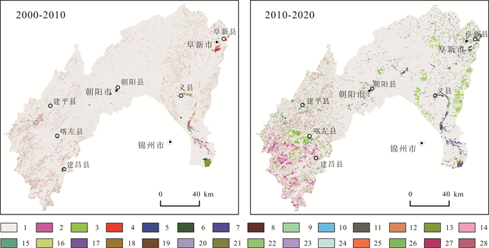
表 6 大凌河流域2000-2010年土地利用变化矩阵
Table 6. Land use change matrix of Daling River Basin during 2000-2010
2000年\2010年 耕地 林地 草地 湿地 水体 建设用地 耕地 10802.64 54.96 130.74 1.54 0.63 33.34 林地 7.30 1988.66 312.38 0.04 0.02 0.10 草地 45.48 295.98 5824.93 41.92 1.82 25.16 湿地 0.00 0.00 0.00 6.57 0.00 0.00 水体 3.66 0.38 0.96 0.00 147.42 0.03 建设用地 32.32 2.39 12.77 0.00 0.55 906.15 面积单位: km2.
下载: 导出CSV
表 7 大凌河流域2010-2020年土地利用变化矩阵
Table 7. Land use change matrix of Daling River Basin during 2010-2020
2010年\2020年 耕地 林地 草地 湿地 水体 建设用地 耕地 9255.38 403.15 723.68 1.56 34.72 473.15 林地 77.74 2057.00 200.37 0.00 0.86 6.54 草地 143.18 194.08 5896.47 0.42 3.64 44.25 湿地 14.89 0.00 24.88 7.34 15.76 0.46 水体 0.05 0.05 0.05 0.05 0.05 0.05 建设用地 0.05 0.06 0.06 0.00 0.06 0.06 面积单位: km2.
下载: 导出CSV
表 8 大凌河流域2020-2030年土地利用变化矩阵
Table 8. Land use change matrix of Daling River Basin during 2020-2030
2020年\2030年 耕地 林地 草地 湿地 水体 建设用地 耕地 7831.32 454.19 630.42 0.00 43.92 571.65 林地 0.00 2629.90 26.20 0.00 0.00 0.00 草地 0.00 255.22 6494.02 0.00 0.00 103.01 湿地 0.26 0.00 1.07 15.01 1.25 0.00 水体 0.00 0.00 0.00 4.14 231.19 0.05 建设用地 0.00 0.00 0.00 0.00 0.11 1446.34 面积单位: km2.
下载: 导出CSV
-
[1] 刘纪远, 宁佳, 匡文慧, 等. 2010-2015年中国土地利用变化的时空格局与新特征[J]. 地理学报, 2018, 73(5): 789-802. https://www.cnki.com.cn/Article/CJFDTOTAL-DLXB201805002.htm
Liu J Y, Ning J, Kuang W H, et al. Spatio-temporal patterns and characteristics of land-use change in China during 2010-2015[J]. Acta Geographica Sinica, 2018, 73(5): 789-802. https://www.cnki.com.cn/Article/CJFDTOTAL-DLXB201805002.htm
[2] 侯西勇, 常斌, 于信芳. 基于CA-Markov的河西走廊土地利用变化研究[J]. 农业工程学报, 2004, 20(5): 286-291. https://www.cnki.com.cn/Article/CJFDTOTAL-NYGU200405065.htm
Hou X Y, Chang B, Yu X F. Land use change in Hexi Corridor based on CA-Markov methods[J]. Transactions of the Chinese Society of Agricultural Engineering, 2004, 20(5): 286-291. https://www.cnki.com.cn/Article/CJFDTOTAL-NYGU200405065.htm
[3] 陈龙泉, 郑海金. 基于Markov-CA的土地利用/土地覆盖变化动态模型研究[J]. 测绘信息与工程, 2004, 29(1): 36-38. https://www.cnki.com.cn/Article/CJFDTOTAL-CHXG200401023.htm
Chen L Q, Zheng H J. Dynamic models of land use/land cover changes based on Markov-CA[J]. Journal of Geomatics, 2004, 29(1): 36-38. https://www.cnki.com.cn/Article/CJFDTOTAL-CHXG200401023.htm
[4] 汤洁, 汪雪格, 李昭阳, 等. 基于CA-Markov模型的吉林省西部土地利用景观格局变化趋势预测[J]. 吉林大学学报(地球科学版), 2010, 40(2): 405-411. https://www.cnki.com.cn/Article/CJFDTOTAL-CCDZ201002026.htm
Tang J, Wang X G, Li Z Y, et al. The tendency forecast on land use landscape pattern change in western Jilin Province based on CA-Markov model[J]. Journal of Jilin University (Earth Science Edition), 2010, 40(2): 405-411. https://www.cnki.com.cn/Article/CJFDTOTAL-CCDZ201002026.htm
[5] 马梓策, 于红博, 张巧凤, 等. 基于CA-Markov模型的锡林河流域土地利用变化及预测分析[J]. 西北林学院学报, 2020, 35(2): 169-177. https://www.cnki.com.cn/Article/CJFDTOTAL-XBLX202002026.htm
Ma Z C, Yu H B, Zhang Q F, et al. Land use change and forecast analysis in the Xilin River Basin based on CA-Markov model[J]. Journal of Northwest Forestry University, 2020, 35(2): 169-177. https://www.cnki.com.cn/Article/CJFDTOTAL-XBLX202002026.htm
[6] 张永民, 赵士洞, Verburg P H. CLUE-S模型及其在奈曼旗土地利用时空动态变化模拟中的应用[J]. 自然资源学报, 2003, 18(3): 310-318. doi: 10.3321/j.issn:1000-3037.2003.03.008
Zhang Y M, Zhao S D, Verburg P H. CLUE-S and its application for simulating temporal and spatial change of land use in Naiman Banner[J]. Journal of Natural Resources, 2003, 18(3): 310-318. doi: 10.3321/j.issn:1000-3037.2003.03.008
[7] 涂小松, 濮励杰, 吴骏, 等. 基于SLEUTH模型的无锡市区土地利用变化情景模拟[J]. 长江流域资源与环境, 2008, 17(6): 860-865. https://www.cnki.com.cn/Article/CJFDTOTAL-CJLY200806006.htm
Tu X S, Pu L J, Wu J, et al. Using SLUETH model to simulate land use change scenarios in Wuxi district[J]. Resources and Environment in the Yangtze Basin, 2008, 17(6): 860-865. https://www.cnki.com.cn/Article/CJFDTOTAL-CJLY200806006.htm
[8] 陈海, 王涛, 梁小英, 等. 基于MAS的农户土地利用模型构建与模拟——以陕西省米脂县孟岔村为例[J]. 地理学报, 2009, 64(12): 1448-1456. https://www.cnki.com.cn/Article/CJFDTOTAL-DLXB200912008.htm
Chen H, Wang T, Liang X Y, et al. Simulation and application of household's LUCC based on a multi-agent system: A case study for Mengcha Village of Mizhi County of Shaanxi Province[J]. Acta Geographica Sinica, 2009, 64(12): 1448-1456. https://www.cnki.com.cn/Article/CJFDTOTAL-DLXB200912008.htm
[9] Muller M R, Middleton J. A Markov model of land-use change dynamics in the Niagara Region, Ontario, Canada[J]. Landscape Ecology, 1994, 9(2): 151-157.
[10] Subedi P, Subedi K, Thapa B. Application of a hybrid cellular automaton-Markov (CA-Markov) model in land-use change prediction: A case study of Saddle Creek Drainage Basin, Florida[J]. Applied Ecology and Environmental Sciences, 2013, 1(6): 126-132. doi: 10.12691/aees-1-6-5
[11] Halmy M W A, Gessler P E, Hicke J A, et al. Land use/land cover change detection and prediction in the north-western coastal desert of Egypt using Markov-CA[J]. Applied Geography, 2015, 63: 101-112.
[12] 于涛, 沈浩, 仲嘉亮. 基于CA-Markov模型的新疆克州土地利用动态模拟研究[J]. 新疆环境保护, 2008, 30(1): 11-14. https://www.cnki.com.cn/Article/CJFDTOTAL-XJHB200801002.htm
Yu T, Shen H, Zhong J L. Dynamic analogue research of land utilization of Kizilsu Kirgiz Autonomous Prefecture Xinjiang base on CA-Markov model[J]. Environmental Protection of Xinjiang, 2008, 30(1): 11-14. https://www.cnki.com.cn/Article/CJFDTOTAL-XJHB200801002.htm
[13] 杨国清, 刘耀林, 吴志峰. 基于CA-Markov模型的土地利用格局变化研究[J]. 武汉大学学报(信息科学版), 2007, 32(5): 414-418. https://www.cnki.com.cn/Article/CJFDTOTAL-WHCH200705011.htm
Yang G Q, Liu Y L, Wu Z F. Analysis and simulation of land-use temporal and spatial pattern based on CA-Markov model[J]. Geomatics and Information Science of Wuhan University, 2007, 32(5): 414-418. https://www.cnki.com.cn/Article/CJFDTOTAL-WHCH200705011.htm
[14] 施成超, 周英, 刘滢, 等. 基于CA-Markov模型的云南省德宏州土地利用变化和预测研究[J]. 西部林业科学, 2022, 51(1): 102-109. https://www.cnki.com.cn/Article/CJFDTOTAL-YNLK202201016.htm
Shi C C, Zhou Y, Liu Y, et al. Modeling and prediction of land use change in Dehong Prefecture of Yunnan Province based on CA-Markov model[J]. Journal of West China Forestry Science, 2022, 51(1): 102-109. https://www.cnki.com.cn/Article/CJFDTOTAL-YNLK202201016.htm
[15] 张晓娟, 周启刚, 王兆林, 等. 基于MCE-CA-Markov的三峡库区土地利用演变模拟及预测[J]. 农业工程学报, 2017, 33(19): 268-277. https://www.cnki.com.cn/Article/CJFDTOTAL-NYGU201719035.htm
Zhang X J, Zhou Q G, Wang Z L, et al. Simulation and prediction of land use change in Three Gorges reservoir area based on MCE-CA-Markov[J]. Transactions of the Chinese Society of Agricultural Engineering, 2017, 33(19): 268-277. https://www.cnki.com.cn/Article/CJFDTOTAL-NYGU201719035.htm
[16] 黎云云, 畅建霞, 王义民, 等. 基于CA-Markov模型的黄河流域土地利用模拟预测研究[J]. 西北农林科技大学学报(自然科学版), 2020, 48(12): 107-116. https://www.cnki.com.cn/Article/CJFDTOTAL-XBNY202012014.htm
Li Y Y, Chang J X, Wang Y M, et al. Land use simulation and prediction in the Yellow River Basin based on CA-Markov model[J]. Journal of Northwest A&F University (Natural Science Edition), 2020, 48(12): 107-116. https://www.cnki.com.cn/Article/CJFDTOTAL-XBNY202012014.htm
[17] 王禹浪, 孙军, 王文轶. 大、小凌河流域的古代文明与历史文化[J]. 黑龙江民族丛刊, 2008(1): 83-88. https://www.cnki.com.cn/Article/CJFDTOTAL-HLMZ200801018.htm
Wang Y L, Sun J, Wang W Y. Ancient civilization and culture along the Big and Small Ling River[J]. Heilongjiang National Series, 2008(1): 83-88. https://www.cnki.com.cn/Article/CJFDTOTAL-HLMZ200801018.htm
[18] 邸志强, 金洪涛, 苗英, 等. 辽西蓄水构造及找水方向[J]. 地质与资源, 2007, 16(2): 112-115. http://manu25.magtech.com.cn/Jweb_dzyzy/CN/abstract/abstract9436.shtml
Di Z Q, Jin H T, Miao Y, et al. Water storage structure and water search target in western Liaoning Province[J]. Geology and Resources, 2007, 16(2): 112-115. http://manu25.magtech.com.cn/Jweb_dzyzy/CN/abstract/abstract9436.shtml
[19] 裴亮, 陈晨, 戴激光, 等. 基于马尔科夫模型的大凌河流域土地利用/覆被变化趋势研究[J]. 土壤通报, 2017, 48(3): 525-531. https://www.cnki.com.cn/Article/CJFDTOTAL-TRTB201703003.htm
Pei L, Chen C, Dai J G, et al. Research on forecast trend of land use and land cover change in Daling River Basin based on Markov model[J]. Chinese Journal of Soil Science, 2017, 48(3): 525-531. https://www.cnki.com.cn/Article/CJFDTOTAL-TRTB201703003.htm
[20] 魏晶, 王涌翔, 吴钢, 等. 辽西大凌河流域土地利用变化及驱动力分析[J]. 生态环境, 2006, 15(3): 559-563. https://www.cnki.com.cn/Article/CJFDTOTAL-TRYJ200603025.htm
Wei J, Wang Y X, Wu G, et al. Driving forces analysis of land utilization in Dalinghe River watershed of western Liaoning Province during 1987-2002[J]. Ecology and Environment, 2006, 15(3): 559-563. https://www.cnki.com.cn/Article/CJFDTOTAL-TRYJ200603025.htm
[21] 陈军, 陈晋, 廖安平, 等. 全球地表覆盖遥感制图[M]. 北京: 科学出版社, 2016.
Chen J, Chen J, Liao A P, et al. Remote sensing mapping of global land cover[M]. Beijing: Science Press, 2016. (in Chinese)
[22] 王秀兰, 包玉海. 土地利用动态变化研究方法探讨[J]. 地理科学进展, 1999, 18(1): 81-87. https://www.cnki.com.cn/Article/CJFDTOTAL-DLKJ901.011.htm
Wang X L, Bao Y H. Study on the methods of land use dynamic change research[J]. Progress in Geography, 1999, 18(1): 81-87. https://www.cnki.com.cn/Article/CJFDTOTAL-DLKJ901.011.htm
[23] 朱会义, 李秀彬. 关于区域土地利用变化指数模型方法的讨论[J]. 地理学报, 2003, 58(5): 643-650. https://www.cnki.com.cn/Article/CJFDTOTAL-DLXB200305000.htm
Zhu H Y, Li X B. Discussion on the index method of regional land use change[J]. Acta Geographica Sinica, 2003, 58(5): 643-650. https://www.cnki.com.cn/Article/CJFDTOTAL-DLXB200305000.htm
[24] 杨佳佳, 张一鹤, 冯雨林, 等. 松嫩平原东部土地利用时空动态变化分析[J]. 地质与资源, 2020, 29(6): 627-634, 602. http://manu25.magtech.com.cn/Jweb_dzyzy/CN/abstract/abstract10257.shtml
Yang J J, Zhang Y H, Feng Y L, et al. Spatiotemporal dynamic change analysis of land use in eastern Songnen Plain[J]. Geology and Resources, 2020, 29(6): 627-634, 602. http://manu25.magtech.com.cn/Jweb_dzyzy/CN/abstract/abstract10257.shtml
[25] 张安定, 李德一, 王大鹏, 等. 山东半岛北部海岸带土地利用变化与驱动力——以龙口市为例[J]. 经济地理, 2007, 27(6): 1007-1010. https://www.cnki.com.cn/Article/CJFDTOTAL-JJDL200706031.htm
Zhang A D, Li D Y, Wang D P, et al. Analysis of land use dynamic changes and its driving forces in the north of Shandong Peninsula: Taking Longkou as an example[J]. Economic Geography, 2007, 27(6): 1007-1010. https://www.cnki.com.cn/Article/CJFDTOTAL-JJDL200706031.htm
[26] 张俊平, 李净. 基于CA-Markov模型的甘州区土地利用变化预测分析[J]. 中国农学通报, 2017, 33(4): 105-110. https://www.cnki.com.cn/Article/CJFDTOTAL-ZNTB201704019.htm
Zhang J P, Li J. Prediction and analysis of land use change based on CA-Markov model in Ganzhou District[J]. Chinese Agricultural Science Bulletin, 2017, 33(4): 105-110. https://www.cnki.com.cn/Article/CJFDTOTAL-ZNTB201704019.htm
[27] 刘淑燕, 余新晓, 李庆云, 等. 基于CA-Markov模型的黄土丘陵区土地利用变化[J]. 农业工程学报, 2010, 26(11): 297-303. https://www.cnki.com.cn/Article/CJFDTOTAL-NYGU201011053.htm
Liu S Y, Yu X X, Li Q Y, et al. Land use change in loess hilly region based on CA-Markov model[J]. Transactions of the Chinese Society of Agricultural Engineering, 2010, 26(11): 297-303. https://www.cnki.com.cn/Article/CJFDTOTAL-NYGU201011053.htm
[28] 何丹, 周璟, 高伟, 等. 基于CA-Markov模型的滇池流域土地利用变化动态模拟研究[J]. 北京大学学报(自然科学版), 2014, 50(6): 1095-1105. https://www.cnki.com.cn/Article/CJFDTOTAL-BJDZ201406014.htm
He D, Zhou J, Gao W, et al. An integrated CA-Markov model for dynamic simulation of land use change in Lake Dianchi watershed[J]. Acta Scientiarum Naturalium Universitatis Pekinensis, 2014, 50(6): 1095-1105. https://www.cnki.com.cn/Article/CJFDTOTAL-BJDZ201406014.htm
[29] 席梅竹, 赵中秋, 吴攀升, 等. 基于改进CA-Markov模型的滹沱河流域山区段土地利用变化模拟及预测[J]. 西北林学院学报, 2021, 36(4): 150-158. https://www.cnki.com.cn/Article/CJFDTOTAL-XBLX202104022.htm
Xi M Z, Zhao Z Q, Wu P S, et al. Changes and predictions of land use in mountain section of the Hutuo River Basin based on improved CA-Markov model[J]. Journal of Northwest Forestry University, 2021, 36(4): 150-158. https://www.cnki.com.cn/Article/CJFDTOTAL-XBLX202104022.htm
-
图(4)
表(8)
计量
- 文章访问数: 1442
- PDF下载数: 111
- 施引文献: 0