

DIGITAL PROCESSING OF AEROMAGNETIC DATA IN CHINA: Review and Enlightenment
-
摘要:
中国航空磁测经过70年不断发展, 基本实现陆域和海域的全覆盖, 航空磁测资料数字化处理起到了关键作用. 作为我国航空磁测资料数字化处理的最初实践, 以侯重初为代表的老一辈地球物理学家依靠自主研究发的位场转换程序完成泛华北航磁资料处理, 开启了我国航磁资料数字化处理的新征程, 为中国东部航磁解释和深部构造研究提供了素材, 在华北构造航磁研究中起到了关键作用. 通过回顾我国航空磁测事业的发展历程, 总结历史经验和成功做法, 以期为新时代继续发展中国特色的航空磁测理论、方法、技术提供借鉴.
Abstract:The aeromagnetic survey in China has basically achieved full coverage of land and sea territory with 70 years of continuous development, owing to the essential contribution of digital processing of aeromagnetic data. As the initial practice of aeromagnetic survey data digital processing in China, the older generation of geophysicists, represented by Prof. Hou Chong-chu, have completed the aeromagnetic data processing in pan-North China with self-developed potential field transformation program, which started a new course of aeromagnetic data digital processing, supplied materials for aeromagnetic interpretation and deep structure research in eastern China, and played a key role in the aeromagnetic study of North China tectonics. By reviewing the development history of aeromagnetic survey in China, the paper summarizes historical experience and successful practices to provide reference for further development of aeromagnetic survey theory, method and technology in the new era.
-

-
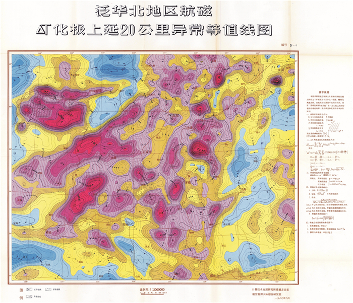
表 1 泛华北航磁资料处理印发图件
Table 1. Maps by aeromagnetic data processing in pan-North China region
编号 图名 处理方法 1 泛华北地区航磁ΔT上延20 km异常等值线图 向上延拓 2 泛华北地区航磁ΔT上延40 km异常等值线图 向上延拓 3 泛华北地区航磁ΔT化极上延10 km异常等值线图 向上延拓、化极 4 泛华北地区航磁ΔT化极上延20 km异常等值线图 向上延拓、化极 5 泛华北地区航磁ΔT化极上延40 km异常等值线图 向上延拓、化极 6 泛华北地区航磁ΔT化极上延20 km 0°方向水平异常等值线图 向上延拓、方向导数 7 泛华北地区航磁ΔT化极上延20 km 45°方向水平异常等值线图 向上延拓、方向导数 8 泛华北地区航磁ΔT化极上延20 km 90°方向水平异常等值线图 向上延拓、方向导数 9 泛华北地区航磁ΔT化极上延20 km 315°方向水平异常等值线图 向上延拓、方向导数 10 泛华北地区航磁ΔT化极上延20 km垂向导数异常等值线图 向上延拓、方向导数 11 泛华北地区航磁ΔT化极上延20 km导数模异常等值线图 向上延拓、梯度模 12 泛华北地区航磁ΔT化极上延40 km导数模异常等值线图 向上延拓、梯度模 13 泛华北地区航磁ΔT假重力异常等值线图 磁源重力异常 14 泛华北地区深部磁性块体平均深度图 功率谱法 15 泛华北地区航磁ΔT化极上延100 km异常图 向上延拓、化极 注: 表中将原图名中"公里"改为"km".  下载: 导出CSV
-
[1] 骆遥, 蔡劭琨, 吴美平, 等. 面向航空重磁测量的位场转换方法研究[M]. 北京: 国防工业出版社, 2020.
Luo Y, Cai S K, Wu M P, et al. Research on transformations of potential field data for aeromagnetic and airborne gravity survey[M]. Beijing: National Defense Industry Press, 2020.
[2] 黄汲清. 中国地质科学的主要成就(四)[J]. 中国科技史料, 1984, 5(2): 26-46.
Huang J Q. China's major achievements in geological sciences (IV)[J]. China Historical Materials of Science and Technology, 1984, 5(2): 26-46. (in Chinese)
[3] 杨光庆, 朱英. 中国地质普查勘探中的航空磁测工作[J]. 地球物理学报, 1979, 22(4): 374-382. doi: 10.3321/j.issn:0001-5733.1979.04.010
Yang G Q, Zhu Y. Aeromagnetic survey for geological reconnaissance work in China[J]. Acta Geophysica Sinica, 1979, 22(4): 374-382. doi: 10.3321/j.issn:0001-5733.1979.04.010
[4] 张用夏. 中国海洋航空物探的发展与成果[J]. 海洋地质与第四纪地质, 1989, 9(3): 9-17.
Zhang Y X. Development and achievements of China airborne geophysical survey over offshore areas[J]. Marine Geology & Quaternary Geology, 1989, 9(3): 9-17.
[5] Zhang Y X, Yang H. Aeromagnetic survey and geological structure of offshore China[J]. Science Sinica (Series B), 1983, 26(9): 996-1008.
[6] 骆遥, 段树岭, 王金龙, 等. AGS-863航磁全轴梯度勘查系统关键性指标测试[J]. 物探与化探, 2011, 35(5): 620-625.
Luo Y, Duan S L, Wang J L, et al. Key indicators testing for AGS-863 three axis airborne magnetic gradiometer[J]. Geophysical & Geochemical Exploration, 2011, 35(5): 620-625.
[7] 骆遥, 王平, 段树岭, 等. 航磁垂直梯度调整ΔT水平方法研究[J]. 地球物理学报, 2012, 55(11): 3854-3861. doi: 10.6038/j.issn.0001-5733.2012.11.033
Luo Y, Wang P, Duan S L, et al. Leveling total field aeromagnetic data with measured vertical gradient[J]. Chinese Journal of Geophysics, 2012, 55(11): 3854-3861. doi: 10.6038/j.issn.0001-5733.2012.11.033
[8] Luo Y, Wu M P, Wang P, et al. Full magnetic gradient tensor from triaxial aeromagnetic gradient measurements: Calculation and application[J]. Applied Geophysics, 2015, 12(3): 283-291. doi: 10.1007/s11770-015-0508-y
[9] Xie R K, Xiong S Q, Duan S L, et al. Noise estimation in vector magnetic data derived from airborne vector magnetic system[J]. Geophysics, 2020, 85(4): J71-J83. doi: 10.1190/geo2019-0663.1
[10] 徐祖哲. 溯源中国计算机[M]. 北京: 生活·读书·新知三联书店, 2015.
Xu Z Z. Tracing the origin of computers in China[M]. Beijing: SDX Joint Publishing Company, 2015. (in Chinese)
[11] 陈正清. 纪念图灵诞辰100周年所想到的——追忆我国第一台百万次集成电路电子计算机150(DJS11)机的诞生[J]. 计算机教育, 2012, (11): 126-129, 140.
Chen Z Q. The 100th anniversary of Turing's birth: A review of the 150 (DJS11) computer, the first millionth integrated circuit electronic computer in China[J]. Computer Education, 2012, (11): 126-129, 140. (in Chinese)
[12] 陈芳. 北京大学"200号"与特殊年代的超级工程[J]. 北京观察, 2017(9): 66-70.
Chen F. No. 200 Computer of Peking University and super projects in special times[J]. Beijing Observation, 2017(9): 66-70. (in Chinese)
[13] 电子仪器厂DJS-11机软件组. 150(DJS-11)机的软件[J]. 北京大学学报(自然科学版), 1974(S1): 144-157.
Software Group of DJS-11 Computer. Software for the 150 (DJS-11) computer[J]. Acta Scientiarum Naturalium Universitatis Pekinensis, 1974(S1): 144-157. (in Chinese)
[14] 王宏琳, 罗国安. 国产地震处理解释软件的发展[J]. 石油地球物理勘探, 2013, 48(2): 325-331.
Wang H L, Luo G A. Seismic data processing and interpretation software progress in China[J]. Oil Geophysical Prospecting, 2013, 48(2): 325-331.
[15] 王宏琳. 地震软件技术: 勘探地球物理计算机软件开发[M]. 北京: 石油工业出版社, 2005.
Wang H L. Seismic software technology: Computer software development for exploration geophysics[M]. Beijing: Petroleum Industry Press, 2005. (in Chinese)
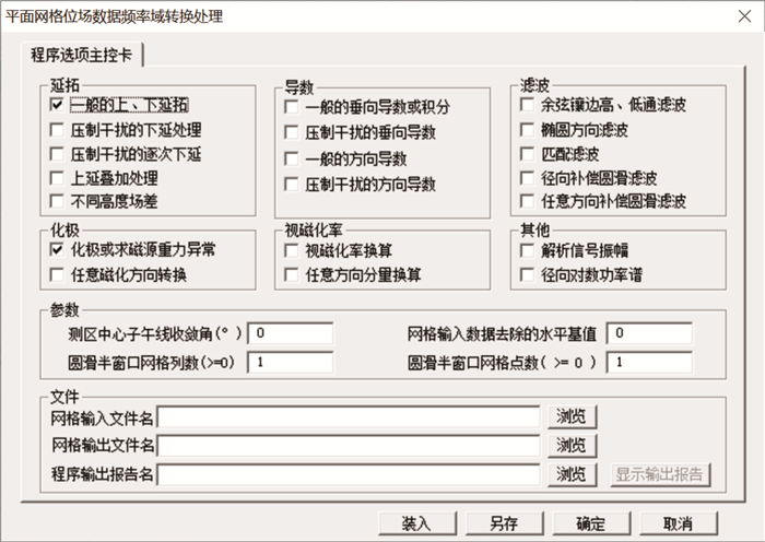
[16] 侯重初, 刘秀芳. 用二维富氏变换进行重磁位场的转换[J]. 北京师范大学学报(自然科学版), 1978, 14(2): 54-69.
Hou C C, Liu X F. Potential field transform of gravity and magnetic data by Fourier transform[J]. Journal of Beijing Normal University (Natural Science), 1978, 14(2): 54-69. (in Chinese)
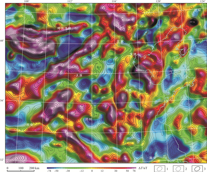
[17] 蔡宗熹. 曲面上的位场理论及其在地球物理中的应用[M]. 郑州: 河南科学技术出版社, 2002.
Cai Z X. Potential field theory on an uneven surface and its application in geophysics[M]. Zhengzhou: Henan Science & Technology Press, 2002. (in Chinese)
[18] 朱英. 中国及邻区大地构造和深部构造纲要——全国1: 100万航磁异常图的初步解释[M]. 2版. 北京: 地质出版社, 2013.
Zhu Y. Framework: Geotectonic and deep crustal architectural features of China and some peripheral areas[M]. 2nd ed. Beijing: Geological Publishing House, 2013.
[19] Arkani-Hamed J. Differential reduction-to-the-pole of regional magnetic anomalies[J]. Geophysics, 1988, 53(12): 1592-1600.
[20] Cooper G R J, Cowan D R. Differential reduction to the pole[J]. Computers & Geosciences, 2005, 31(8): 989-999.
[21] Swain C J. Reduction-to-the-pole of regional magnetic data with variable field direction, and its stabilisation at low inclinations[J]. Exploration Geophysics, 2000, 31(1/2): 78-83.
[22] Arkani-Hamed J. Differential reduction to the pole: Revisited[J]. Geophysics, 2007, 72(1): L13-L20.
[23] Luo Y, Wu M P. Vector transformation and reduction to the pole for regional magnetic data with variable field direction[J]. Applied Geophysics, 2022, 19(1): 107-116.
[24] Gunn P J. Linear transformations of gravity and magnetic fields[J]. Geophysical Prospecting, 1975, 23(2): 300-312.
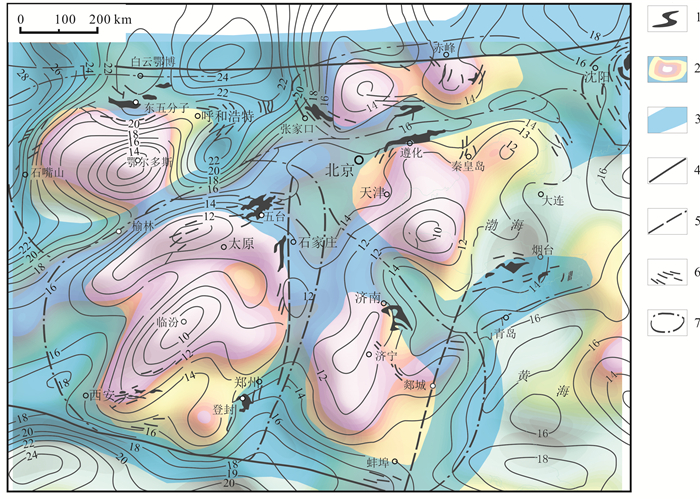
[25] 刘寿彭. 应用航磁资料研究华北地区深部构造的初步结果[J]. 物探与化探, 1981, 5(3): 129-137.
Liu S P. Preliminary results of the deep tectonics in North China by application of aeromagnetic data[J]. Geophysical & Geochemical Exploration, 1981, 5(3): 129-137. (in Chinese)
[26] 侯重初. 居里面深度图的计算与制作方法[J]. 物探化探计算技术, 1989, 11(4): 306-311.
Hou C C. Method for calculating and compiling the map of curie-point surface[J]. Computing Techniques for Geophysical and Geochemical Exploration, 1989, 11(4): 306-311.
[27] 孙中任, 赵雪娟, 段会升, 等. 华北板块与西伯利亚板块缝合带之重磁证据[J]. 地质与资源, 2020, 29(5): 461-466. http://www.dzyzy.cn/article/doi/10.13686/j.cnki.dzyzy.2020.05.008
Sun Z R, Zhao X J, Duan H S, et al. Gravity and magnetic evidences for the suture zone between North China Plate and Siberian Plate[J]. Geology and Resources, 2020, 29(5): 461-466. http://www.dzyzy.cn/article/doi/10.13686/j.cnki.dzyzy.2020.05.008
[28] 林泽付, 邓昌州, 温丹, 等. 航空磁测在黑龙江伊春地区夕卡岩型锌多金属矿的找矿应用[J]. 地质与资源, 2019, 28(2): 200-207. http://www.dzyzy.cn/article/id/8397
Lin Z F, Deng C Z, Wen D, et al. Application of aeromagnetic survey in skarn type zinc polymetallic deposit prospecting in Yichun area, Heilongjiang Province[J]. Geology and Resources, 2019, 28(2): 200-207. http://www.dzyzy.cn/article/id/8397
[29] 朱英. 华北地块的大地构造和鞍山式铁矿的分布规律——根据航空磁测结果的初步分析[J]. 物探与化探, 1979, 3(1): 3-13.
Zhu Y. Geotectonic of the North China Massif and distribution of the Anshan-type iron deposits: A preliminary analysis based on aeromagnetic survey[J]. Geophysical & Geochemical Exploration, 1979, 3(1): 3-13. (in Chinese)
[30] 任纪舜, 姜春发, 张正坤, 等. 中国大地构造及其演化——1: 400万中国大地构造图简要说明[M]. 北京: 科学出版社, 1980.
Ren J S, Jiang C F, Zhang Z K, et al. The geotectonic evolution of China[M]. Beijing: Science Press, 1980. (in Chinese)
[31] 朱英. 中朝准地台大地构造和深部构造的若干问题——再论华北地块[J]. 物探与化探, 1986, 10(4): 247-256.
Zhu Y. Some problems concerning geotectonics and deep-seated structures of the Sino-Korean Paraplatform: A further discussion on North China Massif[J]. Geophysical & Geochemical Exploration, 1986, 10(4): 247-256.
[32] 马杏垣. 中国岩石圈动力学地图集[M]. 北京: 中国地图出版社, 1989.
Ma X Y. Lithspheric dynamics atlas of China[M]. Beijing: Sinomaps Press, 1989.
[33] 车自成, 罗金海, 刘良. 中国及其邻区区域大地构造学[M]. 3版. 北京: 科学出版社, 2016.
Che Z C, Luo J H, Liu L. The regional tectonics of China and its neighbors[M]. 3rd ed. Beijing: Science Press, 2016. (in Chinese)
[34] 管志宁, 安玉林, 吴朝均. 磁性界面反演及华北地区深部构造的推断[C]//王懋基, 程家印. 勘查地球物理勘查地球化学文集(第6集): 中国东部区域地球物理研究专辑. 北京: 地质出版社, 1987: 80-101.
Guan Z N, An Y L, Wu C J. Magnetic interface inversion and deep structure inference in North China[C]//Wang M J, Cheng J Y. Contributions to the Exploration Geophysics and Geochemistry-6: Regional Geophysical Features of Eastern China. Beijing: Geological Publishing House, 1987: 80-101.
[35] 白瑾, 黄学光, 戴凤岩, 等. 中国前寒武纪地壳演化[M]. 北京: 地质出版社, 1993.
Bai J, Huang X G, Dai F Y et al. The Precambrian crust evolution of China[M]. Beijing: Geological Publishing House, 1993. (in Chinese)
[36] Zhai M G, Bian A G, Zhao T P. The amalgamation of the supercontinent of North China Craton at the end of Neo-Archaean and its breakup during Late Palaeoproterozoic and Meso-Proterozoic[J]. Science in China Series D: Earth Sciences, 2000, 43(S1): 219-232.
[37] Zhai M G, Guo J H, Liu W J. Neoarchean to Paleoproterozoic continental evolution and tectonic history of the North China Craton: A review[J]. Journal of Asian Earth Sciences, 2005, 24(5): 547-561.
[38] 翟明国. 华北克拉通的形成以及早期板块构造[J]. 地质学报, 2012, 86(9): 1335-1349.
Zhai M G. Evolution of the North China Craton and early plate tectonics[J]. Acta Geologica Sinica, 2012, 86(9): 1335-1349.
[39] 万天丰. 中国大地构造学纲要[M]. 北京: 地质出版社, 2004.
Wan T F. An outline of tectonics of China[M]. Beijing: Geological Publishing House, 2004. (in Chinese)
[40] Wan T F. The tectonics of China: Data, maps and evolution[M]. Berlin, Heidelberg: Springer-Verlag, 2012.
[41] Maus S, Barckhausen U, Berkenbosch H, et al. EMAG2: A 2-arc min resolution Earth Magnetic Anomaly Grid compiled from satellite, airborne, and marine magnetic measurements[J]. Geochemistry, Geophysics, Geosystems, 2009, 10(8): Q08005.
[42] Meyer B, Chulliat A, Saltus R. Derivation and error analysis of the earth magnetic anomaly grid at 2 arc min resolution version 3 (EMAG2v3)[J]. Geochemistry, Geophysics, Geosystems, 2017, 18(12): 4522-4537.
[43] Luo Y. A huge gap of the lithospheric magnetic field model in the Qinghai-Tibet Plateau: Comment on "Characteristics of the crustal magnetic anomaly and regional tectonics in the Qinghai-Tibet Plateau and the adjacent areas"[J]. Science China Earth Sciences, 2013, 56(9): 1623-1626.
[44] Eklundh J O. A fast computer method for matrix transposing[J]. IEEE Transactions on Computers, 1972, C-21(7): 801-803.
[45] 翟甲森. 第二代航空物探方法技术及应用研究[J]. 物探与化探, 1992, 16(5): 398-400, 344.
Zhai J S. Studies on techniques and application of the second generation aerogeophysical prospecting[J]. Geophysical & Geochemical Exploration, 1992, 16(5): 398-400, 344.
[46] 刘浩军, 薛典军, 郭志宏, 等. 航空物探软件系统研制[J]. 物探与化探, 2003, 27(2): 146-149.
Liu H J, Xue D J, Guo Z H, et al. The development of the aerogeophysical software system[J]. Geophysical & Geochemical Exploration, 2003, 27(2): 146-149.
-
图(5)
表(1)
计量
- 文章访问数: 79
- PDF下载数: 26
- 施引文献: 0