

-
摘要:
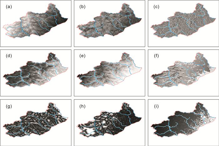
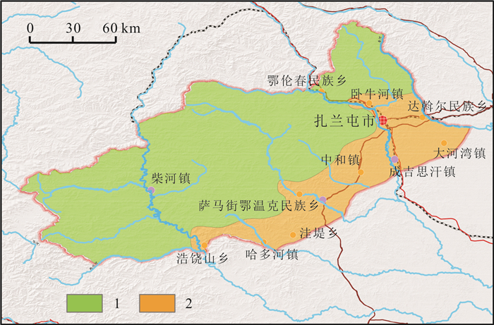
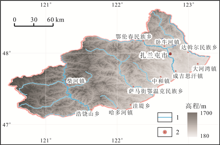
基于评价区自然资源现状, 利用Logistic回归模型和GIS技术对松嫩平原西北部扎兰屯地区土地利用进行适宜性评价. 结果表明: 影响林地分布的指标主要为土层厚度、降雨量、坡向、坡度、高程; 影响草地分布的指标主要为土层厚度、道路距离、坡向; 影响耕地分布的指标主要为坡度、土层厚度、坡向、人口密度、高程. 林地、耕地、草地AUC值分别为0.961、0.938、0.755, 拟合程度良好. 草地适宜性分区中, 高度适宜区域面积为3 375.85 km2, 占总面积的20.11%;耕地适宜性分区中, 高度适宜区域面积为3 566.36 km2, 占总面积的21.25%;林地适宜性分区中, 高度适宜区域面积为5 449.91 km2, 占总面积的32.47%.
-
关键词:
- 适宜性评价 /
- Logistic回归 /
- 土地利用 /
- 松嫩平原
Abstract:Based on the current situation of natural resources in Zhalantun area of northwestern Songnen Plain, the land use suitability in the area is evaluated with logistic regression model and GIS technology. The results show that soil thickness, rainfall, slope aspect, slope gradient and elevation are the main indexes affecting the distribution of forest land; soil thickness, distance from roads and slope aspect for the distribution grassland; while slope gradient, soil thickness, slope aspect, population density and elevation, for the distribution of cultivated land. The AUC values of forest land, cultivated land and grassland are 0.961, 0.938 and 0.755, respectively, with good fitting degree. The highly suitable area in the grassland, cultivated land and forest land suitability zoning is 3 375.85 km2, 3 566.36 km2 and 5 449.91 km2, accounting for 20.11%, 21.25%, and 32.47% of the total area, respectively.
-
Key words:
- suitability evaluation /
- logistic regression /
- land use /
- Songnen Plain
-

-
表 1 Logistic回归分析结果参数列表
Table 1. Results of logistic regression analysis
驱动力 草地 耕地 林地 回归系数 P 回归系数 P 回归系数 P 高程 0.39037 0.000*** -1.23257 0.000*** -4.24234 0.000*** 坡度 -0.90789 0.000*** -10.73192 0.000*** 4.33385 0.000*** 坡向 -2.73847 0.000*** 2.75661 0.000*** 4.69190 0.000*** 气温 -0.11240 0.000*** -0.09913 0.00010 0.38273 0.000*** 降雨量 -2.14573 0.000*** 0.34794 0.00104 6.34964 0.000*** 距水系距离 0.26423 0.000*** -0.22589 0.000*** 0.25610 0.000*** 距道路距离 -2.95071 0.000*** -0.62598 0.000*** 4.00546 0.000*** 人口密度 0.37784 0.000*** -1.75278 0.000*** -0.55465 0.000*** 土层厚度 -104.35083 0.000*** -5.08008 0.000*** -40.79570 0.000*** 注:***、**、*分别代表 1%、5%、10%的显著性水平.  下载: 导出CSV
-
[1] 王奎博, 闫敏, 张丽, 等. 基于LandUSEM模型的海南岛海岸带土地利用适宜性评价[J]. 遥感技术与应用, 2022, 37(5): 1140-1148.
Wang K B, Yan M, Zhang L, et al. Evaluation of land use suitability in the coastal zone of Hainan Island based on landUSEM[J]. Remote Sensing Technology and Application, 2022, 37(5): 1140-1148.
[2] 郑艺文, 李福杰, 刘晓煌, 等. 工业化背景下30年来中国东北地区自然资源时空变化及其生态环境效应[J]. 中国地质, 2022, 49(5): 1361-1373.
Zheng Y W, Li F J, Liu X H, et al. Temporal and spatial variation of natural resources and their ecological environment effects in Northeast China in the past 30 years under the background of industrialization[J]. Geology in China, 2022, 49(5): 1361-1373
[3] Kim H, Shim K. Land suitability assessment for apple (Malus domestica) in the Republic of Korea using integrated soil and climate information, MLCM, and AHP[J]. International Journal of Agricultural and Biological Engineering, 2018, 11(2): 139-144. doi: 10.25165/j.ijabe.20181102.2522
[4] 翟文侠, 黄贤金, 张强, 等. 基于层次分析的城市开发区土地集约利用研究——以江苏省为例[J]. 南京大学学报(自然科学版), 2006, 42(1): 96-102.
Zhai W X, Huang X J, Zhang Q, et al. Land intensive use in city development zones based on analytic hierarchy process: A case study of Jiangsu Province[J]. Journal of Nanjing University (Natural Sciences), 2006, 42(1): 96-102.
[5] Syahid L N, Sakti A D, Virtriana R, et al. Determining optimal location for mangrove planting using remote sensing and climate model projection in Southeast Asia[J]. Remote Sensing, 2020, 12(22): 3734. doi: 10.3390/rs12223734
[6] 黄巧, 彭玉玲, 秦文杰. 老挝沙湾水经济区土地利用适宜性评价[J]. 国土资源遥感, 2018, 30(4): 156-162.
Huang Q, Peng Y L, Qin W J. Research on land use suitability evaluation: A case study of Savan water economic zone in Laos[J]. Remote Sensing for Land & Resources, 2018, 30(4): 156-162.
[7] 刘韵雅, 张文秀. 四川省土地可持续利用评价——基于德尔菲法[J]. 农村经济与科技, 2014, 25(2): 14-15.
Liu Y Y, Zhang W X. Evaluation of sustainable land use in Sichuan Province: Based on the Delphi method[J]. Rural Economy and Science-Technology, 2014, 25(2): 14-15. (in Chinese)
[8] Bagheri M, Zaiton I Z, Mansor S, et al. Land-use suitability assessment using Delphi and analytical hierarchy process (D-AHP) hybrid model for coastal city management: Kuala Terengganu, Peninsular Malaysia[J]. ISPRS International Journal of Geo-Information, 2021, 10(9): 621. doi: 10.3390/ijgi10090621
[9] 陈根良. 湿地资源质量评价方法——以湖南东洞庭湖国际重要湿地为例[J]. 测绘通报, 2022(3): 28-31, 82.
Chen G L. Quality evaluation method of wetland resources: A case study the international important wetlands of East Dongting Lake in Hunan Province[J]. Bulletin of Surveying and Mapping, 2022(3): 28-31, 82.
[10] 卢东标. 基于决策树的数据挖掘算法研究与应用[D]. 武汉: 武汉理工大学, 2008.
Lu D B. Research and application on the data mining algorithm based on decision tree[D]. Wuhan: Wuhan University of Technology, 2008.
[11] Wang F. The use of artificial neural networks in a geographical information system for agricultural land-suitability assessment[J]. Environment and Planning A: Economy and Space, 1994, 26(2): 265-284. doi: 10.1068/a260265
[12] 叶云, 赵小娟, 胡月明. 基于GA-BP神经网络的珠三角耕地质量评价[J]. 生态环境学报, 2018, 27(5): 964-973.
Ye Y, Zhao X J, Hu Y M. Evaluation of cultivated land quality in Pearl River Delta based on GA-BP neural network[J]. Ecology and Environmental Sciences, 2018, 27(5): 964-973.
[13] Ding W J, Wang R Q, Wu D Q, et al. Cellular automata model as an intuitive approach to simulate complex land-use changes: An evaluation of two multi-state land-use models in the Yellow River Delta[J]. Stochastic Environmental Research and Risk Assessment, 2013, 27(4): 899-907. doi: 10.1007/s00477-012-0624-7
[14] Wang Y, Feng Z K, Ma W Y. Analysis of tree species suitability for plantation forests in Beijing (China) using an optimal random forest algorithm[J]. Forests, 2022, 13(6): 820. doi: 10.3390/f13060820
[15] Pimenta F M, Speroto A T, Costa M H, et al. Historical changes in land use and suitability for future agriculture expansion in Western Bahia, Brazil[J]. Remote Sensing, 2021, 13(6): 1088. doi: 10.3390/rs13061088
[16] 张蕾, 齐伟, 杜腾飞, 等. 基于熵权法的土地多功能利用评价——以淄博市为例[J]. 江苏农业科学, 2020, 48(3): 31-36.
Zhang L, Qi W, Du T F, et al. Multi-purpose land use evaluation based on entropy weight method: Taking Zibo City as an example[J]. Jiangsu Agricultural Sciences, 2020, 48(3): 31-36.
[17] 曹竞文, 李淑杰, 李高行, 等. 基于PSR模型和熵权法的扶余市城市土地集约利用评价[J]. 东北师大学报(自然科学版), 2019, 51(1): 125-132.
Cao J W, Li S J, Li G H, et al. Evaluation of land intensive use of Fuyu City based on PSR model and the entropy weight method[J]. Journal of Northeast Normal University (Natural Science Edition), 2019, 51(1): 125-132.
[18] 谭衢霖. 鄱阳湖湿地生态环境遥感变化监测研究[D]. 北京: 中国科学院研究生院(遥感应用研究所), 2002.
Tan Q L. Study on remote sensing change detection and its application to Poyang international importance wetland[D]. Beijing: Institute of Remote Sensing Applications, Chinese Academy of Sciences, 2002.
[19] 周立宏, 宋丽瑛, 王洪丽, 等. 扎兰屯地区近30年气象条件变化及与作物产量的关系[J]. 气象, 2006, 32(8): 113-117.
Zhou L H, Song L Y, Wang H L, et al. Relationship between crops output and changes of meteorological conditions in Zhalantun area for recent 30 years[J]. Meteorological Monthly, 2006, 32(8): 113-117.
[20] 郝世文. 扎兰屯市林业工程建设对森林资源的影响分析[J]. 内蒙古林业调查设计, 2015, 38(1): 83-85.
Hao S W. Analysis of the impact of forestry engineering construction on forest resources in Zhalantun City[J]. Inner Mongolia Forestry Investigation and Design, 2015, 38(1): 83-85. (in Chinese)
[21] 蒙吉军, 严汾, 赵春红. 大城市边缘区土地利用变化模拟研究——以北京市昌平区为例[J]. 应用基础与工程科学学报, 2010, 18(2): 197-208.
Meng J J, Yan F, Zhao C H. Land use change simulation on the edge of metropolis: A case study of Changping District in Beijing[J]. Journal of Basic Science and Engineering, 2010, 18(2): 197-208.
[22] 王海军, 孔祥冬, 张勃. 祁连山黑河山区土地适宜性评价[J]. 冰川冻土, 2016, 38(5): 1440-1446.
Wang H J, Kong X D, Zhang B. Suitability evaluation of the lands in Heihe mountainous areas in the Qilian Mountains[J]. Journal of Glaciology and Geocryology, 2016, 38(5): 1440-1446.
[23] 刘艺梁, 殷坤龙, 刘斌. 逻辑回归和人工神经网络模型在滑坡灾害空间预测中的应用[J]. 水文地质工程地质, 2010, 37(5): 92-96.
Liu Y L, Yin K L, Liu B. Application of logistic regression and artificial neural networks in spatial assessment of landslide hazards[J]. Hydrogeology and Engineering Geology, 2010, 37(5): 92-96.
[24] 易小波. 六道沟流域土地适宜性评价[D]. 杨凌: 西北农林科技大学, 2012.
Yi X B. Land suitability evaluation in Liudaogou watershed[D]. Yangling: Northwest A&F University, 2012.
[25] 张明. 土地利用结构及其驱动因子的统计分析——以榆林地区为例[J]. 地理科学进展, 1997, 16(4): 19-26.
Zhang M. A statistical analysis on land use structure and its driving forces: Taking Yulin Prefecture as an example[J]. Progress in Geography, 1997, 16(4): 19-26.
[26] 陈彭, 侯红星, 马骏驰, 等. 低山丘陵区黑土地地表基质调查研究思路——以扎兰屯地区为例[J]. 中国国土资源经济, 2023, 36(2): 81-89.
Chen P, Hou H X, Ma J C, et al. Investigation and research idea on black soil surface matrix in low mountain and hilly regions: A case study of Zalantun area[J]. Natural Resource Economics of China, 2023, 36(2): 81-89.
-


图(5)
表(1)
计量
- 文章访问数: 61
- PDF下载数: 13
- 施引文献: 0