

Application of multiple InSAR techniques and SAR data from multi-sources to landslide deformation monitoring: A case study of the Zhixincun landslide in Jilin Province
-
摘要:
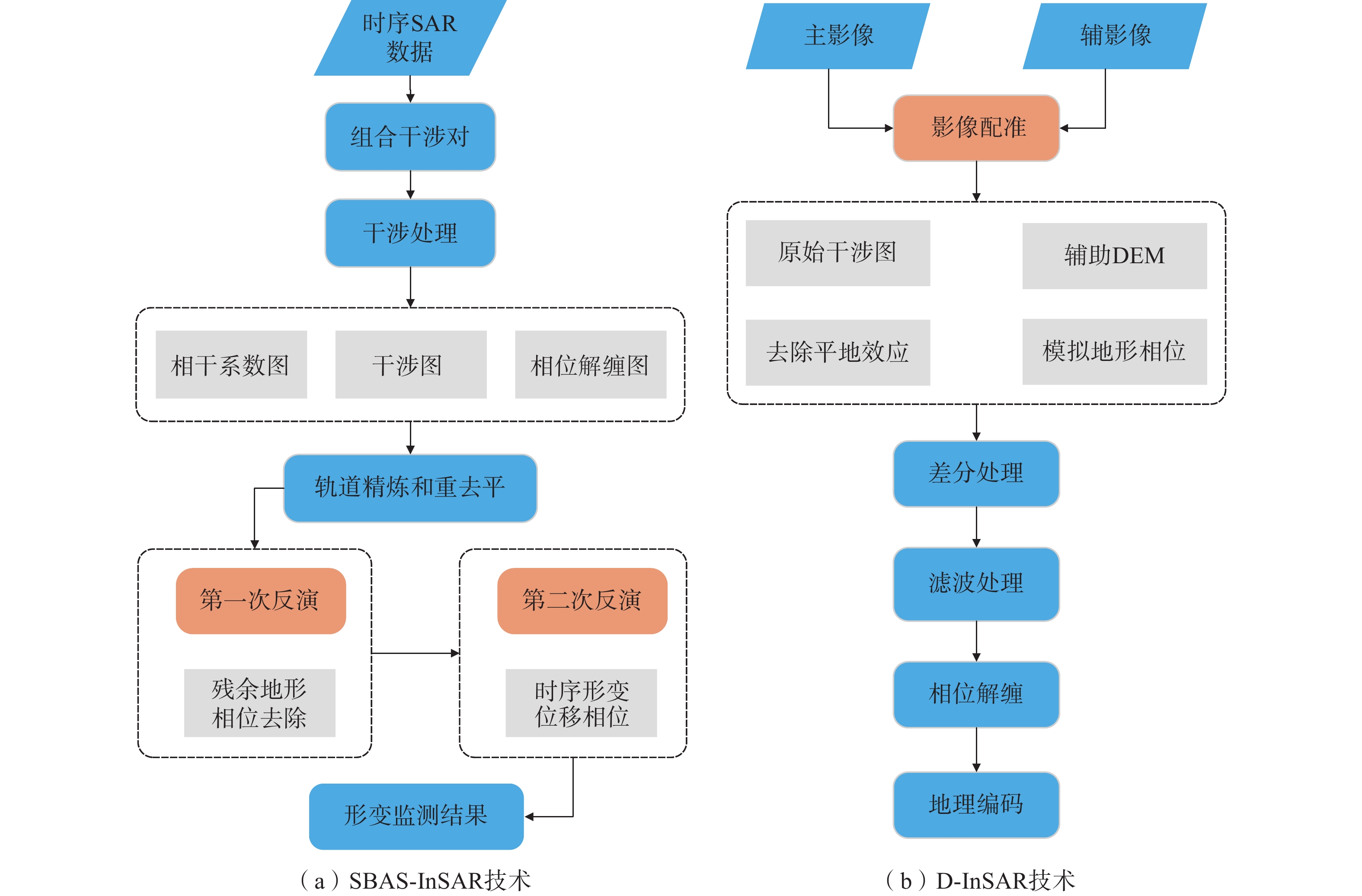
为实现对吉林省治新村滑坡的有效监测,文章选取2017年27景Sentinel-1A数据,基于小基线雷达干涉测量技术(SBAS-InSAR)对治新村滑坡进行形变监测,分析了其时序演化态势。选用2016、2017年2景ALOS-2数据,采用差分雷达干涉测量技术(D-InSAR)监测了该滑坡形变体的特征。SBAS-InSAR对滑坡形变时序演化态势进行监测,而D-InSAR则主要对滑坡具体的形变体进行形变监测,且L波段的ALOS-2数据穿透性强于C波段的Sentinel-1A数据,可以获得更完整的干涉信息,两者监测结果可交叉验证,提高结果的可靠性。SBAS-InSAR监测结果表明:治新村滑坡汇水区滑坡后缘在监测期间发生了沉降,并且在2017年7月5—29日期间滑坡后缘地表沉降达12.47 mm,监测期间平均沉降速率为2.88 mm/a;位于山谷的受威胁居民区发生了抬升,至2017年12月8日平均累计抬升达19.59 mm,监测期间平均抬升速率19.99 mm/a。D-InSAR结果显示:治新村滑坡汇水区斜坡存在5处主要变形体,面积最大变形体17973 m2,位于西侧斜坡,最不稳定变形体位于斜坡东侧,监测期间平均累计形变量最大达49.9 mm。两种监测方法都表明,滑坡灾害威胁主要来自植被覆盖较差的西侧斜坡,雨季是治新村滑坡灾害防治的重点时期。
-
关键词:
- 滑坡 /
- 治新村 /
- SBAS-InSAR /
- D-InSAR /
- ALOS-2 /
- Sentinel-1A
Abstract:In order to realize effective monitoring of Zhixincun landslide, this paper selected 27 sentinel-1A data in 2017, and conducted deformation monitoring of Zhixincun landslide based on small baseline radar interferometry technology (SBAS-InSAR), and analyzed its temporal evolution situation. Using ALOS-2 data from 2016 and 2017, differential radar interferometry (D-InSAR) was used to monitor the characteristics of the landslide variant. SBAS-InSAR monitors the temporal evolution situation of landslide deformation, while D-InSAR mainly monitors the deformation of specific landslide shape and variation. Moreover, the penetration of L-band ALOS-2 data is stronger than that of C-band sentinel-1A data, which can obtain more complete interference information. The monitoring results of both can be cross-verified. Improve the reliability of the results. The SBAS-InSAR monitoring results showed that the slope end of the landslide catchment area in Zhixincun had subsidence during the monitoring period, and the surface subsidence at the landslide end reached 12.47mm from July 5 to July 29, with an average subsidence rate of 2.88mm/a during the monitoring period. Uplift occurred in the threatened residential areas in the valley, with an average cumulative uplift of 19.59mm on December 8 and an average uplift rate of 19.99mm/a during the monitoring period. The D-InSAR results showed that there were five major deformations on the slope of Zhixincun landslide catchment area. The largest deformations with an area of 17 973m2 were located on the west side of the slope, and the most unstable deformations were located on the east side of the slope. The average cumulative shape variable reached 49.9mm during the monitoring period. Both monitoring methods showed that the threat of landslide disaster mainly came from the west slope with poor vegetation cover, and the rainy season was the key period of landslide disaster prevention and control in Zhixincun.
-
Key words:
- landslide /
- Zhixincun /
- SBAS-InSAR /
- D-InSAR /
- ALOS-2 /
- Sentinel-1A
-

-
表 1 Sentinel-1A数据集
Table 1. Sentinel-1A data set
序号 成像日期 时间基线/d 空间基线/m 01 2017-01-06 60 43.8 02 2017-01-18 48 19.9 03 2017-01-30 36 75.9 04 2017-02-11 24 170.1 05 2017-02-23 12 109.8 06 2017-03-07 0 0 07 2017-03-19 12 −15.5 08 2017-03-31 24 32.9 09 2017-04-12 36 57.4 10 2017-04-24 48 128.3 11 2017-05-06 60 92.7 12 2017-05-18 72 47.9 13 2017-05-30 84 −70.3 14 2017-06-11 96 104.5 15 2017-06-23 108 95.2 16 2017-07-05 120 25.1 17 2017-07-29 144 43.2 18 2017-08-10 156 71.3 19 2017-08-22 168 27.8 20 2017-09-03 180 62.6 21 2017-09-15 192 107.1 22 2017-09-27 204 62.3 23 2017-10-09 216 70.1 24 2017-10-21 228 122.2 25 2017-11-02 240 145.3 26 2017-11-26 264 56.1 27 2017-12-08 276 61.5  下载: 导出CSV
表 2 ALOS-2影像信息
Table 2. ALOS-2 image information
序号 成像日期 时间基线/d 空间基线/m 01 2016-07-26 392 −225.5 02 2017-08-22
下载: 导出CSV
表 3 斜坡变形体
Table 3. Deformation of slope
编号 面积/m² 最大沉降量/mm 最小沉降量/mm 平均沉降量/mm 1 5318 58.6 29.4 43.2 2 17973 50.6 24.2 36.4 3 4636 68.7 29.8 43.5 4 3043 71.8 31.3 49.9 5 11281 47.6 20.1 38.3
下载: 导出CSV
-
[1] 殷跃平,王文沛. 高位远程滑坡动力侵蚀犁切计算模型研究[J]. 岩石力学与工程学报,2020,39(8):1513 − 1521. [YIN Yueping,WANG Wenpei. Study on calculation model of dynamic erosion plowing of high-level remote landslide[J]. Chinese Journal of Rock Mechanics and Engineering,2020,39(8):1513 − 1521. (in Chinese with English abstract)
Yin Yueping, Wang Wenpei. Study on calculation model of dynamic erosion plowing of high-level remote landslide[J]. Chinese Journal of Rock Mechanics and Engineering, 2020, 39(8): 1513-1521. (in Chinese with English abstract)
[2] 黄海峰,林海玉,吕奕铭,等. 基于小型无人机遥感的单体地质灾害应急调查方法与实践[J]. 工程地质学报,2017,25(2):447 − 454. [HUANG Haifeng,LIN Haiyu,LYU Yiming,et al. Micro unmanned aerial vehicle based remote sensing method and application for emergency survey of individual geohazard[J]. Journal of Engineering Geology,2017,25(2):447 − 454. (in Chinese with English abstract)
HUANG Haifeng, LIN Haiyu, LYU Yiming, et al. Micro unmanned aerial vehicle based remote sensing method and application for emergency survey of individual geohazard[J]. Journal of Engineering Geology, 2017, 25(2): 447-454. (in Chinese with English abstract)
[3] 朱庆,曾浩炜,丁雨淋,等. 重大滑坡隐患分析方法综述[J]. 测绘学报,2019,48(12):1551 − 1561. [ZHU Qing,ZENG Haowei,DING Yulin,et al. A review of major potential landslide hazards analysis[J]. Acta Geodaetica et Cartographica Sinica,2019,48(12):1551 − 1561. (in Chinese with English abstract)
ZHU Qing, ZENG Haowei, DING Yulin, et al. A review of major potential landslide hazards analysis[J]. Acta Geodaetica et Cartographica Sinica, 2019, 48(12): 1551-1561. (in Chinese with English abstract)
[4] 张勤,黄观文,杨成生. 地质灾害监测预警中的精密空间对地观测技术[J]. 测绘学报,2017,46(10):1300 − 1307. [ZHANG Qin,HUANG Guanwen,YANG Chengsheng. Precision space observation technique for geological hazard monitoring and early warning[J]. Acta Geodaetica et Cartographica Sinica,2017,46(10):1300 − 1307. (in Chinese with English abstract) doi: 10.11947/j.AGCS.2017.20170453
ZHANG Qin, HUANG Guanwen, YANG Chengsheng. Precision space observation technique for geological hazard monitoring and early warning[J]. Acta Geodaetica et Cartographica Sinica, 2017, 46(10): 1300-1307. (in Chinese with English abstract) doi: 10.11947/j.AGCS.2017.20170453
[5] 刘文,王猛,朱赛楠,等. 基于光学遥感技术的高山极高山区高位地质灾害链式特征分析—以金沙江上游典型堵江滑坡为例[J]. 中国地质灾害与防治学报,2021,32(5):29 − 39. [LIU Wen,WANG Meng,ZHU Sainan,et al. An analysis on chain characteristics of highstand geological disasters in high mountains and extremely high mountains based on optical remote sensing technology:A case study of representative large landslides in upper reach of Jinsha River[J]. The Chinese Journal of Geological Hazard and Control,2021,32(5):29 − 39. (in Chinese with English abstract)
LIU Wen, WANG Meng, ZHU Sainan, et al. An analysis on chain characteristics of highstand geological disasters in high mountains and extremely high mountains based on optical remote sensing technology: a case study of representative large landslides in upper reach of Jinsha River[J]. The Chinese Journal of Geological Hazard and Control, 2021, 32(5): 29-39. (in Chinese with English abstract)
[6] XIE Mingli,ZHAO Weihua,JU Nengpan,et al. Landslide evolution assessment based on InSAR and real-time monitoring of a large reactivated landslide,Wenchuan,China[J]. Engineering Geology,2020,277:105781. doi: 10.1016/j.enggeo.2020.105781
[7] 王洵,周云,孙蒙,等. 青海玉树Mw6.9级地震震源破裂过程[J]. 地质通报,2014,33(4):517 − 523. [WANG Xun,ZHOU Yun,SUN Meng,et al. Rupture process of the 2010 Mw6.9 Yushu earthquake in Qinghai Province[J]. Geological Bulletin of China,2014,33(4):517 − 523. (in Chinese with English abstract)
WANG Xun, ZHOU Yun, SUN Meng, et al. Rupture process of the 2010 Mw6.9 Yushu earthquake in Qinghai Province[J]. Geological Bulletin of China, 2014, 33(4): 517-523. (in Chinese with English abstract)
[8] 刘星洪,姚鑫,周振凯,等. 滑坡灾害InSAR应急排查技术方法研究[J]. 地质力学学报,2018,24(2):229 − 237. [LIU Xinghong,YAO Xin,ZHOU Zhenkai,et al. Study of the technique for landslide rapid recognition by InSAR[J]. Journal of Geomechanics,2018,24(2):229 − 237. (in Chinese with English abstract)
LIU Xinghong, YAO Xin, ZHOU Zhenkai, et al. Study of the technique for landslide rapid recognition by insar[J]. Journal of Geomechanics, 2018, 24(2): 229-237. (in Chinese with English abstract)
[9] 张佳佳,田尤,陈龙,等. 澜沧江昌都段滑坡发育特征及形成机制[J]. 地质通报,2021,40(12):2024 − 2033. [ZHANG Jiajia,TIAN You,CHEN Long,et al. Development and formation mechanism of landslides along Changdu section of Lancang River[J]. Geological Bulletin of China,2021,40(12):2024 − 2033. (in Chinese with English abstract)
ZHANG Jiajia, TIAN You, CHEN Long, et al. Development and formation mechanism of landslides along Changdu section of Lancang River[J]. Geological Bulletin of China, 2021, 40(12): 2024-2033. (in Chinese with English abstract)
[10] 许军强,马涛,卢意恺,等. 基于SBAS-InSAR技术的豫北平原地面沉降监测[J]. 吉林大学学报(地球科学版),2019,49(4):1182 − 1191. [XU Junqiang,MA Tao,LU Yikai,et al. Land subsidence monitoring in North Henan plain based on SBAS-InSAR technology[J]. Journal of Jilin University (Earth Science Edition),2019,49(4):1182 − 1191. (in Chinese with English abstract)
XU Junqiang, MA Tao, LU Yikai, et al. Land subsidence monitoring in North Henan plain based on SBAS-InSAR technology[J]. Journal of Jilin University (Earth Science Edition), 2019, 49(4): 1182-1191. (in Chinese with English abstract)
[11] FRUNEAU B,ACHACHE J,DELACOURT C. Observation and modelling of the Saint-Étienne-de-Tinée landslide using SAR interferometry[J]. Tectonophysics,1996,265(3/4):181 − 190.
[12] MADSEN S N,ZEBKER H A,MARTIN J. Topographic mapping using radar interferometry:processing techniques[J]. IEEE Transactions on Geoscience and Remote Sensing,1993,31(1):246 − 256. doi: 10.1109/36.210464
[13] 邓云凯,禹卫东,张衡,等. 未来星载SAR技术发展趋势[J]. 雷达学报,2020,9(1):1 − 33. [DENG Yunkai,YU Weidong,ZHANG Heng,et al. Forthcoming spaceborne SAR development[J]. Journal of Radars,2020,9(1):1 − 33. (in Chinese with English abstract)
DENG Yunkai, YU Weidong, ZHANG Heng, et al. Forthcoming spaceborne SAR development[J]. Journal of Radars, 2020, 9(1): 1-33. (in Chinese with English abstract)
[14] FERRETTI A, PRATI C, ROCCA F. Permanent scatterers in SAR interferometry[C]//IEEE Transactions on Geoscience and Remote Sensing. January 2001, IEEE, 2002: 8 − 20.
[15] BERARDINO P,FORNARO G,LANARI R,et al. A new algorithm for surface deformation monitoring based on small baseline differential SAR interferograms[J]. IEEE Transactions on Geoscience and Remote Sensing,2002,40(11):2375 − 2383. doi: 10.1109/TGRS.2002.803792
[16] 姚佳明,姚鑫,陈剑,等. 基于InSAR技术的缓倾煤层开采诱发顺层岩体地表变形模式研究[J]. 水文地质工程地质,2020,47(3):135 − 146. [YAO Jiaming,YAO Xin,CHEN Jian,et al. A study of deformation mode and formation mechanism of a bedding landslide induced by mining of gently inclined coal seam based on InSAR technology[J]. Hydrogeology & Engineering Geology,2020,47(3):135 − 146. (in Chinese with English abstract) doi: 10.16030/j.cnki.issn.1000-3665.201903072
YAO Jiaming, YAO Xin, CHEN Jian, et al. A study of deformation mode and formation mechanism of a bedding landslide induced by mining of gently inclined coal seam based on InSAR technology[J]. Hydrogeology & Engineering Geology, 2020, 47(3): 135-146. (in Chinese with English abstract) doi: 10.16030/j.cnki.issn.1000-3665.201903072
[17] 赵富萌,张毅,孟兴民,等. 基于小基线集雷达干涉测量的中巴公路盖孜河谷地质灾害早期识别[J]. 水文地质工程地质,2020,47(1):142 − 152. [ZHAO Fumeng,ZHANG Yi,MENG Xingmin,et al. Early identification of geological hazards in the Gaizi valley near the Karakoran highway based on SBAS-InSAR technology[J]. Hydrogeology & Engineering Geology,2020,47(1):142 − 152. (in Chinese with English abstract)
ZHAO Fumeng, ZHANG Yi, MENG Xingmin, et al. Early identification of geological hazards in the Gaizi valley near the Karakoran Highway based on SBAS-InSAR technology[J]. Hydrogeology & Engineering Geology, 2020, 47(1): 142-152. (in Chinese with English abstract)
[18] ZHANG Y,MENG X M,DIJKSTRA T A,et al. Forecasting the magnitude of potential landslides based on InSAR techniques[J]. Remote Sensing of Environment,2020,241:111738. doi: 10.1016/j.rse.2020.111738
[19] 季灵运,王庆良,崔笃信,等. 利用SBAS-DInSAR技术提取腾冲火山区形变时间序列[J]. 大地测量与地球动力学,2011,31(4):149 − 153. [JI Lingyun,WANG Qingliang,CUI Duxin,et al. Time series of deformation in Tengchong volcanic area extracted by SBAS-DInSAR[J]. Journal of Geodesy and Geodynamics,2011,31(4):149 − 153. (in Chinese with English abstract) doi: 10.3969/j.issn.1671-5942.2011.04.034
JI Lingyun, WANG Qingliang, CUI Duxin, et al. Time series of deformation in Tengchong volcanic area extracted by sbas-dinsar[J]. Journal of Geodesy and Geodynamics, 2011, 31(4): 149-153. (in Chinese with English abstract) doi: 10.3969/j.issn.1671-5942.2011.04.034
[20] 葛伟丽,李元杰,张春明,等. 基于InSAR技术的内蒙古巴彦淖尔市地面沉降演化特征及成因分析[J]. 水文地质工程地质,2022,49(4):198 − 206. [GE Weili,LI Yuanjie,ZHANG Chunming,et al. An attribution analysis of land subsidence features in the city of Bayannur in Inner Mongolia based on InSAR[J]. Hydrogeology & Engineering Geology,2022,49(4):198 − 206. (in Chinese with English abstract)
GE Weili, LI Yuanjie, ZHANG Chunming, et al. An attribution analysis of land subsidence features in the city of Bayannur in Inner Mongolia based on InSAR[J]. Hydrogeology & Engineering Geology, 2022, 49(4): 198-206. (in Chinese with English abstract)
-


图(7)
表(3)
计量
- 文章访问数: 1305
- PDF下载数: 239
- 施引文献: 0