

Application UAV technology semi-automatic identification dangerous rock masses on ultra-high steep slopes
-
摘要:
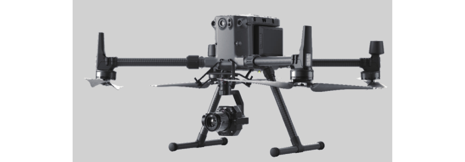
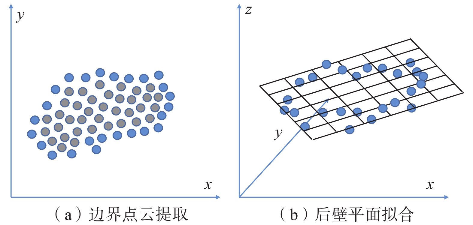
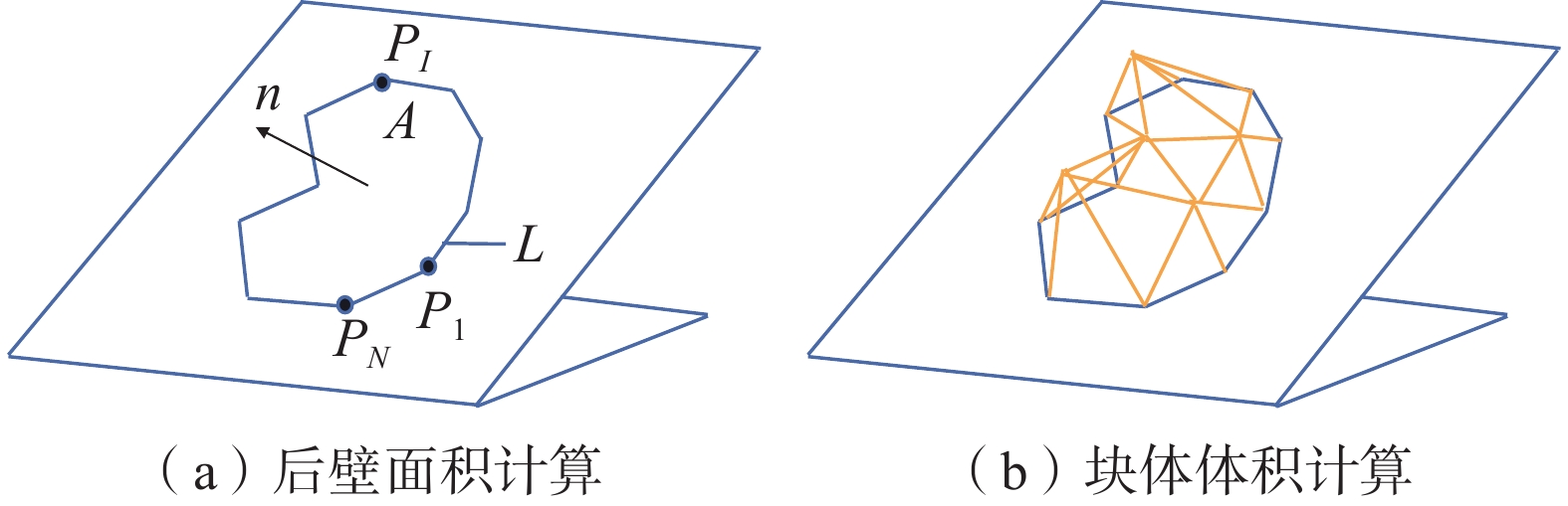
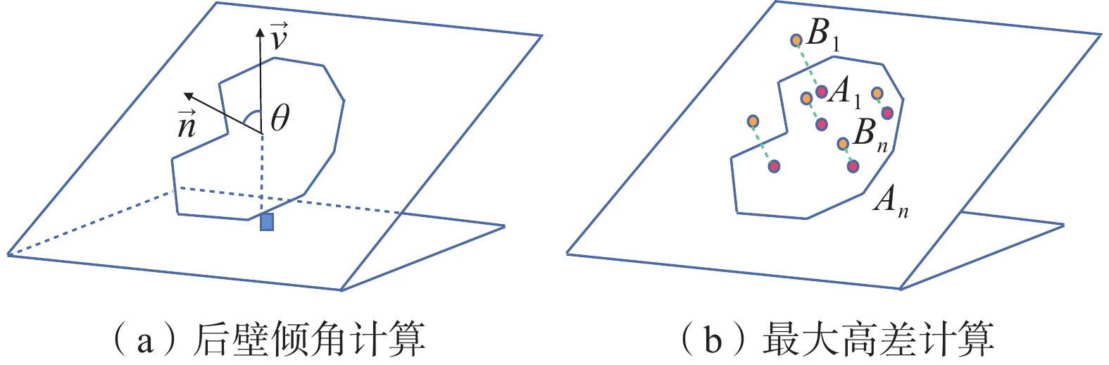
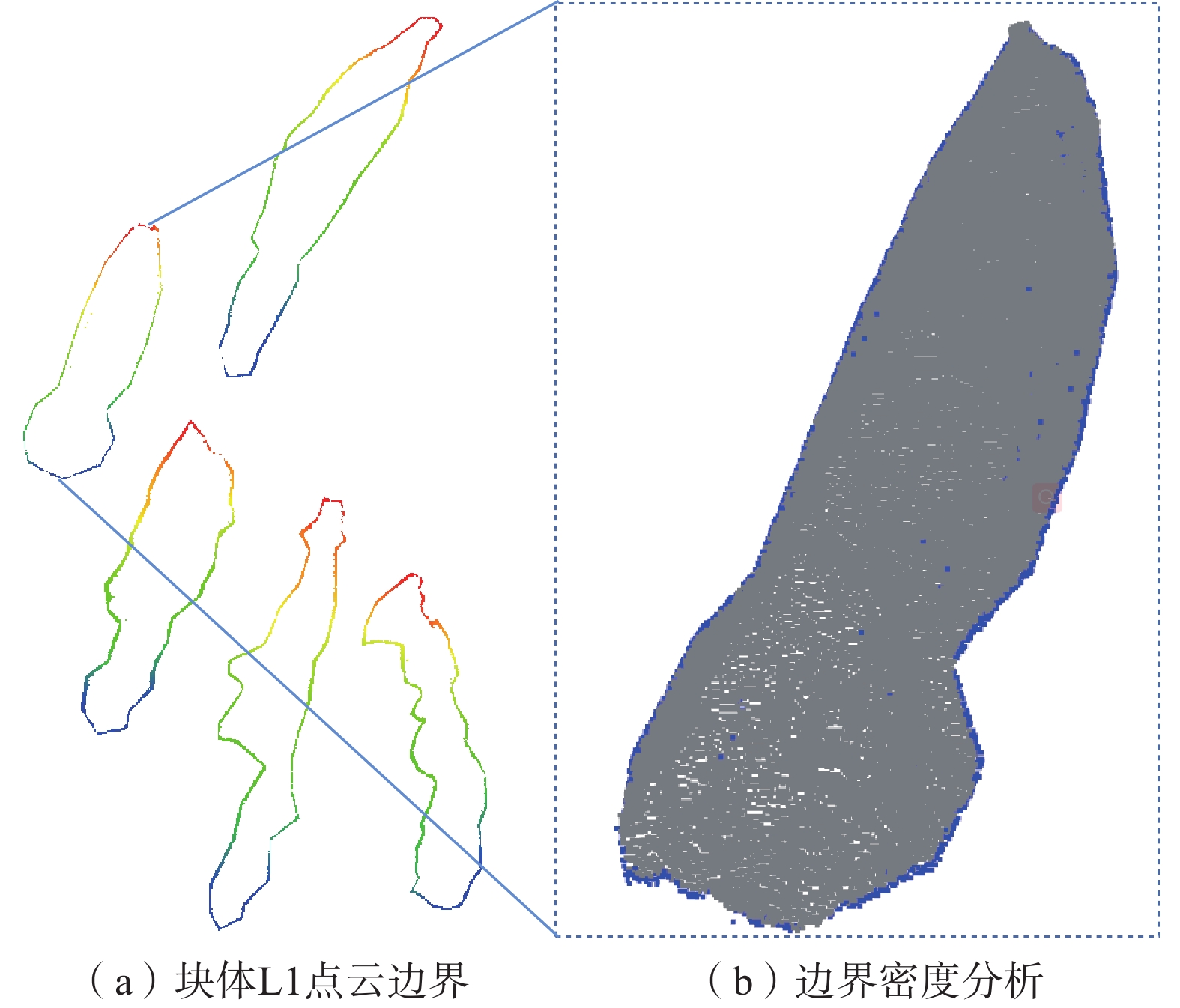
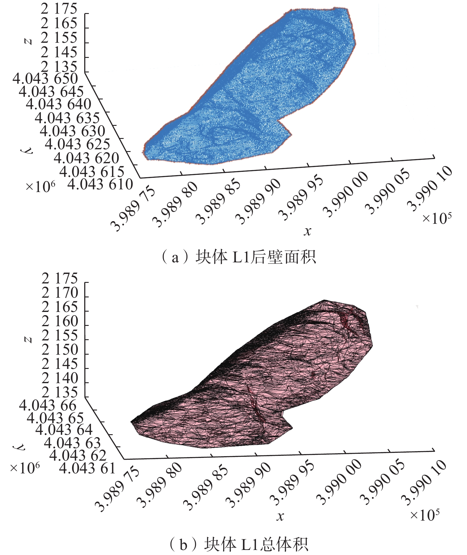
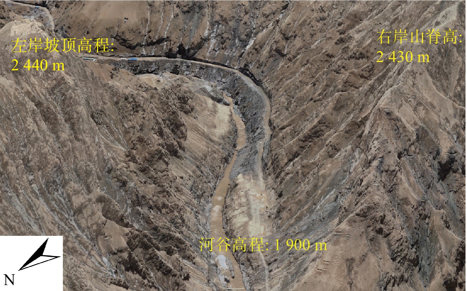
在新疆山区开展危岩体勘察时,由于工程区存在复杂且陡峭的山体,传统人工勘察危岩体的方案往往受限。为了有效地提高危岩体调查的效率与自动化程度,本研究提出了一种基于无人机的高陡边坡危岩体半自动勘察技术。将无人机贴近摄影测量技术与精确的仿地飞行路线规划相结合,获取超高边坡精确三维点云模型;应用CloudCompare软件点云剖分工具结合危岩体突出于边坡表面的形态特征对异型滑移式块体进行语义分割;并通过分析异型滑移式块体的三维特征,实现对危岩体的定性分析。将上述理论方法应用于玉龙喀什水利工程左岸超高边坡坝址,在试验区提取出了4块危岩体。所有危岩体稳定性系数(K)均低于0.9,平均体积均在2000 m3左右,最大高差在7~11 m。危岩体的空间位置分布和三维特征与现场人工勘测的基本一致。试验表明,结合危岩体特征的高精度边坡点云模型能有效识别危岩体,提高调查效率并解决人工数据模糊的问题,对高陡边坡的危岩体评估具有实际应用价值。
Abstract:In the mountainous regions of Xinjiang, traditional manual survey methods for dangerous rock masses are often restricted by the complex and steep terrain. To improve the efficiency and automation of dangerous rock masses surveys, this study proposes a semi-automatic technique using unmanned aerial vehicle (UAV) for high and steep slopes. This methodology integrates close-range photogrammetry with precise terrain-following flight path planning to generate accurate 3D point cloud models of ultra-high steep slopes. Considering the distinctive shapes of dangerous rock masses protruding from the slope surfaces, this research leveraged CloudCompare software's point cloud segmentation tool to perform semantic segmentation of these profiled blocks. Furthermore, a qualitative assessment of dangerous rock masses is achieved through an analysis of their three-dimensional features. This methodology was applied to the ultra-high slope dam site on the left bank of the Yulong Kashi Hydropower Project. In the test area, four dangerous rock masses were identified (all with stability coefficients lower than 0.9, average around 2000 m³ in volume, with height differences ranging from 7-11m), aligning closely with manual field surveys. The research shows that high-precision slope point cloud models, integrated with rock body characteristics, can effectively detect dangerous rock masses, enhance survey efficiency, and mitigate the inaccuracies associated with manual data collection. This approach holds significant practical value for assessing dangerous rock masses on ultra-high steep slopes.
-
Key words:
- unmanned aerial vehicle /
- accurate point cloud /
- profiled block /
- dangerous rock masses
-

-
表 1 单平面滑动岩体稳定性评价
Table 1. Stability evaluation of single-plane sliding rock mass
稳定性系数 稳定性分级 
稳定 
基本稳定 
欠稳定 
不稳定  下载: 导出CSV
表 2 水电工程危险岩体规模分级
Table 2. Scale classification of dangerous rock mass in hydropower projects
评价依据 小型 中型 大型 超大型 体积/m3 


 下载: 导出CSV
表 3 异形滑移式块体特征数据统计
Table 3. Statistical analysis of characteristic data for profiled blocks
块体编号 后壁倾角/(°) 后壁面积/m2 块体体积/m3 最大高差/m L1 50.35 728.15 1712.30 7.65 L2 45.58 835.53 2398.60 10.60 L3 40.42 842.94 2299.47 9.48 L4 26.23 706.89 3294.37 14.53 L5 46.61 886.78 1690.18 7.71
下载: 导出CSV
表 4 异形滑移式块体物理力学参数
Table 4. Physical and mechanical parameters of profiled block
参数 块体重度/(kN·m−3) 结构面黏聚力/MPa 结构面内摩擦角/(°) 取值 25.8 0.100 35
下载: 导出CSV
表 5 危险岩体稳定系数的计算与定性
Table 5. Calculation and qualitative characterization of stability coefficient of dangerous rock mass
块体编号 稳定性系数 稳定性分析 块体性质 L1 0.58 不稳定 是 L2 0.69 不稳定 是 L3 0.82 不稳定 是 L4 1.42 稳定 否 L5 0.66 不稳定 是
下载: 导出CSV
表 6 危险岩体与岩体体积评价
Table 6. dangerous rock mass and rock massvolume evaluation
危岩体编号 危岩体体积/m3 危岩体体积评价 L1 1712.30 大型 L2 2398.60 大型 L3 2299.47 大型 L5 1690.18 大型
下载: 导出CSV
-
[1] 黄发明, 石雨, 欧阳慰平, 等. 基于证据权和卡方自动交互检测决策树的滑坡易发性预测[J]. 土木与环境工程学报(中英文),2022,44(5):16 − 28. [HUANG Faming, SHI Yu, OUYANG Weiping, et al. Landslide susceptibility prediction modeling based on weight of evidence and Chi-square automatic interactive detection decision tree[J]. Journal of Civil and Environmental Engineering,2022,44(5):16 − 28. (in Chinese with English abstract)]
HUANG Faming, SHI Yu, OUYANG Weiping, et al . Landslide susceptibility prediction modeling based on weight of evidence and Chi-square automatic interactive detection decision tree[J]. Journal of Civil and Environmental Engineering,2022 ,44 (5 ):16 −28 . (in Chinese with English abstract)[2] 赵树兴. 基于FLAC和极限平衡法的边坡稳定性分析[J]. 市政技术,2021,39(7):35 − 39. [ZHAO Shuxing. Slope stability analysis based on FLAC and limit equilibrium method[J]. Municipal Engineering Technology,2021,39(7):35 − 39. (in Chinese with English abstract)]
ZHAO Shuxing . Slope stability analysis based on FLAC and limit equilibrium method[J]. Municipal Engineering Technology,2021 ,39 (7 ):35 −39 . (in Chinese with English abstract)[3] 傅宏易, 刘远征. 激光测距仪在MATLAB辅助下的危岩体调查应用[J]. 科技通报,2021,37(1):34 − 38. [FU Hongyi, LIU Yuanzheng. Application of laser rangefinder in dangerous rock mass survey assisted by MATLAB[J]. Bulletin of Science and Technology,2021,37(1):34 − 38. (in Chinese with English abstract)]
FU Hongyi, LIU Yuanzheng . Application of laser rangefinder in dangerous rock mass survey assisted by MATLAB[J]. Bulletin of Science and Technology,2021 ,37 (1 ):34 −38 . (in Chinese with English abstract)[4] DUAN Shuqian,FENG Xiating,JIANG Quan,et al. In situ observation of failure mechanisms controlled by rock masses with weak interlayer zones in large underground cavern excavations under high geostress[J]. Rock Mechanics and Rock Engineering,2017,50(9):2465 − 2493. doi: 10.1007/s00603-017-1249-4
[5] WANG Xueliang,FRATTINI P,STEAD D,et al. Dynamic rockfall risk analysis[J]. Engineering Geology,2020,272:105622. doi: 10.1016/j.enggeo.2020.105622
[6] 陈文宝, 王立明, 张宏伟, 等. 基于ABAQUS的边坡稳定性分析[J]. 市政技术,2017,35(4):177 − 180. [CHEN Wenbao, WANG Liming, ZHANG Hongwei, et al. Slope stability analysis based on ABAQUS[J]. Municipal Engineering Technology,2017,35(4):177 − 180. (in Chinese with English abstract)]
CHEN Wenbao, WANG Liming, ZHANG Hongwei, et al . Slope stability analysis based on ABAQUS[J]. Municipal Engineering Technology,2017 ,35 (4 ):177 −180 . (in Chinese with English abstract)[7] BITENC M,KIEFFER D S,KHOSHELHAM K. Range versus surface denoising of terrestrial laser scanning data for rock discontinuity roughness estimation[J]. Rock Mechanics and Rock Engineering,2019,52(9):3103 − 3117. doi: 10.1007/s00603-019-01755-2
[8] SALVINI R,FRANCIONI M,RICCUCCI S,et al. Photogrammetry and laser scanning for analyzing slope stability and rock fall runout along the Domodossola–Iselle railway,the Italian Alps[J]. Geomorphology,2013,185:110 − 122. doi: 10.1016/j.geomorph.2012.12.020
[9] KUMHÁLOVÁ J,KUMHÁLA F,NOVÁK P,et al. Airborne laser scanning data as a source of field topographical characteristics[J]. Plant,Soil and Environment,2013,59(9):423 − 431.
[10] 康尘云. 基于倾斜摄影的高位危岩特征获取和稳定性评价——以重庆万州观音山危岩带为例[J]. 中国地质灾害与防治学报,2022,33(5):66 − 75. [KANG Chenyun. Feature acquisition and stability evaluation of high dangerous rock mass based on oblique photography: a case study at Guanyinshan in Wanzhou, Chongqing Province[J]. The Chinese Journal of Geological Hazard and Control,2022,33(5):66 − 75. (in Chinese with English abstract)]
KANG Chenyun . Feature acquisition and stability evaluation of high dangerous rock mass based on oblique photography: a case study at Guanyinshan in Wanzhou, Chongqing Province[J]. The Chinese Journal of Geological Hazard and Control,2022 ,33 (5 ):66 −75 . (in Chinese with English abstract)[11] NIETHAMMER U,JAMES M R,ROTHMUND S,et al. UAV-based remote sensing of the Super-Sauze landslide:evaluation and results[J]. Engineering Geology,2012,128:2 − 11. doi: 10.1016/j.enggeo.2011.03.012
[12] RIQUELME A,TOMÁS R,CANO M,et al. Automatic mapping of discontinuity persistence on rock masses using 3D point clouds[J]. Rock Mechanics and Rock Engineering,2018,51(10):3005 − 3028. doi: 10.1007/s00603-018-1519-9
[13] ZEYBEK M,ŞANLıOĞLU İ. Point cloud filtering on UAV based point cloud[J]. Measurement,2019,133:99 − 111. doi: 10.1016/j.measurement.2018.10.013
[14] 赵婷婷, 高文娟, 李志林, 等. 实景三维技术在“8•8” 九寨沟地震地质灾害快速调查中的应用[J]. 中国地质灾害与防治学报,2023,34(3):93 − 99. [ZHAO Tingting, GAO Wenjuan, LI Zhilin, et al. Application of real-scene 3D technology in the rapid survey of geological disasters after the “8•8” Jiuzhaigou earthquake[J]. The Chinese Journal of Geological Hazard and Control,2023,34(3):93 − 99. (in Chinese with English abstract)]
ZHAO Tingting, GAO Wenjuan, LI Zhilin, et al . Application of real-scene 3D technology in the rapid survey of geological disasters after the “8•8” Jiuzhaigou earthquake[J]. The Chinese Journal of Geological Hazard and Control,2023 ,34 (3 ):93 −99 . (in Chinese with English abstract)[15] 梁京涛, 成余粮, 王军, 等. 基于无人机遥感技术的汶川震区典型高位泥石流动态监测——以绵竹市文家沟泥石流为例[J]. 中国地质灾害与防治学报,2013,24(3):54 − 61. [LIANG Jingtao, CHENG Yuliang, WANG Jun, et al. Monitoring of a typical high position debris flow dynamic change in Wenchuan earehquake areas with unmanned aerial vehicles case study of Wenjiagou debris flows in Mianzhu County[J]. The Chinese Journal of Geological Hazard and Control,2013,24(3):54 − 61. (in Chinese with English abstract)]
LIANG Jingtao, CHENG Yuliang, WANG Jun, et al . Monitoring of a typical high position debris flow dynamic change in Wenchuan earehquake areas with unmanned aerial vehicles case study of Wenjiagou debris flows in Mianzhu County[J]. The Chinese Journal of Geological Hazard and Control,2013 ,24 (3 ):54 −61 . (in Chinese with English abstract)[16] 黄发明, 陈佳武, 唐志鹏, 等. 不同空间分辨率和训练测试集比例下的滑坡易发性预测不确定性[J]. 岩石力学与工程学报,2021,40(6):1155 − 1169. [HUANG Faming, CHEN Jiawu, TANG Zhipeng, et al. Uncertainties of landslide susceptibility prediction due to different spatial resolutions and different proportions of training and testing datasets[J]. Chinese Journal of Rock Mechanics and Engineering,2021,40(6):1155 − 1169. (in Chinese with English abstract)]
HUANG Faming, CHEN Jiawu, TANG Zhipeng, et al . Uncertainties of landslide susceptibility prediction due to different spatial resolutions and different proportions of training and testing datasets[J]. Chinese Journal of Rock Mechanics and Engineering,2021 ,40 (6 ):1155 −1169 . (in Chinese with English abstract)[17] NICHOLSON L,MERTES J. Thickness estimation of supraglacial debris above ice cliff exposures using a high-resolution digital surface model derived from terrestrial photography[J]. Journal of Glaciology,2017,63(242):989 − 998. doi: 10.1017/jog.2017.68
[18] 王明辉, 曹熙平, 谯立家. 危岩体精细调查与崩塌过程三维场景模拟——以西南某水电站高边坡为例[J]. 中国地质灾害与防治学报,2023,34(6):86 − 96. [WANG Minghui, CAO Xiping, QIAO Lijia. Comprehensive analysis of hazardous rock mass and simulation of potential rockfall processes using 3D terrain model: a case study of the high cut slope near damsite of a hydropower station in Southern China[J]. The Chinese Journal of Geological Hazard and Control,2023,34(6):86 − 96. (in Chinese with English abstract)]
WANG Minghui, CAO Xiping, QIAO Lijia . Comprehensive analysis of hazardous rock mass and simulation of potential rockfall processes using 3D terrain model: a case study of the high cut slope near damsite of a hydropower station in Southern China[J]. The Chinese Journal of Geological Hazard and Control,2023 ,34 (6 ):86 −96 . (in Chinese with English abstract)[19] 党杰, 董吉, 何松标, 等. 机载LiDAR与地面三维激光扫描在贵州水城独家寨崩塌地质灾害风险调查中的应用[J]. 中国地质灾害与防治学报,2022,33(4):106 − 113. [DANG Jie, DONG Ji, HE Songbiao, et al. Application of airborne LiDAR and ground 3D laser scanning in geological hazard risk investigation of Dujiazhai collapse in Shuicheng, Guizhou[J]. The Chinese Journal of Geological Hazard and Control,2022,33(4):106 − 113. (in Chinese with English abstract)]
DANG Jie, DONG Ji, HE Songbiao, et al . Application of airborne LiDAR and ground 3D laser scanning in geological hazard risk investigation of Dujiazhai collapse in Shuicheng, Guizhou[J]. The Chinese Journal of Geological Hazard and Control,2022 ,33 (4 ):106 −113 . (in Chinese with English abstract)[20] RABATEL A,DELINE P,JAILLET S,et al. Rock falls in high-alpine rock walls quantified by terrestrial lidar measurements:a case study in the Mont Blanc Area[J]. Geophysical Research Letters,2008,35(10):L10502.
[21] BAR N,KOSTADINOVSKI M,TUCKER M,et al. Rapid and robust slope failure appraisal using aerial photogrammetry and 3D slope stability models[J]. International Journal of Mining Science and Technology,2020,30(5):651 − 658. doi: 10.1016/j.ijmst.2020.05.013
[22] CARA S,FIORI M,MATZUZZI C. Assessment of landscape by photogrammetry proximity uav survey technique:a case study of an abandoned mine site in the Furtei Area (Sardinia-Italy)[J]. 2013.
[23] HAVAEJ M,COGGAN J,STEAD D,et al. A combined remote sensing–numerical modelling approach to the stability analysis of delabole slate quarry,cornwall,UK[J]. Rock Mechanics and Rock Engineering,2016,49(4):1227 − 1245. doi: 10.1007/s00603-015-0805-z
[24] 杜源, 王纯, 张勤, 等. 顾及黄土滑坡灾害状态特征的实时GNSS滤波算法[J]. 武汉大学学报(信息科学版),2023,48(7):1216 − 1222. [DU Yuan, WANG Chun, ZHANG Qin, et al. Real-time GNSS filtering algorithm considering state characteristics of loess landslide hazards[J]. Geomatics and Information Science of Wuhan University,2023,48(7):1216 − 1222. (in Chinese with English abstract)]
DU Yuan, WANG Chun, ZHANG Qin, et al . Real-time GNSS filtering algorithm considering state characteristics of loess landslide hazards[J]. Geomatics and Information Science of Wuhan University,2023 ,48 (7 ):1216 −1222 . (in Chinese with English abstract)[25] ALI S,LIU Dong,FU Qiang,et al. Improving the resolution of GRACE data for spatio-temporal groundwater storage assessment[J]. Remote Sensing,2021,13(17):3513. doi: 10.3390/rs13173513
[26] YANG Boxiong,ALI F,ZHOU Bo,et al. A novel approach of efficient 3D reconstruction for real scene using unmanned aerial vehicle oblique photogrammetry with five cameras[J]. Computers and Electrical Engineering,2022,99:107804. doi: 10.1016/j.compeleceng.2022.107804
[27] INAM O,QURESHI M,LARAIB Z,et al. GPU accelerated Cartesian GRAPPA reconstruction using CUDA[J]. Journal of Magnetic Resonance,2022,337:107175. doi: 10.1016/j.jmr.2022.107175
[28] 黄发明, 殷坤龙, 蒋水华, 等. 基于聚类分析和支持向量机的滑坡易发性评价[J]. 岩石力学与工程学报,2018,37(1):156 − 167. [HUANG Faming, YIN Kunlong, JIANG Shuihua, et al. Landslide susceptibility assessment based on clustering analysis and support vector machine[J]. Chinese Journal of Rock Mechanics and Engineering,2018,37(1):156 − 167. (in Chinese with English abstract)]
HUANG Faming, YIN Kunlong, JIANG Shuihua, et al . Landslide susceptibility assessment based on clustering analysis and support vector machine[J]. Chinese Journal of Rock Mechanics and Engineering,2018 ,37 (1 ):156 −167 . (in Chinese with English abstract)[29] 武永彩. 基于LiDAR点云的电力线自适应密度聚类提取[J]. 工程勘察,2023,51(5):52 − 56. [WU Yongcai. Adaptive density clustering for extracting power line based on LiDAR point clouds[J]. Geotechnical Investigation & Surveying,2023,51(5):52 − 56. (in Chinese with English abstract)]
WU Yongcai . Adaptive density clustering for extracting power line based on LiDAR point clouds[J]. Geotechnical Investigation & Surveying,2023 ,51 (5 ):52 −56 . (in Chinese with English abstract)[30] 王道杰, 陈倍, 孙健辉. 机载LiDAR点云密度对DEM精度的影响[J]. 测绘通报,2022(5):140 − 144. [WANG Daojie, CHEN Bei, SUN Jianhui. Study on the effects of point density on DEM accuracy of airborne LiDAR[J]. Bulletin of Surveying and Mapping,2022(5):140 − 144. (in Chinese with English abstract)]
WANG Daojie, CHEN Bei, SUN Jianhui . Study on the effects of point density on DEM accuracy of airborne LiDAR[J]. Bulletin of Surveying and Mapping,2022 (5 ):140 −144 . (in Chinese with English abstract)[31] MAYR A,RUTZINGER M,BREMER M,et al. Object-based classification of terrestrial laser scanning point clouds for landslide monitoring[J]. The Photogrammetric Record,2017,32(160):377 − 397. doi: 10.1111/phor.12215
[32] GOLDMAN R N. AREA OF PLANAR POLYGONS AND VOLUME OF POLYHEDRA[J]. Graphics Gems II,1991:170 − 171.
[33] WANG Binbin,XIE Jiacheng,WANG Xuewen,et al. A new method for measuring the attitude and straightness of hydraulic support groups based on point clouds[J]. Arabian Journal for Science and Engineering,2021,46(12):11739 − 11757. doi: 10.1007/s13369-021-05689-2
[34] LATO M,KEMENY J,HARRAP R M,et al. Rock bench:establishing a common repository and standards for assessing rockmass characteristics using LiDAR and photogrammetry[J]. Computers & Geosciences,2013,50:106 − 114.
[35] WANG Luqi,YIN Yueping,HUANG Bolin,et al. Damage evolution and stability analysis of the Jianchuandong Dangerous Rock Mass in the Three Gorges Reservoir Area[J]. Engineering Geology,2020,265:105439. doi: 10.1016/j.enggeo.2019.105439
[36] WU Wenlong,LIU Xiliang,GUO Jiaqi,et al. Upper limit analysis of stability of the water-resistant rock mass of a Karst tunnel face considering the seepage force[J]. Bulletin of Engineering Geology and the Environment,2021,80(7):5813 − 5830. doi: 10.1007/s10064-021-02283-6
[37] TAO Zhigang,FAN Fangzheng,YANG Xiaojie,et al. Prediction of deep rock mass quality and spatial distribution law of open-pit gold mine based on 3D geological modeling[J]. Geotechnical and Geological Engineering,2021,39(4):3221 − 3238. doi: 10.1007/s10706-021-01690-6
-


图(18)
表(6)
计量
- 文章访问数: 1855
- PDF下载数: 88
- 施引文献: 0