

TOPOGRAPHIC FEATURES OF THE SEAMOUNTS IN THECENTRAL BASIN OF THE SOUTH CHINA SEA:BASED ON MULTI-BEAM BATHYMETRIC DATA
-
摘要:
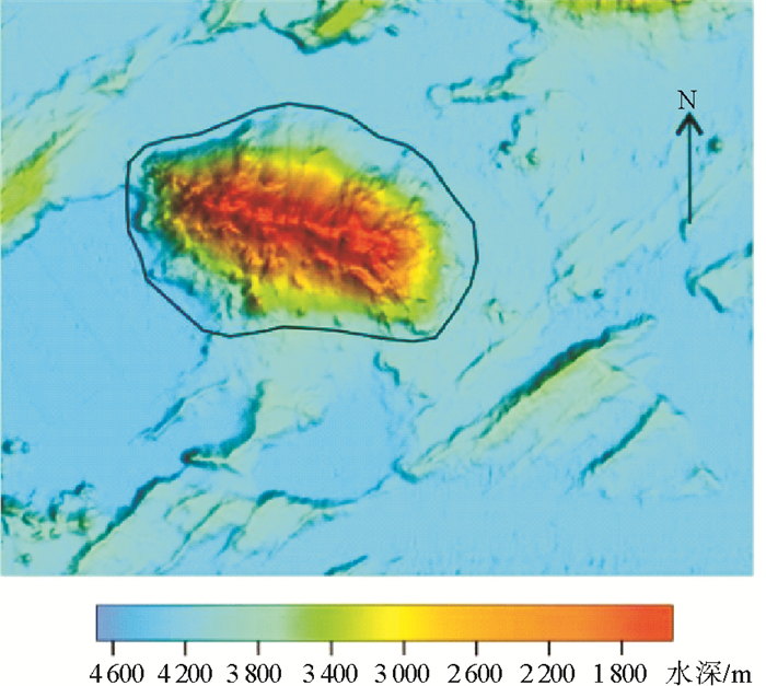
利用全覆盖的多波束数据,聚集南海海盆洋壳区,统计分析了海山的地形特征,并展示了典型海山和海丘的地形。统计结果表明,研究区发育高差1 000 m以上的海山约46个,高差1 000~500 m的海丘约90个, 高差500~200 m的海丘约100个。多波束数据揭示了海山和海丘更加精细的形态特征,如部分海山和海丘顶部保留的火山口形态。同时,发现研究区众多海山和海丘一侧山坡为陡峭的断面,推测为一系列的小断裂切割形成。基于海山和海丘的地形断面分布特征探讨了中南断裂的位置,推测中南断裂可能是由两组南北向平行的断裂及中间区域组成的断裂带。
Abstract:Upon the multi-beam bathymetric survey of the central basin of the SCS (South China Sea) in the past decades, submarine topography of the basin has become clearer. This paper is devoted to the study of the topographic features of seamounts and knolls in SCS central basin based on the multi-beam bathymetric data from Guangzhou Marine Geological Survey. Three dimensional topographic maps of typical seamounts and knolls are exhibited to reveal how the seamounts and knolls in SCS central basin look like. Statistics suggest that there are about 46 seamounts, 90 knolls with height difference in 1000-500m and about 100 knolls with height difference in 500-200m in the SCS central basin. Multi-beam bathymetric data shows finer terrain information than ever before. For examples, volcanic vents on the top of seamounts and knolls are discovered and steep slopes observed on some seamounts and knolls, probably caused by faults. Based on the distribution pattern of steep slopes, we inferred that the Zhongnan fault is actually a fault zone, consisting of two parallel N-S faults and the region between them.
-
Key words:
- seamounts /
- knolls /
- topographic features /
- Zhongnan fault /
- the central basin of South China Sea
-

-
表 1 研究区海山基本地形参数
Table 1. Topographic parameters of seamounts in the study area
序号 名称 位置 山顶
水深/m基座
水深/m高差
/m投影
面积/km 2平面形态 走向 1 中南海山 13°58.0′N,115°25.7′E 299 4379 4080 1809 近圆形 —— 2 珍贝海山 15°04.0′N,116°32.5′E 317 4371 4054 2738 线状 NW 3 龙南海山 13°21.8′N,114°58.5′E 528 4467 3939 1019 线状 NWW 4 宪北海山 16°36.8′N,116°42.4′E 210 4120 3911 1628 线状 W-E 5 黄岩西海山 15°08.5′N, 117°09.6′E 498 4385 3887 1480 线状 NW 6 龙北海山 14°00.0′N,114°52.3′E 567 4337 3769 969 圆形 —— 7 涨中海山 15°34.1′N,116°11.1′E 654 4288 3633 1131 线状 NW 8 南岳海山 13°42.1′N,115°17.8′E 868 4386 3518 910 线状 NE 9 管事平顶海山 17°12.2′N,118°45.4′E 460 4250 3540 2119 线状 NE 10 北岳海山 14°21.8′N,115°24.1′E 862 4300 3438 907 线状 W-E 11 黄岩东海山 15°17.1′N,118°17.0′E 916 4267 3350 2387 线状 NW 12 贝壳海山 15°29.2′N,118°36.8′E 1230 4500 3270 7009 线状 NE 13 钱乙海山 16°46.4′N,118°36.0′E 1153 4200 3047 3110 线状 NE 14 石星海山 16°24.8′N,116°15.6′E 1 376 4 166 2 790 1 054 线状 近E-W 15 宪南海山 15°54.5′N,116°46.9′E 1 526 4 200 2 674 897 线状 NNW 16 张仲景海山 15°50.8′N,117°30.9′E 1 819 4 254 2 435 1 161 线状 NEE 17 玳瑁海山 17°37.0′N,117°05.6′E 1 680 3 950 2 270 338 圆形 —— 18 钻石海山 15°01.4′N,114°54.5′E 2 236 4 288 2 052 310 线状 W-E 19 吴有性海山 16°50.3′N,119°00.6′E 2 200 4 200 2 000 784 线状 NW 20 玛瑙海山 12°09.4′N,115°53.8′E 2 514 4 406 1 892 899 线状 海山走向为NE, 被S-N向断裂切断 21 易安海山 14°48.0′N,115°40.0′E 2 579 4 337 1 758 787 线状 海山走向为NE, 被NW向断裂切断 22 一行海山 16°58.6′N,116°13.9′E 2 306 4 042 1 736 171 近圆形 —— 23 孙思邈海山 16°28.7′N,118°51.1′E 2 836 4 500 1 664 2 353 线状 NE 24 红宝石海山 14°40.8′N,114°30.6′E 2 663 4 321 1 658 233 线状 NW 25 蓝宝石海山 14°50.1′N,114°15.8′E 2 777 4 321 1 544 322 线状 NW 26 李时珍海山 15°53.0′N,118°19.3′E 2 968 4 500 1 532 1 396 线状 NE 27 紫贝海山 15°08.6′N, 117°24.6′E 1 065 2 596 1 531 487 线状 NW 28 管事西海山 17°16.2′N,118°28.6′E 2 515 4 032 1 516 191 线状 NE 29 龙珠海山 13°08.3′N,114°29.2′E 2 963 4 471 1 508 215 线状 W-E 30 龙门海山 12°32.3′N,113°43.3′E 2 971 4 436 1 464 318 线状 NNW 31 陆游海山 13°47.7′N,115°47.9′E 2 947 4 397 1 450 581 线状 海山走向为NE, 被NW向断裂切断 32 韩愈海山 14°04.2′N,118°21.6′E 2 802 4 249 1 447 1 516 线状 海山走向为E-W, 被S-N向和NW向两组断裂切断 33 张先海山 15°16.0′N,115°57.2′E 2 875 4 316 1 441 297 线状 NW 34 克庄海山 15°16.0′N,116°11.7′E 2 886 4 300 1 414 199 线状 NW 35 双峰海山 18°17.4′N,115°04.9′E 2 383 3 730 1 347 184 线状 NEE 36 小珍珠海山 12°41.7′N,115°58.2′E 3 046 4 390 1 344 757 线状 海山走向为NE, 被S-N向断裂切断 37 大珍珠海山 12°48.6′N,116°34.0′E 3 044 4 353 1 309 2 017 不规则 —— 38 米芾海山 13°57.3′N,115°48.4′E 3 095 4 350 1 255 727 线状 NW 39 贺铸海山 13°12.6′N,116°02.0′E 3 147 4 390 1 243 210 线状 NE 40 秦观海山 14°03.0′N,115°46.1′E 3 116 4 318 1 202 768 线状 海山走向为NE, 被S-N向断裂切断 41 华佗海山 16°31.6′N,118°03.1′E 3 045 4 241 1 196 1 746 线状 NW 42 范仲淹海山 13°25.2′N,115°46.3′E 3 165 4 360 1 195 559 线状 NE 43 王祯海山 18°09.5′N,115°49.5′E 2 635 3 823 1 188 59 近圆形 —— 44 玉佩海山 12°04.4′N,112°33.7′E 3 136 4 321 1 185 432 线状 NW 45 白居易海山 13°57.7′N,118°42.4′E 2 906 3 980 1 074 291 线状 NE 46 柳宗元海山 14°37.6′N,117°59.4′E 3 261 4 314 1 053 1 098 线状 海山走向为E-W, 被S-N向断裂切断 注:由于海丘数量多,此表只列出海山的地形参数  下载: 导出CSV
-
[1] 曾成开, 王小波.南海海盆中的海山海丘及其成因[J].东海海洋, 1987, 5(1-2): 1-9. http://www.cnki.com.cn/Article/CJFDTotal-DHHY1987Z1002.htm
ZENG Chengkai, WANG Xiaobo. Distribution and genesis of the seamounts and hills in the South China Sea[J]. Donghai Marine Science, 1987, 5(1-2): 1-9. http://www.cnki.com.cn/Article/CJFDTotal-DHHY1987Z1002.htm
[2] 鲍才旺, 薛万俊.南海深海平原海山、海丘分布规律及形成环境[J].海洋学报, 1993, 15(6): 83-90. http://www.cnki.com.cn/Article/CJFDTotal-SEAC199306009.htm
BAO Caiwang, XUE Wanjun. Distribution and formation environment of seamounts and knolls in the abysmal plain of the South China Sea[J]. Acta Oceanologica Sinica, 1993, 15(6): 83-90. http://www.cnki.com.cn/Article/CJFDTotal-SEAC199306009.htm
[3] Taylor B, Hayes D E. Origin and history of the South China Sea Basin[M]//Hayes D E. The Tectonic and Geologic Evolution of Southeast Asian Seas and Islands: Part 2. Washington, DC: American Geophysical Union, 1983: 23-56.
[4] Franke I, Savva D, Pubellier M, et al. The final rifting evolution in the South China Sea[J]. Marine and Petroleum Geology, 2014, 58: 704-720. doi: 10.1016/j.marpetgeo.2013.11.020
[5] Clift P, Lin J, Barckhausen U. Evidence of low flexural rigidity and low viscosity lower continental crust during continental break-up in the South China Sea[J]. Marine and Petroleum Geology, 2002, 19(8): 951-970. doi: 10.1016/S0264-8172(02)00108-3
[6] 李家彪.南海大陆边缘动力学:科学实验与研究进展[J].地球物理学报, 2011, 54(12): 2993-3003. doi: 10.3969/j.issn.0001-5733.2011.12.002
LI Jiabiao. Dynamics of the continental margins of South China Sea: scientific experiments and research progresses[J]. Chinese Journal of Geophysics, 2011, 54(12): 2993-3003. doi: 10.3969/j.issn.0001-5733.2011.12.002
[7] Briais A, Patriat P, Tapponnier P. Updated interpretation of magnetic anomalies and seafloor spreading stages in the South China Sea: implications for the tertiary tectonics of Southeast Asia[J]. Journal of Geophysical Research, 1993, 98(B4): 6299-6328. doi: 10.1029/92JB02280
[8] 姚伯初.中美合作调研南海地质专报[M].武汉:中国地质大学出版社, 1994.
YAO Bochu. The Geological Memoir of South China Sea Surveyed Jointly by China & USA[M]. Wuhan: China University of Geoscience Press, 1994.
[9] Hsu S K, Yeh Y C, Doo W B, et al. New bathymetry and magnetic lineations identifications in the northernmost South China Sea and their tectonic implications[J]. Marine Geophysical Researches, 2004, 25(1-2): 29-44. doi: 10.1007/s11001-005-0731-7
[10] Li C F, Song T R. Magnetic recording of the Cenozoic oceanic crustal accretion and evolution of the South China Sea Basin[J]. Chinese Science Bulletin, 2012, 57(14): 3165-3181. http://www.wanfangdata.com.cn/details/detail.do?_type=perio&id=QK201203512616
[11] Barckhausen U, Engels M, Franke D, et al. Evolution of the South China Sea: revised ages for breakup and seafloor spreading[J]. Marine and Petroleum Geology, 2014, 58: 599-611. doi: 10.1016/j.marpetgeo.2014.02.022
[12] Li C F, Xu X, Lin J, et al. Ages and magnetic structures of the South China Sea constrained by deep tow magnetic surveys and IODP Expedition 349[J]. Geochemistry, Geophysics, Geosystems, 2014, 15(12): 4958-4983. doi: 10.1002/2014GC005567
[13] Koppers A A P. On the 40Ar/39Ar dating of low-potassium ocean crust basalt from IODP Expedition 349, South China Sea[C]//Proceedings of 2014 AGU Fall Meeting. San Francisco: AGU, 2014.
http://adsabs.harvard.edu/abs/2014AGUFM.T31E..03K [14] 杨胜雄, 邱燕, 朱本铎, 等.南海地质地球物理图系(1:200万)[M].天津:中国航海图书出版社, 2015.
YANG Shengxiong, QIU Yan, ZHU Benduo, et al. Atlas of Geology and Geophysics of the South China Sea (1:2000000)[M]. Tianjin: China Navigation Publication Press, 2015.
[15] 王贤觉, 吴明清, 梁德华, 等.南海玄武岩的某些地球化学特征[J].地球化学, 1984(4): 332-340. doi: 10.3321/j.issn:0379-1726.1984.04.005
WANG Xianjue, WU Mingqing, LIANG Dehua, et al. Some geochemical characteristics of basalts in the South China Sea[J]. Geochimica, 1984(4): 332-340. doi: 10.3321/j.issn:0379-1726.1984.04.005
[16] Tu K, Flower M F J, Carlson R W, et al. Magmatism in the South China Basin: 1. Isotopic and trace-element evidence for an endogenous Dupal mantle component[J]. Chemical Geology, 1992, 97(1-2): 47-63. https://www.sciencedirect.com/science/article/abs/pii/000925419290135R
[17] 鄢全树, 石学法.海南地幔柱与南海形成演化[J].高校地质学报, 2007, 13(2): 311-322. doi: 10.3969/j.issn.1006-7493.2007.02.014
YAN Quanshu, SHI Xuefa. Hainan mantle plume and the formation and evolution of the South China Sea[J]. Geological Journal of China Universities, 2007, 13(2): 311-322. doi: 10.3969/j.issn.1006-7493.2007.02.014
[18] 鄢全树, 石学法, 王昆山, 等.南海新生代碱性玄武岩主量、微量元素及Sr-Nd-Pb同位素研究[J].中国科学D辑:地球科学, 2008, 38(1): 56-71. http://www.wanfangdata.com.cn/details/detail.do?_type=perio&id=zgkx-cd200801006
YAN Quanshu, SHI Xuefa, WANG Kunshan, et al. Major element, trace element, and Sr, Nd and Pb isotope studies of Cenozoic basalts from the South China Sea[J]. Science in China Series D: Earth Sciences, 2008, 51(4): 550-566. http://www.wanfangdata.com.cn/details/detail.do?_type=perio&id=zgkx-cd200801006
[19] Yan Q S, Shi X F, Yang Y M, et al. Potassium-argon/argon-40-argon-39 geochronology of Cenozoic alkali basalts from the South China Sea[J]. Acta Oceanologica Sinica, 2008, 27(6): 115-123. http://www.wanfangdata.com.cn/details/detail.do?_type=perio&id=hyxb-e200806011
[20] 王叶剑, 韩喜球, 罗照华, 等.晚中新世南海珍贝-黄岩海山岩浆活动及其演化:岩石地球化学和年代学证据[J].海洋学报, 2009, 31(4): 93-102. http://d.old.wanfangdata.com.cn/Periodical/hyxb200904011
WANG Yejian, HAN Xiqiu, LUO Zhaohua, et al. Late Miocene magmatism and evolution of Zhenbei-Huangyan Seamount in the South China Sea: evidence from petrochemistry and chronology[J]. Acta Oceanologica Sinica, 2009, 31(4): 93-102. http://d.old.wanfangdata.com.cn/Periodical/hyxb200904011
[21] Lebedev S, Nolet G. Upper mantle beneath southeast Asia from S velocity tomography[J]. Journal of Geophysical Research, 2003, 108(B1): 2048. http://d.old.wanfangdata.com.cn/NSTLQK/NSTL_QKJJ0212209417/
[22] Montelli R, Nolet G, Dahlen F A, et al. Finite-frequency tomography reveals a variety of plumes in the mantle[J]. Science, 2004, 303(5656): 338-343. doi: 10.1126/science.1092485
[23] Zhao D P. Seismic images under 60 hotspots: search for mantle plumes[J]. Gondwana Research, 2007, 12(4): 335-355. doi: 10.1016/j.gr.2007.03.001
[24] Lei J S, Zhao D P, Steinberger B, et al. New seismic constraints on the upper mantle structure of the Hainan plume[J]. Physics of the Earth and Planetary Interiors, 2009, 173(1-2): 33-50. doi: 10.1016/j.pepi.2008.10.013
[25] 石学法, 鄢全树.南海新生代岩浆活动的地球化学特征及其构造意义[J].海洋地质与第四纪地质, 2011, 31(2): 59-72. http://www.cnki.com.cn/Article/CJFDTotal-HYDZ201102011.htm
SHI Xuefa, YAN Quanshu. Geochemistry of Cenozoic magmatism in the South China Sea and its tectonic implications[J]. Marine Geology & Quaternary Geology, 2011, 31(2): 59-72. http://www.cnki.com.cn/Article/CJFDTotal-HYDZ201102011.htm
[26] IHO. Standardization of Undersea Feature Names[R]. Bathymetric Publication No.6. Monaco: International Hydrographic Bureau, 2008.
http://en.cnki.com.cn/Article_en/CJFDTotal-SHDX201405009.htm -


图(7)
表(1)
计量
- 文章访问数: 2130
- PDF下载数: 124
- 施引文献: 0