

-
摘要:
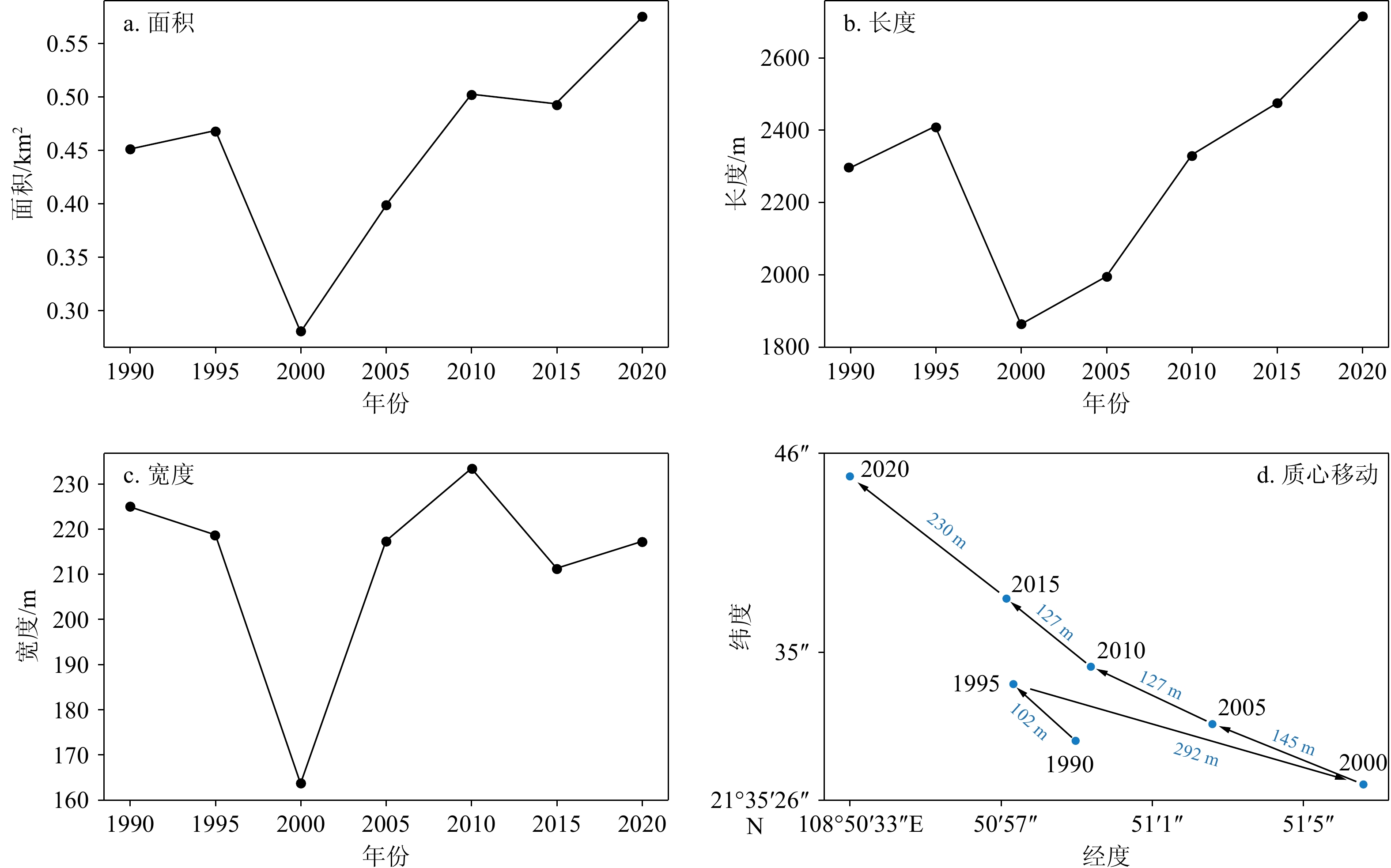
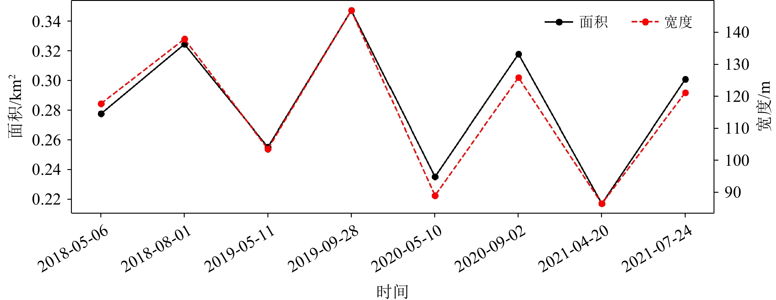
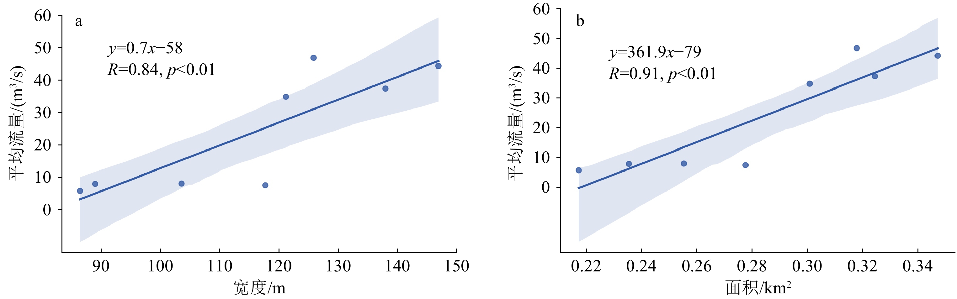
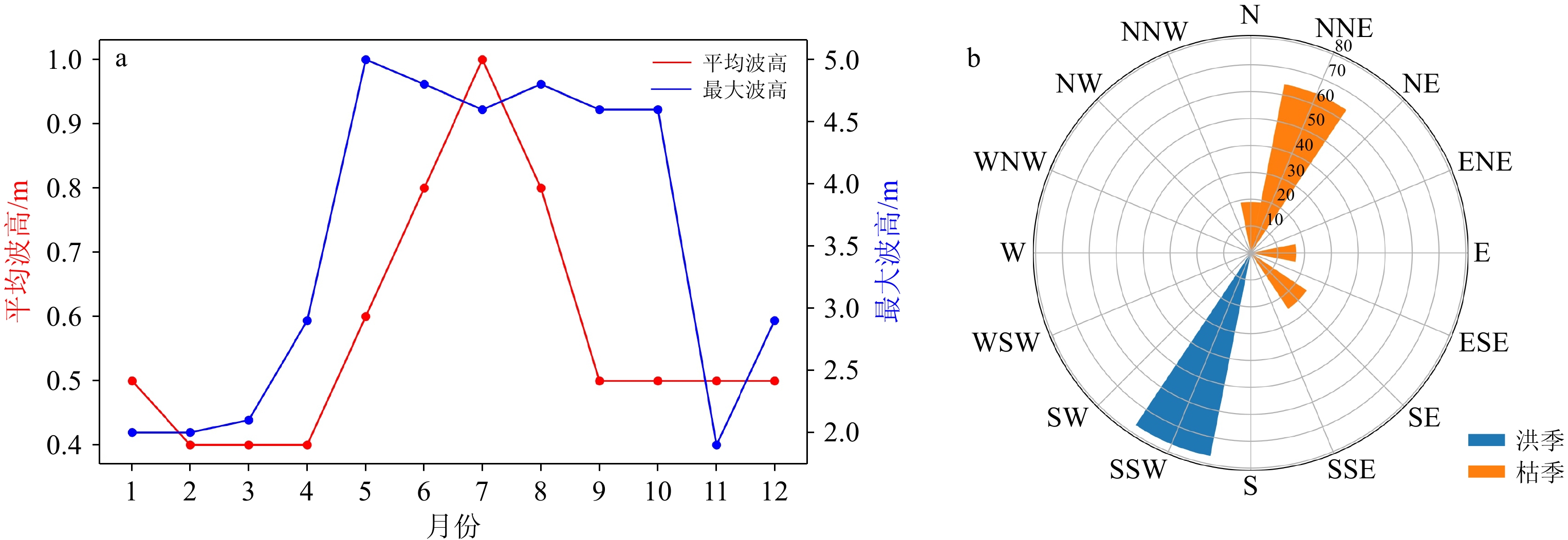
沙嘴的快速变化过程直接关联河口地貌变迁,影响陆海交汇带水沙交换,因而沙嘴地貌的移动及驱动机制成为河口研究重点关注的内容之一。然而,受限于监测资料获取的困难,一直有较少工作涉及中—强潮河口沙嘴动力地貌演变。以北部湾大风江河口沙嘴为研究对象,基于1990—2021年卫星遥感影像、2022年11月实地采集的沙嘴表层沉积物以及区域水文资料,分析中—强潮环境的大风江河口沙嘴演变特征及变化过程。结果表明:①大风江河口沙嘴持续向西北延伸,其中沙嘴宽度与面积呈洪季变大、枯季变小的季相变化特征;②沙嘴沉积物主要来源为洪季的径流来沙,沙嘴海侧顶部沉积物平均粒径最粗,并向陆侧与中部、尾部逐渐变细。沉积物主要由海侧顶部向沙嘴中部及尾部方向输移,使沙嘴持续向西北延伸。③波浪是控制大风江沙嘴长期形态演变的主要因素,中—强潮环境下潮流作用是沉积物向岸输送、沙嘴持续向西北延伸的原因,径流量的洪枯季显著差异是沙嘴宽度与面积洪季变大、枯季变小的主控因素。
Abstract:The rapid change process of sand spit is directly related to the estuarine geomorphological migration with potential impacts on water and sediment exchange between land and sea. The movement and the driving mechanism of sand spit landform have received especial concerns. However, limited information is related to sand spit morphodynamics due to difficulties in obtaining monitoring data. Based on multi-satellite remote sensing images from 1990 to 2023, surface sediments collected in November 2022, and regional hydrological data, the evolution of the sand spit in Dafeng River estuary in Beibu Gulf, Guangxi, SW China over a medium-strong tidal environment were analyzed. Results show that ① the sand spit in the estuary exhibited continuous extension to the northwest, and the width and area of the spit featured seasonal variation with increased width in flood season and decreases in dry season; ② The main sediment source of the sand spit was from riverine material in flood season. The average grain size of sediments on top the spit seaside was the coarsest and then gradually became finer from sea to land, and to the middle and tail parts of the spit. The sediments were transported mainly from the top of the sediments seaside towards the middle and tail of the spit, so that the spit continued to extend northwestward; ③ Runoff from sand is the source of sediment in the spit, waves are the main factor controlling the long-term morphological evolution of the sand spit in the estuary. Tidal actions in mild-strong tidal environment are the driver to the sediment transport shoreward and the continuous northwestward extension of the sand spit. The significant difference in seasonal runoff was the main factor on the variations in width and area of the sand spit: greater in flood season and smaller in dry season.
-
Key words:
- sediment /
- remote sensing images /
- sand spit /
- Dafeng River estuary /
- Beibu Gulf
-

-
表 1 粒径分级标准
Table 1. Grain size classification standards
等级 等级 平均粒径/µm 砾石 细砾石 8 000~4 000 砂 粗砂 2 000~500 中砂 500~250 细砂 250~62.5 粉砂 粗粉砂 62.5~16 细粉砂 16~3.9 黏土 黏土 3.9~0.24  下载: 导出CSV
表 2 沙嘴沉积物组分
Table 2. Sediment size composition of the sand spit
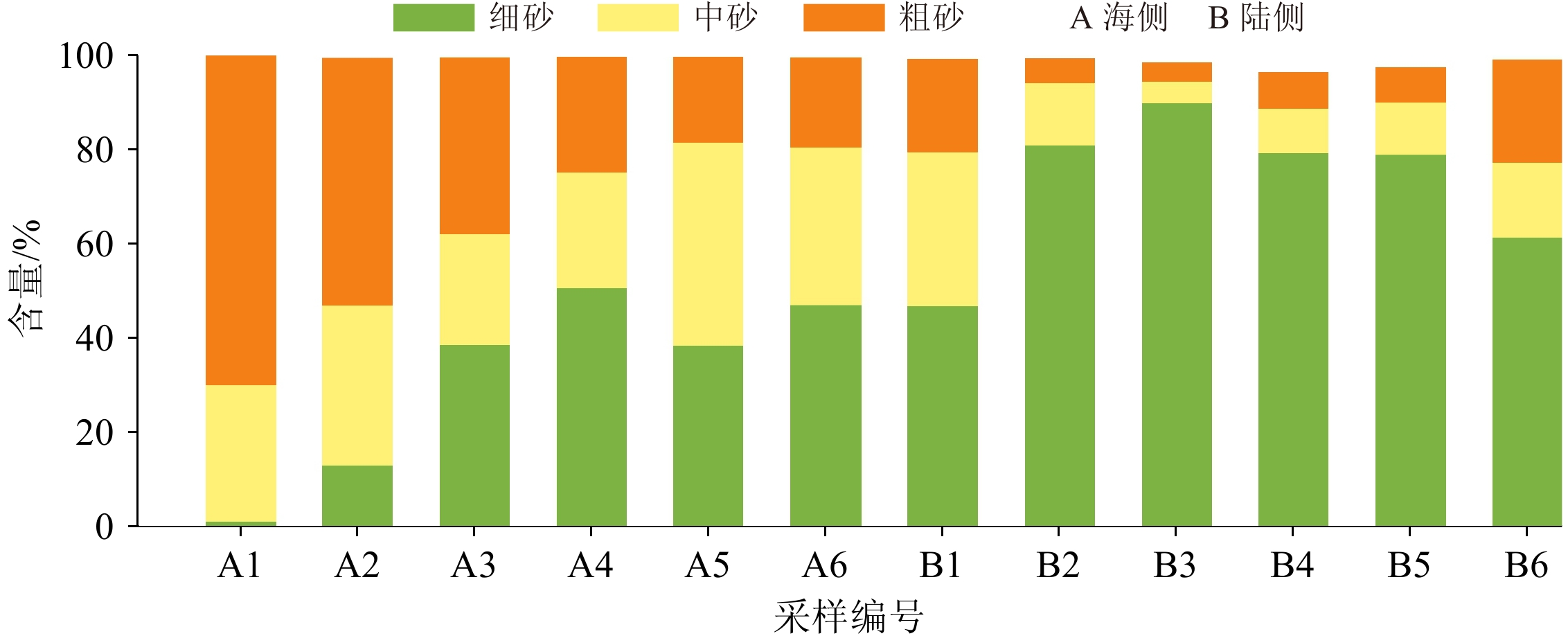
% 采样点编号 细砂 中砂 粗砂 海侧 陆侧 海侧 陆侧 海侧 陆侧 1 1.042 46.76 28.871 32.74 70.056 19.671 2 12.978 80.948 33.86 13.197 52.584 5.176 3 38.535 89.8 23.576 4.582 37.44 4.098 4 50.476 79.26 24.607 9.414 24.627 7.816 5 38.416 78.855 43.076 11.034 18.268 7.558 6 46.968 61.298 33.398 15.933 19.245 21.861
下载: 导出CSV
表 3 沙嘴平均粒径、分选系数、偏态、峰态
Table 3. The particle size parameters of average size, sorting coefficient, skewness, and kurtosis of the sand split
采样点编号 平均粒径/µm 分选系数 偏态 峰态 海侧 陆侧 海侧 陆侧 海侧 陆侧 海侧 陆侧 1 607.9734 280.4785 0.544503 0.923458 0.34374 0.453595 0.780876 1.385656 2 498.4276 187.6972 0.806415 0.704203 0.472333 0.334179 1.053235 1.170949 3 360.508 163.092 1.092031 0.741816 0.127668 0.443639 1.401985 1.361979 4 283.9223 207.8505 0.969367 1.065781 0.321818 0.641114 1.226198 1.793195 5 306.0457 205.969 0.773283 0.951842 0.220212 0.549042 1.106709 1.629662 6 289.9574 259.8288 0.858083 1.057971 0.33533 0.41259 1.174146 1.500453
下载: 导出CSV
表 4 涠洲岛海洋站洪枯季平均波高与波向统计
Table 4. Statistics of average wave height and wave direction in flood and dry season at Ocean Observation Station in Weizhou Island
洪/枯 季 平均波高/m 主要波向 洪季 0.775 SSW 枯季 0.475 NNE
下载: 导出CSV
表 5 北海潮位站2021年洪枯季最大潮差与平均潮差统计
Table 5. Statistics of the maximum tidal range and average tidal range observed at Tide Gauge Station in Beihai in flood and dry seasons in 2021
洪/枯 季 最大潮差/m 平均潮差/m 洪季 5.11 3.18 枯季 5.12 3.16
下载: 导出CSV
表 6 沙嘴1995至2000年影像详细信息及对应潮位
Table 6. Specifications of the satellite images and corresponding tide levels of the sand spit from 1995 to 2000
年份 卫星 影像日期 对应潮位 1995 Landsat-5 1995-05-25 11:30 150 1996 Landsat-5 1996-05-27 11:30 90 1997 Landsat-5 1997-05-14 11:30 122 1998 Landsat-5 1998-08-21 11:30 236 1999 Landsat-5 1999-06-02 11:30 183 2000 Landsat-5 2000-05-06 11:30 253
下载: 导出CSV
-
[1] Leonardi N, Canestrelli A, Sun T, et al. Effect of tides on mouth bar morphology and hydrodynamics[J]. Journal of Geophysical Research: Oceans, 2013, 118(9):4169-4183. doi: 10.1002/jgrc.20302
[2] Dinis P A, Huvi J, Cascalho J, et al. Sand-spits systems from Benguela region (SW Angola). An analysis of sediment sources and dispersal from textural and compositional data[J]. Journal of African Earth Sciences, 2016, 117:171-182. doi: 10.1016/j.jafrearsci.2016.01.020
[3] Saengsupavanich C. Morphological evolution of sand spits in Thailand[J]. Marine Geodesy, 2021, 44(5):432-453. doi: 10.1080/01490419.2021.1893873
[4] Pradhan U, Mishra P, Mohanty P K, et al. Formation, growth and variability of sand spit at Rushikulya River Mouth, South Odisha Coast, India[J]. Procedia Engineering, 2015, 116:963-970. doi: 10.1016/j.proeng.2015.08.387
[5] Bastos L, Bio A, Pinho J L S, et al. Dynamics of the Douro estuary sand spit before and after breakwater construction[J]. Estuarine, Coastal and Shelf Science, 2012, 109:53-69. doi: 10.1016/j.ecss.2012.05.017
[6] 刘宝银, 王岩峰, 高俊国. 近期黄河口沙嘴演变遥感信息的拓扑模型研究[J]. 海洋学报, 2000, 22(2):41-47 doi: 10.3321/j.issn:0253-4193.2000.02.006
LIU Baoyin, WANG Yanfeng, GAO Junguo. Remote sensing information topological pattern research on recent evolution of sand spit of the Huanghe River’s mouth[J]. Acta Oceanologica Sinica, 2000, 22(2):41-47.] doi: 10.3321/j.issn:0253-4193.2000.02.006
[7] 郭建强, 茅志昌. 长江口瑞丰沙嘴演变分析[J]. 海洋湖沼通报, 2008(1):17-24 doi: 10.3969/j.issn.1003-6482.2008.01.003
GUO Jianqiang, MAO Zhichang. Analysis on the revolution of Ruifengshan spit in Yangtze Estuary[J]. Transactions of Oceanology and Limnology, 2008(1):17-24.] doi: 10.3969/j.issn.1003-6482.2008.01.003
[8] Teodoro A C, Pais-Barbosa J, Gonçalves H, et al. Extraction of Cabedelo sand spit area (Douro estuary) from satellite images through image processing techniques[J]. Journal of Coastal Research, 2011(S64):1740-1744.
[9] Hoang V C. Long-term evolution of morphology at Loc an estuary, Vung Tau, Vietnam[J]. Marine Geodesy, 2020, 43(2):163-188. doi: 10.1080/01490419.2019.1606125
[10] Bergsma E W J, Sadio M, Sakho I, et al. Sand-spit evolution and inlet dynamics derived from space-borne optical imagery: is the Senegal-River inlet closing?[J]. Journal of Coastal Research, 2020, 95(sp1):372-376. doi: 10.2112/SI95-072.1
[11] Zhang H G, Li D L, Wang J, et al. Long time-series remote sensing analysis of the periodic cycle evolution of the inlets and ebb-tidal delta of Xincun Lagoon, Hainan Island, China[J]. ISPRS Journal of Photogrammetry and Remote Sensing, 2020, 165:67-85. doi: 10.1016/j.isprsjprs.2020.05.006
[12] 李鹏, 陈沈良, 刘清兰, 等. 黄河尾闾沙洲及河口形态对水沙变化的响应[J]. 泥沙研究, 2022, 47(2):57-64
LI Peng, CHEN Shenliang, LIU Qinglan, et al. Responses of the processes in the Yellow River lowermost channel sandbars and estuary to the variation of water and sediment[J]. Journal of Sediment Research, 2022, 47(2):57-64.]
[13] Allard J, Bertin X, Chaumillon E, et al. Sand spit rhythmic development: a potential record of wave climate variations? Arçay Spit, western coast of France[J]. Marine Geology, 2008, 253(3-4):107-131. doi: 10.1016/j.margeo.2008.05.009
[14] Dan S, Walstra D J R, Stive M J F, et al. Processes controlling the development of a river mouth spit[J]. Marine Geology, 2011, 280(1-4):116-129. doi: 10.1016/j.margeo.2010.12.005
[15] Duc Anh N Q, Tanaka H, Tam H S, et al. Comprehensive study of the sand spit evolution at tidal inlets in the central coast of Vietnam[J]. Journal of Marine Science and Engineering, 2020, 8(9):722. doi: 10.3390/jmse8090722
[16] Hoan L X, Hanson H, Larson M, et al. A mathematical model of spit growth and barrier elongation: Application to Fire Island Inlet (USA) and Badreveln Spit (Sweden)[J]. Estuarine, Coastal and Shelf Science, 2011, 93(4):468-477. doi: 10.1016/j.ecss.2011.05.033
[17] Hiep N T, Tanaka H, Tinh N X. Morphology recovery of the Abukuma River mouth after the 2011 Tohoku tsunami under the interaction between sand spit and sand terrace[J]. Coastal Engineering Journal, 2021, 63(4):467-484. doi: 10.1080/21664250.2021.1937902
[18] Chi S H, Zhang C, Wang P, et al. Morphological evolution of paired sand spits at the Fudu river mouth: Wave effects and anthropogenic factors[J]. Marine Geology, 2023, 456:106991. doi: 10.1016/j.margeo.2023.106991
[19] 莫永杰. 广西溺谷湾海岸地貌特征[J]. 海洋通报, 1990, 9(6):57-60
MO Yongjie. Geomorphic features of drowned valley bays of Guangxi coast[J]. Marine Science Bulletin, 1990, 9(6):57-60.]
[20] 中国海湾志编纂委员会. 中国海湾志[M]. 北京: 海洋出版社, 1993, 12
China Gulf Chronicles Compilation Committee. Chinese Gulf Chronicles[M]. Beijing: Ocean Press, 1993, 12.]
[21] 王日明, 戴志军, 黄鹄, 等. 北部湾大风江与南流江河口红树林空间分布格局研究[J]. 海洋学报, 2020, 42(12):54-61
WANG Riming, DAI Zhijun, HUANG Hu, et al. Spatial patterns of the mangrove along the riverine estuaries, Nanliujiang River and Dafengjiang River of the Beibu Gulf[J]. Haiyang Xuebao, 2020, 42(12):54-61.]
[22] 黎树式, 戴志军. 南流江现代水文−地貌过程[M]. 北京: 海洋出版社, 2018
LI Shushi, DAI Zhijun. Modern hydrological-geomorphological processes of the Nanliu River[M]. Beijing: Ocean Press, 2018.]
[23] Long C Q, Dai Z J, Wang R M, et al. Dynamic changes in mangroves of the largest delta in northern Beibu Gulf, China: reasons and causes[J]. Forest Ecology and Management, 2022, 504:119855. doi: 10.1016/j.foreco.2021.119855
[24] Gorelick N, Hancher M, Dixon M, et al. Google earth engine: planetary-scale geospatial analysis for everyone[J]. Remote Sensing of Environment, 2017, 202:18-27. doi: 10.1016/j.rse.2017.06.031
[25] 高抒. 沉积物粒径趋势分析: 原理与应用条件[J]. 沉积学报, 2009, 27(5):826-836
GAO Shu. Grain size trend analysis: principle and applicability[J]. Acta Sedimentologica Sinica, 2009, 27(5):826-836.]
[26] 赵建春, 戴志军, 李九发, 等. 强潮海湾近岸表层沉积物时空分布特征及水动力响应: 以杭州湾北岸为例[J]. 沉积学报, 2008, 26(6):1043-1051
ZHAO Jianchun, DAI Zjijun, LI Jiufa, et al. Study on the characteristics of temporal and spatial changes in properties of surface sediment on near-shore seabed of strong-tide bay: a case from the north bank of Hangzhou Bay in Shanghai[J]. Acta Sedimentologica Sinica, 2008, 26(6):1043-1051.]
[27] 黄子眉, 张春华, 申友利, 等. 涠洲岛海域风侯和波侯特征分析[J]. 海洋预报, 2021, 38(2):62-68
HUANG Zimei, ZHANG Chunhua, SHEN Youli, et al. Analysis of the climatic characteristics of wind and wave in Weizhou Island sea area[J]. Marine Forecasts, 2021, 38(2):62-68.]
[28] 黄鹄, 戴志军, 施伟勇, 等. 强潮环境下的海滩剖面沉积特征: 以春季广西北海银滩为例[J]. 热带海洋学报, 2011, 30(4):71-76 doi: 10.3969/j.issn.1009-5470.2011.04.011
HUANG Hu, DAI Zhijun, SHI Weiyong, et al. Deposition characteristics of beach profile in strong-tidal environment: a case study of Yintan, Guangxi during spring[J]. Journal of Tropical Oceanography, 2011, 30(4):71-76.] doi: 10.3969/j.issn.1009-5470.2011.04.011
[29] Lane E W. Report of the subcommittee on sediment terminology[J]. Eos, Transactions American Geophysical Union, 1947, 28(6):936-938. doi: 10.1029/TR028i006p00936
[30] 李晓敏, 张杰, 马毅, 等. 罗斗沙岛动态变化的遥感监测[J]. 海洋学研究, 2013, 31(2):52-58 doi: 10.3969/j.issn.1001-909X.2013.02.007
LI Xiaomin, ZHANG Jie, MA Yi, et al. Monitoring the dynamic change of Luodousha Island using remote sensing technology[J]. Journal of Marine Sciences, 2013, 31(2):52-58.] doi: 10.3969/j.issn.1001-909X.2013.02.007
[31] 陶旭, 张东. 潮滩滩面高程的高光谱遥感反演研究[J]. 海洋科学进展, 2013, 31(4):498-507 doi: 10.3969/j.issn.1671-6647.2013.04.008
TAO Xu, ZHANG Dong. Inversion of tidal flat elevation based on Hyperspectral remote sensing[J]. Advances in Marine Science, 2013, 31(4):498-507.] doi: 10.3969/j.issn.1671-6647.2013.04.008
[32] 刘吉平, 董春月, 刘家福, 等. 三江平原孤立湿地空间分布及其影响因素[J]. 生态学报, 2016, 36(11):3280-3291
LIU Jiping, DONG Chunyue, LIU Jiafu, et al. Analysis of isolated wetland spatial distribution and factors influencing it in the Sanjiang Plain, China[J]. Acta Ecologica Sinica, 2016, 36(11):3280-3291.]
[33] 何安尤, 周解, 朱瑜, 等. 大风江渔业自然资源调查[C]//广西水产研究所论文集. 南宁: 广西壮族自治区科学技术协会, 2006: 159-167
HE Anyou, ZHOU Jie, ZHU Yu, et al. Dafeng River fishery natural resources survey[C]. Nanning: Guangxi Association for Science and Technology, 2006: 159-167.]
[34] 杨洋, 陈沈良, 徐丛亮. 黄河口滨海区冲淤演变与潮流不对称[J]. 海洋学报, 2021, 43(6):13-25
YANG Yang, CHEN Shenliang, XU Congliang. Morphodynamics and tidal flow asymmetry of the Huanghe River Estuary[J]. Haiyang Xuebao, 2021, 43(6):13-25.]
[35] 庞文鸿. 中强潮海滩沉积动力过程研究: 以北海银滩为例[D]. 华东师范大学博士学位论文, 2021
PANG Wenhong. Sediment dynamic processes in meso-macro tidal beaches: a case study of Yintan beach in Beihai city[D]. Doctoral Dissertation of East China Normal University, 2021.]
-


图(12)
表(6)
计量
- 文章访问数: 174
- PDF下载数: 21
- 施引文献: 0