

Topographic and geomorphological characteristics and development pattern of gravel beaches along the coast of Zhejiang Province
-
摘要:
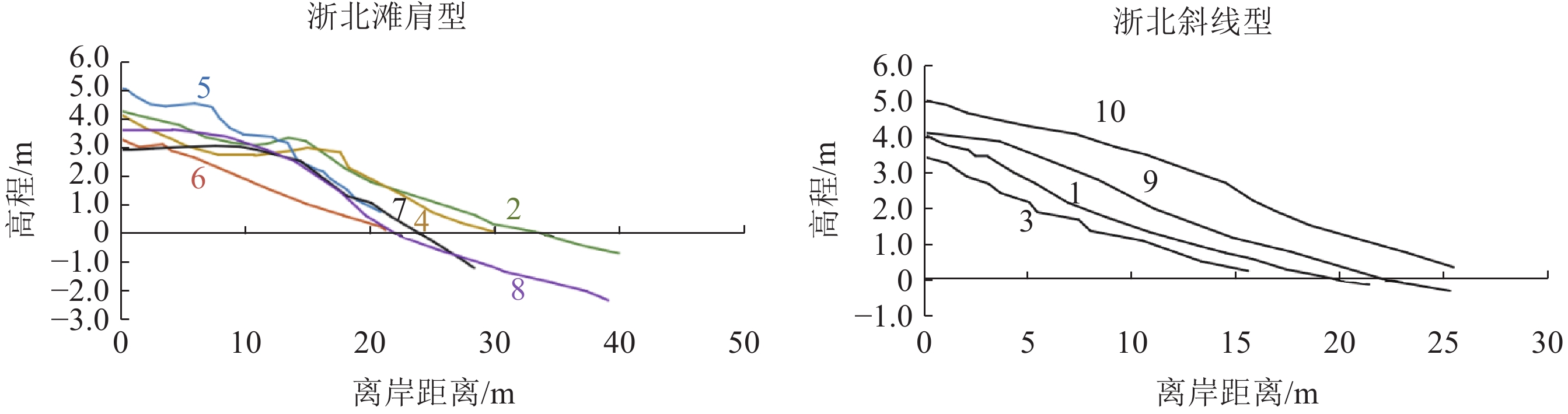
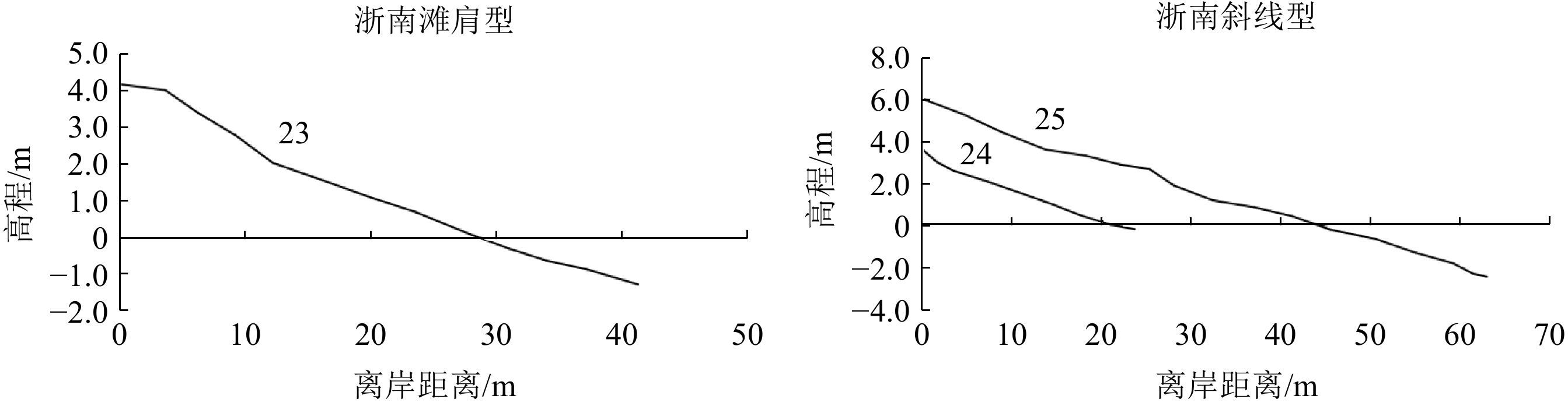
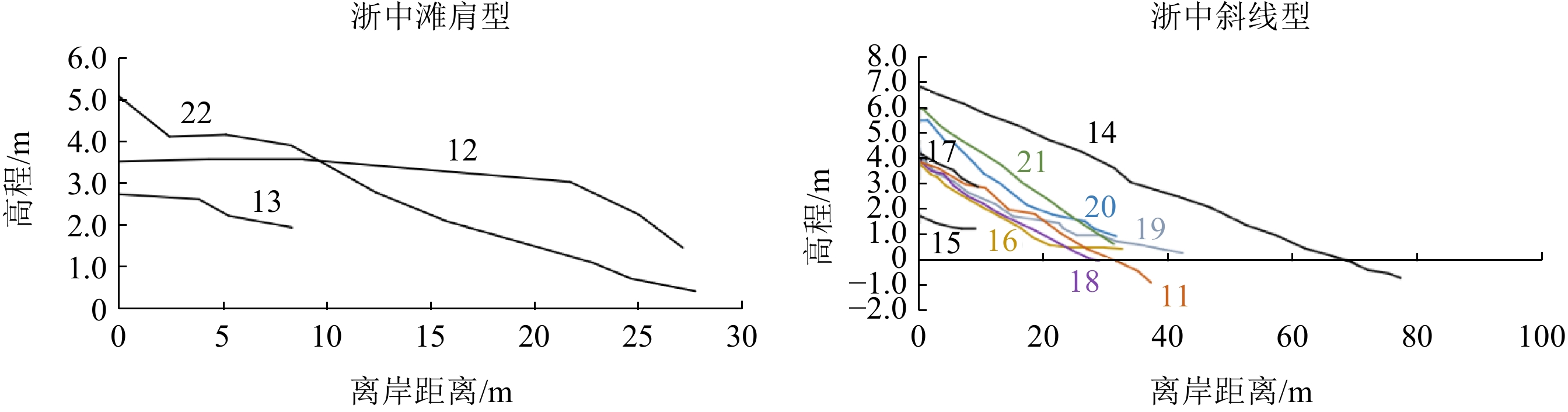
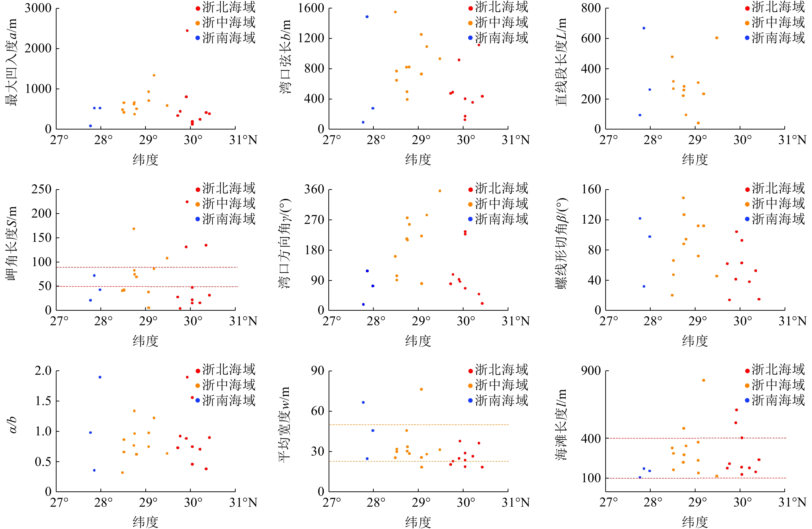
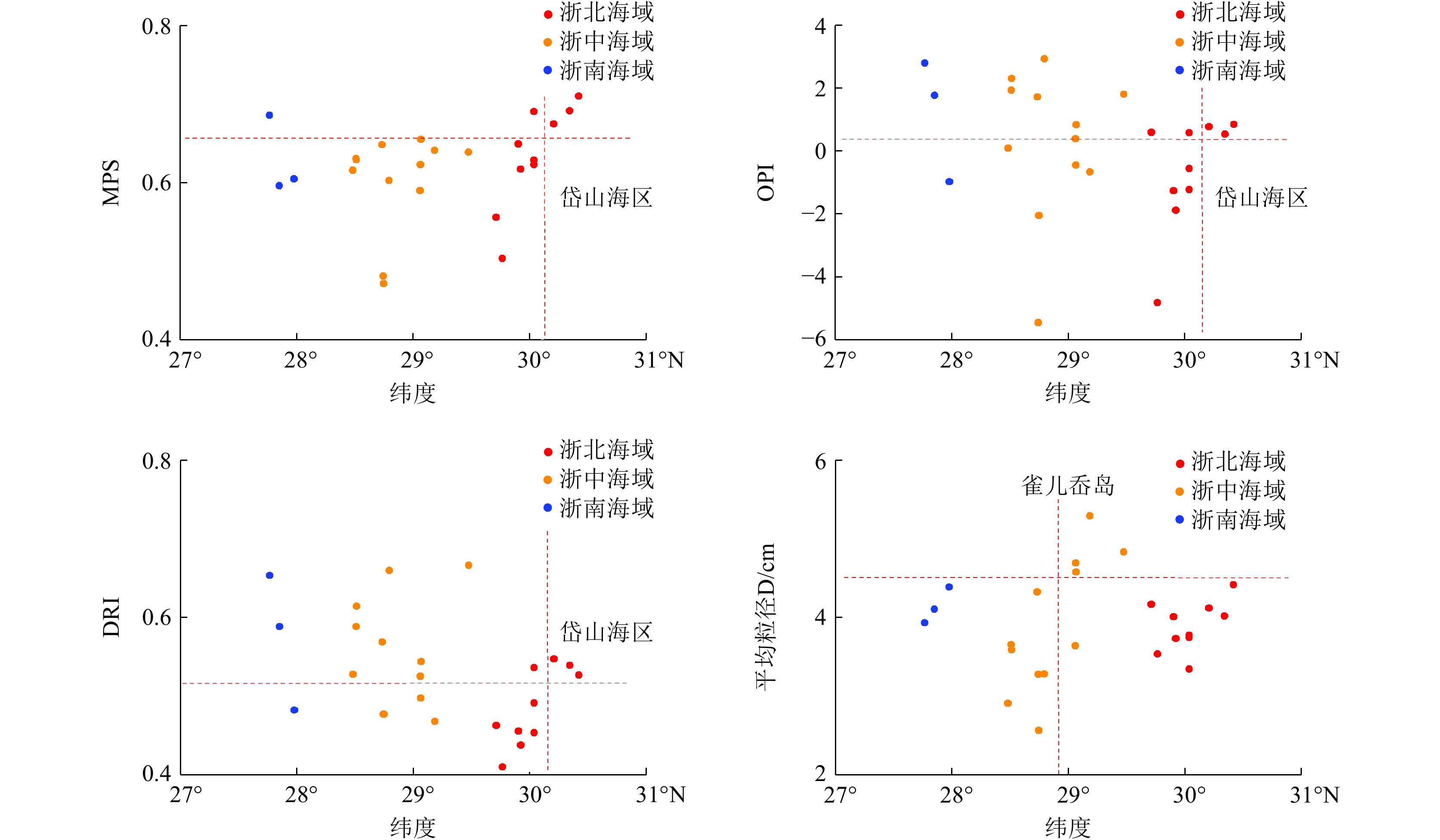
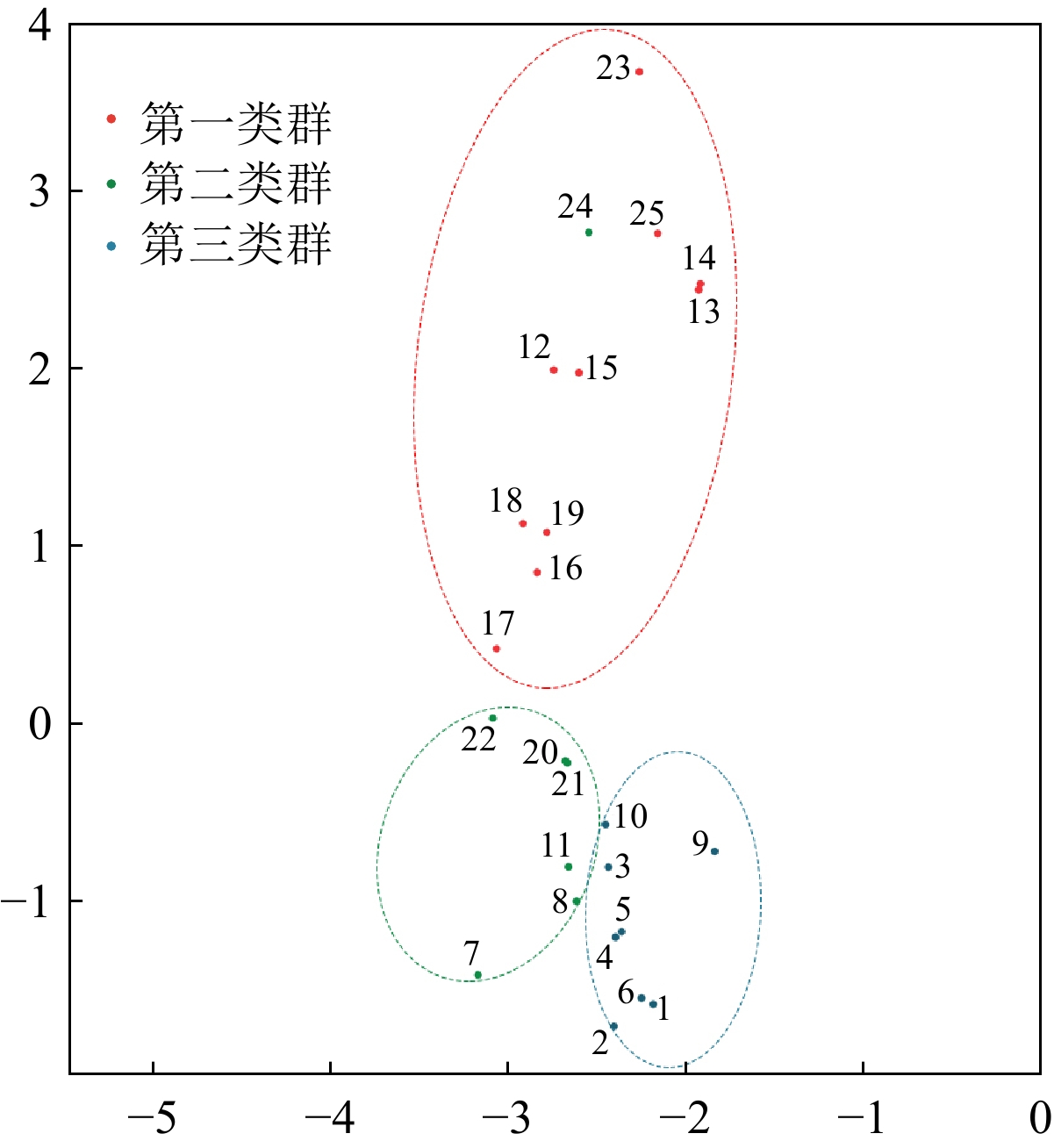
利用2019年7月和2020年7—8月的浙江省海滩现场调查数据,结合历史数据资料,系统分析了浙江省不同区域砾石滩的剖面地形特征、平面形态特征和表层沉积物粒度特征; 同时, 利用相关性分析、主成分分析、聚类分析和非度量多维尺度分析等数理统计方法,探讨了影响浙江砾石滩发育的主要因子,阐明了浙江砾石滩的发育模式。结果表明:① 从剖面形态可以看出,浙江砾石滩剖面形态大多呈斜线型,部分砾石滩呈肩滩型。从平面形态可以看出,浙中海域砾石滩海滩规模较大,岬角遮蔽能力较弱,因此受到的波浪作用最强。从沉积物粒度分布特征可以看出,浙中海域雀儿岙岛以北的砾石滩沉积物较粗,而浙中海域和浙南海域砾石滩则具有较多的扁长和杆状砾石。② 浙江砾石滩可分为3个类群:第一类群主要分布在浙中浙南海域,受潮流作用较强;第二类群主要分布在浙北海域,受潮汐作用较弱,规模较小,而第三类群分布较为分散,规模较大。③ 地质构造背景、水动力环境以及沉积物来源等对浙江砾石滩的形成过程具有重要的影响,其中地质构造背景是海滩发育的主要影响因素。砾石滩在进行生态保护和生态恢复过程中,还需要考虑波浪作用和潮汐作用的影响。
Abstract:Using on-site survey data from July 2019 and July-August 2020 in Zhejiang Province, combined with historical data, we systematically analyzed the characteristics of topological profiles, planar morphology, and surface sediment grain size of gravel beaches in various locations of Zhejiang Province. Meanwhile, using mathematical statistical methods such as correlation analysis, principal component analysis, cluster analysis, and non-metric multidimensional scaling,, the main factors affecting the development of the gravel beaches were explored, and the development pattern of the gravel beaches was elucidated. Results indicate that in the profile morphology, it can be seen that most of the gravel beach profiles are oblique line typed, and some of them have a beach berm. In planform, gravel beaches in the central Zhejiang sea area are relatively larger, have weaker headland, and thus the shielding ability is weak and undergo stronger wave action. In distribution pattern of sediment particle size, the gravel beaches north of Que'er Ao Island in the central Zhejiang sea area have coarsest pebbles and thicker deposits, while those in the central and southern Zhejiang sea areas have more prolate and club-shaped gravels. The gravel beaches in Zhejiang could be placed into three groups by cluster analysis. The first group is mainly seen in the central and southern Zhejiang, and is strongly affected by tidal currents. The second group is mainly distributed in the northern Zhejiang, with weaker tidal effects and smaller. The third group distributed more sporadically in the province and relatively coarser. The geological structure background, hydrodynamic environment, and sediment supply have important impacts on the formation process of the gravel beaches, among which the geological structure background is the main factor on beach development. For the ecological protection and ecological restoration regarding the gravel beaches, the influences of wave action and tidal action must be considered.
-
Key words:
- plane morphology /
- developmental pattern /
- profile morphology /
- sediment grain size /
- gravel beach
-

-
表 1 海滩测量位置和时间信息
Table 1. Specifications of survey on gravel beaches
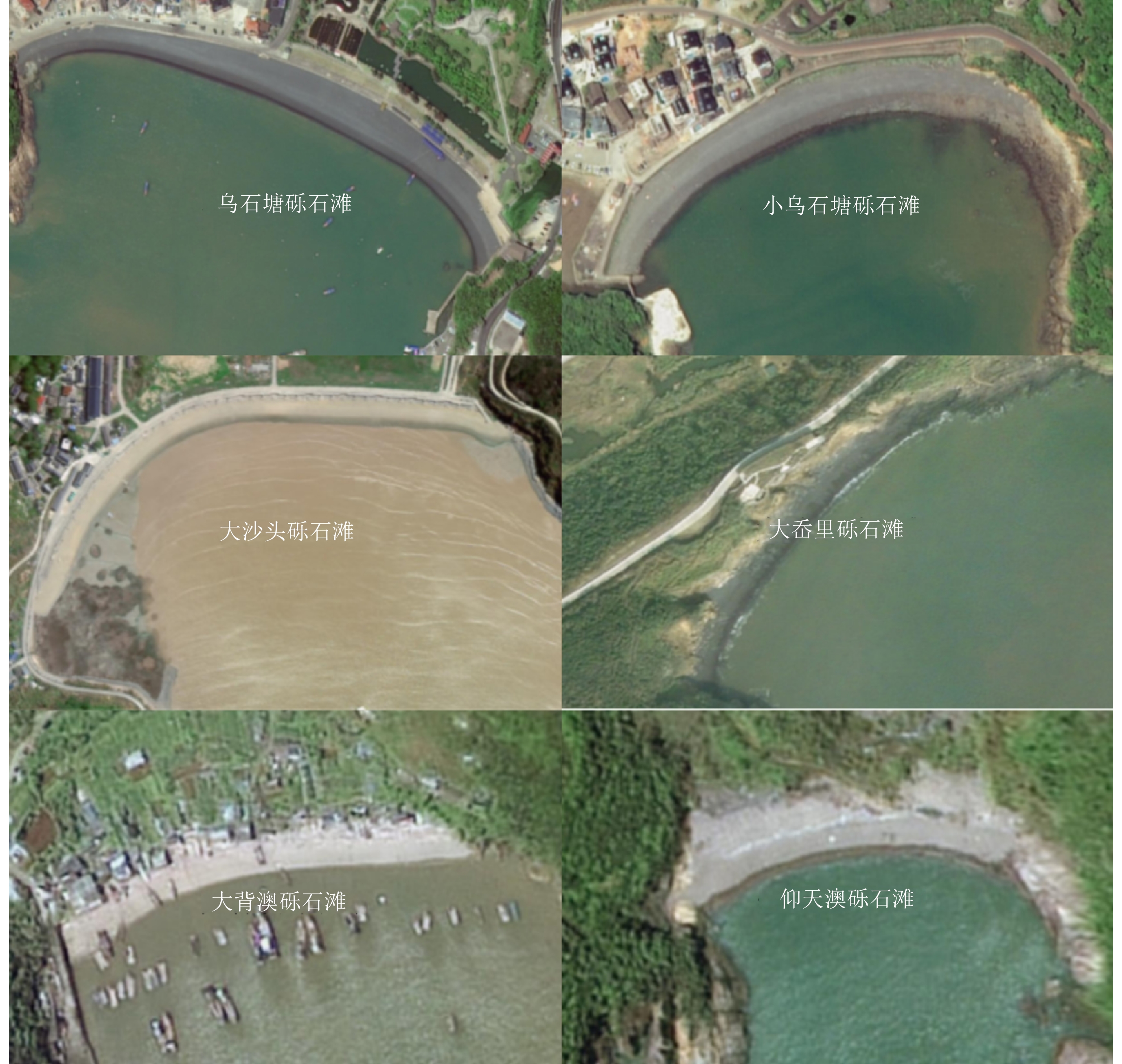
序号 海滩名称 所在地区 所在海域 测量时间 位置 平均潮差/m 平均波高/m 所在区域岩性 1 大沙碗砾石滩 舟山市 浙北海域 2020.7.13 30.42°N、122.43°E 2.28 1.10 熔结凝灰岩夹凝灰质砂岩 2 次蓬山砾石滩 舟山市 浙北海域 2020.7.10 30.34°N、122.18°E 1.91 1.10 熔结凝灰岩 3 西风湾砾石滩 舟山市 浙北海域 2020.7.4 30.2°N、122.7°E 2.62 1.10 碱长花岗岩 4 老佃厂砾石滩 舟山市 浙北海域 2020.7.7 30.04°N、122.42°E 2.32 0.50 熔结凝灰岩夹凝灰质砂岩 5 前沙砾石滩 舟山市 浙北海域 2020.7.7 30.03°N、122.42°E 2.32 0.50 熔结凝灰岩夹凝灰质砂岩 6 岙里沙砾石滩 舟山市 浙北海域 2020.7.7 30.03°N、122.43°E 2.32 0.50 熔结凝灰岩夹凝灰质砂岩 7 乌石塘砾石滩 舟山市 浙北海域 2019.7 29.92°N、122.4°E 2.42 0.50 碱长花岗岩 8 小乌石塘砾石滩 舟山市 浙北海域 2019.7 29.9°N、122.42°E 2.42 0.50 碱长花岗岩 9 倒座厅砾石滩 舟山市 浙北海域 2020.8.24 29.76°N、122.24°E 2.75 0.50 碱性花岗岩 10 马跳头砾石滩 舟山市 浙北海域 2020.8.24 29.71°N、122.22°E 2.75 0.50 花岗斑岩 11 羊背山砾石滩 宁波市 浙中海域 2020.8.29 29.47°N、121.98°E 2.45 0.40 碱长花岗岩 12 大沙头砾石滩 宁波市 浙中海域 2020.8.19 29.18°N、122.04°E 3.62 0.40 含角砾熔结凝灰岩 13 狼箕山咀砾石滩 宁波市 浙中海域 2020.8.17 29.07°N、121.83°E 3.84 0.50 石英正长斑岩 14 天作塘砾石滩 宁波市 浙中海域 2020.8.17 29.06°N、121.83°E 3.84 0.50 石英正长斑岩 15 小花岙砾石滩 宁波市 浙中海域 2020.8.17 29.06°N、121.82°E 3.84 0.50 石英正长斑岩 16 大澳坑砾石滩 台州市 浙中海域 2020.8.13 28.79°N、121.85°E 3.60 0.50 含角砾熔结凝灰岩 17 大网坑砾石滩 台州市 浙中海域 2020.8.12 28.75°N、121.85°E 3.60 0.50 熔结凝灰岩 18 田岙砾石滩 台州市 浙中海域 2020.8.12 28.74°N、121.85°E 3.60 0.50 熔结凝灰岩 19 黄夫澳砾石滩 台州市 浙中海域 2020.8.12 28.73°N、121.86°E 3.60 0.50 熔结凝灰岩 20 帽后沙砾石滩 台州市 浙中海域 2020.8.16 28.51°N、121.89°E 3.39 0.50 熔结凝灰岩与流纹岩、流纹斑岩互层 21 虾捕砾石滩 台州市 浙中海域 2020.8.16 28.51°N、121.89°E 3.39 0.50 熔结凝灰岩与流纹岩、流纹斑岩互层 22 大岙里砾石滩 台州市 浙中海域 2020.8.16 28.48°N、121.89°E 3.39 0.50 熔结凝灰岩 23 仰天澳砾石滩 温州市 浙南海域 2020.8.6 27.98°N、121.19°E 4.26 0.30 熔结凝灰岩夹凝灰质砂岩与流纹岩 24 大背澳砾石滩 温州市 浙南海域 2020.8.5 27.85°N、121.06°E 4.01 0.30 熔结凝灰岩 25 南策砾石滩 温州市 浙南海域 2020.8.5 27.77°N、121.13°E 4.01 1.00 熔结凝灰岩  下载: 导出CSV
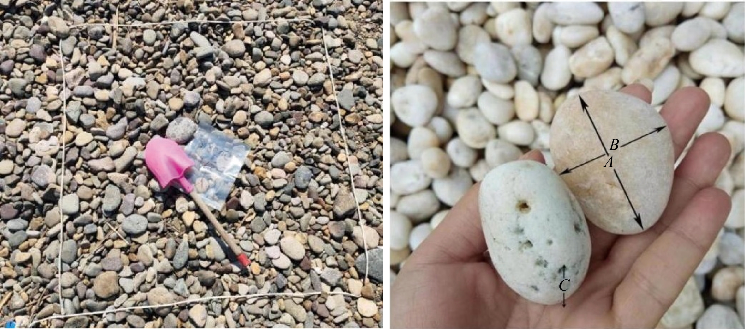
表 2 砾石形态参数计算方法及指示意义
Table 2. Calculation methods and referential meaning of gravel shape parameters
形态参数 计算公式 指示意义 D $ D=\dfrac{\sum {D}_{n}}{n} $ $ {D}_{n}=\sqrt[3]{A\times B\times C} $ / MPS [C2/(A×B)]1/3 反映的是在流体中拖曳力与重力作用的平衡,是表征水中砾石发生搬运或沉降行为的一个重要指标,球度值越大,说明磨蚀作用越长 OPI 10×[(A–B)/(A–C)–0.5]/(C/A) 用来从扁长砾石中分辨出扁圆砾石的一个非常有用的指标,数值越大,扁长砾石越多 DRI (A–B)/(A–C) 用来分辨杆状砾石和盘状砾石的一个非常有效的指标,数值越大,杆状砾石占比越大
下载: 导出CSV
表 3 沉积物粒径信息
Table 3. Specifications of sediment grain-size parameters
序号 海滩名称 MPS OPI DRI 平均粒径/cm 1 大沙碗砾石滩 0.71 0.85 0.53 4.42 2 次蓬山砾石滩 0.69 0.54 0.54 4.03 3 西风湾砾石滩 0.67 0.78 0.55 4.12 4 老佃厂砾石滩 0.63 −1.22 0.45 3.75 5 前沙砾石滩 0.69 0.59 0.54 3.78 6 岙里沙砾石滩 0.62 −0.55 0.49 3.35 7 乌石塘砾石滩 0.62 −1.87 0.44 3.74 8 小乌石塘砾石滩 0.65 −1.26 0.46 4.01 9 倒座厅砾石滩 0.50 −4.82 0.41 3.54 10 马跳头砾石滩 0.56 0.60 0.46 4.17 11 羊背山砾石滩 0.64 1.81 0.67 4.84 12 大沙头砾石滩 0.64 −0.65 0.47 5.30 13 狼箕山咀砾石滩 0.65 0.84 0.54 4.58 14 天作塘砾石滩 0.62 −0.44 0.50 4.70 15 小花岙砾石滩 0.59 0.39 0.53 3.65 16 大澳坑砾石滩 0.60 2.93 0.66 3.29 17 大网坑砾石滩 0.47 −2.04 0.48 2.57 18 田岙砾石滩 0.48 −5.45 0.48 3.28 19 黄夫澳砾石滩 0.65 1.72 0.57 4.33 20 帽后沙砾石滩 0.63 2.31 0.61 3.60 21 虾捕砾石滩 0.63 1.93 0.59 3.66 22 大岙里砾石滩 0.62 0.10 0.53 2.92 23 仰天澳砾石滩 0.60 −0.96 0.48 4.39 24 大背澳砾石滩 0.60 1.77 0.59 4.11 25 南策砾石滩 0.69 2.80 0.65 3.94
下载: 导出CSV
表 4 砾石滩各主成分特征值、方差贡献率和累计贡献率
Table 4. The eigenvalues, variance contribution rate and accumulated contribution rate of principal components of gravel beaches
主成分 特征值 方差贡献率/% 累计方差贡献率/% 1 3.107 28.247 28.247 2 2.261 20.552 48.798 3 1.596 14.510 63.309 4 1.106 10.053 73.362 5 1.059 9.625 82.987 6 0.810 7.367 90.354 7 0.424 3.852 94.206 8 0.347 3.154 97.360 9 0.163 1.481 98.841 10 0.090 0.816 99.657 11 0.038 0.343 100.000
下载: 导出CSV
表 5 砾石滩指标因子在主成分中的载荷
Table 5. Loads of principal components index factor of gravel beaches
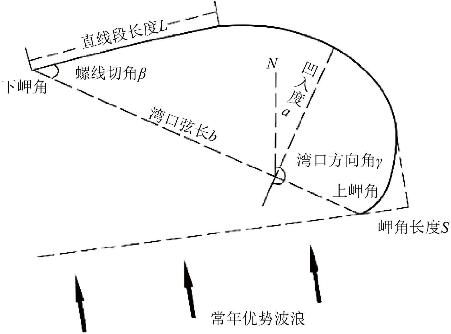
因子 $ i $ Mz a L b S γ β a/b TR $ \overline{H} $ 第一主成分 −0.130 0.041 0.257 0.227 0.214 0.217 0.104 0.150 0.096 0.123 −0.188 第二主成分 0.333 0.292 0.108 0.208 0.206 0.189 −0.074 −0.290 −0.121 −0.007 0.096 第三主成分 0.156 0.121 0.250 −0.134 −0.242 0.164 −0.312 0.166 0.507 −0.144 0.138 第四主成分 −0.150 0.222 0.008 −0.228 −0.071 0.333 0.526 0.279 −0.187 −0.387 0.354
下载: 导出CSV
-
[1] 王爱军, 高抒. 砾石海滩的沉积和形态动力特征[J]. 海洋地质与第四纪地质, 2003, 23(1):113-118
WANG Aijun, GAO Shu. Sedimentodynamic and morphodynamic characteristics of gravel beaches[J]. Marine Geology & Quaternary Geology, 2003, 23(1):113-118.]
[2] 李从先, 陈刚, 孙和平, 等. 古海滩砾石层与海平面变动[J]. 海洋科学, 1986, 10(4):1-4
LI Congxian, CHEN Gang, SUN Heping, et al. Fossil beach gravel as a record of sea level change[J]. Marine Sciences, 1986, 10(4):1-4.]
[3] 王永红. 海岸动力地貌学[M]. 北京: 科学出版社, 2012
WANG Yonghong. Coastal Dynamic Geomorphology[M]. Beijing: Science Press, 2012.]
[4] Hart B S, Plint A G. Gravelly shoreface and beachface deposits[M]//Plint A G. Sedimentary Facies Analysis: A Tribute to the Research and Teaching of Harold G. Reading. Oxford: Blackwell Science, 1995: 75-101.
[5] Carter R W G, Orford J D. The morphodynamics of coarse clastic beaches and barriers: a short- and long-term perspective[J]. Journal of Coastal Research, 1993(15):158-179.
[6] 李志强, 李维泉, 陈子燊, 等. 华南岬间弧形海岸平面形态影响因素及类型[J]. 地理学报, 2014, 69(5):595-606
LI Zhiqiang, LI Weiquan, CHEN Zishen, et al. Influencing factors and classifications of arc-shaped coasts in South China[J]. Acta Geographica Sinica, 2014, 69(5):595-606.]
[7] 戴志军, 李春初. 华南弧形海岸岸线形态与地貌发育模式[J]. 地理学报, 2004, 59(5):738-744
DAI Zhijun, LI Chunchu. Coastline configuration and geomorphologic development mode of arc-shaped coast in South China[J]. Acta Geographica Sinica, 2004, 59(5):738-744.]
[8] González M, Medina R. On the application of static equilibrium bay formulations to natural and man-made beaches[J]. Coastal Engineering, 2001, 43(3-4):209-225. doi: 10.1016/S0378-3839(01)00014-X
[9] Schiaffino C F, Brignone M, Ferrari M. Application of the parabolic bay shape equation to sand and gravel beaches on Mediterranean coasts[J]. Coastal Engineering, 2012, 59(1):57-63. doi: 10.1016/j.coastaleng.2011.07.007
[10] Sneed E D, Folk R L. Pebbles in the lower Colorado river, Texas a study in particle morphogenesis[J]. The Journal of Geology, 1958, 66(2):114-150. doi: 10.1086/626490
[11] Komar P D. Selective gravel entrainment and the empirical evaluation of flow competence[J]. Sedimentology, 1987, 34(6):1165-1176. doi: 10.1111/j.1365-3091.1987.tb00599.x
[12] 张海生. 浙江省海洋环境资源基本现状[M]. 北京: 海洋出版社, 2013
ZHANG Haisheng. Basic Status of Marine Environmental Resources in Zhejiang Province[M]. Being: China Ocean Press, 2013.]
[13] 程林, 时连强, 夏小明, 等. 浙江朱家尖岛东沙海滩沉积与地貌动态变化[J]. 海洋地质与第四纪地质, 2014, 34(1):37-44
CHENG Lin, SHI Lianqiang, XIA Xiaoming, et al. Sedimentation and recent morphological changes at Dongsha Beach, Zhujiajian Island, Zhejiang Province[J]. Marine Geology & Quaternary Geology, 2014, 34(1):37-44.]
[14] 郭俊丽, 时连强, 童宵岭, 等. 浙江朱家尖岛东沙海滩对热带风暴“娜基莉”的响应及风暴后的恢复[J]. 海洋学报, 2018, 40(9):137-147
GUO Junli, SHI Lianqiang, TONG Xiaoling, et al. The response to tropical storm Nakri and the restoration of Dongsha Beach in Zhujiajian Island, Zhejiang Province[J]. Acta Oceanologica Sinica, 2018, 40(9):137-147.]
[15] 王爱军, 高抒, 杨旸. 浙江朱家尖岛砾石海滩沉积物分布及形态特征[J]. 南京大学学报:自然科学, 2004, 40(6):747-759
WANG Aijun, GAO Shu, YANG Yang. Sediment distribution and shape characteristics of gravel beaches, Zhujiajian Island, Zhejiang Province[J]. Journal of Nanjing University:Natural Sciences, 2004, 40(6):747-759.]
[16] 张敏. 浙江省沿岸海滩地形地貌特征与发育模式研究[D]. 杭州: 自然资源部第二海洋研究所, 2021
ZHANG Min. Study on geomorphological characteristics and development model of beaches in Zhejiang Province[D]. Hangzhou: Second Institute of Oceanography, MNR, 2021.]
[17] 郭俊丽, 时连强, 陈沈良, 等. 台风季节朱家尖岛砂、砾质岬湾海滩的不同沉积地貌动态变化[J]. 热带海洋学报, 2022, 41(4):82-96
GUO Junli, SHI Lianqiang, CHEN Shenliang, et al. Dynamic variations of different sedimentary geomorphology of sandy and gravel embayed beaches on the Zhujiajian Island during typhoon season[J]. Journal of Tropical Oceanography, 2022, 41(4):82-96.]
[18] 王康墡. 浙江省海岛资源综合调查[R]. 杭州: 国家海洋局第二海洋研究所, 1994
WANG Kangshan. Comprehensive survey of island resources in Zhejiang Province[R]. Hangzhou: Second Institute of Oceanography, State Oceanic Administration, 1994.]
[19] 中国海湾志编纂委员会. 中国海湾志(第六分册): 浙江省南部海湾[M]. 北京: 海洋出版社, 1993
Compiling Council of Chinese Embayment. Chinese Embayment, Part 6[M]. Beijing: China Ocean Press, 1993.]
[20] Gale S J, Hoare P G. Bulk sampling of coarse clastic sediments for particle‐size analysis[J]. Earth Surface Processes and Landforms, 1992, 17(7):729-733. doi: 10.1002/esp.3290170709
[21] Landon R E. An analysis of beach pebble abrasion and transportation[J]. The Journal of Geology, 1930, 38(5):437-446. doi: 10.1086/623739
[22] 王文介. 粤东锯齿状海岸弧形砂质湾滩的发育[J]. 热带海洋, 1985, 4(2):15-21
WANG Wenjie. Development of the arc-shaped sandy beach at bays on the crenulate coast of east Guangdong[J]. Tropic Oceanology, 1985, 4(2):15-21.]
[23] Hsu J R C, Silvester R, Xia Y M. Applications of headland control[J]. Journal of Waterway, Port, Coastal, and Ocean Engineering, 1989, 115(3):299-310. doi: 10.1061/(ASCE)0733-950X(1989)115:3(299)
[24] 蔡锋, 苏贤泽, 曹惠美, 等. 华南砂质海滩的动力地貌分析[J]. 海洋学报, 2005, 27(2):106-114
CAI Feng, SU Xianze, CAO Huimei, et al. Analysis on morphodynamics of sandy beaches in South China[J]. Acta Oceanologica Sinica, 2005, 27(2):106-114.]
[25] 齐岩辛, 张岩, 陈美君, 等. 浙江海岛区地质遗迹资源及其价值[J]. 地质调查与研究, 2013, 36(4):311-317
QI Yanxin, ZHANG Yan, CHEN Meijun, et al. Geoheritage resources and their value in the Island Area, Zhejiang Province[J]. Geological Survey and Research, 2013, 36(4):311-317.]
[26] 陈俊兵, 刘龙龙, 吴振, 等. 杭州湾舟山群岛海域晚第四纪声学地层[J]. 海洋地质前沿, 2021, 37(12):49-57
CHEN Junbing, LIU Longlong, WU Zhen, et al. Shallow acoustic stratigraphy of the late quaternary in the Zhoushan Islands of Hangzhou Bay[J]. Marine Geology Frontiers, 2021, 37(12):49-57.]
[27] 包砺彦. 雷州半岛南部青安湾海滩的沉积特征和地形发育[J]. 热带海洋, 1989, 8(2):75-83
BAO Liyan. Sedimentary characteristics and landform developments of Qingan Bay Beach in southern Leizhou Peninsula[J]. Tropic Oceanology, 1989, 8(2):75-83.]
[28] Masselink G, Russell P, Blenkinsopp C, et al. Swash zone sediment transport, step dynamics and morphological response on a gravel beach[J]. Marine Geology, 2010, 274(1-4):50-68. doi: 10.1016/j.margeo.2010.03.005
-


图(12)
表(5)
计量
- 文章访问数: 396
- PDF下载数: 24
- 施引文献: 0