

Prediction criteria for groundwater potential zones in Kemuning District, Indonesia using the integration of geoelectrical and physical parameters
-
Abstract:
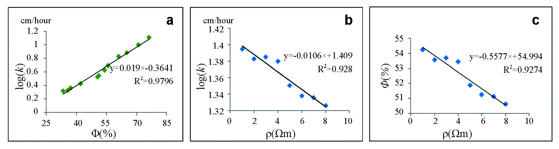
The presence of groundwater is strongly related to its geological and geohydrological conditions. It is, however, important to study the groundwater potential in an area before it is utilized to provide clean water. Werner-Schlumberger's method was used to analyze the groundwater potential while hydraulic properties such as soil porosity and hydraulic conductivity were used to determine the quality and ability of the soil to allow water's movement in the aquifer. The results show that the aquifer in the Sekara and Kemuning Muda is at a depth of more than 6 meters below the ground level with moderate groundwater potential. It is also found that the aquifer at depths of over 60 m have high groundwater potential. Moreover, soil porosity in Kemuning is found to be average while the ability to conduct water was moderate. This makes it possible for some surface water to seep into the soil while the remaining flows to the rivers and ditches.
-

-
Table 1. Coordinates of 12 measuring points in Kemuning
No. Location Latitude Longitude 1 Kerintang 00°51'35.81'' S 102°39'21.29'' E 2 Sekara 00°52'05.90'' S 102°44'41.30'' E 3 Kemuning Tua 00°54'14.23'' S 102°47'19.03'' E 4 Air Balui 00°53'46.67'' S 102°45'47.70'' E 5 Batu Ampar 00°58'20.49'' S 102°42'40.49'' E 6 Selensen 00°58'23.70'' S 102°45'22.74'' E 7 Tuk Jimun 00°54'52.46''S 102°48'02.06'' E 8 Kemuning Muda 00°53'48.90'' S 102°49'27.67'' E 9 Lubuk Besar 00°52'45.62'' S 102°50'05.44'' E 10 Talang Jangkang 00°51'20.83'' S 102°49'24.84'' E 11 Limau Manis 00°52'19.67'' S 102°48'24.63'' E 12 Sekayan 00°51'15.26'' S 102°41'03.11'' E  下载: 导出CSV
Table 2. Criteria of groundwater potential at Sekara and Kemuning Muda
Resistivity (Ωm) Type of layer Depth (m) Thickness (m) Location Potential criteria 145.59 Sand and pebble with enough water 6.88~14.29 7.41 Sekara at Layer 2 Medium 112.47 Sand and pebble with abundant water 73.18~110 36.82 Sekara at Layer 5 Large 70.79 Sand and pebble with enough water 6.20~17.31 11.11 Kemuning Muda at Layer 2 Medium 153.79 Sand and pebble with abundant water 63.38~96 32.62 Kemuning Muda at Layer 5 Large
下载: 导出CSV
Table 3. Characteristics of hydraulic properties in Kemuning
Location Porosity (%) Description of soil porosity Hydraulic conductivity (cm/h) Ability to conduct water Kerintang 55.75 Good 4.91 Medium Sekara 54.10 Good 4.21 Medium Kemuning Tua 61.00 Porosity 6.76 Fairly fast Air Balui 65.22 Porosity 7.63 Fairly fast Batu Ampar 37.25 Bad 2.31 Medium Selensen 33.51 Bad 2.10 Medium Tuk Jimun 71.00 Porosity 9.95 Fairly fast Kemuning Muda 51.19 Good 3.52 Medium Lubuk Besar 76.25 Porosity 12.77 Fairly fast Talang Jangkang 42.10 Porosity 2.70 Medium Limau Manis 50.72 Good 3.34 Medium Sekayan 35.75 Bad 2.12 Medium
下载: 导出CSV
-
Alley WM, Healy RW, LaBaugh JW, et al. 2002. Flow and storage in groundwater systems. Science, 296: 1985-1990. doi: 10.1126/science.1067123
Bechte TD, Nico G. 2017. Geoelectrical finger-printing of two contrasting ecohydrological peatland types in the Alps. Wetlands, 37: 875-884. doi: 10.1007/s13157-017-0921-5
Heriyanto H, Karya D, Choanji T, et al. 2019. Regression model in transitional geological environment for calculation farming and production of oil palm dominant factor in Indragiri Hilir Riau Province. Journal of Geoscience, Engineering, Environment and Technology, 4(1): 56-65. doi: 10.25299/jgeet.2019.4.1.2600
Islami N, Taib S, Yusoff I, et al. 2011. Time lapse chemical fertilizer monitoring in agri-culture sandy soil. International Journal of Environmental Scince Technology, 8: 765-780. doi: 10.1007/BF03326260
Juandi M, Syahril S. 2017. Empirical relationship between soil permeability and resistivity, and its application for determining the ground-water gross recharge in Marpoyan Damai, Pekanbaru, Indonesia. Water Practice and Technology, 12(3): 660-666. doi: 10.2166/wpt.2017.069
Juandi M, Surbakti A, Syech R, et al. 2017. Poten-tial of aquifers for groundwater exploitation using Cooper-Jacob Equation. Journal of Environmental Science and Technology, 10: 215-219. doi: 10.3923/jest.2017.215.219
Juandi M. 2019. Study of groundwater in the rock area using geoelectric survey. Journal of Ph-ysics Conference Series, 1351: 012010. doi: 10.1088/1742-6596/1351/1/012010
Juandi M. 2020. Water sustainability model for estimation of groundwater availability in Kemuning district, Riau-Indonesia. Journal of Groundwater Science and Engineering, 8(1): 20-29. http://gwse.iheg.org.cn/en/article/doi/10.19637/j.cnki.2305-7068.2020.01.003
Krüger JP, Dotterweich M, Kopf C, et al. 2017. Carbon balance of rewetted peatland forests in low mountain range areas, Germany. Pro-ceedings of EGU General Assembly Vienna, Austria, 3212, April 23-28.
Lenkey L, Hámori Z, Mihálffy P. 2005. Investiga-ting the hydrogeology of a water-supply area using direct-current vertical electrical sound-ings. Geophysics, 70(4): 11-19. http://scitation.aip.org/getabs/servlet/GetabsServlet?prog=normal&id=GPYSA7000070000004000H11000001&idtype=cvips&prog=normal
Loke MH, Chambers JE, Rucker DF, et al. 2013. Recent developments in the direct-current geoelectrical imaging method. Journal of Applied Geophysics, 95: 135-156. doi: 10.1016/j.jappgeo.2013.02.017
LU Chuan, LI Long, LIU Yan-guang, et al. 2014. Capillary pressure and relative permeability model uncertainties in simulations of geological CO2 sequestration. Journal of Groundwater Science and Engineering, 2(2): 1-17. http://gwse.iheg.org.cn/en/article/id/120
Muhammad J. 2020. Peat water purification by hybrid of slow sand filtration and coagulant treatment. Journal of Environmental Science and Technology, 13(1): 22-28. http://www.researchgate.net/publication/338647775_Peat_Water_Purification_by_Hybrid_of_Slow_Sand_Filtration_and_Coagulant_Treatment
Powlson DS, Whitmore AP, Goulding KW. 2011. Soil carbon sequestration to mitigate climate change: A critical reexamination to identify the true and the false. European Journal of Soil Science, 62(1): 42-55. doi: 10.1111/j.1365-2389.2010.01342.x
Revil A, Karaoulis M, Johnson T, et al. 2012. Review: Some low-frequency electrical me-thods for subsurface characterization and monitoring in hydrogeology. Hydrogeology Journal, 20: 617-658. doi: 10.1007/s10040-011-0819-x
Sheriff RE. 2002. Encyclopedic dictionary of applied geophysics, 4th edition. Society of Exploration Geophysicists, Tulsa, Oklahoma, USA: 30-34.
Silliman SE, Borum BI, Boukari M, et al. 2010. Issues of sustainability of coastal groundwater resources: Benin, West Africa. Sustainability, 2(8): 2652-2675. doi: 10.3390/su2082652
Sultan SA, Santos FAM. 2008. Evaluating sub-surface structures and stratigraphic units using 2D electrical and magnetic data at the area North Greater Cairo, Egypt, International Journal Applied Earth Observation and Geoinformation, 10: 56-67.
Telford WM, Geldart LP, Sheriff RE. 1991. Aplied Geophysic, 2nd Edition. New York: Cambridge University Press: 283-290.
Udmale P, Shrestha S, Ichikawa Y, et al. 2014. Assessing groundwater resource and its sus-tainability in drought prone area of India. Journal of Japan Society of Civil Engineers, Ser. B1 (Hydraulic Engineering), 58: 235-240. http://www.jstage.jst.go.jp/article/jscejhe/70/4/70_40/_article
Wada Y, Wisser D, Bierkens MFP. 2014. Global modeling of withdrawal, allocation and con-sumptive use of surface water and ground-water resources. Earth System Dynamics, 5: 15-40. doi: 10.5194/esd-5-15-2014
Wagner B, Tarnawski VR, Hennings V, et al. 2001. Evaluation of pedo-transfer functions for unsaturated soil hydraulic conductivity using an independent data set. Geoderma, 102(3-4): 275-297. doi: 10.1016/S0016-7061(01)00037-4
-


图(6)
表(3)
计量
- 文章访问数: 1771
- PDF下载数: 45
- 施引文献: 0