

Identification of potential geohazards in mountainous towns based on "Space-Air-Ground-Underground" approach: A case study of key towns in Xide County, Sichuan Province
-
摘要:
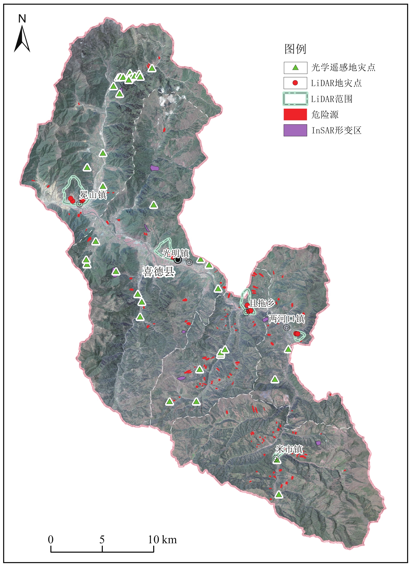
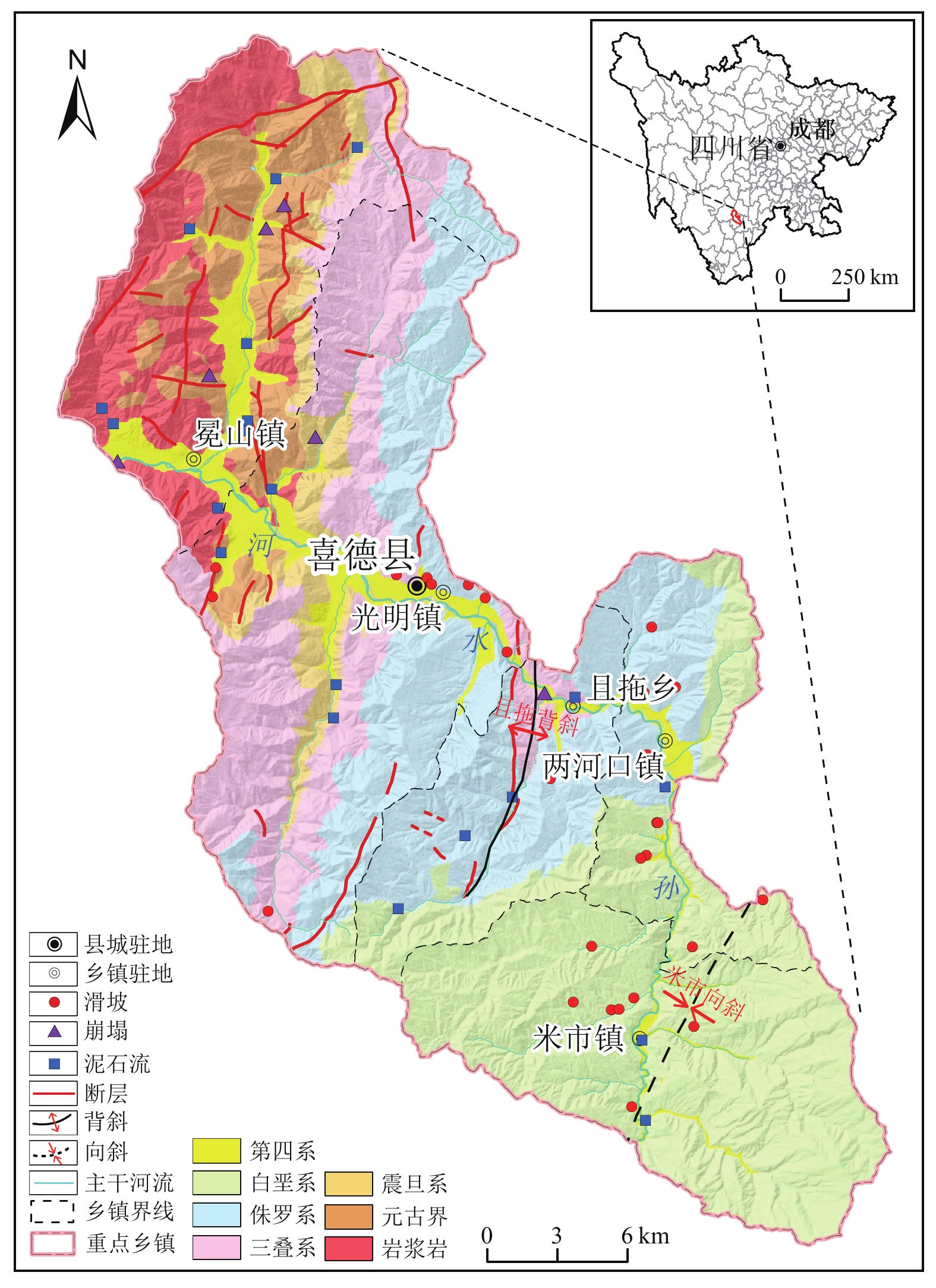
为了更好地适应山区城镇地质灾害隐患精细识别的需求,实现中、小型以及高隐蔽性地灾隐患的有效判识,本次以川西南喜德县重点乡镇为例,综合采用了光学遥感、InSAR、无人机载LiDAR、地面精细调查、高密度电法等方法,从不同精度和角度对研究区系统开展了地质灾害隐患判识。结果表明,不同手段具有很好的互补性,综合识别效果较好,共识别地灾隐患80处,包括新增识别29处,此外,识别潜在危险源131处;孕灾条件差异制约着不同识别方法的有效性,其中光学遥感在研究区西北部构造变形强烈、坚硬岩组分布区具有更好的识别效果,无人机摄影测量配合地面斜坡详查及物探探查等手段更适合东部米市宽缓向斜红层分布区的地灾识别,机载LiDAR高清三维摄影对重点城镇后山斜坡普遍发育的“簸箕形”平面形态滑坡和“栎叶状”流域平面形态泥石流识别效果较好;易崩易滑工程地质岩组与顺向型斜坡结构的优势组合是研究区地灾孕育的关键,而深部物探对控灾结构面探查是地质灾害隐患判识的重要佐证。
Abstract:In order to better meet the needs of geohazard identification in mountainous towns and effectively detect small-sized, medium-sized, and hidden geohazards, a case study was conducted in several typical towns in Xide County, southwest Sichuan. The study employed a comprehensive suite of techniques, including optical remote sensing, InSAR, LiDAR, detailed slope investigation, and high-density resistivity methods, to identify geohazards from various perspectives and levels of precision. The results show that these methods complement each other well and are effective in geohazard identification. A total of 80 occurrences of geohazards were identified, including 29 new identifications, along with 131 potential geohazard dangers. The differences in disaster-inducing factors in the study area constrain the effectiveness of different methods. Optical remote sensing proved more effective in areas characterized by strong structural deformation and hard rock formations. In contrast, unmanned aerial vehicle (UAV) photogrammetry, combined with detailed ground surveys and geophysical exploration, was more suitable for identifying geohazards in the red layer distribution areas of the Mishi wide gentle syncline. Airborne LiDAR high-definition 3D photography was particularly effective for identifying "dustpan-shaped" landslides and "oak leaf-shaped" debris flows, which are common on the slopes of key towns. The combination of easily collapsible and slidable engineering geological rock groups and dip-slope structures is the key to the formation of geohazards in the study area. Geophysical exploration targeting disaster-controlling structures is an important support for geohazard identification.
-

-
表 1 地质灾害及隐患综合遥感识别统计表
Table 1. Comprehensive remote sensing identification of geohazards and their interpretation signs
地质灾害及
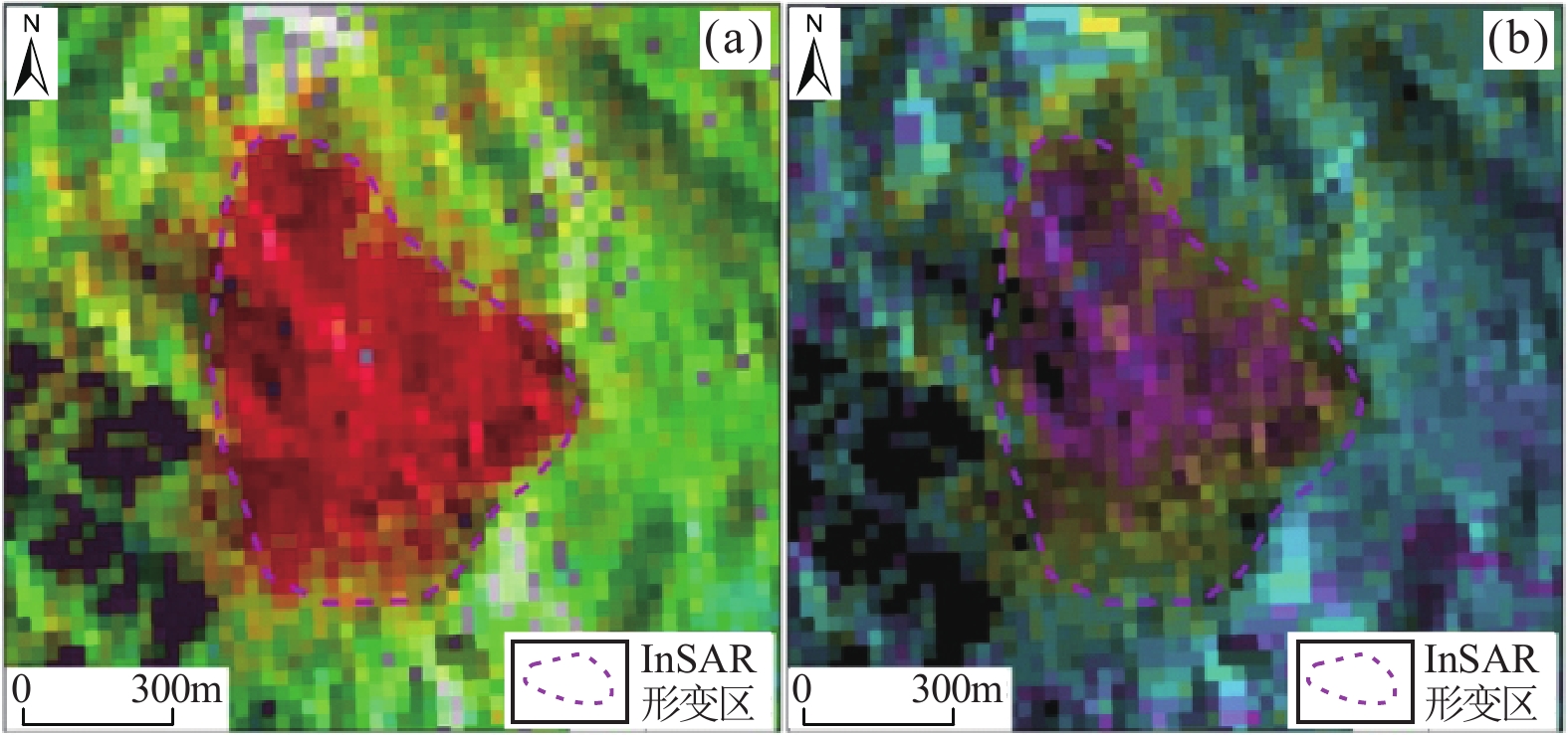
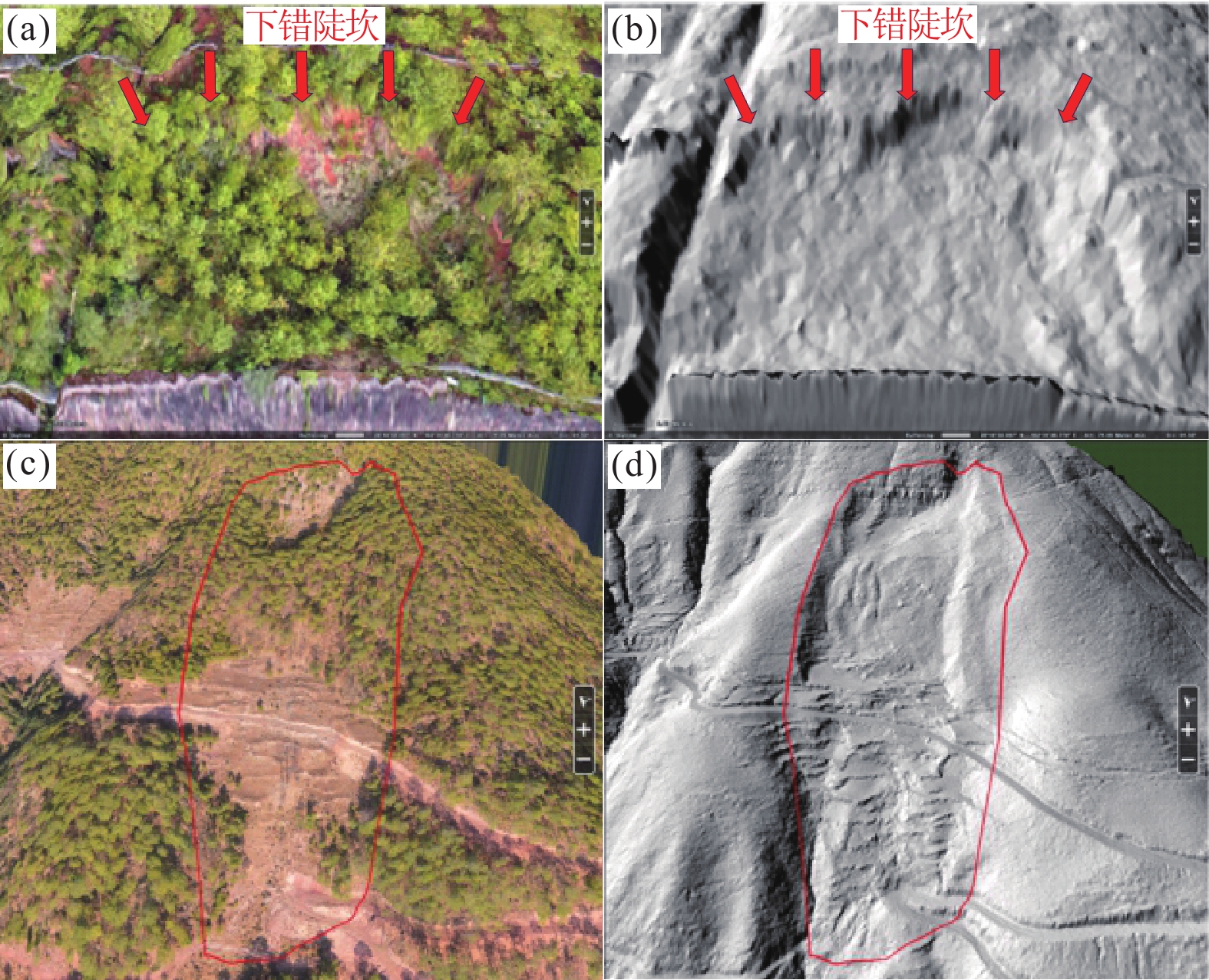
隐患类型识别方法 识别数量/处 主要识别标志 辅助识别标志 滑坡 光学遥感 10 地表地形破碎,周界清晰,
可见下错台坎等。坡面冲沟发育,植被分布差异等。 InSAR 1 “煎蛋状”环形形变干涉图,自外环往内变形增强等。 LiDAR 12 “簸箕形”平面形态,
滑坡壁、滑坡台阶、滑坡舌、滑坡裂缝、滑坡鼓丘等地形。不平整的坡体特征,后缘陡坎植被稀疏,地表裸露等。 崩塌 光学遥感 7 浅色调倒锥状碎石堆积体,
陡坎地形等。岩浆岩及碳酸盐岩等坚硬岩组分布区,前缘开挖等人类活动强烈等。 InSAR 1 单一型形变干涉图,图斑
颜色变化较为单一等。LiDAR 0 泥石流 光学遥感 22 栎叶形、瓢形、桃叶形沟
谷地貌,谷坡松散物源分布,沟口扇状地貌等。堆积扇呈套叠现象,谷坡植被
破坏,谷坡区大量修建消防通道的路渣等。InSAR 0 LiDAR 3 “栎叶状”流域形态,沟道及其两侧斜坡发育崩滑物源和沟道物源,沟口扇状地貌等。 沟床内流水冲刷,块石裸露,
零星灌木发育等。 下载: 导出CSV
-
[1] 党杰,董吉,何松标,等,2022. 机载LiDAR与地面三维激光扫描在贵州水城独家寨崩塌地质灾害风险调查中的应用[J]. 中国地质灾害与防治学报,33(4):106 − 113.
Dang J,Dong J,He S B,et al.,2022. Application of airborne LiDAR and ground 3D laser scanning in geological hazard risk investigation of Dujiazhai collapse in Shuicheng,Guizhou[J]. The Chinese Journal of Geological Hazard and Control,33(4):106 − 113 (in Chinese with English abstract).
[2] Francesca B,Ivan C,Paolo M,et al.,2011. Displacement patterns of a landslide affected by human activities:Insights from ground-based InSAR monitoring[J]. Natural Hazards,59:1377 − 1396. doi: 10.1007/s11069-011-9840-6
[3] 葛大庆,戴可人,郭兆成,等,2019. 重大地质灾害隐患早期识别中综合遥感应用的思考与建议[J]. 武汉大学学报:信息科学版,44(7):949 − 956.
Ge D Q,Dai K R,Guo Z C,et al.,2019. Early identification of serious geological hazards with integrated remote sensing technologies:Thoughts and recommendations[J]. Geomatics and Information Science of Wuhan University,44(7):949 − 956 (in Chinese with English abstract).
[4] 黄海峰,薛蓉花,赵蓓蓓,等,2022. 孕灾机理与综合遥感结合的三峡库首顺层岩质滑坡隐患识别[J]. 测绘学报,51(10):2056 − 2068.
Huang H F,Xue R H,Zhao B B,et al.,2022. The bedding rock landslide identification in the head area of the Three Gorges Reservoir combined with disaster pregnant mechanism and comprehensive remote sensing method[J]. Acta Geodaetica et Cartographica Sinica,51(10):2056 − 2068 (in Chinese with English abstract).
[5] 贾虎军,王立娟,范冬丽,2021. 无人机载LiDAR和倾斜摄影技术在地质灾害隐患早期识别中的应用[J]. 中国地质灾害与防治学报,32(2):60 − 65.
Jia H J,Wang L J,Fan D L,2021. The application of UAV LiDAR and tilt photography in the early identification of geo-hazards[J]. The Chinese Journal of Geological Hazard and Control,32(2):60 − 65 (in Chinese with English abstract).
[6] 蒋全科,雷宛,刘俊骐,2023. 利用高密度电法勘探盐边县格萨拉巨型滑坡堆积体[J]. 科学技术与工程,23(5):1853 − 1866.
Jiang Q K,Lei W,Liu J Q,2023. Exploration of Gesala giant landslide accumulation in Yanbian County by high-density electrical method[J]. Science Technology and Engineering,23(5):1853 − 1866 (in Chinese with English abstract).
[7] 刘星洪,姚鑫,於开炳,等,2020. 川藏高速巴塘−芒康段地质灾害遥感综合早期识别研究[J]. 四川大学学报(工程科学版),52(6):49 − 60.
Liu X H,Yao X,Yu K B,et al.,2020. Remote sensing integrated identification of geological hazards in the Batang- Mangkang section of the Sichuan-Tibet highway[J]. Advanced Engineering Sciences,52(6):49 − 60 (in Chinese with English abstract).
[8] Nicola C,William F,Stefano M,et al.,2017. Spaceborne,UAV and ground-based remote sensing techniques for landslide mapping,monitoring and early warning[J]. Geoenvironmental Disasters,4(1):1 − 23. doi: 10.1186/s40677-016-0065-6
[9] Scaioni M,Longoni L,Melillo V,et al.,2014. Remote Sensing for Landslide Investigations:An Overview of Recent Achievements and Perspectives[J]. Remote Sensing,6(12):9600 − 9652.
[10] 覃建雄,夏竹,张长俊,等,2001. 西昌复合盆地层序充填序列与沉积动力演化初探[J]. 古地理学报, 3(4):45 − 55.
Qin J X,Xia Z,Zhang C J,et al.,2001. Sequence filling succession and sedimentary dynamic evolution of the Xichang Compound Basin[J]. Journal of Palaeogeography, 3(4):45 − 55 (in Chinese with English abstract).
[11] 谭德军,尹晨沣,2020. 高植被覆盖复杂山区机载激光LiDAR点云分类与处理[J]. 地球科学前沿,10(7):616 − 621. doi: 10.12677/AG.2020.107060
Tan D J,Yin C P,2020. Classification and processing of airborne laser LiDAR point clouds in complex mountainous areas with high vegetation cover[J]. Advances in Geosciences,10(7):616 − 621 (in Chinese with English abstract). doi: 10.12677/AG.2020.107060
[12] 王家柱,高延超,铁永波,等,2023. 基于斜坡单元的山区城镇滑坡灾害易发性评价:以康定为例[J]. 沉积与特提斯地质, 43(3):640 − 650.
Wang J Z,Gao Y C,Tie Y B,et al.,2023. Landslide susceptibility assessment based on slope units of mountainous cities and towns:A case study of Kangding city[J]. Sedimentary Geology and Tethyan Geology, 43(3):640 − 650 (in Chinese with English abstract).
[13] 王运生,李云岗,1996. 西昌盆地的形成与演化[J]. 成都理工学院学报,1996,23(1):85 − 90.
Wang Y S,Li Y G,1996. Formation and evolution of the Xichang Basin[J]. Journal of Chengdu Institute of Technology,23(1):85 − 90 (in Chinese with English abstract).
[14] 吴明堂,房云峰,卓冠晨,等,2023. 白鹤滩库区三家村库岸地质灾害隐患综合遥感识别[J]. 昆明理工大学学报:自然科学版,48(3):53 − 61.
Wu M T,Fang Y F,Zhuo G C,et al.,2023. Comprehensive remote sensing identification of potential geohazards in Sanjiacun reservoir bank of Baihetan[J]. Journal of Kunming University of Science and Technology(Natural Science),48(3):53 − 61 (in Chinese with English abstract).
[15] 许强,董秀军,朱星,等,2023. 基于实景三维的天−空-地−内滑坡协同观测[J]. 工程地质学报, 31(3):706 − 717.
Xu Q,Dong X J,Zhu X,et al.,2023. Landslide collaborative observation technology based on real scene 3D view from Space-Air-Ground-Interior perspective[J]. Journal of Engineering Geology, 31(3):706 − 717 (in Chinese with English abstract).
[16] 许强,郭晨,董秀军,2022. 地质灾害航空遥感技术应用现状及展望[J]. 测绘学报,51(10):2020 − 2033.
X Q,Guo C,Dong X J,2022. Application status and prospect of aerial remote sensing technology for geohazards[J]. Acta Geodaetica et Cartographica Sinica,51(10):2020 − 2033 (in Chinese with English abstract).
[17] 许强,2020. 对地质灾害隐患早期识别相关问题的认识与思考[J]. 武汉大学学报:信息科学版,45(11):1651 − 1659.
XU Q,2020. Understanding and consideration of related issues in early identification of potential geohazards[J]. Geomatics and Information Science of Wuhan University,45(11):1651 − 1659 (in Chinese with English abstract).
[18] 卓冠晨,戴可人,周福军,等,2022. 川藏交通廊道典型工点InSAR监测及几何畸变精细判识[J]. 地球科学,47(6):2031 − 2047.
Zhuo G C,Dai K R,Zhou F J,et al.,2022. Monitoring typical construction sites of Sichuan-Tibet traffic corridor by InSAR and intensive distortion analysis [J]. Earth Science, 47(6):2031 − 2047 (in Chinese with English abstract).
[19] 赵超英,刘晓杰,高杨,等,2022. 基于SAR/InSAR技术的雅鲁藏布江下游高位地质灾害早期识别[J]. 地质力学学报, 28(6):981 − 994.
Zhao C Y,Liu X J,Gao Y,et al.,2022. Early identification of high-elevation geohazards in the lower Yarlung Zangbo River based on the SAR/InSAR technology[J]. Journal of Geomechanics, 28(6):981 − 994 (in Chinese with English abstract).
[20] 赵聪,铁永波,梁京涛,2023. 基于机载LiDAR技术的泥石流物源侵蚀量定量评价研究[J]. 沉积与特提斯地质,43(4):808 − 816.
Zhao C,Tie Y B,Liang J T,2023. Quantitative evaluation of debris flow provenance erosion based on Airborne Lidar Technology[J]. Sedimentary Geology and Tethyan Geology,43(4):808 − 816 (in Chinese with English abstract).
-


图(10)
表(1)
计量
- 文章访问数: 418
- PDF下载数: 189
- 施引文献: 0