

-
摘要:
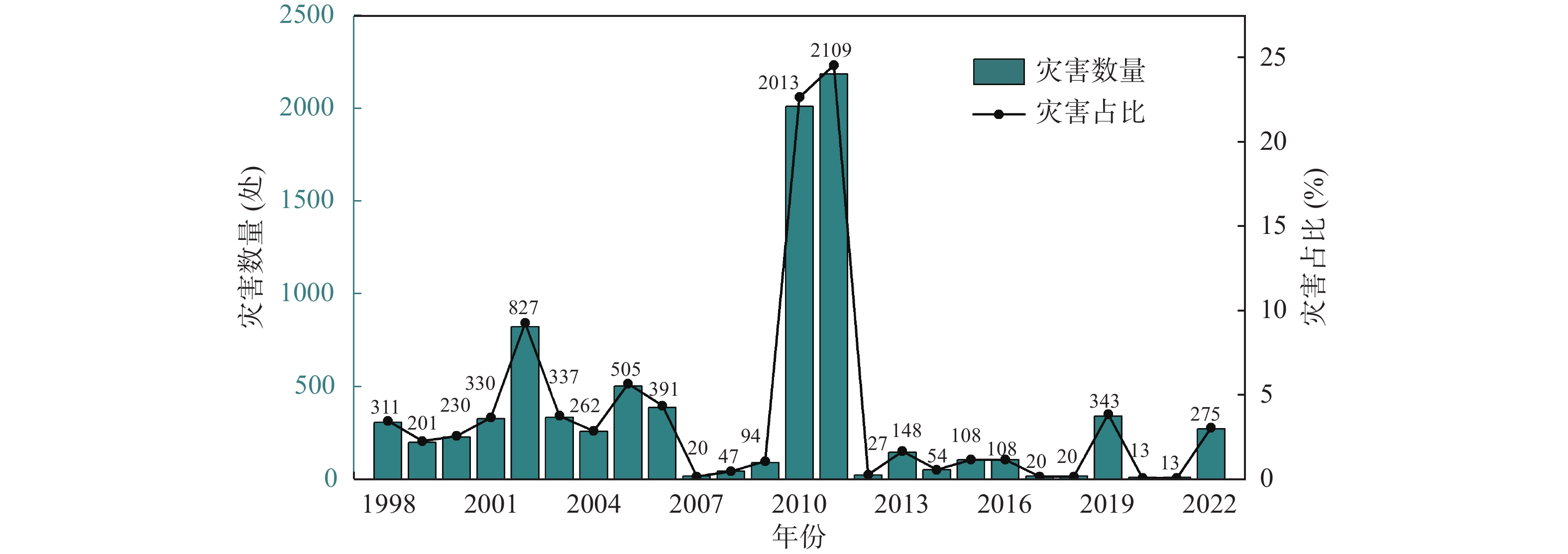
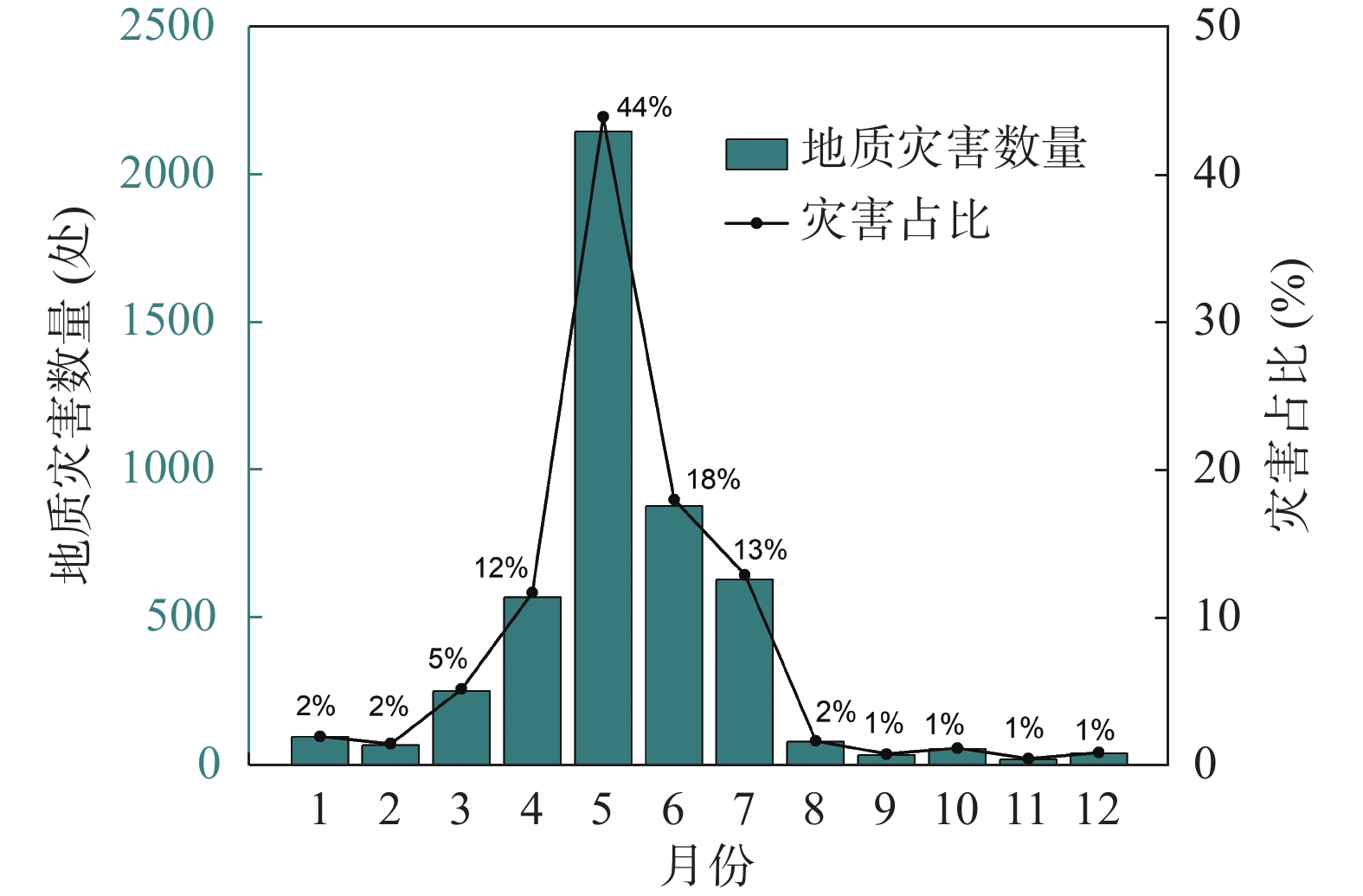
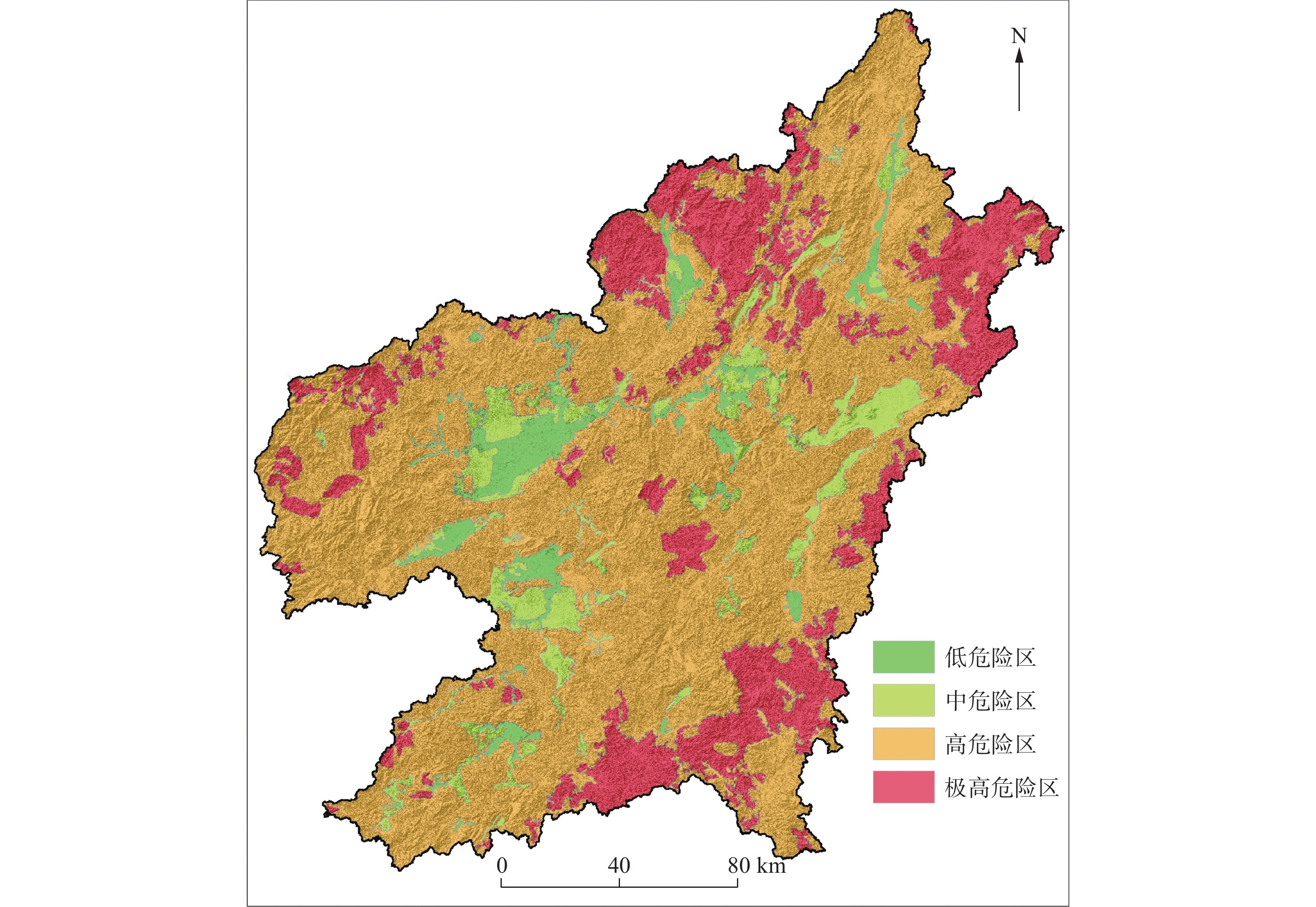
赣南地区山地丘陵地貌广泛分布,区内地质灾害高达10417处,严重威胁居民生命财产安全,因此,在该地区开展地质灾害风险评价对于预测、预报及防灾减灾具有重要意义。本文基于1︰5万地质灾害详查数据,分析了赣南地区的孕灾背景、灾害的发育分布特征及主控因素;在此基础上确定了坡度、斜坡结构、工程地质岩组、土层厚度、地貌单元及已发生灾害点密度六个易发性评价因子,并采用综合性指数法进行易发性评价。其次,开展20年一遇最大24小时降雨量及切坡诱发因素下研究区危险性评价,并叠加易损性分析对研究区开展风险评价。结果表明,研究区灾害以小型浅层流滑类型为主,主要发育于变质岩和岩浆岩残坡积层中,降雨及切坡活动是灾害发生的主控因素。赣南地区地质灾害极高风险、高风险、中风险、低风险区占比分别为0.8%、45.7%、40.3%和13.2%,其中,极高、高风险区主要分布于石城县、兴国县山区,而中低风险区主要分布在平原、丘陵等平缓地段。本文研究结果对该区域及类似区域的地质灾害风险防治与管控具有指导意义。
Abstract:The mountainous and hilly terrain of the southern Jiangxi (Gan Nan) region is widely distributed, with a total of 10,417 geological hazards, which pose a significant threat to the safety of lives and property. Therefore, conducting geological hazard risk assessments for this region is crucial for prediction, forecasting, and disaster reduction. This study, based on detailed geological hazard survey data at a 1∶50,000 scale, analyzes the disaster-prone background and distribution characteristics of geological hazards and the main control factors in southern Jiangxi. On this basis, six susceptibility evaluation factors were identified: slope, slope structure, engineering geological rock group, soil thickness, geomorphological units, and the density of previously occurred disaster points. A comprehensive index method was used for susceptibility assessment. Additionally, a hazard assessment was conducted for the study area, taking into account the 20-year return maximum 24-hour rainfall and slope-cutting-induced factors. The risk assessment was further refined by incorporating vulnerability analysis. The results show that the main types of disasters in the study area are small-scale shallow landslides and debris flows, which predominantly occur in metamorphic and igneous rock residual slope deposits, with rainfall and slope cutting activities being the dominant controlling factors. The proportions of the extremely high-risk, high-risk, medium-risk, and low-risk areas in southern Jiangxi are 0.8%, 45.7%, 40.3%, and 13.2%, respectively. The extremely high-risk and high-risk zones are mainly concentrated in the mountainous areas of Shicheng County and Xingguo County, while the medium-risk and low-risk zones are primarily found in the flat areas such as plains and hills. The findings of this study provide important guidance for the risk prevention and management of geological hazards in this region and similar geological environments.
-
Key words:
- geological hazard /
- risk assessment /
- control measure /
- southern Jiangxi province
-

-
表 1 易发性评价指标特征值及权重
Table 1. Characteristic values and weights of susceptibility evaluation indicators
因子 数据来源 指标分级 特征值(Ni) 权重(Ki) 地形坡度(°) 基于数字高程模型(DEM)提取 [0,15) 1 0.2 [15,25) 2 [25,35) 4 [35,45) 3 ≥45 2 斜坡结构类型 野外调查实测值结合以往区域地质调查数据 顺向坡 4 0.1 斜向坡 3 横向坡、平缓层状斜坡 2 逆向坡 1 块状斜坡 3 工程地质岩组 基于1∶5万地质图划分 坚硬的块状侵入岩岩组(Y1) 4 0.25 较坚硬、坚硬的块状火山熔岩,
火山碎屑熔岩岩组(Y2)2 较坚硬、坚硬的块状变粒岩组(B1) 2 较坚硬、坚硬的片状片岩岩组(B2) 3 较坚硬、坚硬的板岩、变碎屑岩、千枚岩岩组(B3) 4 较坚硬、坚硬的砂岩、砂砾岩、页岩岩组(S2) 2 软硬相间的含煤砂岩、页岩、泥岩岩组(S3) 3 软弱的、较坚硬的红层砂岩、
砂砾岩、泥岩岩组(S4)3 软弱的、较坚硬的页岩、砂岩、硅质岩岩组(S5) 2 软弱的砂岩、砾岩、泥岩岩组(S6) 3 坚硬的中等-强岩溶化灰岩、白云岩岩组(T1) 2 较坚硬、坚硬的中等岩溶化灰岩、
白云质灰岩、页岩岩组(T2)2 较坚硬、坚硬的弱岩溶化杂质灰岩、
砂岩、页岩岩组(T3)3 第四系残坡积层(N2) 2 土层(风化层)厚度(m) 利用野外调查
实测值进行插值<1 1 0.10 [1,3) 3 [3,5) 4 [5,10) 3 ≥10 2 地貌单元 基于数字高程模型(DEM)划分 平原 1 0.15 岗地 2 低丘陵 3 高丘陵 4 低山 4 中山 3 已发生灾点密度(点/km2) 基于历史灾情数据统计 <0.09 1 0.2 [0.09,0.31) 2 [0.31,0.72) 3 ≥0.72 4  下载: 导出CSV
表 2 评价因子分级特征值及权重
Table 2. Grading characteristic values and weights of evaluation factors
因子 分级 特征值(Ni/R) 权重(Ki) 20年一遇24 h最大降雨量(mm) [100,500) 1-4 - 切坡密度(m/km2) <100 1 0.3 [100,500) 2 [500, 1000 )3 ≥ 1000 4 易发性指数值 按实际取值 0.7
下载: 导出CSV
表 3 地质灾害风险评价矩阵分析表
Table 3. geological hazard risk assessment
易损性 危险性(风险等级) 极高 高 中 低 极高 极高 极高 高 中 高 极高 高 中 中 中 高 高 中 低 低 高 中 低 低
下载: 导出CSV
-
[1] 胡 鹏,王念秦,宋贵昌,赵世龙,乔丁丁,郝 业.2024.山区切坡活动引发地质灾害风险评估及其防控措施[J]. 灾害学,39(1):164-171. doi: 10.3969/j.issn.1000-811X.2024.01.026
[2] 贾丽娜,陈世昌.2024.基于AHP和GIS的舟曲地质灾害易发性评价[J]. 西北地质,57(1):23-33. doi: 10.12401/j.nwg.2023094
[3] 江西省地质矿产勘查开发局. 2017. 中国区域地质志•江西志[M]. 北京:地质出版社.
[4] 李春燕,孟 晖,张若琳,李亚民.2017.中国县域单元地质灾害风险评估[J]. 水文地质工程地质,44(2):160-166.
[5] 刘 帅,朱杰勇,杨得虎,马 博.2024.不同降雨工况条件下的崩滑地质灾害危险性评价[J]. 地质科技通报,43(2):253-267.
[6] 卢全中,彭建兵,赵法锁.2003.地质灾害风险评估(价)研究综述[J]. 灾害学,18(4):60-64. doi: 10.3969/j.issn.1000-811X.2003.04.012
[7] 罗永明,杜成江,黄 鹏,郭乐龙.2024.桂东县切坡建房引发的地质灾害特征及防治对策[J]. 资源信息与工程,39(3):96-99. doi: 10.3969/j.issn.2095-5391.2024.03.022
[8] 马寅生,张业成,张春山,王金山.2004.地质灾害风险评价的理论与方法[J]. 地质力学学报,10(1):7-18. doi: 10.3969/j.issn.1006-6616.2004.01.002
[9] 齐 信,唐 川,陈州丰,邵长生.2012.地质灾害风险评价研究[J]. 自然灾害学报,21(5):33-40.
[10] 丘嘉荣,黄利兵,王金秋.2024.不同降雨工况条件下东江上游城镇崩滑灾害危险性评价——以广东省龙川县四都镇为例[J]. 华南地质,40(4):773-782.
[11] 唐 川,马国超.2015.基于地貌单元的小区域地质灾害易发性分区方法研究[J]. 地理科学,35(1):91-98.
[12] 吴丹瑞,吴安琪,何新玥,李 明.2017.赣南地区近58年来极端气候变化趋势分析[J]. 长江科学院院报,34(1):24-29+39. doi: 10.11988/ckyyb.20150809
[13] 翟文华,王小东,吴明堂,吴晓亮,李倩倩.2023.基于频率比模型和随机森林模型耦合的地质灾害易发性评价[J]. 自然灾害学报,32(6):74-82.
[14] 张春山,吴满路,张业成.2003.地质灾害风险评价方法及展望[J]. 自然灾害学报,12(1):96-102. doi: 10.3969/j.issn.1004-4574.2003.01.016
[15] 张宏伟.2021.基于GIS的不同降雨工况下地质灾害危险性评价[J]. 华北自然资源,(4):103-105.
[16] 张茂省,薛 强,贾 俊,徐继维,高 波,王佳运.2019.山区城镇地质灾害调查与风险评价方法及实践[J]. 西北地质,52(2):125-135.
[17] 张平平,何 书,李 滨.2024.江西丘陵山区公路地质灾害危险性评价多耦合模型对比研究[J]. 中国地质灾害与防治学报,35(4):135-145.
[18] 张以晨,郎秋玲,陈亚南,张继权,田书文.2020.基于自然灾害风险评价框架的省级地质灾害风险区划方法探讨——以吉林省为例[J]. 中国地质灾害与防治学报,31(6):104-110.
[19] Sun X P, Zeng P, Li T B, Zhang T L, Feng X D, Jimenez R. 2021. Run-out distance exceedance probability evaluation and hazard zoning of an individual landslide[J]. Landslides, 18(4): 1295-1308. doi: 10.1007/s10346-020-01545-w
[20] Xu C, Dai F C, Xu X W, Lee Y H. 2012. GIS-based support vector machine modeling of earthquake-triggered landslide susceptibility in the Jianjiang River watershed, China[J]. Geomorphology, 145-146: 70-80. doi: 10.1016/j.geomorph.2011.12.040
[21] Xu S H, Zhang M, Ma Y, Liu J P, Wang Y, Ma X R, Chen J. 2021. Multiclassification method of landslide risk assessment in consideration of disaster levels: a case study of Xianyang City, Shaanxi Province[J]. ISPRS International Journal of Geo-Information, 10(10): 646. doi: 10.3390/ijgi10100646
-


图(10)
表(3)
计量
- 文章访问数: 95
- PDF下载数: 7
- 施引文献: 0