APPLICATION METHODS OF OVERSEA MULTI-SOURCE GEOLOGICAL THEMATIC MAP DATA
-
摘要:
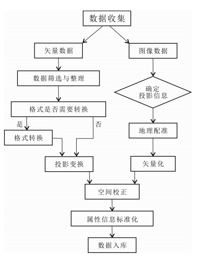
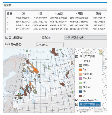
境外多源地质专题图数据源,主要是来自公开出版物购买、网站下载以及国际合作交流时收集到的地质专题图件.通过利用ArcGIS软件,按照中国地质调查局编制的《全球地质矿产数据库建设指南》要求,应用数据库技术将境外多源地质专题图数据进行有效的管理和应用.本文就利用ArcGIS软件,对境外多源地质专题图数据应用中的数据格式转换、地图投影、地理配准、空间校正等几个关键问题进行了探讨和研究.
Abstract:The source data of oversea multi-source geological thematic maps are mainly collected from public purchases, websites or international exchanges. According to the Guide of the Global Geological and Mineral Resources Database Construction compiled by the China Geological Survey, database technology with ArcGIS software is used to effectively manage and apply overseas multi-source geological map data. In this paper, several key issues such as data format conversion, map projection, geographic registration and spatial correction in the application of multi-source geological thematic map data are discussed and research.
-

-
表 1 常用投影方法的特点
Table 1. Characteristics of common projection methods
投影类型 特点 圆锥投影 经纬线正交,经线呈现放射形,纬线为同心圆 等角圆锥投影:沿经线方向,纬线间隔从地图中心向南、北方向逐渐扩大 等积圆锥投影:沿经线方向,纬线间隔从地图中心向南、北方向逐渐缩小 等距圆锥投影:沿经线方向,所有圆形纬线的间距相等 圆柱投影 高斯-克吕格投影:除中央子午线外经线呈弧形,赤道和中央子午线垂直 墨卡托投影:经线彼此平行且间距相等; 纬线彼此平行,但离极点越近,其间距越大 表 2 成矿省面元属性结构表
Table 2. Attribute structure of metallogenic province
字段名称 字段类型 字段长度 小数位数 约束条件 ID L 8 必选 面积 D 15 6 必选 周长 D 15 6 必选 成矿省名称 C 50 必选 构造特征 C 100 必选 主要矿床 C 30 必选 备注 C 254 可选 注:以成矿省面元属性结构为例. -
[1] 王杨刚, 李玉龙, 周丙锋, 等.境外地质矿产信息集成和服务平台建设实践与思考[J].中国矿业, 2014, 23(S2):327-333. http://d.old.wanfangdata.com.cn/Periodical/zgky2014z2079
[2] 王杨刚, 李娜, 向运川, 等.全球地质矿产数据建库方法技术研究[J].中国地质, 2015, 42(1):342-353. http://d.old.wanfangdata.com.cn/Periodical/zgdizhi2015010028
[3] 何学洲, 向运川, 王杨刚, 等.全球地质矿产数据库质量控制体系建立与应用[J].中国地质, 2015, 42(2):737-744. http://d.old.wanfangdata.com.cn/Periodical/zgdizhi201502030
[4] 靖娟利, 王永锋.一种MapGIS到ArcGIS数据转换方法[J].工程勘察, 2013, 41(7):50-52, 62. http://d.old.wanfangdata.com.cn/Periodical/gckc201307011
[5] 黄云. MapGIS向ArcGIS数据格式转换方法探讨[J].地矿测绘, 2010, 26(1):33-35. http://d.old.wanfangdata.com.cn/Periodical/dkch201001011
[6] 杨冰玉, 艾力. AutoCAD数据到ArcGIS数据转换方法的研究[J].国土资源导刊, 2019, 16(2):72-74. http://d.old.wanfangdata.com.cn/Periodical/hunandz201902017
[7] 刘宏林, 吕晓华, 安敏.透视圆锥投影的研究[J].测绘学院学报, 2001, 18(4):300-302, 306. http://d.old.wanfangdata.com.cn/Periodical/chxyxb200104019
[8] 赵春子.地图投影的判别方法与选择依据[J].延边大学学报(自然科学版), 2013, 39(4):311-314. http://d.old.wanfangdata.com.cn/Periodical/ybdxxb-zrkxb201304019
[9] 樊敏, 秦健, 李云响, 等. ArcGIS数字化地质图校正及配准[J].化工矿产地质, 2014, 36(3):185-189. http://d.old.wanfangdata.com.cn/Periodical/hgkcdz201403009
-


 下载:
下载:


