

APPLICATION OF GRAY EVALUATION METHOD IN ENGINEERING CONSTRUCTION SUITABILITY EVALUATION BASED ON GIS AND AHP: A Case Study of the Downtown Huangshan City
-
摘要:
随着城市现代化进程的加快,工程建设活动日趋频繁.在城市规划、工程建设前进行地质条件分析、适宜性评价是十分必要的.工程建设适宜性受多种因素影响,各因素间相互关联但影响程度不同.文章以黄山市中心城区为实例,从地质环境条件角度出发,介绍基于地理信息系统(GIS)和层次分析法(AHP)的灰色评估法在实际评价工作中的具体应用.该方法首先选取与工程建设适宜性密切相关的影响因素作为评价因子,在对评价单因子定性评价的基础上,用AHP确定各评价单因子的权重,最后用灰色评估法对工程建设适宜性进行综合评估.该应用效果较好,可在同类评价中推广.
Abstract:With the acceleration of urban modernization, engineering activities are becoming increasingly frequent. It is necessary to analyze the geological conditions and evaluate suitability before urban planning and engineering construction. The suitability of engineering construction is affected by multiple interrelated factors in different degrees. Taking the downtown Huangshan City for example, the paper introduces the application of GIS- and AHP-based grey evaluation method in suitability evaluation from the perspective of geoenvironment. The method first selects the influencing factors closely related to the suitability as evaluation factors, then determines the weight by AHP on the basis of the qualitative evaluation on single factor, and finally evaluates the suitability comprehensively with the grey evaluation method. The effect proves to be good, which can be extended to the same kind of evaluations.
-
Key words:
- engineering construction /
- GIS /
- AHP /
- gray evaluation /
- suitability evaluation /
- geoenvironment /
- Huangshan City
-

-
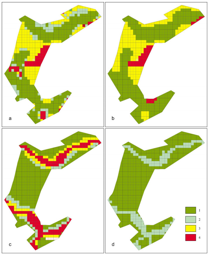
表 1 黄山市中心城区工程建设适宜性评价因子及评分标准
Table 1. Suitability evaluation factors and scoring criteria for engineering construction in the downtown Huangshan City
评价因丁 分值 0 < wi ≤1.00 1.00 < wi ≤2.00 2.00 < wi ≤3.00 3.00 < wi ≤4.00 地形地貌(w1) 地面坡度≥50° 25。≤地面坡度 < 50° 10。 < 地面坡度 < 25° 地面坡度≤10° 地质灾害(w2) 高易发区 中易发区 低易发区 不易发区 水文条件(w3) 设防标高-地面标高≥1m 0.5 m≤设防标高-地面标高 < 1m 设防标高-地面标高 < 0.5 m 设防标高≤地面标高 工程地质(w4) 地基承载力 < 80kPa, 粧端持力层埋深 > 50 m 地基承载力80~150kPa, 30 m < 粧端持力层埋深≤50 m 地基承载力150~200 kPa, 5m < 粧端持力层埋深≤30 m 地基承载力≥200 kPa, 粧端持力层埋深 < 5 m  下载: 导出CSV
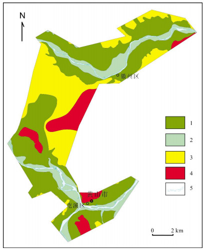
表 2 黄山市中心城区工程建设适宜性分区划分
Table 2. Suitability division of engineering construction in the downtown Huangshan City
质量等级 适宜区 较适宜区 适宜性一般区 适宜性差区 评估值 [1.00, 1.50] [1.50, 2.50] [2.50, 3.50] [3.50, 4.00]
下载: 导出CSV
表 3 评价因子判断矩阵及权重
Table 3. Judgment matrix and weight of evaluation factors
W1 W2 W3 W4 V 指标值 W1 1 1.5 2 1/1.2 0.3032 λmax=4.0205 W2 1/1.5 1 1.5 1/1.5 0.2179 CI=0.0068 W3 1/1.5 1/2 1 1/1.6 0.1638 RI=0.9 W4 1.2 1.5 1.6 1 0.3151 CR=0.0076
下载: 导出CSV
-
[1] 程惠红.曹妃甸滨海新区工程建设适宜性评价[D].北京: 中国地质大学, 2009.
http://cdmd.cnki.com.cn/Article/CDMD-11415-2009075617.htm [2] 张堃.基于GIS的山地城镇工程建设场地适宜性评价系统设计与开发研究[D].重庆: 重庆大学, 2016.
http://cdmd.cnki.com.cn/Article/CDMD-10611-1016908492.htm [3] 陈柳柳, 李振团, 张位华.贵安新区省直管区规划勘察工程建设适宜性评价[J].黑龙江交通科技, 2015(6):155-158. http://d.old.wanfangdata.com.cn/Periodical/hljjtkj201506130
[4] 杨晓龙.田市镇及周边地区工程地质环境质量评价与工程建设适宜性分析[D].西安: 长安大学, 2016.
http://cdmd.cnki.com.cn/Article/CDMD-10710-1016749820.htm [5] 唐辉明.地质环境与城市发展研究综述[J].工程地质学报, 2006, 14(6):729-732. http://d.old.wanfangdata.com.cn/Periodical/gcdzxb200606002
[6] 张丽君.国际城市地质工作的主要态势[J].国土资源情报, 2001(6):1-13. http://www.cqvip.com/QK/97514B/200106/1000001583.html
[7] 田婧, 韩秀丽.工程地质环境评价方法[J].河北理工学报, 2007, 29(1):125-128. http://d.old.wanfangdata.com.cn/Periodical/hblgxyxb200701031
[8] 孙建筑.基于GIS的石家庄市建设用地适宜性评价[D].天津: 河北工业大学, 2013.
http://cdmd.cnki.com.cn/Article/CDMD-10080-1014032148.htm [9] 赵焕臣, 许树柏, 和金生.层次分析法——一种简易的新决策方法[M].北京:科学出版社, 1986:103-121.
[10] 王辉, 祝文君.基于GIS的城市地下空间资源调查评估[J].地下空间与工程学报, 2006, 2(8):1308-1312. http://d.old.wanfangdata.com.cn/Periodical/dxkj2006z2006
[11] CJJ57-2012, 城乡规划工程地质勘查规范[S].北京: 中国建筑工业出版社, 2012.
-
图(3)
表(3)
计量
- 文章访问数: 419
- PDF下载数: 73
- 施引文献: 0