

EVALUATION ON THE GROUNDWATER RESOURCES IN RIVERSIDE EMERGENCY WATER SOURCE BASED ON GMS
-
摘要:
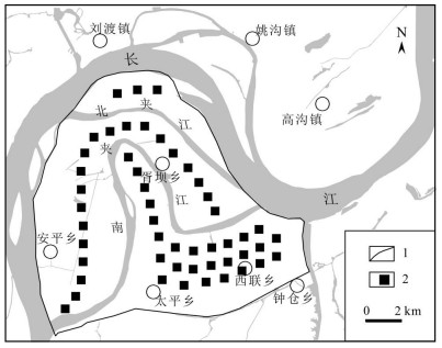
依据铜陵太平-钟仓应急水源地水文地质条件构建水文地质概念模型.在此基础上,利用三维可视化软件GMS建立水源地地下水流数值模拟模型,并对模型进行了识别和验证.模型模拟期为一个应急供水周期180 d(2017-01~2017-06),水源地开采层位为承压水.模拟结果表明:在采用均匀布井方案和限定开采井水位降深不超过承压含水层顶板的条件下,水源地允许开采量为11.94×10⁴ m3/d,达大型水源地规模(5×104 m3/d < 允许开采量 < 15×104 m3/d);水源地承压水在应急开采条件下,激发了长江侧渗补给量,袭夺量占水源地开采总量的27.82%.同时,通过模型模拟数据对傍河水源地地下水与地表水转换规律进行了初步探讨.
Abstract:The hydrogeological conceptual model is constructed according to the hydrogeological conditions of Taiping-Zhongcang emergency water source in Tongling City. On this basis, the numerical simulation model of groundwater flow is established by 3D visualization software GMS, and then identified and verified. The simulation period is an emergency water supply cycle of 180 days (Jan. through Jun., 2017) with confined groundwater as the mining layer. The results show that the allowable exploitation of water source is 11.94×10⁴ m3/d, which reaches large scale (5×10⁴-15×104 m3/d), under the condition of uniform distribution of wells, with mining well level drawdown not exceeding the roof of confined aquifer. Under the condition of emergency exploitation, the lateral seepage supply of Yangtze River is stimulated, accounting for 27.82% of the total water exploitation amount. The simulation data is also used for preliminary study of the conversion rules between ground and surface water.
-

-
表 1 水源地承压水开采条件下日均开采量组成分析表
Table 1. Composition analysis on average daily exploitation of the confined groundwater in water source
模型均衡项 天然状态下/(m3/d) 开采条件下/(m3/d) 开采量组成/(m3/d) 开采量组成占比/% 补给 潜水越流补给 3032.87 72419.75 69386.88 58.12 侧向流入 294.43 294.43 长江侧渗补给 0.00 26506.25 33220.21 27.82 排泄 向长江排泄 6713.96 0.00 水源地开采量 0.00 119400.00 总计 总补排差 -3386.60 -20179.67 储存量的变化量 -3386.60 -20179.67 16793.07 14.06  下载: 导出CSV
表 2 天然状态下水源地潜水、承压水与长江水三水相互转换量分析表
Table 2. Analysis on phreatic, confined groundwater of the water source and Yangtze River water conversion in natural state
地下水类型 转换项 1月 2月 3月 4月 5月 6月 潜水 向长江排泄 21663.49 20705.22 2124.04 长江侧渗补给 21367.88 10497.09 10706.87 承压水越流补给 6376.48 9543.92 10869.99 向承压水越流排泄 13772.02 19685.09 12390.02 承压水 向长江排泄 31215.42 35769.03 12237.60 长江侧渗补给 18510.19 9398.37 9556.48 潜水越流补给 13772.02 19685.09 12390.02 向潜水越流排泄 6376.48 9543.92 10869.99 单位:m3/d.
下载: 导出CSV
表 3 开采状态下水源地潜水、承压水与长江水三水相互转换量分析表
Table 3. Analysis on phreatic, confined groundwater of the water source and Yangtze River water conversion in mining state
地下水类型 转换项 1月 2月 3月 4月 5月 6月 潜水 向长江排泄 20820.46 19119.78 74.05 长江侧渗补给 23497.43 12677.61 12863.35 承压水越流补给 向承压水越流排泄 67976.02 85500.85 83100.96 67016.65 65830.26 65977.60 承压水 向长江排泄 9013.22 5811.26 长江侧渗补给 21984.86 55074.02 47254.10 48037.58 潜水越流补给 67976.02 85500.85 83100.96 67016.65 65830.26 65977.60 向潜水越流排泄 单位:m3/d.
下载: 导出CSV
-
[1] 朱学愚, 钱孝星.中国东部若干城市地下水资源的合理开发与保护[J].水利学报, 1997(11):20-27. doi: 10.3321/j.issn:0559-9350.1997.11.003
[2] 邵景力, 崔亚莉, 赵云章, 等.黄河下游影响带(河南段)三维地下水流数值模拟模型及其应用[J].吉林大学学报:地球科学版, 2003, 33(1):51-55. http://d.old.wanfangdata.com.cn/Periodical/cckjdxxb200301010
[3] GU Lei-lei, SHAO-Jingli, SUN Yue, et al. Groundwater flow simulation and resource evaluation of the affected zone along the Yellow River (Henan section)[J]. Advanced Materials Research:Progress in Environmental Science and Engineering, 2013, 610-613:2713-2718. https://www.scientific.net/AMR.610-613.2713
[4] 秦学林.傍河取水型水源地河水诱导补给量计算方法探讨[J].电力勘测, 1995(4):8-14. http://www.cnki.com.cn/Article/CJFDTotal-DLKC199504001.htm
[5] 韩再生.傍河地下水水源地的若干问题[J].北京地质, 1997(3):33-35. http://www.wanfangdata.com.cn/details/detail.do?_type=perio&id=QK199600097641
[6] 刘国东.傍河地下水与河水脱节机理研究[J].长春科技大学学报, 1998, 28(1):64~69. http://www.wanfangdata.com.cn/details/detail.do?_type=perio&id=QK199800205226
[7] 钱会, 郑西来, 樊秀峰.傍河取水越河稳定渗流问题的三维数值模拟研究[J].水利学报, 1999(3):32-37. doi: 10.3321/j.issn:0559-9350.1999.03.006
[8] 贾秀梅, 孙继朝, 臧逸中.汾河口傍河水源地激发补给量研究[J].地理与地理信息科学, 2003, 19(5):105-108. doi: 10.3969/j.issn.1672-0504.2003.05.025
[9] 刘国东, 丁晶.傍河水源地地下水资源评价方法述评[J].水科学进展, 1998, 9(3):289-295. doi: 10.3321/j.issn:1001-6791.1998.03.014
[10] 易树平, 迟宝明, 吴法伟, 等.傍河地下水源地数值模拟与评价研究[J].自然资源学报, 2006, 21(1):154-160. doi: 10.3321/j.issn:1000-3037.2006.01.020
[11] 田辉, 郭晓东, 刘强, 等.大庆市地下水开采现状及环境问题探讨[J].地质与资源, 2012, 21(1):139-142. doi: 10.3969/j.issn.1671-1947.2012.01.021
[12] 缪晓宇, 郭昂青.黑龙江省松嫩平原地下水开发利用中主要问题及对策[J].地质与资源, 2010, 19(2):105-108. doi: 10.3969/j.issn.1671-1947.2010.02.005
[13] 邸志强, 苗英, 贾伟光, 等.东北地区水资源现状及可持续利用对策[J].地质与资源, 2004, 13(2):113-115. http://d.old.wanfangdata.com.cn/Periodical/gjsdz200402008
[14] 廖资生, 林学钰, 石钦周, 等.黄河下游悬河段傍河开采地下水的试验研究——以郑州市区黄河滩地为例[J].工程勘察, 2004(3):20-27. http://d.old.wanfangdata.com.cn/Periodical/gckc200403006
[15] 戴长雷, 迟宝明, 陈鸿雁.傍河型地下水水源地论证[J].工程勘察, 2005(2):26-28. http://d.old.wanfangdata.com.cn/Periodical/sw200802008
[16] 郑环.现代地下水资源数值模拟技术研究[J].节水灌溉, 2008(7):37-41. doi: 10.3969/j.issn.1007-4929.2008.07.012
[17] 邵景力, 赵宗壮, 崔亚莉, 等.华北平原地下水流模拟及地下水资源评价[J].资源科学, 2009, 31(3):361-367. doi: 10.3321/j.issn:1007-7588.2009.03.002
[18] 王婉丽, 杨广元, 王贵玲.浩勒报吉水源地地下水流数值模拟及开采引起的环境问题评价[J].南水北调与水利科技, 2010, 8(6):36-41. http://d.old.wanfangdata.com.cn/Periodical/nsbdyslkj201006010
[19] 陈枭萌, 徐嘉璐, 郭倩, 等.陕西省吴堡县岔上水源地地下水允许开采量评价[J].南水北调与水利科技, 2013, 11(5):22-26. http://d.old.wanfangdata.com.cn/Periodical/nsbdyslkj201305005
[20] 郑立博, 李阳, 王少龙, 等.某应急水源地地下水资源评价[J].地质灾害与环境保护, 2014, 25(3):83-87. doi: 10.3969/j.issn.1006-4362.2014.03.015
[21] 杨坡, 张文娟, 李自涛.河南新乡市傍河水源地浅层地下水资源评价[J].节水灌溉, 2015(10):67-70. doi: 10.3969/j.issn.1007-4929.2015.10.016
[22] 彭文, 陈思佳, 周世玲.福清平原地下水可采资源量及应急开采量评价[J].华东地质, 2017, 38(4):314-319. doi: 10.3969/j.issn.1674-3504.2017.04.003
[23] 何小亮, 刘潇敏, 王逸民.榆溪河流域水源地地下水资源评价数值模拟研究[J].地下水, 2017, 39(6):24-26. doi: 10.3969/j.issn.1004-1184.2017.06.007
[24] 赵建忠, 魏莉莉, 赵玉萍, 等.黑河流域地下水与地表水转化研究进展[J].西北地质, 2010, 43(3):121-126. http://d.old.wanfangdata.com.cn/Periodical/xbdz201003016
-
图(6)
表(3)
计量
- 文章访问数: 484
- PDF下载数: 65
- 施引文献: 0