

GEOMORPHOLOGY OF THE FUXIANHU DRAINAGE BASIN AND ITS STRUCTURAL IMPLICATION
-
摘要:
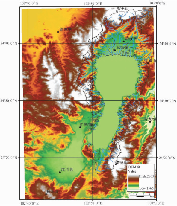
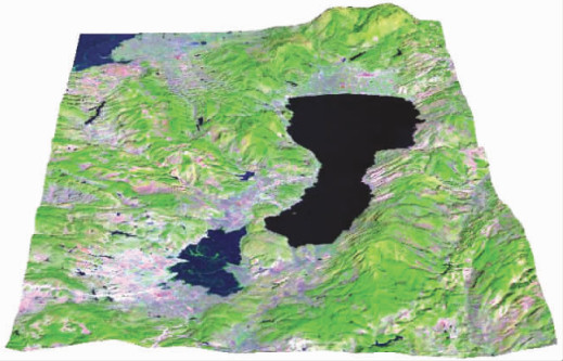
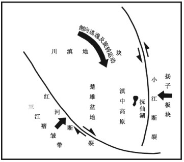
以数字高程模型数据为基础, 运用ArcGIS软件平台, 从数字高程模型数据中提取抚仙湖流域内相对独立的61个亚流域, 其中34个位于小江断裂东侧的山地中, 另外27个位于小江断裂西侧的山地中; 然后计算每一个流域单元流域的面积、周长、河流总长、形状指数、平均坡度、相对高差以及高程-面积积分值和水系分支比, 划分流域等级等。通过对流域地貌参数以及高程-面积积分值和分支比等的特征参数的详细分析, 初步表明抚仙湖两侧水系和亚流域的发育具有东西分异的特征。这些特征指示了抚仙湖水系两侧晚新生代构造活动的差异性, 反映了小江断裂带东西两侧的不均衡抬升。小江断裂带的活动控制了抚仙湖流域晚新生代快速隆起, 滇中高原快速隆起以及小江构造带内部差异活动是造成抚仙湖流域东西差异特征地貌的主要原因。
Abstract:We took adavage of ArcGIS software platform to obtain the data of geometrical shapes and boundaries of 61 sublevel individual watersheds in the Fuxianhu drainage With SRTM-DEM as the basic data, 34 in the ridges east to Xiaojiang fault, 27 in the ridges west to the Xiaojiang fault. Afterwards, we calculated the watershed areas, perimeters, river lengths, shape indexs, average slopes, relative height differences, elevation-area integral values, the drainage branching ratios and the level of the 61 watersheds. The results show some differences between the east and west ridges. These features indicates the difference in Late Cenozoic tectonic activity on both sides of the Fuxianhu drainage and reflects the uneven uplift on east and west sides of the Xiaojiang fault zone. The activity of the Xiaojiang fault zone imposed a control over the rapid uplift of the Fuxianhu drainage during the Late Cenozoic basin, and the rapid uplift of the Central Yunnan Plateau and the difference in activity of interior of the Xiaojiang fault zone are the leading factors causing the different topographies on east and west sides of the Fuxian drainage.
-

-
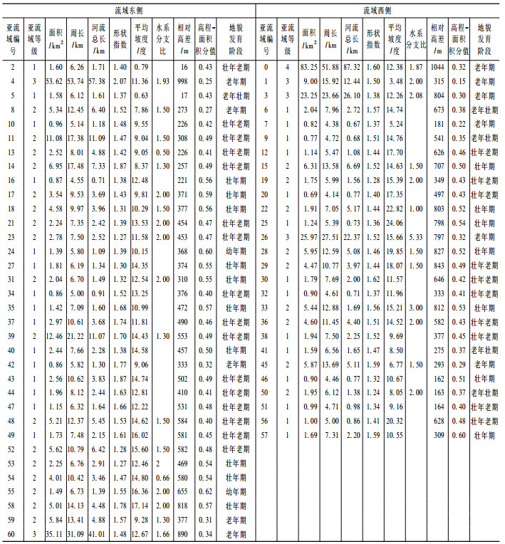
表 1 抚仙湖流域亚盆地主要特征参数
Table 1. Characteristics of the sub-basins in the Fuxianhu drainage basin
 下载: 导出CSV
-
[1] 廖义善, 蔡强国, 秦奋, 等.基于DEM黄土丘陵沟壑区不同尺度流域地貌现状及侵蚀产沙趋势[J].山地学报, 2008, 26 (3):347~355. doi: 10.3969/j.issn.1008-2786.2008.03.016
LIAO Yishan, CAI Qiangguo, QIN Fen, et al. Study on topographic evolution and the eroding trend in hilly loess areas, North China[J]. Journal of Mountain Science, 2008, 26 (3):347~355. doi: 10.3969/j.issn.1008-2786.2008.03.016
[2] Summer field M A. Geomorphology and Global Tectonics[M]. London:John Wiley & Sons, Ltd Press, 2000, 1~143.
[3] 张思科, 倪晋宇, 高万里, 等.三维地质建模技术方法研究-以东昆仑造山带为例[J].地质力学学报, 2009, 15 (2):201~208. doi: 10.3969/j.issn.1006-6616.2009.02.009 http://journal.geomech.ac.cn/ch/reader/view_abstract.aspx?flag=1&file_no=20090209&journal_id=dzlxxb
ZHANG Sike, NI Jinyu, GAO Wanli, et al. Study on the technology and method of 3-D geological modeling:A case study of the east Kunlun orogenic belt[J]. Journal of Geomechanics, 2009, 15 (2):201~208. doi: 10.3969/j.issn.1006-6616.2009.02.009 http://journal.geomech.ac.cn/ch/reader/view_abstract.aspx?flag=1&file_no=20090209&journal_id=dzlxxb
[4] 刘玉涛.地球空间信息学与对地观测学在灾难管理中的应用研究进展[J].地质力学学报, 2008, 14 (3):212 ~220. doi: 10.3969/j.issn.1006-6616.2008.03.003 http://journal.geomech.ac.cn/ch/reader/view_abstract.aspx?flag=1&file_no=20080325&journal_id=dzlxxb
LIU Yutao. Geomatics and earth observation science (EOS) for disaster management:An overview[J]. Journal of Geomechanics, 2008, 14 (3):212~220. doi: 10.3969/j.issn.1006-6616.2008.03.003 http://journal.geomech.ac.cn/ch/reader/view_abstract.aspx?flag=1&file_no=20080325&journal_id=dzlxxb
[5] 郭芳芳, 杨农, 张岳桥, 等.基于GIS的滑坡地质灾害地貌因素分析[J].地质力学学报, 2008, 14 (1):87~ 96. doi: 10.3969/j.issn.1006-6616.2008.01.008 http://journal.geomech.ac.cn/ch/reader/view_abstract.aspx?flag=1&file_no=20080108&journal_id=dzlxxb
GUO Fangfang, YANG Nong, ZHANG Yueqiao, et al. GIS-based analysis of geomorphological factors for landslide hazards [J]. Journal of Geomechanics, 2008, 14 (1):87~96. doi: 10.3969/j.issn.1006-6616.2008.01.008 http://journal.geomech.ac.cn/ch/reader/view_abstract.aspx?flag=1&file_no=20080108&journal_id=dzlxxb
[6] Michael A. Geomorphology and Global Tectonics[M]. London:John Wiley & Sons, Ltd Press, 2000.
[7] Burbank D W, Anderson R S. Tectonic Geomorphology[M]. Massachusetts:Blackwell Science, 2002, 1~274.
[8] 付碧宏, 张松林, 谢小平, 等.阿尔金断裂系西段-康西瓦断裂的晚第四纪构造地貌特征研究[J].第四纪研究, 2006, 26 (2):228~235. doi: 10.3321/j.issn:1001-7410.2006.02.010
FU Bihong, ZHANG Songlin, XIE Xiaoping, et al. Late Quaternary tecton-geomorphic features along the Kangxiwar fault, Altyn Tagh fault system, northern Tibet[J]. Quaternary Sciences, 2006, 26 (2):228~235. doi: 10.3321/j.issn:1001-7410.2006.02.010
[9] 张会平, 杨农, 张岳桥, 等.岷江水系流域地貌特征及其构造指示意义[J].第四纪研究, 2006, 26 (1):126 ~135. doi: 10.3321/j.issn:1001-7410.2006.01.016
ZHANG Huiping, YANG Nong, ZHANG Yueqiao, et al. Geomorphology of the Minjiang drainage system (Sichuan, China) and its structural implications[J]. Quaternary Sciences, 2006, 26 (1):126~135. doi: 10.3321/j.issn:1001-7410.2006.01.016
[10] 李新坡, 莫多闻, 朱忠礼.侯马盆地冲积扇及其流域地貌发育规律[J].地理学报, 2006, 61 (3):241~248. doi: 10.3321/j.issn:0375-5444.2006.03.002
LI Xinpo, MO Duowen, ZHU Zhongli. Developments of alluvial fans and their catchments in Houma Basin[J]. ACTA Geographica Sinca, 2006, 61 (3):241~248. doi: 10.3321/j.issn:0375-5444.2006.03.002
[11] 张沛全, 高明星, 刘小汉.雅鲁藏布江大拐弯入口地区流水地貌特征及其对构造运动的响应[J].地理与地理信息科学, 2008, 24 (3):45~48. http://d.old.wanfangdata.com.cn/Periodical/dlxygtyj200803011
ZHANG Peiquan, GAO Mingxing, LIU Xiaohan. Fluvial morphological features of the entrance region of Yarlung Zangbo river great gorge and its response to tectonic movement, north-eastern Tibet[J]. Geography and Geo-Information Science, 2008, 24 (3):45~48. http://d.old.wanfangdata.com.cn/Periodical/dlxygtyj200803011
[12] 王林, 何仲太, 马保起.岱海流域地貌演化及其对断裂活动性的指示意义[J].第四纪研究, 2008, 28 (2): 310~318. http://d.old.wanfangdata.com.cn/Periodical/dsjyj200802013
WANG Lin, HE Zhongtai, MA Baoqi. Geomorphic evolution and its implication for the fault activity in the Daihai drainage basin[J]. Quaternary Sciences, 2006, 2008, 28 (2):310~318. http://d.old.wanfangdata.com.cn/Periodical/dsjyj200802013
[13] 王刚, 王二七.挤压造山带中的伸展构造及其成因以滇中地区晚新生代构造为例[J].地震地质, 2005, 27 (2):188~199. doi: 10.3969/j.issn.0253-4967.2005.02.002
WANG Gang, WANG Erchie. Extensional structures within the compressional orogenic belt and its mechanism:a case study for the late Cenozoic deformation in central Yunnan[J]. Seismology and Geology, 2005, 27 (2):188~199. doi: 10.3969/j.issn.0253-4967.2005.02.002
[14] Rabus B, Eineder M, Roth A, et al. The shuttle radar topography mission-a new class of digital elevation models acquired by space borne radar[J]. ISPRS Journal of Photogrammetry & Remote Sensing, 2003, 57:241~262. http://www.sciencedirect.com/science/article/pii/S0924271602001247
[15] Mceullagh P. Modern Concepts in Geomorphology[M]. London:Oxford University Press, 1978.
[16] 施炜.黄河中游晋陕峡谷的DEM流域特征分析及其新构造意义[J].第四纪研究, 2008, 28 (2):288~298. doi: 10.3321/j.issn:1001-7410.2008.02.011
SHI Wei. DEM drainage analysis of the Shanxi-Shaanxi gorge in the middle reaches of the Huanghe river and its neotectonic implications[J]. Quaternary Sciences, 2008, 28 (2):288~298. doi: 10.3321/j.issn:1001-7410.2008.02.011
[17] 田钧, 楼柯.抚仙湖及其附近地震地质构造和地震活动特征的初步探讨[J].天文研究与技术, 2008, 5 (2): 213~216. doi: 10.3969/j.issn.1672-7673.2008.02.017
TIAN Jun, LUO Ke. A preliminary study on geological structure and seismological activity in Fuxian lake and neighbouring region[J]. Astronomical Research & Technology, 2008, 5 (2):213~216. doi: 10.3969/j.issn.1672-7673.2008.02.017
[18] 中国科学院南京地理与湖泊研究所.抚仙湖[M].北京:海洋出版社, 1990.
Nanjing Insitute of Geography & Limnology, Chinese Academy of Sciences. Fuxian lake[M]. Beijing:China Ocean Press, 1990.
[19] 中国科学院南京地理与湖泊研究所.云南断陷湖泊环境与沉积[M].北京:科学出版社, 1989, 107~108.
Nanjing Insitute of Geography & Limnology, Chinese Academy of Sciences. Yunnan fault lake environment and sediment [M]. Beijing:Science Press, 1989, 107~108.
[20] 云南省地质矿产局.云南省区域地质志[M].地质出版社, 1990.
Yunnan Bureau of Geology and Mineral Resources. Regional geology of the Yunnan province[M]. Beijing:Geological Publishing House, 1990.
[21] 毛玉平, 韩新民, 谷一山, 等.云南地区强地震(M ≥ 6)研究[M].昆明:云南科技出版社, 2003.
MAO Yuping, HAN Xinmin, GU Yishan, et al. Study on the strong earthquake (M ≥ 6) of the Yunnan province[M]. Kunming:Yunnan Science and Technology Publishing House, 2003.
[22] 宋方敏.小江活动断裂带[M].北京:地震出版社, 1998.
SONG Fangmin. Xiaojiang active faults[M]. Beijing:Earthquake Press, 1998.
[23] Allen C R, Gillespie A R, Han Y, et al. Red River and Associated Yunnan Province, China:Quaternary Geology. Slip Rates and Seismic Hazard[J]. Geological Society of America Bulletin, 1984, 95:686~700. doi: 10.1130/0016-7606(1984)95<686:RRAAFY>2.0.CO;2
[24] Wang Erchie, Buichfiel B C, Royden L H, et al. Late Cenozoic Xianshuihe-Xiaojiang, Red River and Dal Fault Systems of Southwestern Sichuan and Central Yunnan, China[A]. Geological Society of America, 1998, Specia Paper 327.
-
图(4)
表(1)
计量
- 文章访问数: 381
- PDF下载数: 4
- 施引文献: 0