

Driving force analysis and ecological assessment of spatiotemporal changes in vegetation cover in the Kunlun Mountains from 2000 to 2020
-
摘要:
研究目的 植被覆盖度是反映生态环境稳定性的重要指标,昆仑山地区生态脆弱,植被覆盖度变化的驱动因素研究较少。文章旨在分析昆仑山地区植被覆盖度时空变化及驱动因素和区域生态评价。
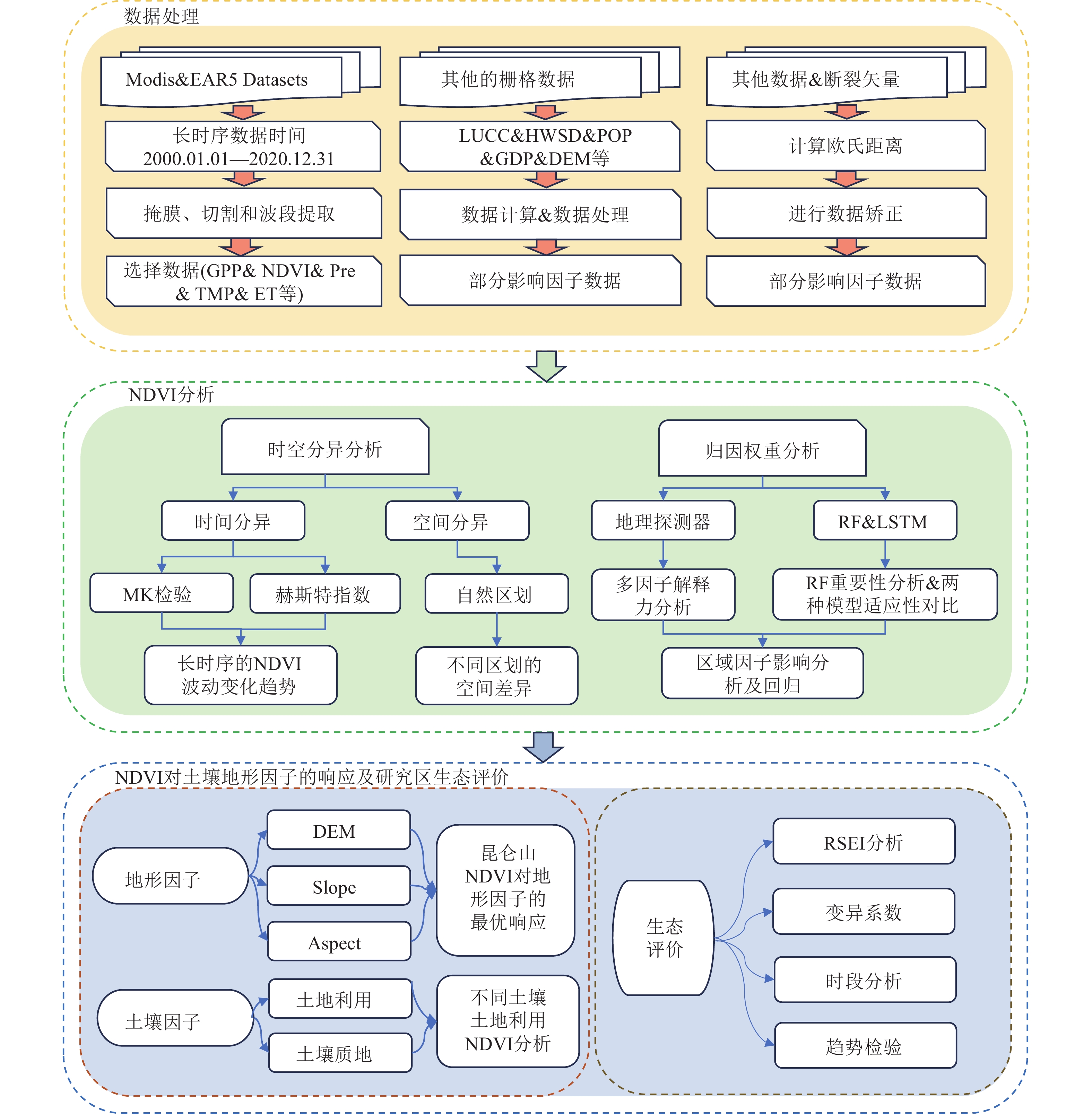
研究方法 本文基于归一化植被指数(Normalized Difference Vegetation Index, NDVI),探究了2000—2020年昆仑山植被覆盖度的时空变化规律。使用地理探测器(GeoDetector, GD)和随机森林 (Random Forest, RF)模型,识别了昆仑山地区NDVI变化的主导因子,使用RF和长短期记忆网络(Long Short−Term Memory Network, LSTM)开展了多因子NDVI的回归拟合。使用遥感生态指数(Remote Sensing Ecological Index, RSEI)评估了昆仑山环境质量变化状况。
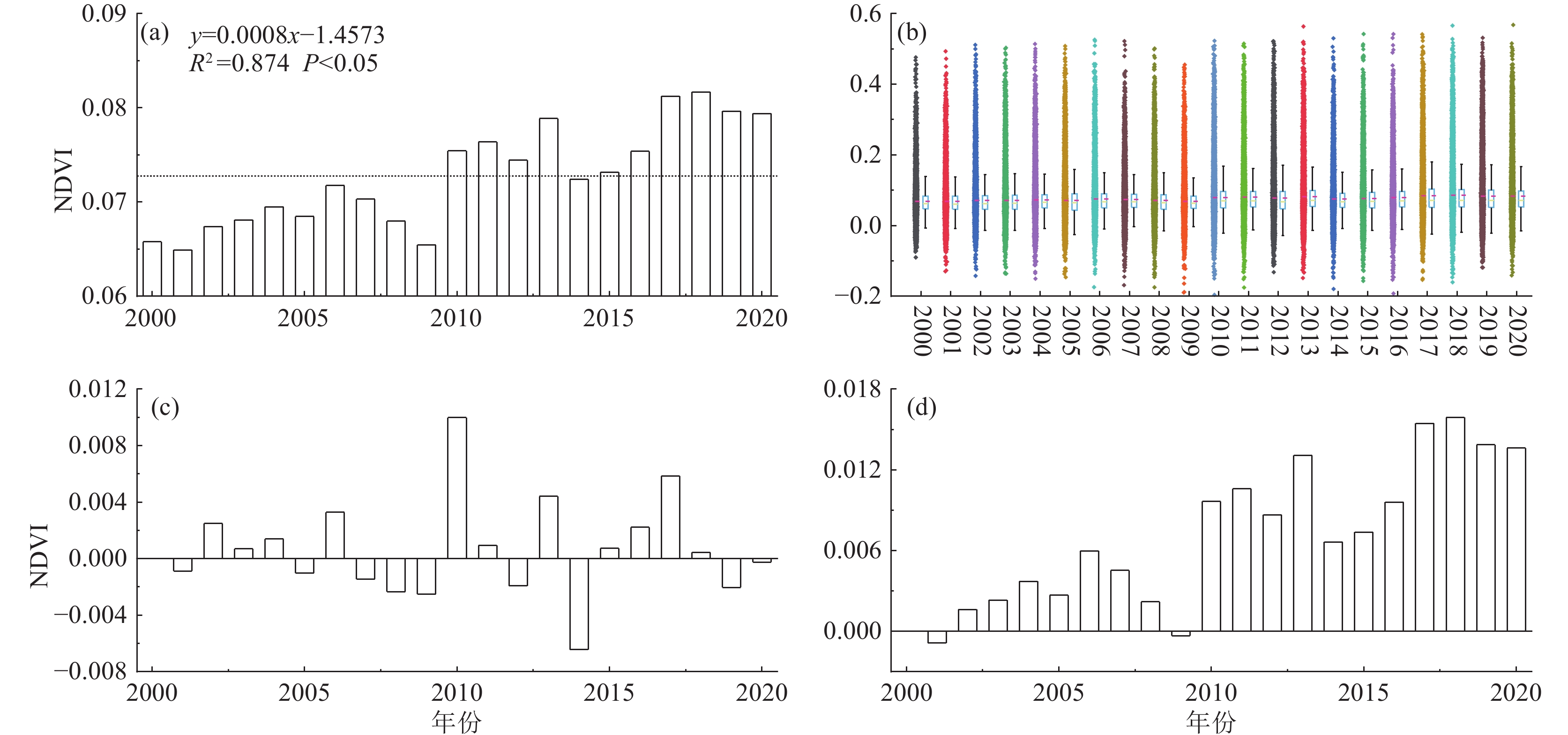
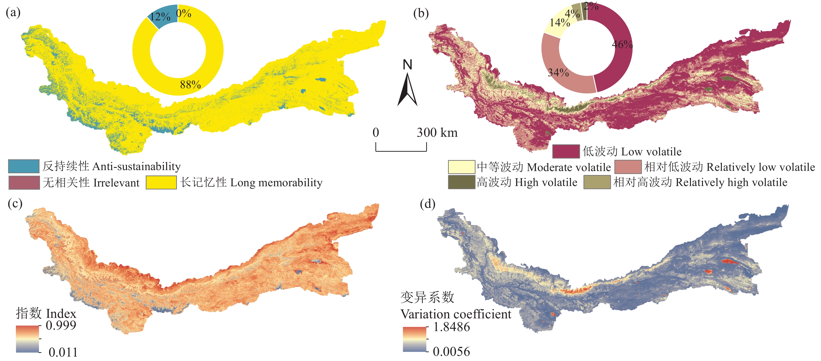
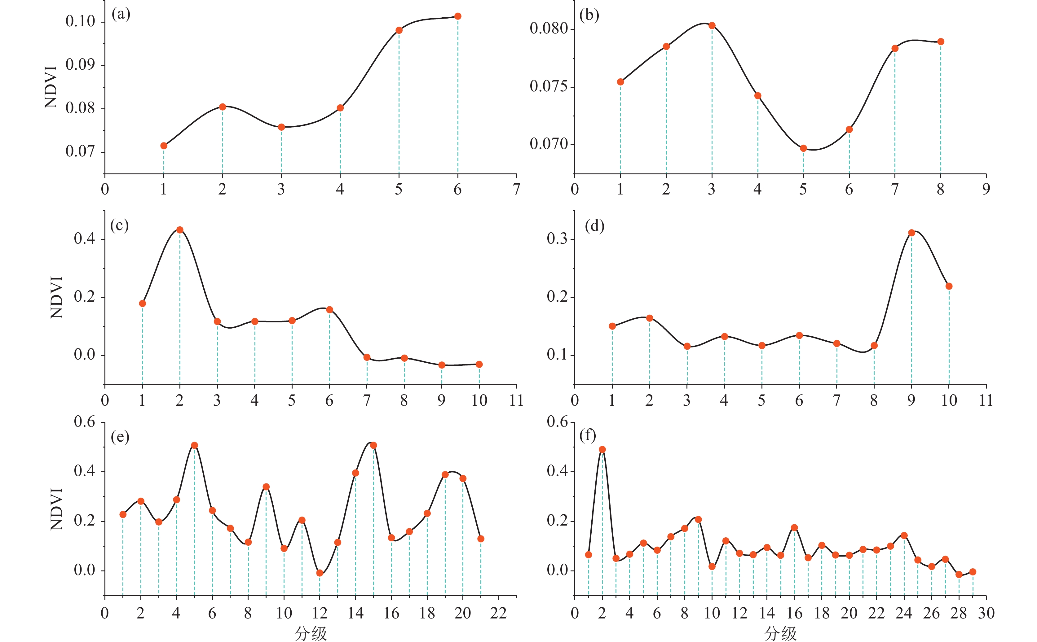
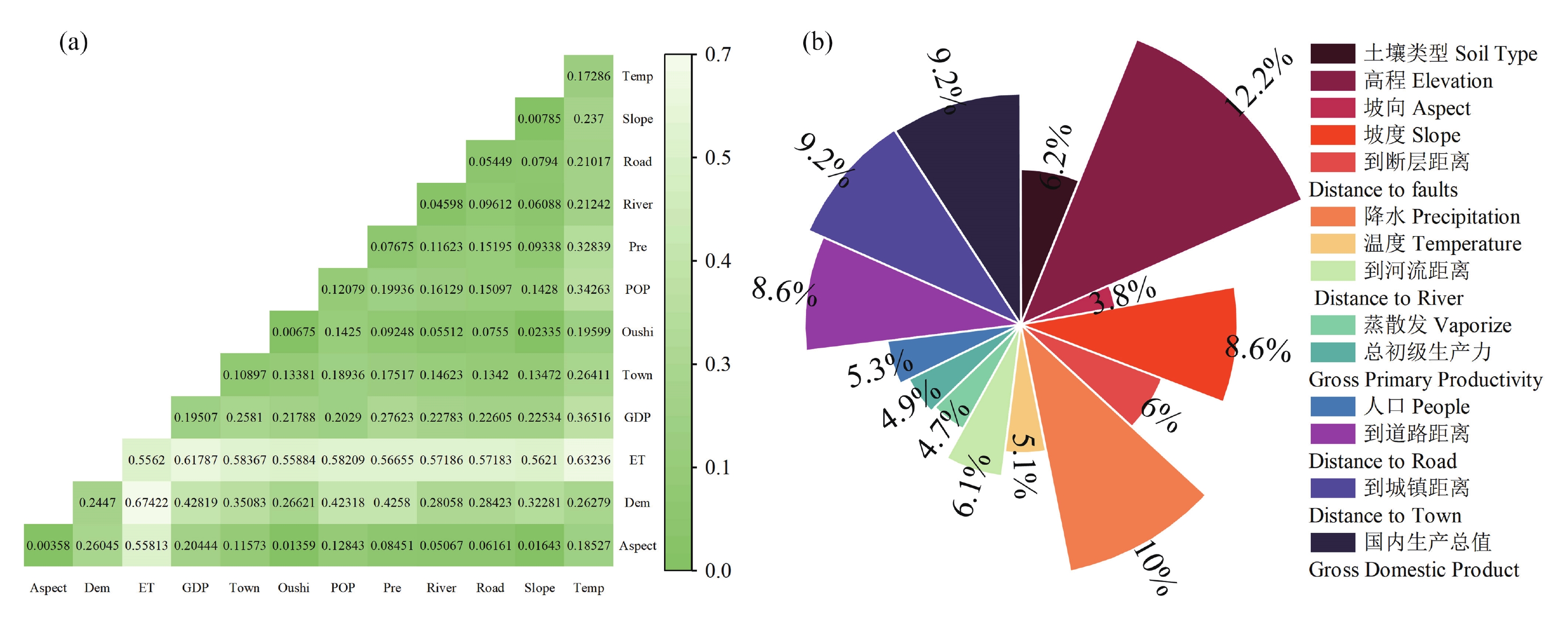
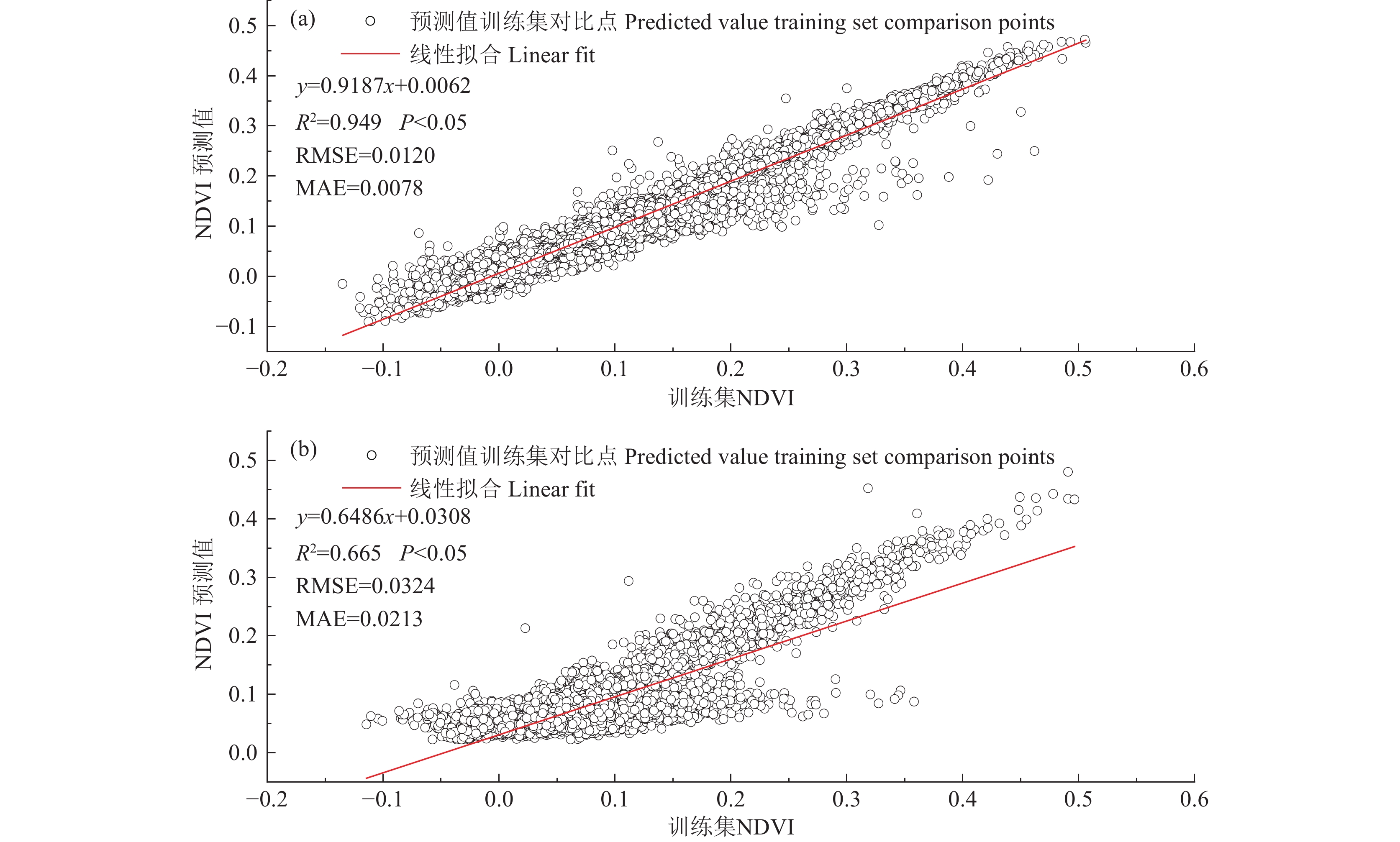
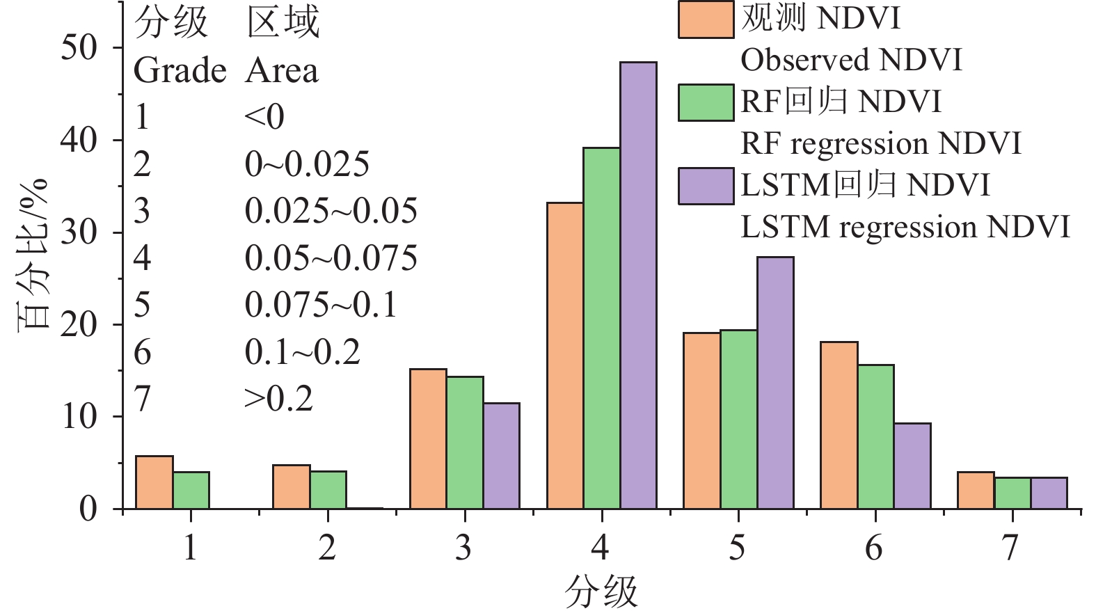
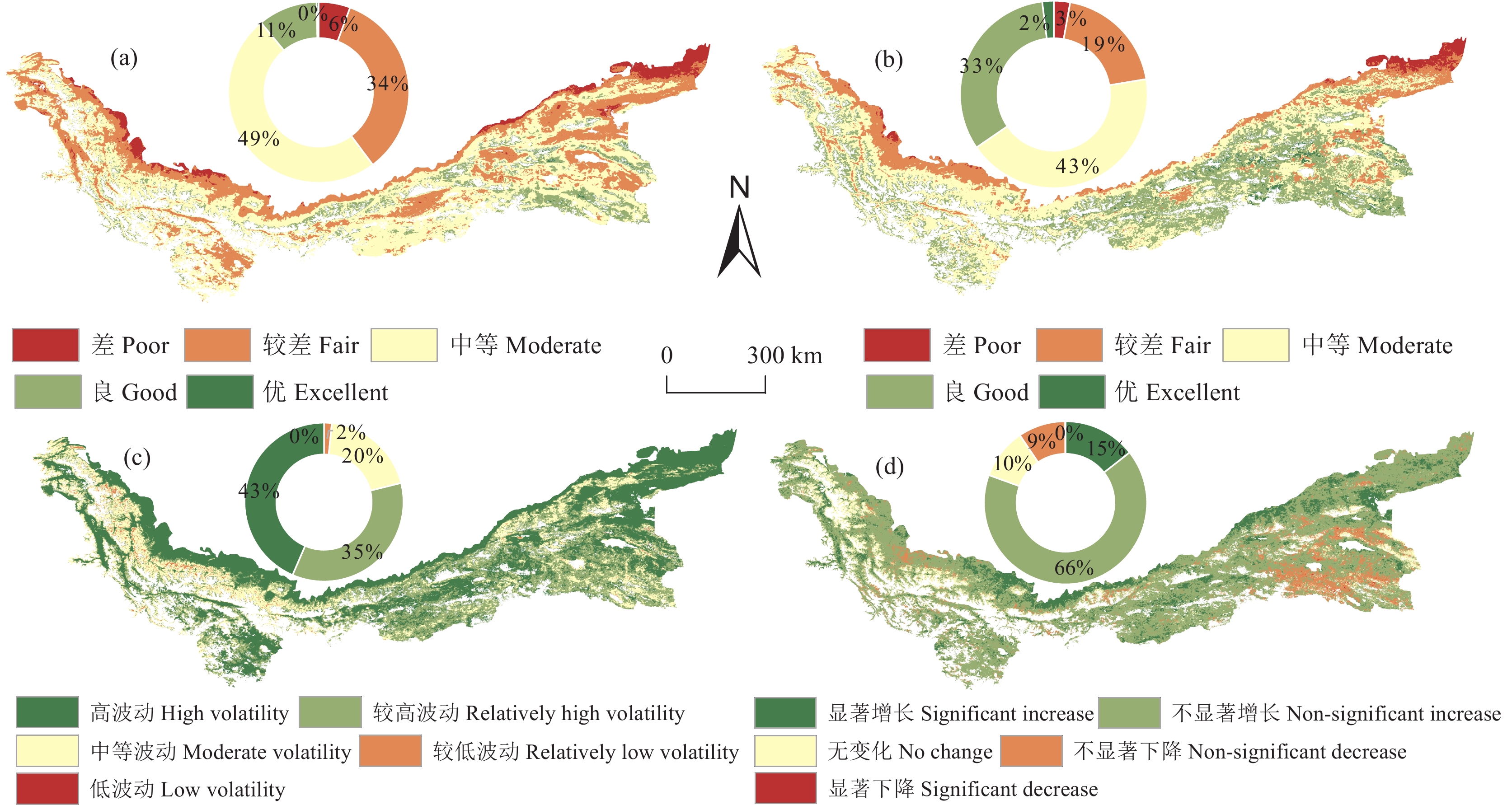
研究结果 2000—2020年昆仑山地区NDVI在时间上呈波动增加趋势,空间上呈“西高东低、北高南低”的分布格局。RF重要性最高的因子为高程(DEM)、降水(Pre)、到城镇距离(Town)和国内生产总值(Gross Domestic Product, GDP),GD解释力最高的因子为蒸散发(ET)、DEM、GDP和温度(Temp)。RF比LSTM更适用于昆仑山地区NDVI的回归拟合。RSEI数值上升的区域面积为80.52%,但整体波动较大,波动较大区域面积为78.86%。
结论 DEM、GDP、Pre和ET是影响该区域植被覆盖度的主要因素,区域生态环境质量有明显改善,生态保护措施成效显著。保护昆仑山生态脆弱区的生态稳定对区域生态政策的实施具有重要意义。
Abstract:This paper is the result of ecological geological survey engineering.
Objective Vegetation cover is a critical indicator of ecosystem stability. Researches about the factors influencing vegetation cover changes in the ecologically sensitive Kunlun Mountains region are limited. This study aims to analyze the spatiotemporal variations of vegetation cover and their driving factors in the Kunlun Mountains and to perform a regional ecological assessment.
Methods The Normalized Difference Vegetation Index (NDVI) was used to examine the spatiotemporal patterns of vegetation cover from 2000 to 2020, and the Geodetector (GD) and Random Forest (RF) models were applied to identify the primary drivers of NDVI changes. Meanwhile, RF and Long Short−Term Memory Network (LSTM) models were used for predict the NDVI variations, and the Remote Sensing Ecological Index (RSEI) was used to evaluate environmental quality.
Results NDVI showed a generally temporal increasing−decreasing−increasing trend, characterized by a spatial distribution that higher values in the west and north and lower values in the east and south. The RF model identified the digital elevation model (DEM), precipitation (Pre), distance to towns (Town), and gross domestic product (GDP) as the most influential factors, whereas the GD model showed evapotranspiration (ET), DEM, GDP, and temperature (Temp) had the greatest explanatory power. The RF model was more effective for NDVI regression analysis than the LSTM model in the study area. The RSEI value showed an increase in 80.52% of the area, but the overall variation was considerable, with 78.86% of the area showing significant variation.
Conclusions DEM, GDP, Pre, and ET are the primary factors affecting vegetation cover in the region and the significant improvement in the regional ecosystem over the past two decades. It also reveals a significant enhancement in regional ecological quality, indicating that ecological conservation measures have been effective.
-

-
表 1 数据来源
Table 1. Data sources
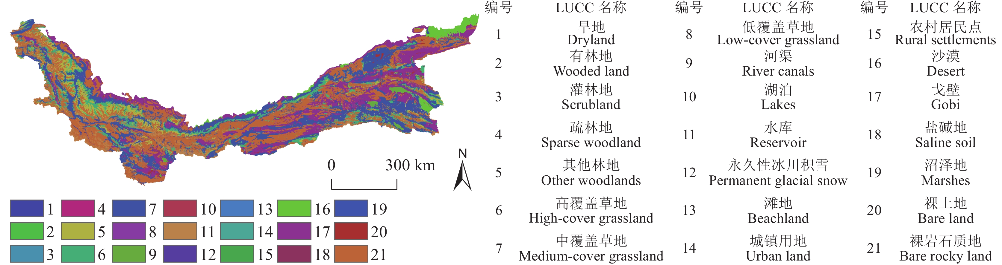
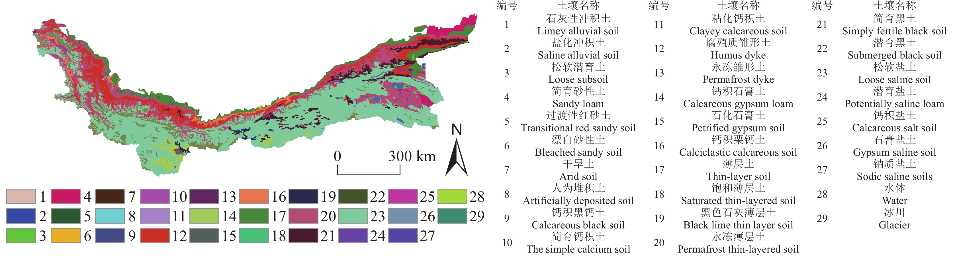
数据名称 数据描述 数据来源 DEM ASTER GDEM 30M分辨率数字高程模型 地理空间数据云( https://www.gscloud.cn/ )土地利用数据 中国多时期土地利用遥感监测数据集(CNLUCC)
1 km分辨率数据资源环境科学与数据中心( https://www.resdc.cn/ )土壤属性数据 HWSD 世界土壤数据库 粮农组织土壤门户网站(FAO SOILS PORTAL) NDVI(MYD13Q1) MODIS 500 m分辨率产品 NASA地球数据(EARTHDATA) 降水(Pre)
温度(Temp)
蒸散发(ET)ERA5 500 m分辨率数据 GEE数据网站( https://developers.google.com/earth-engine/datasets )断裂数据 新疆断裂带分布矢量数据 中国地质调查局 地质云V3.0( https://geocloud.cgs.gov.cn/ )经济、人口数据 1 km 分辨率栅格数据 资源环境科学与数据中心( https://www.resdc.cn/ )路网等矢量数据 矢量数据 全国地理信息资源目录服务系统( https://www.webmap.cn/ ) 下载: 导出CSV
表 2 地理探测器单因子解释力统计
Table 2. Explanatory power statistics of individual driving factors estimated by Geodetector (GD)
分析 Aspect DEM ET GDP Town Oushi POP Pre River Road Slope Temp q值 0.0036 0.2447 0.5562 0.1951 0.109 0.0067 0.1208 0.0768 0.046 0.0545 0.0079 0.1729 p值 0.000 0.000 0.000 0.000 0.000 0.000 0.000 0.000 0.000 0.000 0.000 0.000
下载: 导出CSV
-
[1] A Duo, Zhao Wenji, Gong Zhaoning, Zhang Min, Fan Yunbao. 2017. Temporal analysis of climate change and its relationship with vegetationcover on the north china plain from 1981 to 2013[J]. Acta Ecologica Sinica, 37(2): 576−592 (in Chinese with English abstract).
[2] Aiwen X U, Taibao Y, Congqiang W, Qin J I. 2016. Remote sensing monitoring of glacier changes in the Kelching River basin, Karakoram Mountains, 1978−2015[J]. Progress in Geography, 35: 878−888. doi: 10.18306/dlkxjz.2016.07.009
[3] Bai Jianjun, Bai Jiangtao, Wang Lei. 2014. Spatio-temporal Change of Vegetation NDVI and Its Relations withRegional Climate in Northern Shaanxi Province in 2000—2010[J]. Scientia Geographica Sinica, 34(7): 882−888 (in Chinese with English abstract).
[4] Bai Y, Yang Y, Jiang H. 2019. Intercomparison of AVHRR GIMMS3g, Terra MODIS, and SPOT−VGT NDVI Products over the Mongolian Plateau[J]. Remote Sensing, 11(17): 2030.
[5] Chen Chunbo, Li Gangyong. 2023. Temporal and spatial variation of grassland NDVl in Kunlun Mountains, Altun Mountains and its responses to temperature and precipitation from 1981 through 2020[J]. Chinese Journal of Grassland, 45: 13−25 (in Chinese with English abstract).
[6] Chen Yunhao, Li Xiaobing, Shi Peijun. 2001. Climate−driven analysis of land NDVI changes in China from 1983 to 1992[J]. Chinese Journal of Plant Ecology, 25(6): 716−720 (in Chinese with English abstract).
[7] Cheng Weiming, Zhou Chenghu, Chai Huixia, Zhao Shangmin, Li Bingyuan. 2009. Quantitative extraction and analysis of basic morphological types of land geomorphology in China[J]. Journal of Geo−information Science, 11(6): 725−736 (in Chinese with English abstract).
[8] Cheng Xin, Wang Xiaoyu, Cao Huairen, Zhang Chengjun. 2023. Application potential analysis of GDGTs temperature index in lakes on the Qinghai−Xizang Plateau: The case of Heihai Lake on Kunlun Mountain[J]. Advances in Earth Science, 38: 967−977 (in Chinese with English abstract).
[9] Chu H, Venevsky S, Wu C, Wang M. 2019. NDVI−based vegetation dynamics and its response to climate changes at Amur−Heilongjiang River Basin from 1982 to 2015[J]. Science of The Total Environment, 650: 2051−2062. doi: 10.1016/j.scitotenv.2018.09.115
[10] Deng Y, Wang S, Bai X, Tian Y, Wu L, Xiao J, Chen F, Qian Q. 2018. Relationship among land surface temperature and LUCC, NDVI in typical karst area[J]. Scientific Reports, 8(1): 641. doi: 10.1038/s41598-017-19088-x
[11] Fang W, Huang S, Huang Q, Huang G, Wang H, Leng G, Wang L, Guo Y. 2019. Probabilistic assessment of remote sensing−based terrestrial vegetation vulnerability to drought stress of the Loess Plateau in China[J]. Remote Sensing of Environment, 232: 111290. doi: 10.1016/j.rse.2019.111290
[12] Fu Yujia, Tan Changhai, Liu Xiaohuang, Sun Xingli, Yuan Zemin, Zheng Yiwen. 2022. Definition, classification, observation and monitoring of natural resourcesand their application in territorial planning and governance[J]. Geology in China, 49(4): 1048−1063 (in Chinese with English abstract).
[13] Gao Jun, Li Jie, Fu Jing, Bao Yanni, Ma Shitong, Li Weiyue, Guo Xin. 2021. Spatial patterns of ecoregions and protected areas in the Karakoram−Himalayan region[J]. Acta Ecologica Sinica, 41: 912−923 (in Chinese with English abstract).
[14] Gao Peixing, Wang Xiuhua. 2011. Regional differences and influencing factors of rural financial exclusion in china: An empirical analysis based on interprovincial data[J]. Journal of Agrotechnical Economics, (4): 93−102 (in Chinese with English abstract).
[15] Gao W, Zheng C, Liu X, Lu Y, Chen Y, Wei Y, Ma Y. 2022. NDVI−based vegetation dynamics and their responses to climate change and human activities from 1982 to 2020: A case study in the Mu Us Sandy Land, China[J]. Ecological Indicators, 137: 108745. doi: 10.1016/j.ecolind.2022.108745
[16] Geng W, Li Y, Zhang P, Yang D, Jing W, Rong T. 2022. Analyzing spatio−temporal changes and trade−offs/synergies among ecosystem services in the Yellow River Basin, China[J]. Ecological Indicators, 138: 108825. doi: 10.1016/j.ecolind.2022.108825
[17] Guo Jianqiang, Wang Zhaoliang, He Xiaomin. 2016. Division and characteristics of Devonian strata in the Karakorum Mountains area in Xinjiang[J]. Geology in China, 43(3): 987−999 (in Chinese with English abstract).
[18] Hakkar N, Dhayal R, Debbouche A, Torres D F M. 2023. Approximate controllability of delayed fractional stochastic differential systems with mixed noise and impulsive effects[J]. Fractal and Fractional, 7(2): 104. doi: 10.3390/fractalfract7020104
[19] Hmimina G, Dufrêne E, Pontailler J Y, Delpierre N, Aubinet M, Caquet B, de Grandcourt A, Burban B, Flechard C, Granier A, Gross P, Heinesch B, Longdoz B, Moureaux C, Ourcival J M, Rambal S, Saint André L, Soudani K. 2013. Evaluation of the potential of MODIS satellite data to predict vegetation phenology in different biomes: An investigation using ground−based NDVI measurements[J]. Remote Sensing of Environment, 132: 145−158. doi: 10.1016/j.rse.2013.01.010
[20] Hu Keke, He Jiancun, Zhao Jian, Ta Yier, Su Lidan. 2023. Spatial and temporal characteristics of ecological base flow in typical rivers at the northern slope of Kunlun Mountains in the past four decades[J]. Journal of Changjiang River Scientific Research Institute, 41(1): 44 (in Chinese with English abstract).
[21] Jin Kai, Wang Fei, Han Jianqiao, Shi Shangyu, Ding Wenbin. 2020. Contribution of climatic change and human activities to vegetation NDVI change over China during 1982−2015[J]. Acta Geographica Sinica, 75(5): 961−974 (in Chinese with English abstract).
[22] Ju J, Masek J G. 2016. The vegetation greenness trend in Canada and US Alaska from 1984–2012 Landsat data[J]. Remote Sensing of Environment, 176: 1−16. doi: 10.1016/j.rse.2016.01.001
[23] Karevan Z, Suykens J A K. 2020. Transductive LSTM for time−series prediction: An application to weather forecasting[J]. Neural Networks, 125: 1−9. doi: 10.1016/j.neunet.2019.12.030
[24] Li G, Sun S, Han J, Yan J, Liu W, Wei Y, Lu N, Sun Y. 2019. Impacts of Chinese Grain for Green program and climate change on vegetation in the Loess Plateau during 1982–2015[J]. Science of The Total Environment, 660: 177−187. doi: 10.1016/j.scitotenv.2019.01.028
[25] Li H, Liu X, Zhao X, Zhang W, Liu J, Luo X, Wang R, Xing L. 2023. Contrasting effects of tectonic faults on vegetation growth along the elevation gradient in tectonically active mountains[J]. Forests, 14(12): 2336. doi: 10.3390/f14122336
[26] Li S, Xu L, Jing Y, Yin H, Li X, Guan X. 2021. High−quality vegetation index product generation: A review of NDVI time series reconstruction techniques[J]. International Journal of Applied Earth Observation and Geoinformation, 105: 102640. doi: 10.1016/j.jag.2021.102640
[27] Liu Hui. 2006. Regional inequality measurement: Methods and evaluations[J]. Geographical Research, (4): 710−718 (in Chinese with English abstract).
[28] Liu Ronghua, Li Baofu. 2023. Spatial−temporal variation characteristics of LST during 2000−2016 in the Karakoram−West Kunlun Mountains region[J]. Journal of Qufu Normal University (Natural Science), 49(1): 10−17, 137 (in Chinese with English abstract).
[29] Liu Xianfeng, Pan Yaozhong, Zhu Xiufang, Li Shuangshuang. 2015. Spatiotemporal variation of vegetation coverage in Qinling−DabaMountains in relation to environmental factors[J]. Acta Geographica Sinica, 70(5): 705−716 (in Chinese with English abstract).
[30] Liu Yuting, Zhang Qifei, Liu Jingshi, Guan Xianxiao, Meng Fanxue. 2022. Temporal and spatial characteristics of fractional vegetation coverage andits response to climatic factors in southern Xinjiang in recent 20 years: A case of Taxkorgan Tajik Autonomous County[J]. Arid Land Geography, 45(5): 1481−1489 (in Chinese with English abstract).
[31] Liu Y, Li Z, Chen Y, Li Y, Li H, Xia Q, Kayumba P M. 2022. Evaluation of consistency among three NDVI products applied to High Mountain Asia in 2000–2015[J]. Remote Sensing of Environment, 269: 112821. doi: 10.1016/j.rse.2021.112821
[32] Martinez A D L I, Labib S M. 2023. Demystifying normalized difference vegetation index (NDVI) for greenness exposure assessments and policy interventions in urban greening[J]. Environmental Research, 220: 115155. doi: 10.1016/j.envres.2022.115155
[33] Meng Chengfeng, Zhong Tao, Zheng Jianghua, Wang Nan, Liu Zexuan, Ren Xiangyuan. 2023. Analysis of temporal and spatial characteristics and driving forces of Kunlun glacial lakes[J]. Arid Zone Research, 40(7): 1094−1106 (in Chinese with English abstract).
[34] Peng W, Kuang T, Tao S. 2019. Quantifying influences of natural factors on vegetation NDVI changes based on geographical detector in Sichuan, western China[J]. Journal of Cleaner Production, 233: 353−367. doi: 10.1016/j.jclepro.2019.05.355
[35] Pinzon J, Tucker C. 2014. A Non−Stationary 1981–2012 AVHRR NDVI3g Time Series[J]. Remote Sensing, 6(8): 6929−6960. doi: 10.3390/rs6086929
[36] Schonlau M, Zou R Y. 2020. The random forest algorithm for statistical learning[J]. The Stata Journal, 20(1): 3−29. doi: 10.1177/1536867X20909688
[37] Scornet E, Biau G, Vert J P. 2015. Consistency of random forests[J]. The Annals of Statistics, 43: 1716−1741.
[38] Sherstinsky A. 2020. Fundamentals of recurrent neural network (RNN) and long short−term memory (LSTM) network[J]. Physica D: Nonlinear Phenomena, 404: 132306. doi: 10.1016/j.physd.2019.132306
[39] Su Hongjun, Xu Zhonglin. 2022. Temporal and spatial dynamics analysis of vegetation index in Xinjiang from 2000 to 2015[J]. Hubei Agricultural Sciences, 61(10): 48−55,63 (in Chinese with English abstract).
[40] Tang Guoan, Song Jia. 2006. Comparison of slope classification methods in slope mapping from DEMs[J]. Journal of Soil and Water Conservation, 20(2): 157−160 (in Chinese with English abstract).
[41] Tian F, Fensholt R, Verbesselt J, Grogan K, Horion S, Wang Y. 2015. Evaluating temporal consistency of long−term global NDVI datasets for trend analysis[J]. Remote Sensing of Environment, 163: 326−340. doi: 10.1016/j.rse.2015.03.031
[42] Wang Jinfeng, Xu Chengdong. 2017. Geodetector: Principle and prospective[J]. Acta Geographica Sinica, 72(1): 116−134 (in Chinese with English abstract).
[43] Wang Yao, Chen Ruisan, Guo Chihui, Xia Zilong. 2021. Changes of resource and environmental pattern of the Yellow River Basin inthe past 40 years and suggestions on geological work[J]. Geology in China, 48(1): 1−20 (in Chinese with English abstract).
[44] Wang Y, Xu Y, Tabari H, Wang J, Wang Q, Song S, Hu Z. 2020. Innovative trend analysis of annual and seasonal rainfall in the Yangtze River Delta, eastern China[J]. Atmospheric Research, 231: 104673. doi: 10.1016/j.atmosres.2019.104673
[45] Wen Z, Wu S, Chen J, Lü M. 2017. NDVI indicated long−term interannual changes in vegetation activities and their responses to climatic and anthropogenic factors in the Three Gorges Reservoir Region, China[J]. Science of The Total Environment, 574: 947−959. doi: 10.1016/j.scitotenv.2016.09.049
[46] Xu Hanqiu. 2013a. Creation and application of urban remote sensing ecological index[J]. Acta Ecologica Sinica, 33(24): 7853−7862 (in Chinese with English abstract).
[47] Xu Hanqiu. 2013b. A remote sensing index for assessment of regional ecological changes[J]. China Environmental Science, 33(5): 889−897 (in Chinese with English abstract).
[48] Xue Qiang, Zhang Maosheng, Dong Ying, Meng Xiaojie, Guo Xiaopeng, Feng Wei, Hong Bo, Wang Tao, Liu Wenhui, Tian Zhongying, Zhang Ge, Lu Na. 2023. Refinement risk identification of loess geo−hazards based on DEM and remote sensing——Taking Mizhi County in the Loess Plateau of Northern Shaanxi as an example[J]. Geology in China, 50(3): 926−942 (in Chinese with English abstract).
[49] Yan Wei, Liu Jingshi, Luo Guangming, Dong Kepeng, Lu Wei, Du Xinhao. 2014. Changes in snowpack area in the Yulongkashi River Basin of the West Kunlun Mountains from 2000 to 2013 based on MODIS data[J]. Progress in Geography, 33(3): 315−325 (in Chinese with English abstract).
[50] Yan Zhiyuan, Zhang Shengwei, Wang Yixuan. 2023. Spatiotemporal dynamics of vegetation coverage and climate response in Inner Mongolia during 1982−2021 based on GEE[J]. Transactions of the Chinese Society of Agricultural Engineering, 39(15): 94−102 (in Chinese with English abstract).
[51] Yi Lang, Ren Zhiyuan, Zhang Chong, Liu Wen. 2014. Changes in vegetation cover on the Loess Plateau in relation to climate and human activities[J]. Resources Science, 36(1): 166−174 (in Chinese with English abstract).
[52] Yuan J, Liu X, Li H, Wang R, Luo X, Xing L, Wang C, Zhao H. 2023. Assessment of spatial–temporal variations of soil erosion in Hulunbuir Plateau from 2000 to 2050[J]. Land, 12(6): 1214. doi: 10.3390/land12061214
[53] Zhang J, Xiao J, Tong X, Zhang J, Meng P, Li J, Liu P, Yu P. 2022a. NIRv and SIF better estimate phenology than NDVI and EVI: Effects of spring and autumn phenology on ecosystem production of planted forests[J]. Agricultural and Forest Meteorology, 315: 108819. doi: 10.1016/j.agrformet.2022.108819
[54] Zhang S, Bai X, Zhao C, Tan Q, Luo G, Cao Y, Deng Y, Li Q, Li C, Wu L, Wang J, Chen F, Xi H, Ran C, Liu M. 2022b. Limitations of soil moisture and formation rate on vegetation growth in karst areas[J]. Science of The Total Environment, 810: 151209. doi: 10.1016/j.scitotenv.2021.151209
[55] Zheng Chunyan, Liang Junhong, Wang Jian. 2022. The impact of climate and land use on the spatio−temporal changes of NDVI of China−Pakistan Economic Corridor[J]. Journal of Ecology and Rural Environment, 38(9): 1147−1156 (in Chinese with English abstract).
[56] Zheng Yiwen, Li Fujie, Liu Xiaohuang, Chang Ming, Zhao Honghui, Lai Ming, Zhang Zifan. 2022. Temporal and spatial variation of natural resources and their ecological environment effects in Northeast China in the past 30 years under the background of industrialization[J]. Geology in China, 49(5): 1361−1373 (in Chinese with English abstract).
[57] Zhu L, Meng J, Zhu L. 2020. Applying geodetector to disentangle the contributions of natural and anthropogenic factors to NDVI variations in the middle reaches of the Heihe River Basin[J]. Ecological Indicators, 117: 106545. doi: 10.1016/j.ecolind.2020.106545
[58] 阿多, 赵文吉, 宫兆宁, 张敏, 范云豹. 2017. 1981—2013华北平原气候时空变化及其对植被覆盖度的影响[J]. 生态学报, 37(2): 576−592.
[59] 白建军, 白江涛, 王磊. 2014. 2000—2010年陕北地区植被NDVI时空变化及其与区域气候的关系[J]. 地理科学, 34(7): 882−888.
[60] 陈春波, 李刚勇. 2023. 1981—2020年昆仑山阿尔金山草地NDVI时空变化及其对气温、降水的响应[J]. 中国草地学报, 45: 13−25.
[61] 陈云浩, 李晓兵, 史培军. 2001. 1983—1992年中国陆地NDVI变化的气候因子驱动分析[J]. 植物生态学报, 25(6): 716−720. doi: 10.3321/j.issn:1005-264X.2001.06.012
[62] 程维明, 周成虎, 柴慧霞, 赵尚民, 李炳元. 2009. 中国陆地地貌基本形态类型定量提取与分析[J]. 地球信息科学学报, 11(6): 725−736. doi: 10.3969/j.issn.1560-8999.2009.06.007
[63] 程昕, 王小雨, 曹怀仁, 张成君. 2023. GDGTs温度指标在青藏高原湖泊的应用潜力分析——以昆仑山黑海为例[J]. 地球科学进展, 38: 967−977.
[64] 付宇佳, 谭昌海, 刘晓煌, 孙兴丽, 袁泽民, 郑艺文. 2022. 自然资源定义, 分类, 观测监测及其在国土规划治理中的应用[J]. 中国地质, 49(4): 1048−1063. doi: 10.12029/gc20220402
[65] 高峻, 李杰, 付晶, 鲍燕妮, 马施彤, 李巍岳, 郭鑫. 2021. 喀喇昆仑山—喜马拉雅山脉生态区类型与保护地空间分布格局[J]. 生态学报, 41: 912−923.
[66] 高沛星, 王修华. 2011. 我国农村金融排斥的区域差异与影响因素——基于省际数据的实证分析[J]. 农业技术经济, (4): 93−102.
[67] 郭建强, 王照亮, 何小敏. 2016. 新疆喀喇昆仑山地区泥盆纪地层划分与特征[J]. 中国地质, 43(3): 987−999. doi: 10.12029/gc20160321
[68] 胡可可, 何建村, 赵健, 塔依尔, 苏里坦. 2023. 近40a昆仑山北麓典型河流生态基流时空特征分析[J]. 长江科学院院报, 41(1): 44.
[69] 金凯, 王飞, 韩剑桥, 史尚渝, 丁文斌. 2020. 1982—2015年中国气候变化和人类活动对植被NDVI变化的影响[J]. 地理学报, 75(5): 961−974. doi: 10.11821/dlxb202005006
[70] 刘慧. 2006. 区域差异测度方法与评价[J]. 地理研究, (4): 710−718. doi: 10.3321/j.issn:1000-0585.2006.04.018
[71] 刘荣华, 李宝富. 2023. 2000—2016年喀喇昆仑—西昆仑山地表温度时空变化特征[J]. 曲阜师范大学学报(自然科学版), 49(1): 10−17,137.
[72] 刘宪锋, 潘耀忠, 朱秀芳, 李双双. 2015. 2000—2014年秦巴山区植被覆盖时空变化特征及其归因[J]. 地理学报, 70(5): 705−716. doi: 10.11821/dlxb201505003
[73] 刘玉婷, 张齐飞, 刘景时, 关含笑, 孟凡雪. 2022. 近20 a新疆南部植被覆盖度时空特征及对气候因素的响应—以塔什库尔干塔吉克自治县为例[J]. 干旱区地理, 45(5): 1481−1489. doi: 10.12118/j.issn.1000-6060.2021.606
[74] 孟乘枫, 仲涛, 郑江华, 王南, 刘泽轩, 任祥源. 2023. 昆仑山冰湖分布时空特征及驱动力[J]. 干旱区研究, 40(7): 1094−1106.
[75] 苏红军, 许仲林. 2022. 2000—2015年新疆植被指数的时空动态分析[J]. 湖北农业科学, 61(10): 48−55, 63.
[76] 汤国安, 宋佳. 2006. 基于DEM坡度图制图中坡度分级方法的比较研究[J]. 水土保持学报, 20(2): 157−160. doi: 10.3321/j.issn:1009-2242.2006.02.038
[77] 王劲峰, 徐成东. 2017. 地理探测器: 原理与展望[J]. 地理学报, 72(1): 116−134. doi: 10.11821/dlxb201701010
[78] 王尧, 陈睿山, 郭迟辉, 夏子龙. 2021. 近40年黄河流域资源环境格局变化分析与地质工作建议[J]. 中国地质, 48(1): 1−20. doi: 10.12029/gc20210101
[79] 徐涵秋. 2013a. 城市遥感生态指数的创建及其应用[J]. 生态学报, 33(24): 7853−7862.
[80] 徐涵秋. 2013b. 区域生态环境变化的遥感评价指数[J]. 中国环境科学, 33(5): 889−897.
[81] 薛强, 张茂省, 董英, 孟晓捷, 郭小鹏, 冯卫, 洪勃, 王涛, 刘文辉, 田中英, 张戈, 卢娜. 2023. 基于DEM和遥感的黄土地质灾害精细化风险识别—以陕北黄土高原区米脂县为例[J]. 中国地质, 50(3): 926−942. doi: 10.12029/gc20220801001
[82] 颜伟, 刘景时, 罗光明, 董克鹏, 卢巍, 杜新豪. 2014. 基于MODIS数据的2000—2013年西昆仑山玉龙喀什河流域积雪面积变化[J]. 地理科学进展, 33(3): 315−325. doi: 10.11820/dlkxjz.2014.03.003
[83] 闫志远, 张圣微, 王怡璇. 2023. 基于GEE的1982—2021年内蒙古地区植被覆盖度时空动态及气候响应特征[J]. 农业工程学报, 39(15): 94−102. doi: 10.11975/j.issn.1002-6819.202301033
[84] 易浪, 任志远, 张翀, 刘雯. 2014. 黄土高原植被覆盖变化与气候和人类活动的关系[J]. 资源科学, 36(1): 166−174.
[85] 郑春燕, 梁俊红, 王建. 2022. 中巴经济走廊归一化植被指数(NDVI)时空变化及影响因素分析[J]. 生态与农村环境学报, 38(9): 1147−1156.
[86] 郑艺文, 李福杰, 刘晓煌, 常铭, 赵宏慧, 赖明, 张子凡. 2022. 工业化背景下 30 年来中国东北地区自然资源时空变化及其生态环境效应[J]. 中国地质, 49(5): 1361−1373. doi: 10.12029/gc20220501
-


图(13)
表(2)
计量
- 文章访问数: 540
- PDF下载数: 100
- 施引文献: 0