

Exploring Luorite Veins Using Multi-source Remote Sensing Astellite Data: A Case Study from the Shuitou Fluorite Deposit in Inner Mongolia, China
-
摘要:
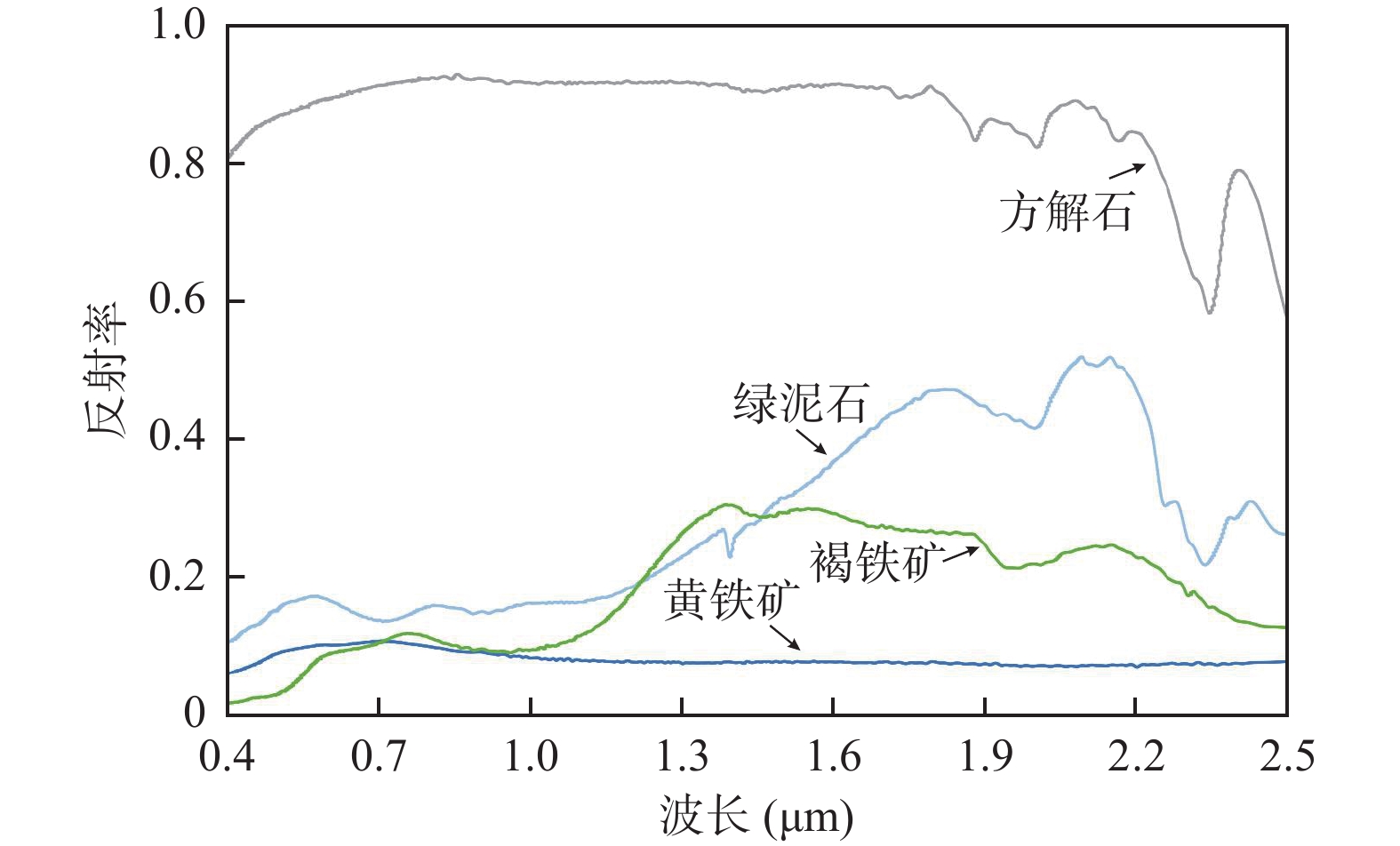
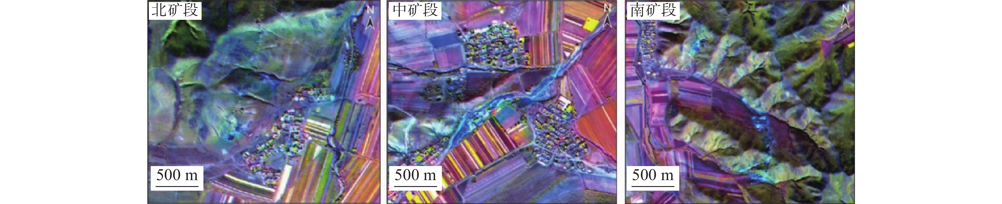
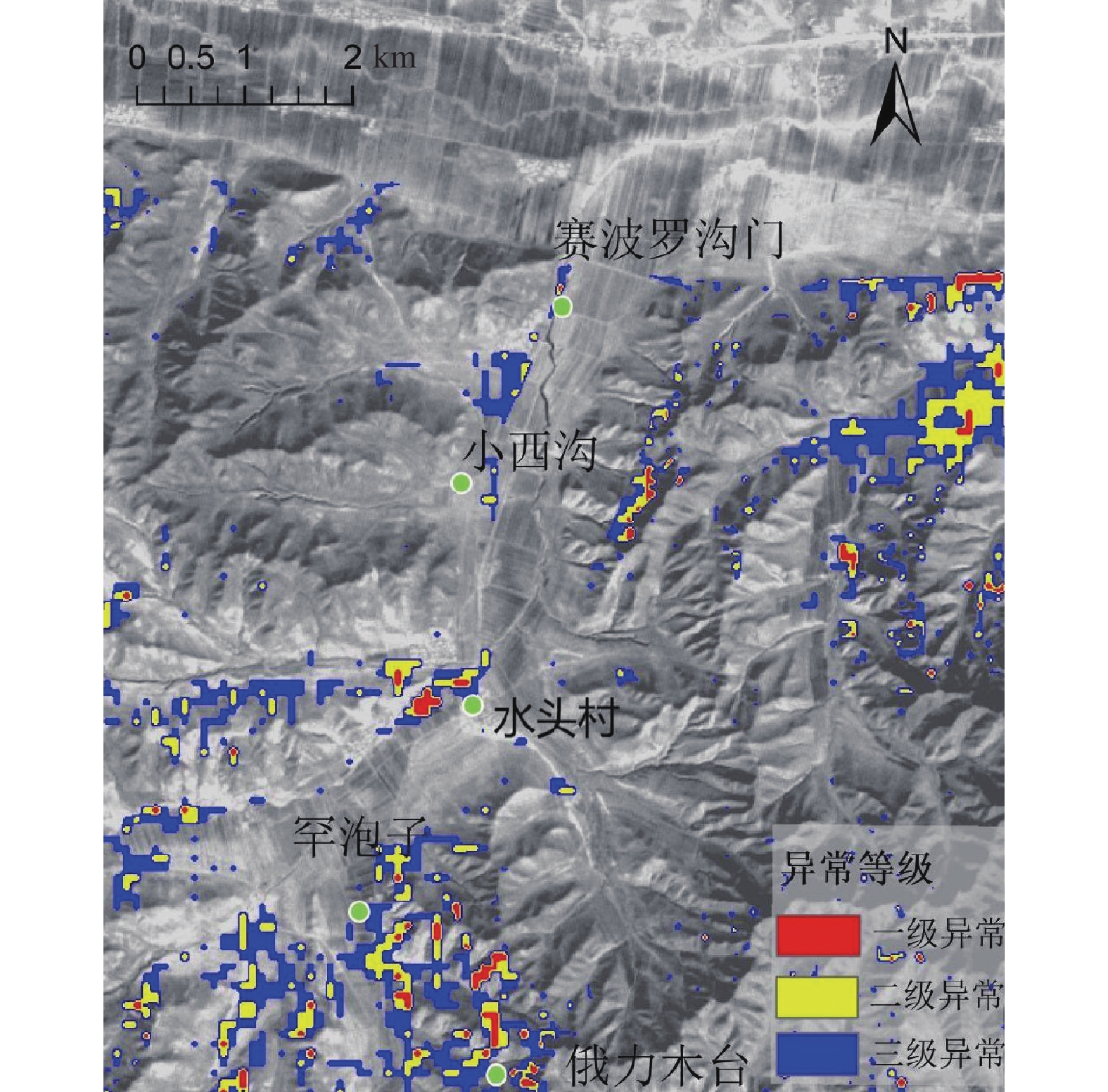
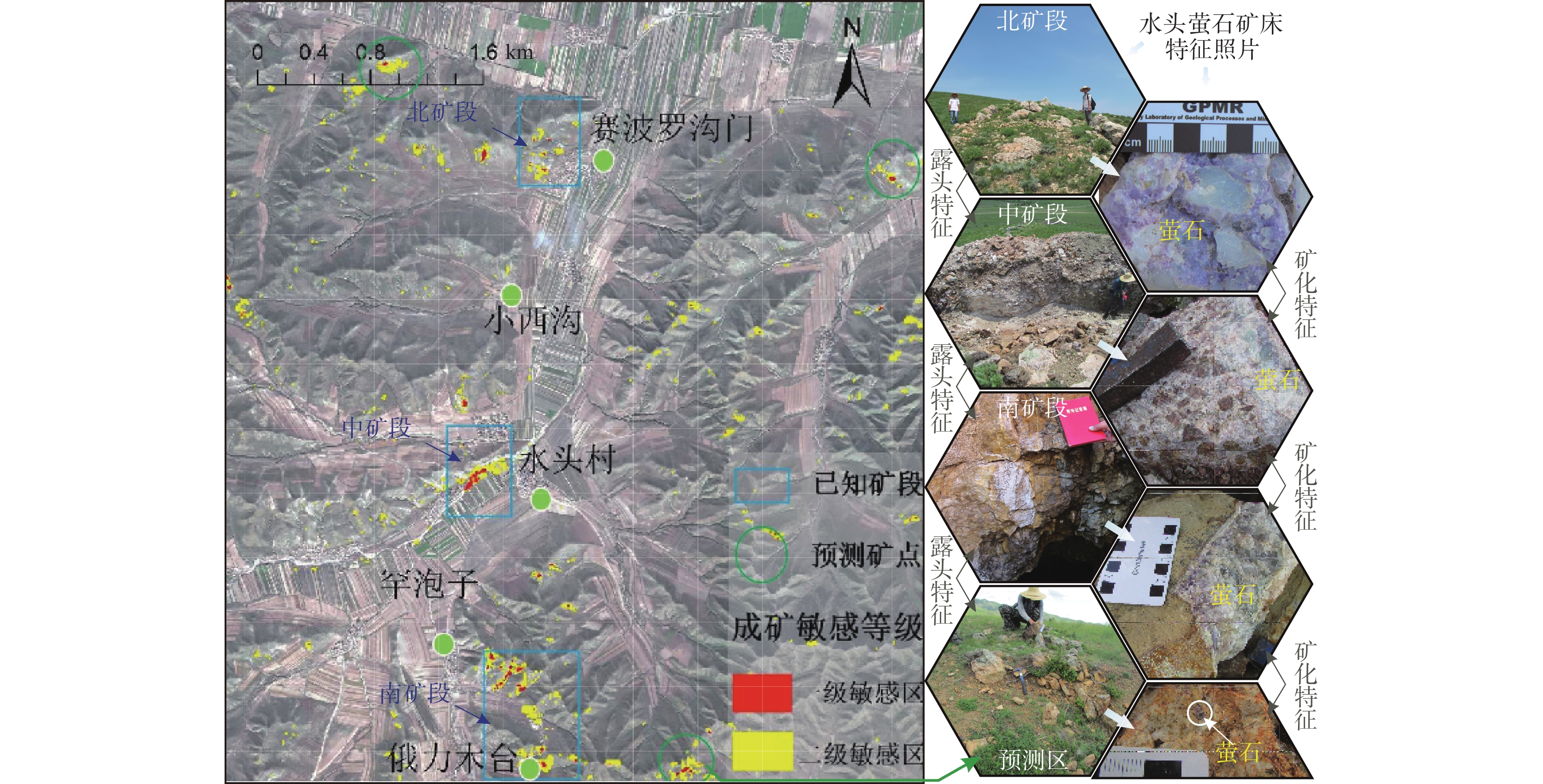
萤石是一种战略性非金属矿产,脉状萤石矿床是全球萤石产量的主要来源,应用遥感技术开展脉状萤石矿床的勘查找矿研究具有重要意义。笔者选择内蒙古中东部水头萤石矿床为研究区,在野外地质调查和前期研究的基础上,综合应用Landsat-8、ASTER、Sentinel-2和WorldView-2多源遥感影像进行成矿预测。首先,基于光谱协同理论将Landsat-8与WorldView-2融合生成协同数据,对研究区地层岩性和控矿构造进行遥感解译;利用Sentinel-2和ASTER影像进行了羟基、铁染和硅化蚀变信息提取。基于已知萤石矿点的遥感解译特征建立研究区萤石矿的遥感解译标志,在此基础上,应用GIS平台对提取特征信息进行加权叠加分析,开展研究区内萤石矿的综合预测。研究结果表明:Landsat-8与WorldView-2数据融合的假彩色合成影像可有效区分研究区萤石矿化点;由于脉状萤石矿体具有明显的垂向分带特征,在研究区地表露头中多发育硅质顶盖,因此硅化蚀变异常与羟基异常组合可作为萤石矿化的重要特征依据。GIS综合预测结果与已知矿点吻合度高,证实了应用多源遥感数据在脉状萤石矿床勘查找矿中的有效性,并预测了三处新的靶区,相关结果可为后续勘查部署提供依据,也可为其他地区的萤石遥感找矿勘查提供参考。
Abstract:Fluorite is a strategic nonmetallic mineral. Vein fluorite deposits represent the primary source of global fluorite production. The application of remote sensing technology to the exploration and mineral searches of vein-type fluorite deposits is of great significance. In this paper, the Shuitou fluorite deposit in the east-central part of Inner Mongolia is selected as the study area. Based on a comprehensive field geological survey and preliminary research, the authors apply a multi-source remote sensing approach using Landsat-8, ASTER, Sentinel-2, and WorldView-2 images to make mineralization predictions. First, spectral synergy theory was employed to fuse Landsat-8 and WorldView-2 data, thereby generating synergistic data for remote sensing interpretation of stratigraphic lithology and ore-controlling tectonic information in the study area. Additionally, hydroxyl, iron-stained, and silicified alteration information was extracted from Sentinel-2 and ASTER images. Based on the remote sensing interpretation features of known fluorite mining sites, a remote sensing interpretation flag of fluorite mining in the study area was established. This was then applied to the GIS platform, which was used to analyze the extracted feature information with weighted superposition and to carry out a comprehensive prediction of fluorite mining in the study area. The results demonstrate that the false-color composite image, which has been fused with data from both Landsat-8 and WorldView-2, is an effective tool for distinguishing fluorite mineralization points. In vein-type fluorite deposits, the ore body exhibits distinct vertical zonation, while in surface outcrops, more siliceous tops develop. The combination of silica and hydroxyl alteration anomalies can be used as the basis for identifying the key characteristics of fluorite mineralization. The results of this comprehensive GIS prediction and the known ore points align well, thereby corroborating the efficacy of the utilization of multisource remote sensing data in vein-type fluorite deposits for the purposes of exploration and the search for minerals, as well as the prediction of three new target areas. The results are suitable for use as a basis for subsequent surveys and as a reference for the remote sensing of fluorite vein systems exploration in other areas.
-

-
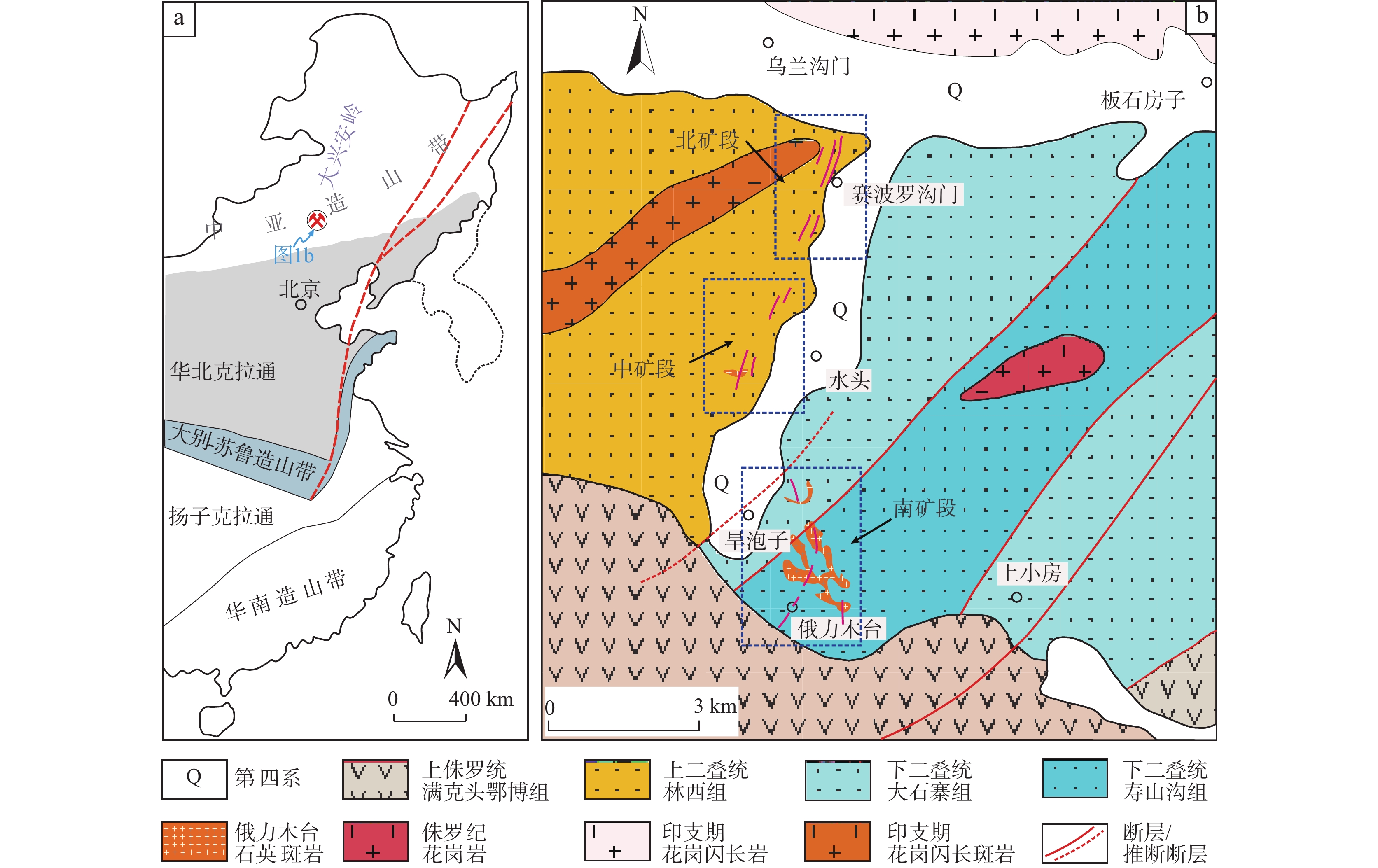
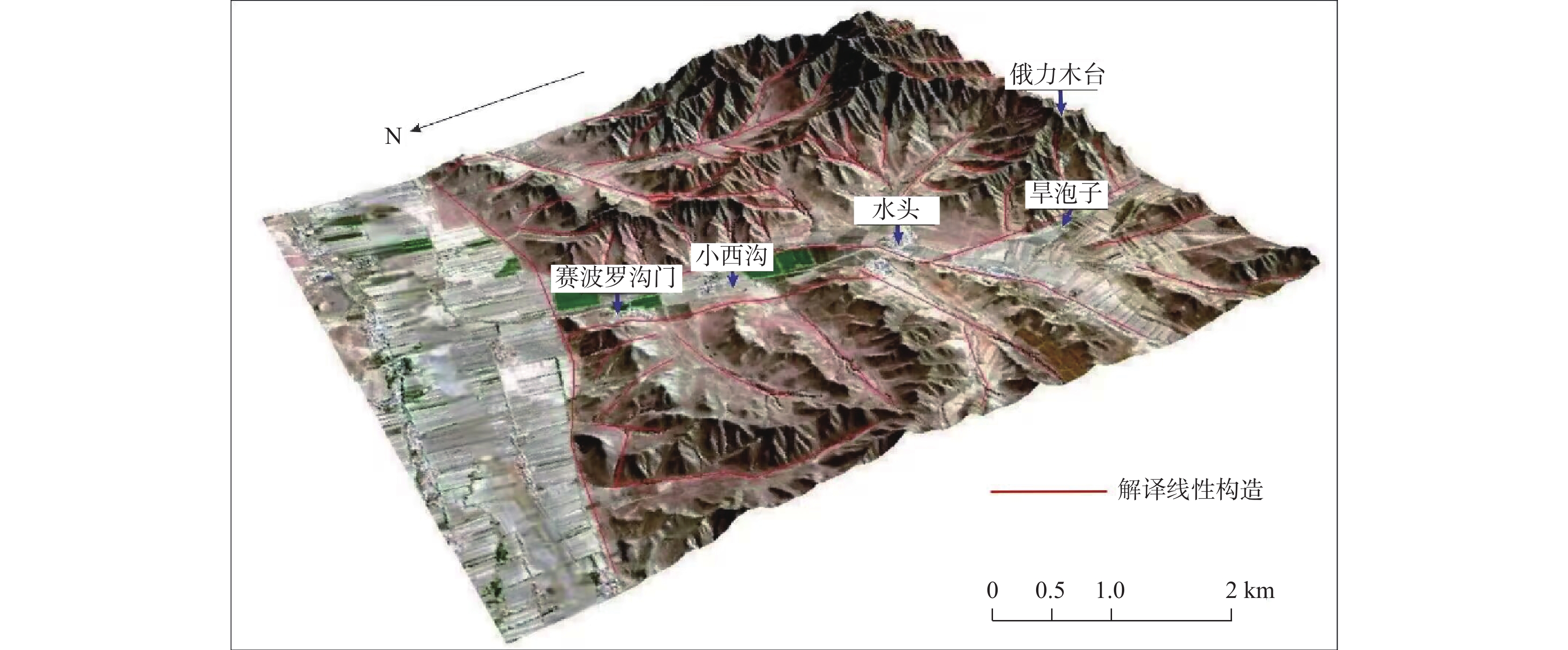
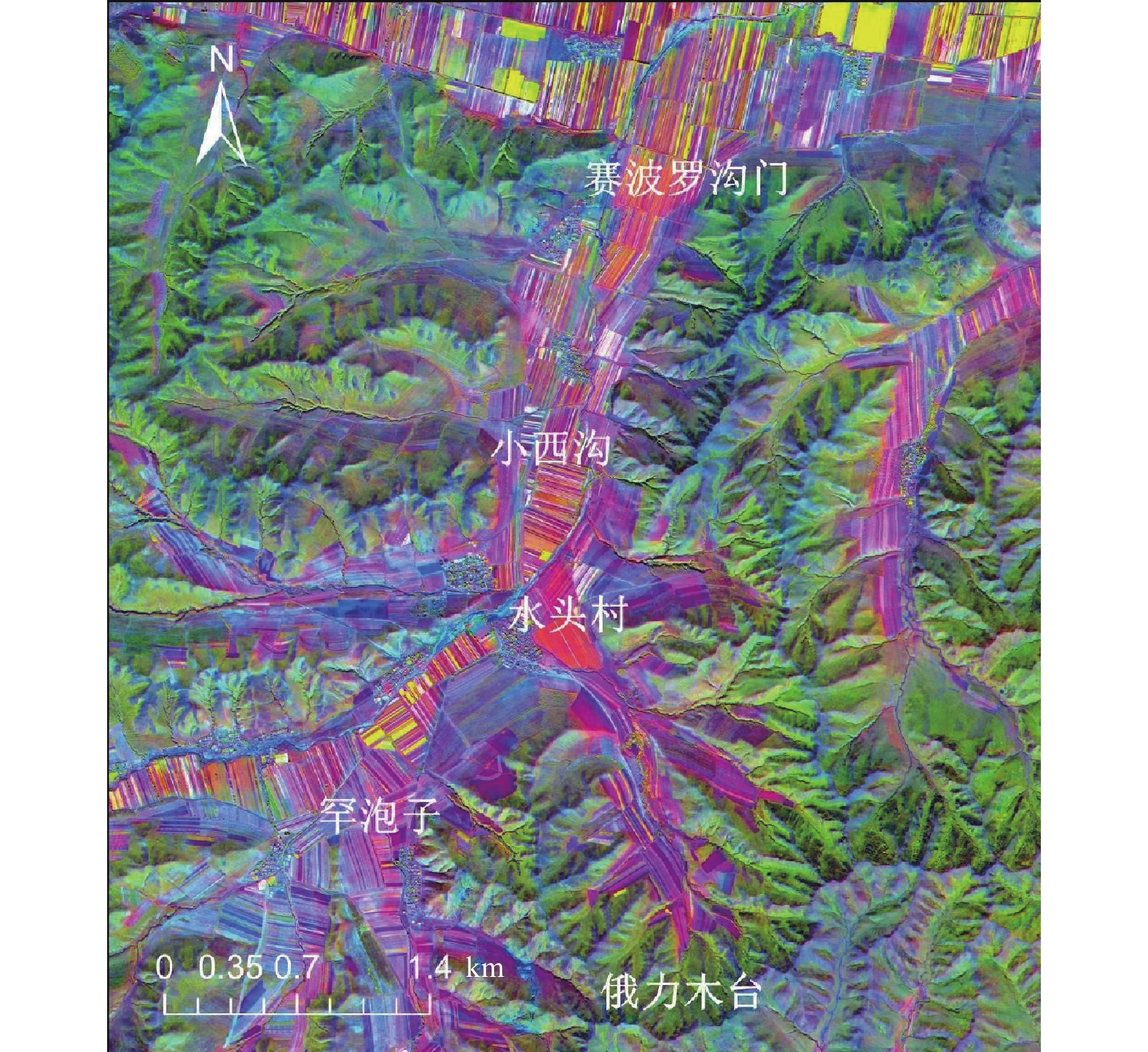
图 1 研究区位置图(a)与水头萤石矿床地质简图(b) (据Pei et al., 2017修)
Figure 1.
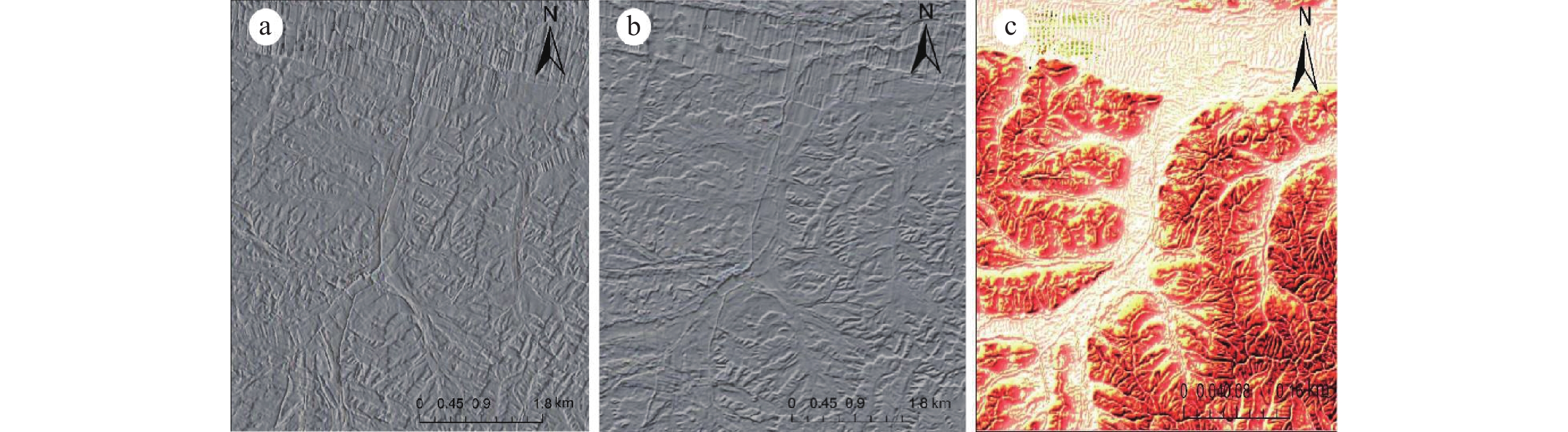
表 1 研究区线性构造解译标志
Table 1. Linear structural deciphering signs in the study area
走向 NNE NE NS NW NS 影像特征 线性影像两侧具有明显的色调和纹理差异,右侧被第四系覆盖地势平坦,左侧地势起伏较大 山脊沿走向错断明显,形成延伸较短山脊 平行且直线延伸的
沟谷区域地表破碎,冲沟发育 呈直线延伸的断层三角面,线性特征两侧色调和纹理差异
较大最佳波段组合影像 


 下载: 导出CSV
表 2 Sentinel-2波段(2, 4, 8A, 11)特征向量值
Table 2. Sentinel-2 band (2, 4, 8A, 11) eigenvector values
特征向量 Band 2 Band 4 Band 8A Band11 PCA 1 0.228008 0.485797 0.529531 0.656971 PCA 2 −0.248006 −0.465049 −0.398096 0.750827 PCA 3 0.837512 0.106257 −0.532612 0.060057 PCA 4 0.430207 −0.732421 0.526726 −0.032271
下载: 导出CSV
表 3 ASTER 波段(1, 2, 3, 4)特征向量值
Table 3. ASTER band (1, 2, 3, 4) eigenvector values
特征向量 Band 1 Band 2 Band 3 Band 4 PCA 1 0.366091 0.501476 0.544108 0.564309 PCA 2 0.358618 0.385511 0.247074 −0.813467 PCA 3 −0.531336 −0.300564 0.779598 −0.139893 PCA 4 −0.674576 0.713838 −0.187421 −0.016018
下载: 导出CSV
表 4 Sentinel-2波段(2, 8A, 11, 12)特征向量值
Table 4. Sentinel-2 band (2, 8A, 11, 12) eigenvector values
特征向量 Band 2 Band 8A Band 11 Band 12 PCA 1 0.214945 0.462860 0.623654 0.592127 PCA 2 0.076734 −0.741924 −0.100916 0.658389 PCA 3 0.775354 0.257379 −0.565524 0.112987 PCA 4 0.588844 −0.411175 0.530146 −0.450714
下载: 导出CSV
表 5 ASTER波段(1, 3, 4, 8)特征向量值
Table 5. Eigenvector values for ASTER bands (1, 3, 4, 8)
特征向量 Band 1 Band 3 Band 4 Band 8 PCA 1 0.301105 0.461674 0.561204 0.617449 PCA 2 0.501821 0.596173 −0.075151 −0.622178 PCA 3 0.313634 0.135309 −0.807917 0.480203 PCA 4 0.74776 −0.642749 0.163316 −0.032501
下载: 导出CSV
-
[1] 曹华文, 张寿庭, 邹灏, 等. 内蒙古林西萤石矿床石英ESR年龄及其地质意义[J]. 现代地质, 2013, 27(4): 888−894. doi: 10.3969/j.issn.1000-8527.2013.04.015
CAO Huawen, ZHANG Shouting, ZOU Hao, et al. ESR dating of quartz from Linxi fluorite deposits, Inner Mongolia and its geological implications[J]. Geoscience,2013,27(4):888−894. doi: 10.3969/j.issn.1000-8527.2013.04.015
[2] 曾庆栋, 刘建明, 褚少雄, 等. 大兴安岭南段多金属矿成矿作用和找矿潜力[J]. 吉林大学学报(地球科学版), 2016, 46(04): 1100−1123.
ZENG Qingdong, LIU Jianming, CHU Shaoxiong, et al. Poly-metal mineralization and exploration potential in southern Segment of the Da Hinggan mountains[J]. Journal of Jilin University (Earth Science Edition),2016,46(04):1100−1123.
[3] 陈江, 王安建. 利用ASTER热红外遥感数据开展岩石化学成分填图的初步研究[J]. 遥感学报, 2007(04): 601−608.
CHEN Jiang, WANG Anjian. The pilot study on petrochemistry components mapping with ASTER thermal infrared remote sensing data[J]. Journal of Remote Sensing,2007(04):601−608.
[4] 陈军元, 刘艳飞, 颜玲亚, 等. 石墨、萤石等战略非金属矿产发展趋势研究[J]. 地球学报, 2021, 42(02): 287−296.
CHEN Junyuan, LIU Yanfei, YAN Lingya, et al. Research on development trend of strategic nonmetallic minerals such as graphite and fluorite[J]. Acta Geoscientica Sinica,2021,42(02):287−296.
[5] 代晶晶, 王登红, 王海宇. 我国三稀矿产资源遥感调查综述[J]. 地质学报, 2019, 93(06): 1270−1278. doi: 10.3969/j.issn.0001-5717.2019.06.008
DAI Jingjing, WANG Denghong, WANG Haiyu. A review of the three type rare mineral resources survey in China using remote sensing[J]. Acta Geologica Sinica,2019,93(06):1270−1278. doi: 10.3969/j.issn.0001-5717.2019.06.008
[6] 丁俊, 李玉森, 何长宇, 等. 刚果(布)Mpassa-Moubiri铜多金属矿区多源遥感蚀变矿化异常提取[J]. 矿产勘查, 2024, 15(03): 384−394.
DING Jun, LI Yusen, HE Changyu, et al. Extraction of multi-source remote sensing alteration-mineralization anomalies in the Mpassa-Moubiri copper-polymetallic mining district, Congo[J]. Mineral Exploration,2024,15(03):384−394.
[7] 郭建栋, 朱谷昌, 傅朝义, 等. 基于Sentinel-2A影像对中非Cu-Co成矿带莫坎博地区地层构造解译分析研究[J]. 矿产勘查, 2022, 13(10): 1491−1497.
GUO Jiandong, ZHU Guchang, FU Chaoyi, et al. Interpretation and analysis of stratigraphic structures in the Mokambo region of the central African Cu-Co metallogenic belt based on Sentinel-2A images[J]. Mineral Exploration,2022,13(10):1491−1497.
[8] 韩燿徽, 王翠芝, 吴志杰, 等. 内蒙古赤峰柴胡栏子金矿田遥感地质解译和蚀变信息提取与找矿预测[J/OL]. 现代地质, 2023,1−16.
HAN Yaohui,WANG Cuizhi,WU Zhijie,et al. Remote sensing geological interpretation,alteration information extraction,and mineral prospecting prediction in the Chaihulanzi gold ore field in Chifeng,Inner Mongolia[J/OL]. Geoscience,2023, 1−16.
[9] 黄理善, 朱景和, 胡祥云, 等. 新疆喀喇昆仑地区伟晶岩型锂矿床综合找矿信息特征与找矿预测[J]. 矿产勘查, 2023, 14(09): 1525−1544.
HUANG Lishan, ZHU Jinghe, HU Xiangyun, et al. Comprehensive prospecting information characteristics and prospecting prediction of pegmatite type lithium deposits in Karakoram area, Xinjiang[J]. Mineral Exploration,2023,14(09):1525−1544.
[10] 蒋意如, 叶江, 谢璋琳, 等. 基于时序Sentinel-2影像物候特征分析的油菜种植范围提取研究[J/OL]. 成都理工大学学报(自然科学版), 2024, 1−21.
JIANG Yiru, YE Jiang, XIE Zhanglin, et al. Rape planting extraction based on phenological characteristics analysis of time series Sentinel-2 images[J/OL]. Journal of Chengdu University of Technology (Science & Technology Edition), 2024, 1−21.
[11] 李斯, 李冬月, 鲁佳, 等. 秘鲁奇克拉约东部斑岩型铜矿带遥感找矿预测[J]. 矿产勘查, 2023, 14(11): 2135−2142.
LI Si, LI Dongyue, LU Jia, et al. Remote sensing prospecting prediction of the porphyry copper belt, eastern Chiclayo, Peru[J]. Mineral Exploration,2023,14(11):2135−2142.
[12] 刘道飞, 陈圣波, 陈磊, 等. 以SiO2含量为辅助因子的ASTER热红外遥感硅化信息提取[J]. 地球科学(中国地质大学学报), 2015, 40(08): 1396−1402. doi: 10.3799/dqkx.2015.124
LIU Daofei, CHEN Shengbo, CHEN Lei, et al. Silicification information extraction based on the content of SiO2 from ASTER TIR data[J]. Earth Science——Journal of China University of Geosciences,2015,40(08):1396−1402. doi: 10.3799/dqkx.2015.124
[13] 刘磊, 吴朦朦, 尹翠景, 等. 影像空间分辨率对蚀变信息提取结果的影响研究[J]. 遥感技术与应用, 2019, 34(5): 1040−1047.
LIU Lei, WU Mengmeng, YIN Cuijing, et al. Influence of the Different Spatial Resolutions for Alteration Mineral Mapping[J]. Remote Sensing Technology and Application,2019,34(5):1040−1047.
[14] 刘磊, 张婷, 尹芳, 等. 巴基斯坦胡兹达尔-拉斯贝拉铅锌成矿带遥感地质特征与成矿预测[J]. 地质学报, 2022, 96(03): 1012−1025. doi: 10.3969/j.issn.0001-5717.2022.03.017
LIU Lei, ZHANG Ting, YIN Fang, et al. Remote sensing of geological features and mineral prospecting indicators for Pb-Zn deposits in the Khuzdar-Lasbela zone, Pakistan[J]. Acta Geologica Sinica,2022,96(03):1012−1025. doi: 10.3969/j.issn.0001-5717.2022.03.017
[15] 刘志恒, 周绥平, 余航, 等. 融合DEM和遥感影像的黄土区断裂构造识别[J]. 遥感信息, 2023, 38(04): 57−65.
LIU Zhiheng, ZHOU Suiping, YU Hang, et al. Geological fault detection by fusing DEM and remote sensing images in loess coverd area[J]. Remote Sensing Information,2023,38(04):57−65.
[16] 吕毓东, 王世明, 王代强, 等. 基于全波段反射光谱的花岗岩及其主要矿物自动识别研究——以康定某隧道为例[J]. 矿产勘查, 2024, 15(04): 634−643.
LV Yudong, WANG Shiming, WANG Daiqiang, et al. Automatic identification of granite and its main minerals based on all-band reflection spectrum: A case study of a tunnel from Kangding area[J]. Mineral Exploration,2024,15(04):634−643.
[17] 裴秋明, 张寿庭, 曹华文, 等. 内蒙古林西地区小北沟萤石矿床地质特征及找矿潜力分析[J]. 桂林理工大学学报, 2016, 36(03): 426−434. doi: 10.3969/j.issn.1674-9057.2016.03.003
PEI Qiuming, ZHANG Shouting, CAO Huawen, et al. Features and potential analysis of Xiaobeigou fluorite deposit in Linxi, Inner Mongolia[J]. Journal of Guilin University of Technology,2016,36(03):426−434. doi: 10.3969/j.issn.1674-9057.2016.03.003
[18] 裴秋明 . 大兴安岭南段萤石矿成矿规律及隐伏—半隐伏矿体预测 [D]. 北京:中国地质大学(北京). 2018.
PEI Qiuming. A study on metallogenetic regularity and prognosis of concealed ore body in southern Great Xing’an Range,Northeastern China [D]. Beijing: China University of Geosciences (Beijing),2018.
[19] 宋坤, 王恩德, 付建飞, 等. 基于Landsat 8数据的弓长岭矿区遥感蚀变异常信息提取[J]. 金属矿山, 2022(04): 149−157.
SONG Kun, WANG Ende, FU Jianfei, et al. Extraction of remote sensing alteration anomaly information based on Landsat 8 data in Gongchangling mining area[J]. Metal Mine,2022(04):149−157.
[20] 宋伊圩, 王鹏, 连琛芹, 等. 基于ASTER光谱特征的岩性填图和蚀变信息提取: 念扎金矿例析[J]. 西北地质, 2021, 54(02): 126−136.
SONG Yiwei, WANG Peng, LIAN Chenqin, et al. Lithologic mapping and alteration information extracting based on ASTER spectral signature: An example from Nianzha gold deposit[J]. Northwestern Geology,2021,54(02):126−136.
[21] 谭荣, 徐裕敏, 徐先宇, 等. 江西德安彭山矿田遥感找矿预测研究[J/OL]. 岩石矿物学杂志, 2024, 1−8.
TAN Rong,XU Yumin,XU Xianyu,et al. Remote sensing prospecting prediction of Pengshan ore field in De’an County,Jiangxi Province[J/OL]. Acta Petrologica et Mineralogica,2024, 1−8.
[22] 唐超, 周可法, 张楠楠, 等. 基于Landsat-8 OLI和ASTER数据集成和融合的矿化蚀变信息提取: 以包古图斑岩型铜矿为例[J]. 地质科技情报, 2018, 37(06): 211−217.
TANG Chao, ZHOU Kefa, ZHANG Nannan, et al. Alteration information extraction based on integration and fusion of Landsat-8 OLI and ASTER: A case study of Baogutu porphyry copper deposit[J]. Geological Science and Technology Information,2018,37(06):211−217.
[23] 唐利, 张寿庭, 王亮, 等. 浅覆盖区隐伏萤石矿找矿预测: 以内蒙古赤峰俄力木台为例[J]. 地学前缘, 2021, 28(03): 208−220.
TANG Li, ZHANG Shouting, WANG Liang, et al. Exploration of concealed fluorite deposit in shallow overburden areas: A case study in Elimutai, Inner Mongolia, China[J]. Earth Science Frontiers,2021,28(03):208−220.
[24] 王登红, 代鸿章, 刘善宝, 等. 中国战略性关键矿产勘查开发进展与新一轮找矿的建议[J]. 科技导报, 2024, 42(05): 7−25.
WANG Denghong, DAI Hongzhang, LIU Shanbao, et al. Progress in strategic critical minerals exploration and production and proposals for a new round of prospecting in China[J]. Science & Technology Review,2024,42(05):7−25.
[25] 王辉, 范玉海, 杨金中, 等. 高分遥感技术在塔什库尔干铁矿带中的应用[J]. 西北地质, 2017, 50(02): 231−243. doi: 10.3969/j.issn.1009-6248.2017.02.024
WANG Hui, FAN Yuhai, YANG Jinzhong, et al. The application of high resolution remote sensing technology in the Taxkorgan iron ore belt, west Kunlun mountains[J]. Northwestern Geology,2017,50(02):231−243. doi: 10.3969/j.issn.1009-6248.2017.02.024
[26] 王吉平, 朱敬宾, 李敬, 等. 中国萤石矿预测评价模型与资源潜力分析[J]. 地学前缘, 2018, 25(03): 172−178.
WANG Jiping, ZHU Jingbin, LI Jing, et al. Prediction model and resource potential assessment of fluorite deposits in China[J]. Earth Science Frontiers,2018,25(03):172−178.
[27] 王晓云, 井国正, 李文君, 等. 基于多源遥感卫星数据的青海东昆仑沟里地区线性构造识别及找矿预测[J]. 地质科技通报, 2024, 43(1): 326−342.
WANG Xiaoyun, JING Guozheng, LI Wenjun, et al. Lineament mapping and deposit prospecting in the Gouli area, East Kunlun, Qinghai Province: Using multisource remote sensing data[J]. Bulletin of Geological Science and Technology,2024,43(1):326−342.
[28] 魏英娟, 刘欢. 北衙金矿床遥感矿化蚀变信息提取及找矿预测[J]. 自然资源遥感, 2021, 33(03): 156−163.
WEI Yingjuan, LIU Huan. Remote sensing-based mineralized alteration information extraction and prospecting prediction of the Beiya gold deposit, Yunnan Province[J]. Remote Sensing for Natural Resources,2021,33(03):156−163.
[29] 吴畅宇, 代晶晶, 陈伟, 等. 内蒙古苏莫查干敖包萤石矿区遥感蚀变信息提取及其找矿指示意义[J]. 矿床地质, 2023, 42(04): 845−858.
WU Changyu, DAI Jingjing, CHEN Wei, et al. Extraction of remote sensing alteration information and its ore prospecting indication in Sumochagan Obao fluorite mining area, Inner Mongolia[J]. Mineral Deposits,2023,42(04):845−858.
[30] 吴志春, 叶发旺, 郭福生, 等. 主成分分析技术在遥感蚀变信息提取中的应用研究综述[J]. 地球信息科学学报, 2018, 20(11): 1644−1656. doi: 10.12082/dqxxkx.2018.180195
WU Zhichun, YE Fawang, GUO Fusheng, et al. A review on application of techniques of principle component analysis on extracting alteration information of remote sensing[J]. Journal of Geo-information Science,2018,20(11):1644−1656. doi: 10.12082/dqxxkx.2018.180195
[31] 武鼎, 周觅, 王俊虎, 等. 基于哨兵-2数据的白岗岩型铀矿构造蚀变特征研究——以纳米比亚罗辛矿区为例[J]. 铀矿地质, 2024, 40(02): 285−293.
WU Ding, ZHOU Mi, WANG Junhu, et al. Structural and alteration characteristics of alaskite type uranium deposit based on Sentinel-2 data: An example from the Rossing Mine, Namibia[J]. Uranium Geology,2024,40(02):285−293.
[32] 徐旃章, 张寿庭. 浙江省萤石矿时空演化序列与典型萤石矿田的剖析与评价[M]. 北京: 地质出版社, 2013.
XU Zhanzhang, ZHANG Shouting. Spatiotemporal evolution of fluorite deposits and detailed investigation on the typical fluorite district in Zhejiang Province[M]. Beijing: Geological Publishing House, 2013.
[33] 张斌, 张志, 帅爽, 等. 利用Landsat-8和Worldview-2数据进行协同岩性分类[J]. 地质科技情报, 2015, 34(03): 208−213+229.
ZHANG Bin, ZHANG Zhi, SHUAI Shuang, et al. Lithological mapping by using the Synergestic Landsat-8 and Worldview-2 images[J]. Geological Science and Technology Information,2015,34(03):208−213+229.
[34] 张翠芬, 杨晓霞, 郝利娜, 等. 高光谱Hyperion与高分辨率WorldView-2卫星数据协同下的岩性分类[J]. 成都理工大学学报(自然科学版), 2017, 44(05): 613−622.
ZHANG Cuifen, YANG Xiaoxia, HAO Lina, et al. Lithological classification by synergizing hyperspectral Hyperion and high resolution WorldView-2 satellite images[J]. Journal of Chengdu University of Technology (Science & Technology Edition),2017,44(05):613−622.
[35] 张寿庭, 李忠权, 徐旃章. 浙江武义盆地中段萤石矿体垂向分带特征与规律[J]. 西南工学院学报, 1997, 12(04): 54−61.
ZHANG Shouting, LI Zhongquan, XU Zhanzhang. The vertical zonality of fluorite ore-body in the middle part of Wuyi basin, Zhejiang Province[J]. Journal of Southwest Institute of Technology,1997,12(04):54−61.
[36] 张寿庭, 曹华文, 郑硌, 等. 内蒙古林西水头萤石矿床成矿流体特征及成矿过程[J]. 地学前缘, 2014, 21(05): 31−40.
ZHANG Shouting, CAO Huawen, ZHENG Luo, et al. Characteristics of ore-froming fluids and mineralization processes of the Shuitou fluorite deposit in Linxi, Inner Mongolia autonomous region[J]. Earth Science Frontiers,2014,21(05):31−40.
[37] 张夏青, 王洪生, 李志阔, 等. 黑园山北部地区遥感示矿信息提取与找矿预测应用研究[J]. 矿产勘查, 2023, 14(07): 1184−1194.
ZHANG Xiaqing, WANG Hongsheng, LI Zhikuo, et al. Applied research of extraction of remote sensing mine-indicating informationand metallogenic prediction in the north of Heiyuan Mountain, Xinjiang[J]. Mineral Exploration,2023,14(07):1184−1194.
[38] 张彦生, 王亮, 高永璋, 等. 内蒙古林西县水头萤石矿床地质特征、类型及其开发利用价值[J]. 中国地质, 2023, 50(03): 795−805.
ZHANG Yansheng, WANG Liang, GAO Yongzhang, et al. Geological characteristics and types of Shuitou fluorspar deposits in Linxi County, Inner Mongolia, and their development and utilization values[J]. China Geology,2023,50(03):795−805.
[39] 赵龙贤, 代晶晶, 赵元艺, 等. 基于RS和GIS技术的西藏多龙矿集区矿山选址研究[J]. 国土资源遥感, 2021, 33(02): 182−191.
ZHAO Longxian, DAI Jingjing, ZHAO Yuanyi, et al. A study of mine site selection of the Duolong ore concentration area in Tibet based on RS and GIS technology[J]. Remote Sensing for Land and Resources,2021,33(02):182−191.
[40] 赵忠海, 陈俊, 乔锴, 等. 基于分形理论的遥感蚀变信息和构造分析研究: 以黑龙江多宝山地区为例[J]. 现代地质, 2023, 37(01): 153−163.
ZHAO Zhonghai, CHEN Jun, QIAO Kai, et al. Remote sensing alteration and structure analysis based on fractal theory: A case study of Duobaoshan area of Heilongjiang Province[J]. Geoscience,2023,37(01):153−163.
[41] 朱亮璞, 包献华. 浙江武义萤石矿床遥感找矿预测[J]. 环境遥感, 1996(04): 267−272+324.
ZHU Liangpu, BAO Xianhua. Prediction of fluorite deposits using remote sensing data in Wuyi area, Zhejiang Province[J]. Remote Sensing of Environment China,1996(04):267−272+324.
[42] Amer R , Mezayen E A , Hasanein M . ASTER spectral analysis for alteration minerals associated with gold mineralization[J]. Ore Geology Reviews, 2016, 75: 239-251.
[43] Eldougdoug A, Abdelazeem M, Gobashy M, et al. Exploring gold mineralization in altered ultramafic rocks in south Abu Marawat, Eastern Desert, Egypt[J]. Scientific Reports, 2023. 13(1).
[44] Jiang Q, Dai J J, Wang D H, et al. Lithium-bearing Pegmatite Exploration in Western Altun, Xinjiang, using Remote-Sensing Technology[J]. Acta Geologica Sinica-English Edition,2023,97(2):681−694. doi: 10.1111/1755-6724.15025
[45] Li S Z, Suo Y H, Li X Y, et al. Mesozoic tectono-magmatic response in the East Asian ocean-continent connection zone to subduction of the Paleo-Pacific Plate[J]. Earth-Science Reviews,2019,192:91−137. doi: 10.1016/j.earscirev.2019.03.003
[46] Liu L, Feng J L, Han L, et al. Mineral mapping using spaceborne Tiangong-1 hyperspectral imagery and ASTER data: A case study of alteration detection in support of regional geological survey at Jintanzi-Malianquan area, Beishan, Gansu Province, China[J]. Geological Journal,2018,53(S2):372−383. doi: 10.1002/gj.3260
[47] Liu L, Yin C T, Shaheen Khalil Y, et al. Alteration Mapping for Porphyry Cu Targeting in the Western Chagai Belt, Pakistan, Using ZY1-02D Spaceborne Hyperspectral Data[J]. Economic Geology,2024,119(2):331−353. doi: 10.5382/econgeo.5045
[48] Noori L, Pour A, Askari G, et al. Comparison of Different Algorithms to Map Hydrothermal Alteration Zones Using ASTER Remote Sensing Data for Polymetallic Vein-Type Ore Exploration: Toroud–Chahshirin Magmatic Belt (TCMB), North Iran[J]. Remote Sensing, 2019, 11(5).
[49] Pei Q M, Zhang S T, Hayashi K I, et al. Permo–Triassic granitoids of the Xing’an–Mongolia segment of the Central Asian Orogenic Belt, Northeast China: age, composition, and tectonic implications[J]. International Geology Review,2018,60(9):1172−1194. doi: 10.1080/00206814.2017.1377121
[50] Pei Q M, Li C H, Zhang S T, et al. Vein-type fluorite mineralization of the Linxi district in the Great Xing'an Range, Northeast China: Insights from geochronology, mineral geochemistry, fluid inclusion and stable isotope systematics[J]. Ore Geology Reviews,2022,142:104708. doi: 10.1016/j.oregeorev.2022.104708
[51] Pei Q M, Zhang S T, Santosh M, et al. Geochronology, geochemistry, fluid inclusion and C, O and Hf isotope compositions of the Shuitou fluorite deposit, Inner Mongolia, China[J]. Ore Geology Reviews,2017,83:174−190. doi: 10.1016/j.oregeorev.2016.12.022
[52] Pei Q M, Zhang S T, Hayashi K I, et al. Nature and Genesis of the Xiaobeigou Fluorite Deposit, Inner Mongolia, Northeast China: Evidence from Fluid Inclusions and Stable Isotopes[J]. Resource Geology,2019,69(2):148−166. doi: 10.1111/rge.12191
[53] Pour A B, Park T S, Park Y, et al. Landsat-8, Advanced Spaceborne Thermal Emission and Reflection Radiometer, and WorldView-3 Multispectral Satellite Imagery for Prospecting Copper-Gold Mineralization in the Northeastern Inglefield Mobile Belt (IMB), Northwest Greenland[J]. Remote Sensing,2019,11(20).
[54] Sekandari M, Masoumi I, Pour A B, et al. Application of Landsat-8, Sentinel-2, ASTER and WorldView-3 Spectral Imagery for Exploration of Carbonate-Hosted Pb-Zn Deposits in the Central Iranian Terrane (CIT)[J]. Remote Sensing,2020,12(8).
[55] Shebl A, Abdellatif M, Badawi M, et al. Towards better delineation of hydrothermal alterations via multi-sensor remote sensing and airborne geophysical data[J]. Scientific Reports,2023,13(1).
[56] Sorokin A A, Zaika V A, Kovach V P, et al. Timing of closure of the eastern Mongol–Okhotsk Ocean: Constraints from U–Pb and Hf isotopic data of detrital zircons from metasediments along the Dzhagdy Transect[J]. Gondwana Research,2020,81:58−78. doi: 10.1016/j.gr.2019.11.009
[57] Yao F J, Liu S B, Wang D H, et al. Review on the development of multi- and hyperspectral remote sensing technology for exploration of copper–gold deposits[J]. Ore Geology Reviews, 2023. 162.
[58] Zou H, Pei Q M, Li X Y, et al. Application of field-portable geophysical and geochemical methods for tracing the Mesozoic-Cenozoic vein-type fluorite deposits in shallow overburden areas: A case from the Wuliji’Oboo deposit, Inner Mongolia, NE China[J]. Ore Geology Reviews,2022,142:104685. doi: 10.1016/j.oregeorev.2021.104685
-


图(11)
表(5)
计量
- 文章访问数: 1827
- PDF下载数: 0
- 施引文献: 0